Costessey Pits

Lake, Pool, Pond, Freshwater Marsh in Norfolk South Norfolk

England

Costessey Pits
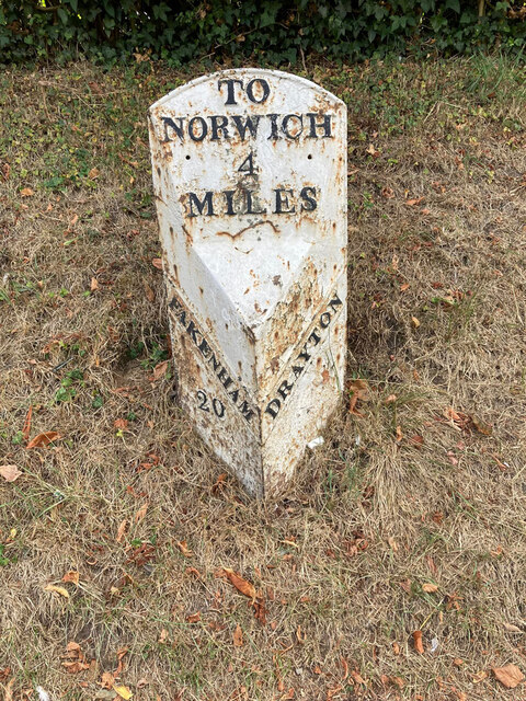
Old Milestone, Drayton On the South side of the A1067, 20yds W of junction with Taverham Road, in the parish of Drayton. Alternative views are <a href="https://www.geograph.org.uk/photo/1391707">TG1713 : Drayton Milestone</a> & <a href="https://www.geograph.org.uk/photo/1558894">TG1713 : Old Milepost</a>.

Inscription: To / Norwich / 4 / Miles // Fakenham / 20 // Drayton

Milestone Society National ID: NO_NF04
Old Milestone, Drayton Credit: Alan Lake

Costessey Pits, located in Norfolk, England, is a natural water feature encompassing a diverse ecosystem. It consists of a series of interconnected lakes, pools, ponds, and freshwater marshes, creating a haven for various flora and fauna.

The area is characterized by its abundant vegetation, including reeds, rushes, and water lilies, which thrive in the nutrient-rich freshwater. This flourishing plant life provides a habitat for a wide range of aquatic species, such as fish, frogs, and insects. Bird enthusiasts will find a wealth of avian diversity, with species like ducks, swans, herons, and kingfishers making the pits their home or using them as a stopover during migration.

The pits also play a crucial role in maintaining the ecological balance of the region. They act as natural floodplain areas, absorbing excess water during periods of heavy rainfall and preventing flooding in surrounding areas. Additionally, the marshes act as filters, purifying the water as it passes through, thus improving water quality downstream.

Costessey Pits is a popular destination for nature enthusiasts and offers various recreational activities. Visitors can enjoy birdwatching, fishing, or simply take a leisurely stroll along the well-maintained footpaths that wind through the area. The pits are also an important educational resource, allowing schools and environmental organizations to study and learn more about wetland ecosystems.

Efforts are made to preserve the natural beauty and ecological significance of the pits. Local conservation groups work diligently to maintain the delicate balance of the ecosystem, ensuring the continued survival of the diverse wildlife that calls Costessey Pits home.

If you have any feedback on the listing, please let us know in the comments section below.

Costessey Pits Images

Images are sourced within 2km of 52.670969/1.1997781 or Grid Reference TG1612. Thanks to Geograph Open Source API. All images are credited.

Old Milestone, Drayton On the South side of the A1067, 20yds W of junction with Taverham Road, in the parish of Drayton. Alternative views are <a href="https://www.geograph.org.uk/photo/1391707">TG1713 : Drayton Milestone</a> & <a href="https://www.geograph.org.uk/photo/1558894">TG1713 : Old Milepost</a>.

Inscription: To / Norwich / 4 / Miles // Fakenham / 20 // Drayton

Milestone Society National ID: NO_NF04
Old Milestone, Drayton
On the South side of the A1067, 20yds W of junction with Taverham Road, in the parish of Drayton. Alternative views are TG1713 : Drayton Milestone & TG1713 : Old Milepost. Inscription: To / Norwich / 4 / Miles // Fakenham / 20 // Drayton Milestone Society National ID: NO_NF04
Bridge Cottage, River Wensum, Costessey Nestling close to the river and the site of an old Toll Bridge, this cottage would have been the toll keeper's residence. The bridge looks to have been collecting tolls as late as 1905, run by a private company. It was not part of the turnpike system and would originally obviated some turnpike miles to Norwich.

Milestone Society National ID: NO.COS
Bridge Cottage, River Wensum, Costessey
Nestling close to the river and the site of an old Toll Bridge, this cottage would have been the toll keeper's residence. The bridge looks to have been collecting tolls as late as 1905, run by a private company. It was not part of the turnpike system and would originally obviated some turnpike miles to Norwich. Milestone Society National ID: NO.COS
Barber, baker and beautician, Drayton On Taverham Road.
Barber, baker and beautician, Drayton
On Taverham Road.
Oops a Daisy, Drayton Florist on Fakenham Road.
Oops a Daisy, Drayton
Florist on Fakenham Road.
Village sign, Drayton Commemorating 50 years since the founding of Drayton 'afternoon W I'.
Village sign, Drayton
Commemorating 50 years since the founding of Drayton 'afternoon W I'.
The Red Lion public house, Drayton The building dates from 1678, becoming an inn in the mid 1700s. Damaged by enemy action in 1942.
The Red Lion public house, Drayton
The building dates from 1678, becoming an inn in the mid 1700s. Damaged by enemy action in 1942.
The Cock Inn, Drayton The present building replaced an 18th century inn in 1956. It was renovated  in 1998-1999. One of the Marston chain of brewers.
The Cock Inn, Drayton
The present building replaced an 18th century inn in 1956. It was renovated in 1998-1999. One of the Marston chain of brewers.
Children's play area, Drayton Playground on School Road, next to St. Margaret's church which can be seen in the background.
Children's play area, Drayton
Playground on School Road, next to St. Margaret's church which can be seen in the background.
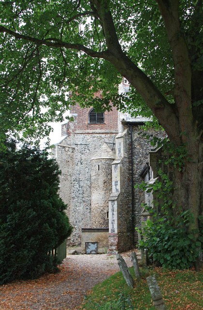
St. Margaret's church, Drayton The church dates from 1198 with some medieval fabric but mainly rebuilt in the 19th century. Inside is a fragment of the 15th century rood screen stair by the pulpit.  Grade II* listed.
St. Margaret's church, Drayton
The church dates from 1198 with some medieval fabric but mainly rebuilt in the 19th century. Inside is a fragment of the 15th century rood screen stair by the pulpit. Grade II* listed.
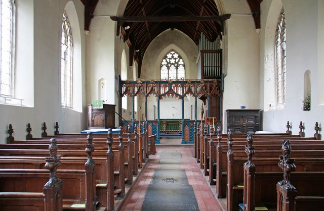
Inside St. Margaret's church, Drayton Looking eastwards along the nave. The church dates from 1198 with some medieval fabric but mainly rebuilt in the 19th century. A fragment of the 15th century rood screen stair can be seen by the pulpit. A Grade II* listed building.
Inside St. Margaret's church, Drayton
Looking eastwards along the nave. The church dates from 1198 with some medieval fabric but mainly rebuilt in the 19th century. A fragment of the 15th century rood screen stair can be seen by the pulpit. A Grade II* listed building.
A poppyhead in St. Margaret's church, Drayton A poppyhead is a form of carving on the top of the end of a bench or a choir stall. Its name is unrelated to the poppy flower but derived by way of Old French, from the Latin word puppis, which means the poop or the figurehead of a ship.
A poppyhead in St. Margaret's church, Drayton
A poppyhead is a form of carving on the top of the end of a bench or a choir stall. Its name is unrelated to the poppy flower but derived by way of Old French, from the Latin word puppis, which means the poop or the figurehead of a ship.
East window, St. Margaret's church, Drayton The church dates from 1198 with some medieval fabric but mainly rebuilt in the 19th century.  A Grade II* listed building.
East window, St. Margaret's church, Drayton
The church dates from 1198 with some medieval fabric but mainly rebuilt in the 19th century. A Grade II* listed building.
18th century gravestone, St. Margaret's church, Drayton A child's grave, John, son of John and Elizabeth Cannell, who died in 1781 in the 6th year of his age.
18th century gravestone, St. Margaret's church, Drayton
A child's grave, John, son of John and Elizabeth Cannell, who died in 1781 in the 6th year of his age.
18th century gravestone, St. Margaret's church, Drayton A detail on a child's grave, John, son of John and Elizabeth Cannell, who died in 1781 in the 6th year of his age.
18th century gravestone, St. Margaret's church, Drayton
A detail on a child's grave, John, son of John and Elizabeth Cannell, who died in 1781 in the 6th year of his age.
Old Milepost by the A1067, Fakenham Road, Taverham Cast iron post by the A1067, in parish of Taverham (Broadland District), Fakenham Road, opposite No. 230, on the verge at rear of footpath against hedge, on West side of road. Fakenham ci n-top, erected by the Norwich & Fakenham turnpike trust in the 19th century. 

Inscription reads:-
: FAKENHAM / 19 : : TO NORWICH / 5 / MILES : : TAVERHAM / 5 :

Norfolk HER.
NHER Number: 56411 <span class="nowrap"><a title="https://www.heritagegateway.org.uk/Gateway/Results_Single.aspx?uid=MNF62817&resourceID=1002" rel="nofollow ugc noopener" href="https://www.heritagegateway.org.uk/Gateway/Results_Single.aspx?uid=MNF62817&resourceID=1002">Link</a><img style="margin-left:2px;" alt="External link" title="External link - shift click to open in new window" src="https://s1.geograph.org.uk/img/external.png" width="10" height="10"/></span>

Milestone Society National ID: NO_NF05
Old Milepost by the A1067, Fakenham Road, Taverham
Cast iron post by the A1067, in parish of Taverham (Broadland District), Fakenham Road, opposite No. 230, on the verge at rear of footpath against hedge, on West side of road. Fakenham ci n-top, erected by the Norwich & Fakenham turnpike trust in the 19th century. Inscription reads:- : FAKENHAM / 19 : : TO NORWICH / 5 / MILES : : TAVERHAM / 5 : Norfolk HER. NHER Number: 56411 LinkExternal link Milestone Society National ID: NO_NF05
St Edmund, Costessey
St Edmund, Costessey - East end
Show me another place!

Costessey Pits is located at Grid Ref: TG1612 (Lat: 52.670969, Lng: 1.1997781)

Administrative County: Norfolk

District: South Norfolk

Police Authority: Norfolk

What 3 Words

///vans.stood.identify. Near Costessey, Norfolk

Related Wikis

Taverham

Taverham is a village and civil parish in Norfolk, in England. It is approximately 5 miles (8 km) north-west of Norwich. Taverham sits on the River Wensum...

Thorpe Marriott

Thorpe Marriott is a residential area in Norfolk, England covering part of Taverham and Drayton parishes. Much of the housing was built in the latter part...

Drayton railway station

Drayton railway station is a former station in Norfolk, England. Constructed by the Midland and Great Northern Joint Railway in the 1880s, on the line...

Taverham Hall School

Taverham Hall School was a private co-educational day and boarding preparatory school. Situated in Taverham, Norfolk, it was founded in 1920. The school...

Have you been to Costessey Pits?

Leave your review of Costessey Pits below (or comments, questions and feedback).