Darwell Reservoir

Lake, Pool, Pond, Freshwater Marsh in Sussex Rother

England

Darwell Reservoir

The Old Stores & Hollingrove Cottage This attractive duo is to be found in the small hamlet of Hollingrove near Brightling. Though each house is quite different from the other in constructional materials, they are both typical of the area. Hollingrove Cottage, furthest from the camera, was in fact three 18th century cottages, now one building, Grade II listed.
The Old Stores & Hollingrove Cottage Credit: Nigel Stickells

Darwell Reservoir, located in East Sussex, England, is a picturesque freshwater lake nestled within the Darwell Woodland. Covering an area of approximately 140 acres, the reservoir serves as a vital source of drinking water for the local communities while also providing a serene recreational spot for nature enthusiasts.

Originally constructed in the late 1960s to meet the growing demand for water in the region, Darwell Reservoir has since become a thriving ecosystem that supports a diverse range of flora and fauna. The reservoir is fed by several natural springs and streams, ensuring a constant flow of fresh water throughout the year.

Surrounded by lush greenery, the reservoir offers a tranquil setting for visitors to enjoy a variety of outdoor activities. Anglers are particularly drawn to the reservoir as it provides excellent fishing opportunities, with an abundance of species including carp, pike, and perch.

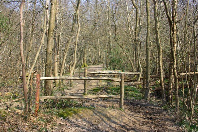
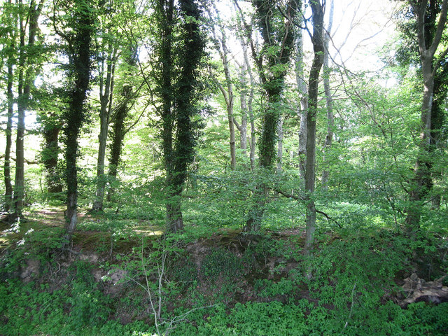
The surrounding woodland and wetland areas, known as Darwell Woodland and Darwell Freshwater Marsh, respectively, add to the reservoir's natural beauty. The woodland is home to a rich assortment of trees such as oak, ash, and beech, providing a habitat for woodland birds and small mammals. The freshwater marsh, on the other hand, is a haven for wetland plants and wetland birds, including reed warblers, water rails, and reed buntings.

Darwell Reservoir offers a network of footpaths and nature trails, allowing visitors to explore the area and take in the stunning views. Whether it's a leisurely stroll, birdwatching, or simply enjoying a picnic by the water's edge, Darwell Reservoir provides a peaceful retreat for all nature lovers.

If you have any feedback on the listing, please let us know in the comments section below.

Darwell Reservoir Images

Images are sourced within 2km of 50.963261/0.43685578 or Grid Reference TQ7121. Thanks to Geograph Open Source API. All images are credited.

The Old Stores & Hollingrove Cottage This attractive duo is to be found in the small hamlet of Hollingrove near Brightling. Though each house is quite different from the other in constructional materials, they are both typical of the area. Hollingrove Cottage, furthest from the camera, was in fact three 18th century cottages, now one building, Grade II listed.
The Old Stores & Hollingrove Cottage
This attractive duo is to be found in the small hamlet of Hollingrove near Brightling. Though each house is quite different from the other in constructional materials, they are both typical of the area. Hollingrove Cottage, furthest from the camera, was in fact three 18th century cottages, now one building, Grade II listed.
Darwell Reservoir Wood boundary A chicane on the bridleway marking the start of the part of Darwell Wood owned by Southern Water, which they have named (along with Scaland Wood) as Darwell Reservoir Wood.
Darwell Reservoir Wood boundary
A chicane on the bridleway marking the start of the part of Darwell Wood owned by Southern Water, which they have named (along with Scaland Wood) as Darwell Reservoir Wood.
Brightling - Mountfield Conveyor
Oast House at Manor Farm, Brightling Road, Oxley Green, East Sussex Single round kiln oast house. A horse and carriage icon to vane.
Oast House at Manor Farm, Brightling Road, Oxley Green, East Sussex
Single round kiln oast house. A horse and carriage icon to vane.
Darwell Wood Darwell Wood is a Site of Special Scientific Interest (biological) in the county of East Sussex.
The site is a broadleaved woodland, with a number of streams flowing into Darwell Reservoir.
<span class="nowrap"><a title="http://www.forestry.gov.uk/pdf/highweald-fdp-darwell-sssi.pdf/$file/highweald-fdp-darwell-sssi.pdf" rel="nofollow ugc noopener" href="http://www.forestry.gov.uk/pdf/highweald-fdp-darwell-sssi.pdf/$file/highweald-fdp-darwell-sssi.pdf">Link</a><img style="margin-left:2px;" alt="External link" title="External link - shift click to open in new window" src="https://s1.geograph.org.uk/img/external.png" width="10" height="10"/></span>
Darwell Wood
Darwell Wood is a Site of Special Scientific Interest (biological) in the county of East Sussex. The site is a broadleaved woodland, with a number of streams flowing into Darwell Reservoir. LinkExternal link
Bridleway, Darwell Wood Darwell Wood is a Site of Special Scientific Interest (biological) in the county of East Sussex.
The site is a broadleaved woodland, with a number of streams flowing into Darwell Reservoir.
<span class="nowrap"><a title="http://www.forestry.gov.uk/pdf/highweald-fdp-darwell-sssi.pdf/$file/highweald-fdp-darwell-sssi.pdf" rel="nofollow ugc noopener" href="http://www.forestry.gov.uk/pdf/highweald-fdp-darwell-sssi.pdf/$file/highweald-fdp-darwell-sssi.pdf">Link</a><img style="margin-left:2px;" alt="External link" title="External link - shift click to open in new window" src="https://s1.geograph.org.uk/img/external.png" width="10" height="10"/></span>
Bridleway, Darwell Wood
Darwell Wood is a Site of Special Scientific Interest (biological) in the county of East Sussex. The site is a broadleaved woodland, with a number of streams flowing into Darwell Reservoir. LinkExternal link
Through Darwell Wood Darwell Wood is a Site of Special Scientific Interest (biological) in the county of East Sussex.
The site is a broadleaved woodland, with a number of streams flowing into Darwell Reservoir.
<span class="nowrap"><a title="http://www.forestry.gov.uk/pdf/highweald-fdp-darwell-sssi.pdf/$file/highweald-fdp-darwell-sssi.pdf" rel="nofollow ugc noopener" href="http://www.forestry.gov.uk/pdf/highweald-fdp-darwell-sssi.pdf/$file/highweald-fdp-darwell-sssi.pdf">Link</a><img style="margin-left:2px;" alt="External link" title="External link - shift click to open in new window" src="https://s1.geograph.org.uk/img/external.png" width="10" height="10"/></span>
Through Darwell Wood
Darwell Wood is a Site of Special Scientific Interest (biological) in the county of East Sussex. The site is a broadleaved woodland, with a number of streams flowing into Darwell Reservoir. LinkExternal link
Darwell Wood Darwell Wood is a Site of Special Scientific Interest (biological) in the county of East Sussex.
The site is a broadleaved woodland, with a number of streams flowing into Darwell Reservoir.
<span class="nowrap"><a title="http://www.forestry.gov.uk/pdf/highweald-fdp-darwell-sssi.pdf/$file/highweald-fdp-darwell-sssi.pdf" rel="nofollow ugc noopener" href="http://www.forestry.gov.uk/pdf/highweald-fdp-darwell-sssi.pdf/$file/highweald-fdp-darwell-sssi.pdf">Link</a><img style="margin-left:2px;" alt="External link" title="External link - shift click to open in new window" src="https://s1.geograph.org.uk/img/external.png" width="10" height="10"/></span>
Darwell Wood
Darwell Wood is a Site of Special Scientific Interest (biological) in the county of East Sussex. The site is a broadleaved woodland, with a number of streams flowing into Darwell Reservoir. LinkExternal link
Coppicing, Darwell Wood Darwell Wood is a Site of Special Scientific Interest (biological) in the county of East Sussex.
The site is a broadleaved woodland, with a number of streams flowing into Darwell Reservoir.
<span class="nowrap"><a title="http://www.forestry.gov.uk/pdf/highweald-fdp-darwell-sssi.pdf/$file/highweald-fdp-darwell-sssi.pdf" rel="nofollow ugc noopener" href="http://www.forestry.gov.uk/pdf/highweald-fdp-darwell-sssi.pdf/$file/highweald-fdp-darwell-sssi.pdf">Link</a><img style="margin-left:2px;" alt="External link" title="External link - shift click to open in new window" src="https://s1.geograph.org.uk/img/external.png" width="10" height="10"/></span>
Coppicing, Darwell Wood
Darwell Wood is a Site of Special Scientific Interest (biological) in the county of East Sussex. The site is a broadleaved woodland, with a number of streams flowing into Darwell Reservoir. LinkExternal link
Darwell Wood Darwell Wood is a Site of Special Scientific Interest (biological) in the county of East Sussex.
The site is a broadleaved woodland, with a number of streams flowing into Darwell Reservoir.
<span class="nowrap"><a title="http://www.forestry.gov.uk/pdf/highweald-fdp-darwell-sssi.pdf/$file/highweald-fdp-darwell-sssi.pdf" rel="nofollow ugc noopener" href="http://www.forestry.gov.uk/pdf/highweald-fdp-darwell-sssi.pdf/$file/highweald-fdp-darwell-sssi.pdf">Link</a><img style="margin-left:2px;" alt="External link" title="External link - shift click to open in new window" src="https://s1.geograph.org.uk/img/external.png" width="10" height="10"/></span>
Darwell Wood
Darwell Wood is a Site of Special Scientific Interest (biological) in the county of East Sussex. The site is a broadleaved woodland, with a number of streams flowing into Darwell Reservoir. LinkExternal link
Muddy Track
Muddy Track
Midland hawthorn in Darwell Wood The native Midland hawthorn (Crataegus laevigata) differs from the common hawthorn (C. monogyna), also native, in its tulip-shaped leaves and fruit with the two styles shown protruding here.  Midland hawthorn is less common that its sister species, but occurs quite widely in calcareous woods in East Sussex.  It flowers earlier than common hawthorn and reports of early-flowering trees often refer unwittingly to C. laevigata.  The hybrid between the two, C. x media is also quite common where the species grow together.
Midland hawthorn in Darwell Wood
The native Midland hawthorn (Crataegus laevigata) differs from the common hawthorn (C. monogyna), also native, in its tulip-shaped leaves and fruit with the two styles shown protruding here. Midland hawthorn is less common that its sister species, but occurs quite widely in calcareous woods in East Sussex. It flowers earlier than common hawthorn and reports of early-flowering trees often refer unwittingly to C. laevigata. The hybrid between the two, C. x media is also quite common where the species grow together.
Limestone cliff in Darwell Wood The Darwell Stream has cut through Purbeck Limestone strata here.  This Jurassic formation is the geological centre of the Weald and its oldest rocks.  There are few exposures like this on the surface and limestone is unusual in South East England.
Limestone cliff in Darwell Wood
The Darwell Stream has cut through Purbeck Limestone strata here. This Jurassic formation is the geological centre of the Weald and its oldest rocks. There are few exposures like this on the surface and limestone is unusual in South East England.
Coppice on Purbeck limestone, Holman's Wood The coppice on limestone in this wood differs from most coppices in the ground layer of grass.  The Purbeck limestone is the geological formation at the centre of the Wealden strata and is the local source of gypsum (Calcium sulphate).
Coppice on Purbeck limestone, Holman's Wood
The coppice on limestone in this wood differs from most coppices in the ground layer of grass. The Purbeck limestone is the geological formation at the centre of the Wealden strata and is the local source of gypsum (Calcium sulphate).
Hunter's Farm to the northwest of Darwell Reservoir Viewed from the Hollingrove to Mountfield road, Hunter's Farm is in an isolated location overlooking the Darwell Reservoir to the southeast. The farmhouse has a half hipped roof and is built of red and grey brick on an ashlar base. It is 18th century, Grade II listed.
Hunter's Farm to the northwest of Darwell Reservoir
Viewed from the Hollingrove to Mountfield road, Hunter's Farm is in an isolated location overlooking the Darwell Reservoir to the southeast. The farmhouse has a half hipped roof and is built of red and grey brick on an ashlar base. It is 18th century, Grade II listed.
The View to Darwell Reservoir This view looking southeastwards to Darwell Reservoir is from the lane between Hollingrove hamlet and Mountfield village, nearby to Hunter's Farm. It is a characteristic view of the unspoilt rolling fields, hedges and woodlands that surround the reservoir.
The View to Darwell Reservoir
This view looking southeastwards to Darwell Reservoir is from the lane between Hollingrove hamlet and Mountfield village, nearby to Hunter's Farm. It is a characteristic view of the unspoilt rolling fields, hedges and woodlands that surround the reservoir.
Mountfield Park Farm near Darwell Reservoir This view of Mountfield Park Farm, complete with oasthouses, looks northwards from Mountfield Lane that skirts the north side of Darwell Reservoir. It 
epitomises the landscape in this part of Wealden Sussex with its rolling fields, hedges & woodlands, and its isolated farmsteads.
Mountfield Park Farm near Darwell Reservoir
This view of Mountfield Park Farm, complete with oasthouses, looks northwards from Mountfield Lane that skirts the north side of Darwell Reservoir. It epitomises the landscape in this part of Wealden Sussex with its rolling fields, hedges & woodlands, and its isolated farmsteads.
Show me another place!

Darwell Reservoir is located at Grid Ref: TQ7121 (Lat: 50.963261, Lng: 0.43685578)

Administrative County: East Sussex

District: Rother

Police Authority: Sussex

What 3 Words

///downsize.tickling.chats. Near Robertsbridge, East Sussex

Related Wikis

Darwell Reservoir

Darwell Reservoir lies to the west of Mountfield, East Sussex, England. The reservoir provides water for Southern Water customers. The reservoir covers...

Darwell Wood

Darwell Wood is a 37.5-hectare (93-acre) biological Site of Special Scientific Interest north-west of Battle in East Sussex. == Species == Most of the...

Glottenham Castle

Glottenham Castle was a castle in Mountfield, East Sussex, around 5 miles (8 km) north of Battle Abbey. Built in the 13th century, it was abandoned in...

River Line SSSI

River Line SSSI is a 2.2-hectare (5.4-acre) geological Site of Special Scientific Interest south of Robertsbridge in East Sussex. It is a Geological Conservation...

Netherfield, East Sussex

Netherfield is a village in the civil parish of Battle, in the Rother district, in the county of East Sussex, England.In the 1870-1872 Imperial Gazetteer...

Brightling

Brightling is a village and civil parish in the Rother district of East Sussex, England. It is located on the Weald eight miles (13 km) north-west of Battle...

Mountfield, East Sussex

Mountfield is a village and civil parish in the Rother district of East Sussex, England, and three miles (5 km) north-west of Battle. It is mentioned in...

Robertsbridge Community College

Robertsbridge Community College is a coeducational secondary school located in Robertsbridge in the English county of East Sussex.It was established in...

Have you been to Darwell Reservoir?

Leave your review of Darwell Reservoir below (or comments, questions and feedback).