Poplar Dock Cut

Lake, Pool, Pond, Freshwater Marsh in Middlesex

England

Poplar Dock Cut

Royal Victoria Dock, London, E16 Looking west along the Royal Victoria Dock, this image is taken from the High footbridge which links the housing development at Britannia Village (behind the cranes) with the Dockland Light Railway station on the north side of the dock. Canary Wharf is visible on the horizon.
Royal Victoria Dock, London, E16 Credit: Peter Jordan

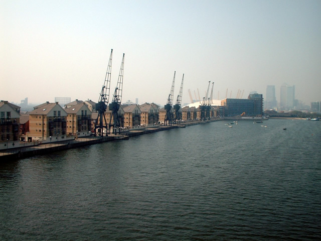
Poplar Dock Cut is a man-made waterway located in Middlesex, England. It is a popular destination for nature enthusiasts and anglers alike. The cut was created in the 19th century as a way to connect Poplar Dock to the River Thames, allowing for easier transportation of goods.

The waterway is approximately 1.5 miles long and is surrounded by a mix of residential and industrial areas. It is a tranquil spot amidst the bustling city, offering a peaceful environment for visitors to enjoy. The water in the cut is predominantly freshwater and is home to a variety of aquatic life.

Poplar Dock Cut is known for its diverse range of habitats. It features a lake, pool, pond, and freshwater marsh, each supporting its own unique ecosystem. The lake is the largest body of water in the area and provides a habitat for various species of fish, such as roach, bream, and perch. The pool and pond are smaller bodies of water that attract a variety of bird species, including ducks and swans.

The freshwater marsh is an important habitat for a range of wildlife, including insects, amphibians, and reptiles. It is also home to a variety of plant species, some of which are considered rare or endangered. The marsh provides a valuable breeding ground for these species and plays a crucial role in maintaining the overall biodiversity of the area.

Overall, Poplar Dock Cut offers a unique opportunity to explore and appreciate the natural beauty of Middlesex. Whether it's fishing, birdwatching, or simply enjoying a peaceful stroll along its banks, visitors are sure to be captivated by the charm and serenity of this man-made waterway.

If you have any feedback on the listing, please let us know in the comments section below.

Poplar Dock Cut Images

Images are sourced within 2km of 51.504581/-0.00913493 or Grid Reference TQ3880. Thanks to Geograph Open Source API. All images are credited.

Royal Victoria Dock, London, E16 Looking west along the Royal Victoria Dock, this image is taken from the High footbridge which links the housing development at Britannia Village (behind the cranes) with the Dockland Light Railway station on the north side of the dock. Canary Wharf is visible on the horizon.
Royal Victoria Dock, London, E16
Looking west along the Royal Victoria Dock, this image is taken from the High footbridge which links the housing development at Britannia Village (behind the cranes) with the Dockland Light Railway station on the north side of the dock. Canary Wharf is visible on the horizon.
Royal Victoria Dock This is taken from the Royal Victoria Dock footbridge, looking west towards central London.
Royal Victoria Dock
This is taken from the Royal Victoria Dock footbridge, looking west towards central London.
Royal Victoria DLR station No. 93 is the trailing unit in this westbound train about to depart Royal Victoria DLR station.
Royal Victoria DLR station
No. 93 is the trailing unit in this westbound train about to depart Royal Victoria DLR station.
Munday Road, E16 Near Appleby Road.
Munday Road, E16
Near Appleby Road.
Appleby Road, E16 Near Munday Road.
Appleby Road, E16
Near Munday Road.
Royal Victoria Dock Royal Victoria Dock, with the Millennium Dome & Canary Wharf skyscrapers in the background. Taken from outside the Excel Arena.
Royal Victoria Dock
Royal Victoria Dock, with the Millennium Dome & Canary Wharf skyscrapers in the background. Taken from outside the Excel Arena.
Sir Henry Johnson Pub/Restaurant in the Royal Victoria Docks near the Excel Centre and sailing school.
Sir Henry Johnson
Pub/Restaurant in the Royal Victoria Docks near the Excel Centre and sailing school.
London Excel, Woolwich Welcome to the London Excel Exhibition Centre! This is the main entrance to the site viewed from the roundabout. I'm unsure of the exact location of this image as I don't know the area that well, so if anybody can help identify the correct location, I'd be very grateful!
London Excel, Woolwich
Welcome to the London Excel Exhibition Centre! This is the main entrance to the site viewed from the roundabout. I'm unsure of the exact location of this image as I don't know the area that well, so if anybody can help identify the correct location, I'd be very grateful!
Artistic street lighting on the roundabout to the Excel Centre Now this is artistic! On the last roundabout before the Excel Centre is a dome-shaped structure with yellow girders (apologies to the designer, I couldn't think of any better word for them!) with standard road lamps fitted to them! Very contemporary and original indeed! View looking northwest from the roundabout, but I'm unsure of the exact location.
Artistic street lighting on the roundabout to the Excel Centre
Now this is artistic! On the last roundabout before the Excel Centre is a dome-shaped structure with yellow girders (apologies to the designer, I couldn't think of any better word for them!) with standard road lamps fitted to them! Very contemporary and original indeed! View looking northwest from the roundabout, but I'm unsure of the exact location.
In Royal Victoria DLR station Looking back from the rear of a train bound for Beckton.
In Royal Victoria DLR station
Looking back from the rear of a train bound for Beckton.
Polar Sundial A 'polar' sundial - explanation at  <span class="nowrap"><a title="http://www.qwerty.co.za/sundials/types/polar.html" rel="nofollow ugc noopener" href="http://www.qwerty.co.za/sundials/types/polar.html">Link</a><img style="margin-left:2px;" alt="External link" title="External link - shift click to open in new window" src="https://s1.geograph.org.uk/img/external.png" width="10" height="10"/></span> - on the Thames Path, erected by the Royal Engineers for the Millennium.  It has two scales, one reading Greenwich Mean Time, and one for British Summer Time.
Polar Sundial
A 'polar' sundial - explanation at LinkExternal link - on the Thames Path, erected by the Royal Engineers for the Millennium. It has two scales, one reading Greenwich Mean Time, and one for British Summer Time.
Polar Sundial, Greenwich 16.39, on a late August day.  Plenty of sun, but not in this location, since it appears to be shaded by a block of flats!
<span class="nowrap"><a title="http://www.qwerty.co.za/sundials/types/polar.html" rel="nofollow ugc noopener" href="http://www.qwerty.co.za/sundials/types/polar.html">Link</a><img style="margin-left:2px;" alt="External link" title="External link - shift click to open in new window" src="https://s1.geograph.org.uk/img/external.png" width="10" height="10"/></span>
Polar Sundial, Greenwich
16.39, on a late August day. Plenty of sun, but not in this location, since it appears to be shaded by a block of flats! LinkExternal link
Water Lilies in reflection
Tower blocks and moat, Greenwich Externally colourful flats which form part of the Millennium Village and abut the Peninsula Ecology Park.
Tower blocks and moat, Greenwich
Externally colourful flats which form part of the Millennium Village and abut the Peninsula Ecology Park.
Emirates Air Line London Cable Car is a Transport for London gondola link across the River Thames, that was built with sponsorship from the air carrier Emirates for the 2012 London Olympics. The scheme, comprises a 1 km cable car line that crosses the river from the Greenwich Peninsula to the Royal Docks, linking two important Olympic sites. The project, estimated to cost £60 million, began construction in August 2011. From October 2022 it will be sponsored by IFS.
Wikipedia: <span class="nowrap"><a title="https://en.wikipedia.org/wiki/London_Cable_Car" rel="nofollow ugc noopener" href="https://en.wikipedia.org/wiki/London_Cable_Car">Link</a><img style="margin-left:2px;" alt="External link" title="External link - shift click to open in new window" src="https://s1.geograph.org.uk/img/external.png" width="10" height="10"/></span>
Emirates Air Line
London Cable Car is a Transport for London gondola link across the River Thames, that was built with sponsorship from the air carrier Emirates for the 2012 London Olympics. The scheme, comprises a 1 km cable car line that crosses the river from the Greenwich Peninsula to the Royal Docks, linking two important Olympic sites. The project, estimated to cost £60 million, began construction in August 2011. From October 2022 it will be sponsored by IFS. Wikipedia: LinkExternal link
Royal Victoria Dock The western end of the Royal Victoria Dock, which closed to commercial shipping in 1981 and has since been redeveloped by the London Docklands Development Corporation.  On the right is the north terminal of the London Cable Car, connecting the area to North Greenwich on the opposite bank of the River Thames.
Royal Victoria Dock
The western end of the Royal Victoria Dock, which closed to commercial shipping in 1981 and has since been redeveloped by the London Docklands Development Corporation. On the right is the north terminal of the London Cable Car, connecting the area to North Greenwich on the opposite bank of the River Thames.
Royal Victoria DLR station
View of Emirates Skyline view from Western Gateway
Show me another place!

Poplar Dock Cut is located at Grid Ref: TQ3880 (Lat: 51.504581, Lng: -0.00913493)

Unitary Authority: Tower Hamlets

Police Authority: Metropolitan

What 3 Words

///stir.reef.keep. Near Canary Wharf, London

Related Wikis

Jamestown Harbour

Jamestown Harbour is a low-density luxury housing development of 73 homes in Poplar in East London, situated between Poplar Dock and Blackwall Marina,...

Poplar Dock

Poplar Dock is a small dock in east London. It connects to the Blackwall Basin of the West India Docks and, although independent of this system, has never...

Coldharbour, Tower Hamlets

Coldharbour is a street and wider conservation area in Blackwall, lying on the north bank of the River Thames, east of Canary Wharf. The area is said to...

Wood Wharf

Wood Wharf is a 23 acre site in Canary Wharf, London. It is currently under construction to provide offices, residential homes and retail space. The site...
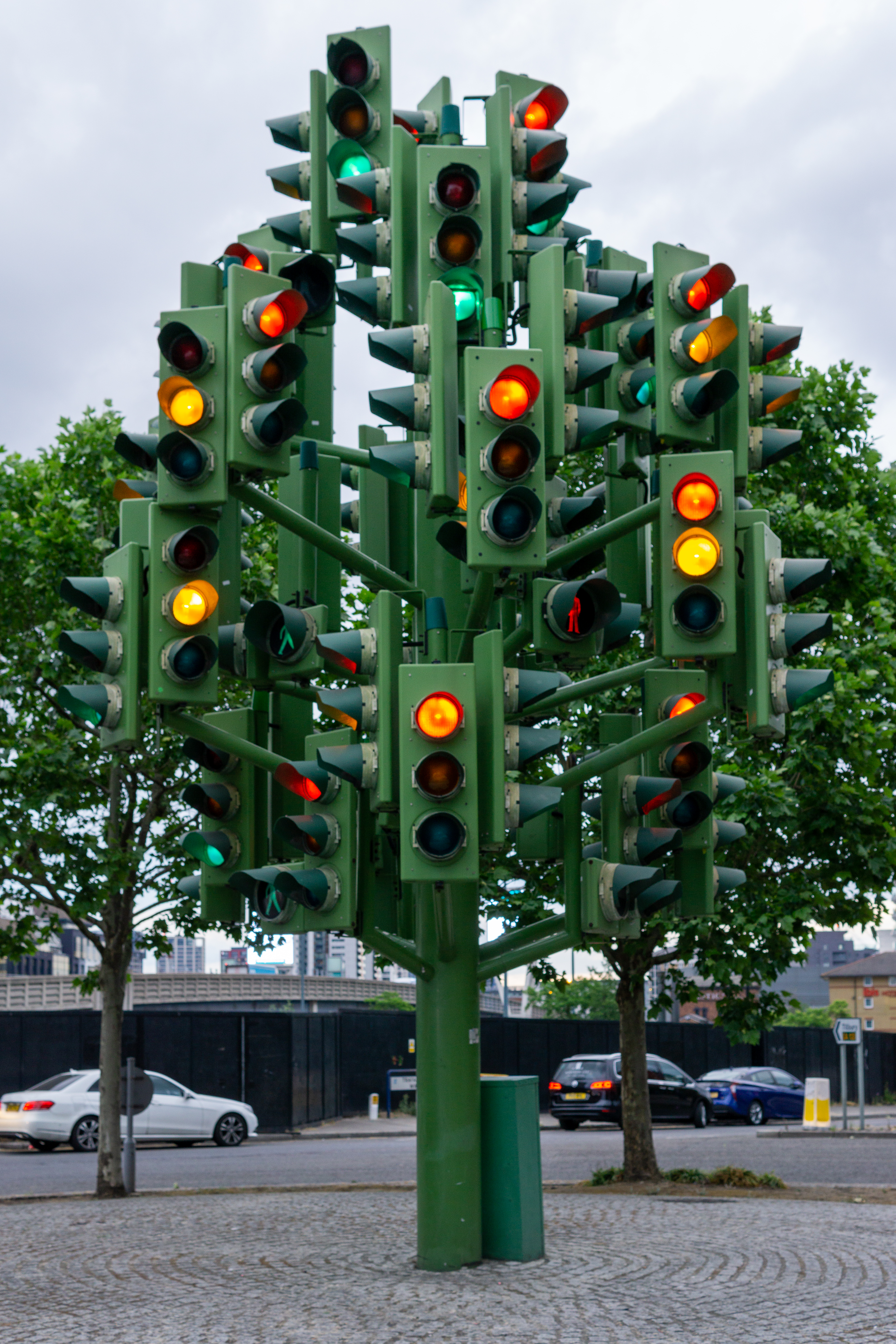
Traffic Light Tree

Traffic Light Tree is a public sculpture in Poplar, London, England, created by the French sculptor Pierre Vivant following a competition run by the Public...

One Park Drive

One Park Drive is a residential skyscraper situated in the south west corner of Wood Wharf, within the Canary Wharf development on the Isle of Dogs, London...

The Gun, Coldharbour

The Gun is a Grade II listed public house at 27 Coldharbour, Coldharbour, London. It takes its name from the cannon which was fired when the West India...

South Dock railway station

South Dock was a railway station on the Isle of Dogs in east London. It was between Millwall Junction and Millwall Docks on the Millwall Extension Railway...

Nearby Amenities

Located within 500m of 51.504581,-0.00913493
Traffic Signals
Traffic Signals Direction: forward
Lat/Long: 51.5075339/-0.0075078
Traffic Signals
Crossing: no
Traffic Signals: traffic_lights
Traffic Signals Direction: forward
Lat/Long: 51.5071368/-0.0079312
Created By: YahooApplet 1.0
Lat/Long: 51.507102/-0.0136939
Crossing
Button Operated: yes
Crossing: traffic_signals
Crossing Island: no
Tactile Paving: yes
Traffic Signals Sound: yes
Traffic Signals Vibration: yes
Lat/Long: 51.5024041/-0.008502
Barrier: lift_gate
Lat/Long: 51.5010564/-0.0087781
Blackwall Platform 1
Light Rail: yes
Network: Docklands Light Railway
Public Transport: stop_position
Railway: stop
Ref: 1
Lat/Long: 51.5080368/-0.0066576
Blackwall
Is In: Tower hamlets, London
Place: suburb
Wikidata: Q122767
Wikipedia: en:Blackwall, London
Lat/Long: 51.5065004/-0.0064024
Railway: switch
Lat/Long: 51.5074951/-0.0141909
Created By: YahooApplet 1.0
Lat/Long: 51.507691/-0.0058757
Traffic Signals
Traffic Signals Direction: forward
Lat/Long: 51.5074888/-0.0073441
Railway: buffer_stop
Lat/Long: 51.5079658/-0.0123433
Railway: buffer_stop
Lat/Long: 51.5079226/-0.0123412
Railway: buffer_stop
Lat/Long: 51.5078202/-0.0124079
Railway: switch
Lat/Long: 51.5076328/-0.0131451
Railway: switch
Lat/Long: 51.507603/-0.012547
Railway: switch
Lat/Long: 51.5078787/-0.013818
Railway: switch
Lat/Long: 51.507695/-0.0130671
Railway: switch
Lat/Long: 51.5077611/-0.0136885
Railway: switch
Lat/Long: 51.50782/-0.013587
Crossing
Bicycle: yes
Button Operated: no
Check Date Crossing: 2021-03-30
Crossing: traffic_signals
Crossing Island: yes
Tactile Paving: yes
Traffic Signals Sound: yes
Traffic Signals Vibration: no
Lat/Long: 51.5051692/-0.0071286
Mini Roundabout
Direction: clockwise
Lat/Long: 51.5069217/-0.0066049
Traffic Signals
Traffic Signals: signal
Traffic Signals Direction: forward
Lat/Long: 51.5067492/-0.007378
Traffic Signals
Traffic Signals: signal
Traffic Signals Direction: forward
Lat/Long: 51.5069953/-0.0078827
Crossing
Bicycle: yes
Button Operated: yes
Crossing: traffic_signals
Crossing Island: no
Crossing Ref: toucan
Lat/Long: 51.5070233/-0.0079271
Mini Roundabout
Direction: clockwise
Lat/Long: 51.5053464/-0.0058474
Mini Roundabout
Direction: clockwise
Lat/Long: 51.5067633/-0.0064109
Crossing
Crossing: unmarked
Crossing Island: separate
Tactile Paving: no
Lat/Long: 51.5082419/-0.0085107
Tactile Paving: yes
Lat/Long: 51.5089095/-0.0094753
Car Sharing
Capacity: 1
Operator: Streetcar
Operator Wikidata: Q7623070
Source: WebSite
Lat/Long: 51.5052751/-0.0098854
Barrier: lift_gate
Lat/Long: 51.5013794/-0.0087347
Traffic Signals
Crossing: no
Traffic Signals: traffic_lights
Traffic Signals Direction: forward
Lat/Long: 51.5080695/-0.0083297
Traffic Signals
Crossing: no
Traffic Signals: traffic_lights
Traffic Signals Direction: forward
Lat/Long: 51.5079374/-0.0083873
Crossing
Crossing: uncontrolled
Crossing Island: separate
Crossing Markings: zebra;dots
Crossing Ref: zebra
Tactile Paving: yes
Lat/Long: 51.5067218/-0.0094202
Traffic Signals
Lat/Long: 51.5047395/-0.0154468
Railway: switch
Lat/Long: 51.5077235/-0.0135331
Railway: buffer_stop
Lat/Long: 51.5077382/-0.0119657
Railway: buffer_stop
Lat/Long: 51.5076819/-0.0120289
Railway: switch
Lat/Long: 51.5074665/-0.0144616
Railway: switch
Lat/Long: 51.507456/-0.0132073
Railway: switch
Lat/Long: 51.5076483/-0.0136299
Bus Stop
Blackwall Station
Bench: yes
Bin: yes
Bus: yes
Lit: yes
Local Ref: AP
Naptan AtcoCode: 490002018AP
Naptan Bearing: S
Naptan CommonName: Blackwall
Naptan Indicator: Stop AP
Naptan Street: DITCHBURN STREET
Public Transport: platform
Ref: 76101
Shelter: no
Tactile Paving: no
Wheelchair: yes
Lat/Long: 51.5083005/-0.0069622
Bus Stop
Blackwall Station
Bench: yes
Bin: yes
Bus: yes
Lit: yes
Local Ref: P
Naptan AtcoCode: 490002018P
Naptan Bearing: N
Naptan CommonName: Blackwall
Naptan Indicator: Stop P
Naptan Street: DITCHBURN STREET
Public Transport: platform
Ref: 56655
Shelter: yes
Tactile Paving: no
Wheelchair: yes
Lat/Long: 51.5083098/-0.0073903
Bus Stop
Aspen Way
Bench: yes
Bin: yes
Bus: yes
Lit: yes
Local Ref: Q
Naptan AtcoCode: 490003459Q
Naptan Bearing: S
Naptan CommonName: Aspen Way
Naptan Street: PRESTON'S ROAD
Public Transport: platform
Ref: 75813
Shelter: yes
Source Local Ref: naptan
Tactile Paving: no
Lat/Long: 51.5060336/-0.0074502
Bus Stop
Aspen Way
Bench: yes
Bin: yes
Bus: yes
Lit: yes
Local Ref: R
Naptan AtcoCode: 490003459R
Naptan Bearing: S
Naptan CommonName: Aspen Way
Naptan Indicator: R
Naptan Street: PRESTON'S ROAD
Public Transport: platform
Ref: 77547
Shelter: yes
Tactile Paving: no
Lat/Long: 51.5063071/-0.0076549
Bus Stop
Coldharbour
Bench: yes
Bin: yes
Bus: yes
Lit: yes
Local Ref: F
Naptan AtcoCode: 490004321N
Naptan Bearing: N
Naptan CommonName: Bridge House
Naptan Street: PRESTON'S ROAD
Public Transport: platform
Ref: 72668
Shelter: yes
Tactile Paving: no
Lat/Long: 51.5043641/-0.0076893
Bus Stop
Billingsgate Market
Bench: yes
Bus: yes
Lit: yes
Naptan AtcoCode: 490004005N
Naptan Bearing: N
Naptan CommonName: Billingsgate Market
Naptan Street: TRAFALGAR WAY
Public Transport: platform
Ref: 58378
Shelter: yes
Tactile Paving: no
Towards: Bow or Leamouth
Wheelchair: limited
Lat/Long: 51.506328/-0.0106567
Bus Stop
Billingsgate Market
Bench: yes
Bus: yes
Lit: yes
Naptan AtcoCode: 490004005S
Naptan Bearing: N
Naptan CommonName: Billingsgate Market
Naptan Street: TRAFALGAR WAY
Public Transport: platform
Ref: 48386
Shelter: yes
Tactile Paving: no
Wheelchair: no
Lat/Long: 51.5061941/-0.010465
Bus Stop
Coldharbour
Bench: yes
Bin: yes
Bus: yes
Lit: yes
Local Ref: H
Naptan AtcoCode: 490005461S
Naptan Bearing: N
Naptan CommonName: Coldharbour
Naptan Street: PRESTON'S ROAD
Public Transport: platform
Ref: 76539
Shelter: yes
Tactile Paving: no
Lat/Long: 51.5033622/-0.0080003
Bus Stop
Poplar High Street / Blackwall
Bench: no
Bin: yes
Bus: yes
Lit: no
Local Ref: T
Naptan AtcoCode: 490011111T
Naptan Bearing: N
Naptan CommonName: Poplar High Street Blackwall
Naptan Indicator: T
Naptan Street: POPLAR HIGH STREET
Public Transport: platform
Ref: 50484
Shelter: no
Tactile Paving: no
Lat/Long: 51.5088242/-0.011002
Bus Stop
Poplar High Street / Blackwall
Bench: no
Bin: yes
Bus: yes
Lit: yes
Local Ref: S
Naptan AtcoCode: 490011111W1
Naptan Bearing: W
Naptan CommonName: Poplar High Street Blackwall
Naptan Indicator: Stop
Public Transport: platform
Ref: 76615
Shelter: no
Tactile Paving: no
Lat/Long: 51.5087212/-0.0100851
Bus Stop
Trafalgar Way
Bench: no
Bus: yes
Lit: yes
Naptan AtcoCode: 490016315S
Naptan Bearing: S
Naptan CommonName: Trafalgar Way
Naptan Street: TRAFALGAR WAY
Public Transport: platform
Shelter: no
Tactile Paving: no
Lat/Long: 51.5058219/-0.0106449
Bus Stop
The Blue Bridge
Bench: no
Bin: yes
Bus: yes
Lit: yes
Local Ref: E
Naptan AtcoCode: 490013270N
Naptan Bearing: N
Naptan CommonName: The Blue Bridge
Naptan Indicator: Stop CN
Naptan Street: PRESTON'S ROAD
Public Transport: platform
Ref: 58809
Shelter: no
Tactile Paving: no
Lat/Long: 51.5020654/-0.0088386
Bus Stop
Churchill Place
Bench: no
Bin: yes
Bus: yes
Lit: yes
Naptan AtcoCode: 490017847E
Naptan Bearing: E
Naptan CommonName: Churchill Place
Naptan Indicator: Stop
Public Transport: platform
Ref: 71586
Shelter: yes
Tactile Paving: no
Wheelchair: yes
Lat/Long: 51.504535/-0.0143208
Post Box
Brand: Royal Mail
Brand Wikidata: Q638098
Collection Times: Mo-Fr 17:00; Sa 10:30
Drive Through: no
Operator: Royal Mail
Operator Wikidata: Q638098
Post Box Apertures: 2
Post Box Design: type_c
Post Box Type: pillar
Ref: E14 58;E14 158
Royal Cypher: EIIR
Royal Cypher Wikidata: Q33102113
Source: survey
Lat/Long: 51.5044701/-0.0142601
Post Box
Brand: Royal Mail
Brand Wikidata: Q638098
Collection Times: Mo-Fr 09:00; Sa 07:00
Drive Through: no
Operator: Royal Mail
Operator Wikidata: Q638098
Post Box Design: type_a
Post Box Type: pillar
Ref: E14 3D
Royal Cypher: EIIR
Royal Cypher Wikidata: Q33102113
Source: survey
Lat/Long: 51.5028884/-0.0082846
Post Box
Brand: Royal Mail
Brand Wikidata: Q638098
Collection Times: Mo-Fr 09:00; Sa 07:00
Drive Through: no
Operator: Royal Mail
Operator Wikidata: Q638098
Post Box Design: type_a
Post Box Type: pillar
Ref: E14 60D
Royal Cypher: EIIR
Royal Cypher Wikidata: Q33102113
Source: survey
Lat/Long: 51.5068105/-0.0067913
Barrier: kissing_gate
Lat/Long: 51.5037688/-0.0076355
Barrier: kissing_gate
Lat/Long: 51.5039768/-0.007572
Check Date: 2017-09-09
Ref GB Tflcid: RWG072932
Surface: asphalt
Traffic Calming: hump
Lat/Long: 51.5065857/-0.0112629
Barrier: cycle_barrier
Cycle Barrier: double
Cycle Barrier Installation: fixed
Foot: yes
Lat/Long: 51.5067337/-0.0081679
Barrier: cycle_barrier
Cycle Barrier: double
Cycle Barrier Installation: fixed
Foot: yes
Lat/Long: 51.5068378/-0.0082724
Parking
Canada Square Car Park Entrance
Access: yes
Capacity: 1074
Fee: yes
Layer: -1
Opening Hours: 24/7
Park Ride: no
Parking: underground
Lat/Long: 51.5043337/-0.0156759
Poplar Wines and Spirits
Addr City: London
Addr Housenumber: 243
Addr Postcode: E14 0BE
Addr Street: Poplar High Street
Check Date: 2023-07-17
Fhrs Id: 150683
Fhrs Local Authority Id: 9895
Level: 0
Shop: alcohol
Source Addr: FHRS Open Data
Source Addr Housenumber: interpolation
Source Name: FHRS Open Data
Lat/Long: 51.5088861/-0.010401
Pharmacy
Britannia Pharmacy
Addr City: London
Addr Housenumber: 257-259
Addr Postcode: E14 0BE
Addr Street: Poplar High Street
Check Date: 2023-07-17
Dispensing: yes
Fhrs Id: 362583
Healthcare: pharmacy
Level: 0
Medical Supply: yes
Shop: chemist
Source: survey
Source Addr Housenumber: interpolation
Lat/Long: 51.5089138/-0.0097939
Poplar DIY
Addr City: London
Addr Housenumber: 249
Addr Postcode: E14 0BE
Addr Street: Poplar High Street
Check Date: 2023-07-17
Level: 0
Shop: doityourself
Source: survey
Source Addr Housenumber: interpolation
Lat/Long: 51.5088972/-0.0101582
Addr City: London
Addr Housenumber: 263
Addr Postcode: E14 0BE
Addr Street: Poplar High Street
Disused Shop: yes
Level: 0
Lat/Long: 51.508923/-0.0095916
Robert E Lee Hair & Beauty
Addr City: London
Addr Housenumber: 261
Addr Postcode: E14 0BE
Addr Street: Poplar High Street
Check Date: 2023-07-17
Contact Phone: +44 20 7515 5372
Level: 0
Shop: hairdresser
Source: survey
Source Addr Housenumber: interpolation
Lat/Long: 51.5089193/-0.0096725
Cafe
Poplar Cafe
Addr City: London
Addr Housenumber: 251-253
Addr Postcode: E14 0BE
Addr Street: Poplar High Street
Check Date: 2023-07-17
Fhrs Id: 91239
Fhrs Local Authority Id: 25110
Level: 0
Source Addr: FHRS Open Data
Lat/Long: 51.5089027/-0.0100367
View of O2 Arena
Tourism: viewpoint
Lat/Long: 51.5012659/-0.0086815
Bank
NatWest
Atm: yes
Brand: NatWest
Brand Wikidata: Q2740021
Lat/Long: 51.5040371/-0.0160733
Porsche Store
Brand: Porsche
Brand Wikidata: Q40993
Shop: car
Lat/Long: 51.5036263/-0.0161381
Railway: switch
Lat/Long: 51.5073931/-0.0133323
Railway: switch
Lat/Long: 51.5074099/-0.0138403
Railway: switch
Lat/Long: 51.5074209/-0.0135583
Railway: switch
Lat/Long: 51.5074572/-0.0141638
Railway: switch
Lat/Long: 51.5075614/-0.0127225
Railway: buffer_stop
Lat/Long: 51.5077806/-0.0124537
Railway: switch
Lat/Long: 51.5078512/-0.0140293
Railway: buffer_stop
Lat/Long: 51.5078561/-0.0124061
Railway: switch
Lat/Long: 51.5078653/-0.0136115
Blackwall Platform 2
Light Rail: yes
Network: Docklands Light Railway
Public Transport: stop_position
Railway: stop
Ref: 2
Lat/Long: 51.5078647/-0.0075456
Railway: buffer_stop
Lat/Long: 51.5078922/-0.0123454
Crossing
Crossing: uncontrolled
Crossing Island: separate
Crossing Markings: zebra;dots
Crossing Ref: zebra
Tactile Paving: yes
Lat/Long: 51.5067977/-0.0094142
PLA Vessel Traffic Services
Alt Name: VTS Radar
Man Made: tower
Tower Type: radar
Lat/Long: 51.5049705/-0.0055529
Tourism: viewpoint
Lat/Long: 51.5034082/-0.0064099
Bicycle Parking
Bicycle Parking: stands
Capacity: 20
Covered: no
Lat/Long: 51.5034958/-0.0161491
Railway: switch
Lat/Long: 51.5079993/-0.013541
Level: 0
Railway: subway_entrance
Wheelchair: yes
Lat/Long: 51.5080573/-0.0068769
Elevator
Level: -1
Lat/Long: 51.5045972/-0.015076
Elevator
Level: -1,0
Lat/Long: 51.504672/-0.0152812
Noexit: yes
Lat/Long: 51.5068518/-0.0095312
Motorway Junction
Lat/Long: 51.5071018/-0.0139379
Motorway Junction
Lat/Long: 51.5072855/-0.0119328
Barrier: kerb
Kerb: lowered
Tactile Paving: no
Lat/Long: 51.5066863/-0.0098326
Barrier: kerb
Kerb: lowered
Tactile Paving: no
Lat/Long: 51.506684/-0.0099288
Give Way
Direction: forward
Lat/Long: 51.5067532/-0.0086966
Barrier: kerb
Kerb: lowered
Tactile Paving: no
Lat/Long: 51.5065373/-0.0103583
Give Way
Direction: backward
Lat/Long: 51.5066651/-0.009372
Crossing
Crossing: unmarked
Crossing Island: no
Lat/Long: 51.5066852/-0.0098768
Barrier: bollard
Bollard: fixed
Foot: yes
Lat/Long: 51.5068996/-0.0078939
Mini Roundabout
Lat/Long: 51.5058147/-0.0115996
Library
Idea Store
Access: yes
Addr City: London
Addr Housenumber: 2
Addr Postcode: E14 5RB
Addr Street: Churchill Place
Addr Unit: 1A
Internet Access: wlan
Level: -1
Wikidata: Q55125879
Lat/Long: 51.5045569/-0.0147215
Post Office
Churchill Place Post Office
Addr City: London
Addr Housenumber: 2
Addr Postcode: E14 5RB
Addr Street: Churchill Place
Addr Unit: 1
Level: -1
Ref Pol Id: 69377
Lat/Long: 51.5044127/-0.0145743
Atm
Brand: Barclays
Brand Wikidata: Q245343
Level: -1
Operator: Barclays
Operator Wikidata: Q245343
Lat/Long: 51.5043115/-0.0147
Bank
Barclays
Atm: yes
Brand: Barclays
Brand Wikidata: Q245343
Level: -1
Operator: Barclays Bank PLC
Lat/Long: 51.5043566/-0.0146732
Barrier: wedge
Lat/Long: 51.5044326/-0.0130457
Access: permissive
Barrier: wedge
Lat/Long: 51.5044199/-0.0127215
Restaurant
Il Bianco
Addr City: London
Addr Housename: Michigan Building
Addr Housenumber: 2
Addr Postcode: E14 9QT
Addr Street: Biscayne Avenue
Cuisine: italian
Fhrs Id: 100227
Fhrs Local Authority Id: 32104
Smoking: outside
Source Addr: FHRS Open Data
Takeaway: yes
Website: https://ilbianco.co.uk/
Lat/Long: 51.5066487/-0.0062482
Crossing
Button Operated: yes
Crossing: traffic_signals
Crossing Ref: puffin
Tactile Paving: yes
Traffic Signals Sound: yes
Traffic Signals Vibration: yes
Lat/Long: 51.50411/-0.0151038
Crossing
Bicycle: yes
Button Operated: yes
Crossing: traffic_signals
Crossing Ref: toucan
Lat/Long: 51.505081/-0.0074238
Noexit: yes
Lat/Long: 51.5055863/-0.0097567
Leisure: slipway
Lat/Long: 51.505223/-0.0095128
Vantage News and Food Store
Addr City: London
Addr Housenumber: 69
Addr Postcode: E14 9NP
Addr Street: Prestons Road
Fhrs Id: 362521
Shop: convenience
Lat/Long: 51.5028172/-0.008123
Pub
BrewDog
Addr City: London
Addr Housenumber: 2
Addr Postcode: E14 5RB
Addr Street: Churchill Place
Addr Unit: 17
Brand: BrewDog
Brand Wikidata: Q911367
Brewery: BrewDog
Contact Facebook: https://www.facebook.com/BrewDogCanaryWharf
Contact Instagram: brewdogcanarywharf
Contact Twitter: brewdogcanaryw
Contact Untappd: https://untappd.com/v/brewdog-canary-wharf/8310878
Cuisine: barbecue
Email: canarywharfbookings@brewdog.com
Fhrs Id: 102063
Internet Access: wlan
Opening Hours: Mo-Sa 12:00-23:00; Su 12:00-22:00
Opening Hours Kitchen: Mo-Sa 12:00-22:00; Su 12:00-21:00
Phone: +44 20 7513 2417
Toilets Access: customers
Website: https://www.brewdog.com/bars/uk/brewdog-canary-wharf
Wheelchair: yes
Lat/Long: 51.5046438/-0.0146973
Crossing
Crossing: unmarked
Crossing Island: no
Tactile Paving: yes
Lat/Long: 51.5083736/-0.0088964
Give Way
Direction: forward
Lat/Long: 51.5083833/-0.0088448
Atm
Cash In: no
Check Date: 2021-04-03
Covered: no
Drive Through: no
Fee: no
Indoor: no
Lit: yes
Opening Hours: 24/7
Operator: Tesco
Wheelchair: yes
Lat/Long: 51.5086867/-0.0094035
Barrier: block
Source: survey
Lat/Long: 51.5048304/-0.0119288
Traffic Signals
Crossing: no
Traffic Signals: pedestrian_crossing
Traffic Signals Direction: forward
Lat/Long: 51.5048657/-0.0119962
Barrier: block
Source: survey
Lat/Long: 51.5047641/-0.012023
Barrier: block
Source: survey
Lat/Long: 51.5048925/-0.0118406
Cafe
Starbucks
Addr City: London
Addr Housenumber: 2
Addr Postcode: E14 5RB
Addr Street: Churchill Place
Brand: Starbucks
Brand Wikidata: Q37158
Cuisine: coffee_shop
Fhrs Id: 101625
Internet Access: wlan
Level: -1
Official Name: Starbucks Coffee
Outdoor Seating: yes
Phone: +44 20 7513 2983
Source Addr: FHRS Open Data
Takeaway: yes
Website: https://www.starbucks.com/store-locator/store/1010101/canary-wharf-churchill-place-unit-14-2-churchill-place-london-eng-e-14-5-rb-gb
Wheelchair: yes
Lat/Long: 51.504426/-0.014849
Traffic Signals
Traffic Signals Direction: backward
Lat/Long: 51.5049726/-0.0153719
Crossing
Button Operated: yes
Crossing: traffic_signals
Crossing Island: no
Crossing Ref: pelican
Lat/Long: 51.5068474/-0.0075027
Crossing
Bicycle: yes
Button Operated: yes
Crossing: traffic_signals
Crossing Island: no
Crossing Ref: toucan
Lat/Long: 51.5067368/-0.0074387
Crossing
Bicycle: yes
Button Operated: yes
Crossing: traffic_signals
Crossing Island: no
Crossing Ref: toucan
Lat/Long: 51.5068017/-0.0076213
Crossing
Button Operated: yes
Crossing: traffic_signals
Crossing Ref: puffin
Tactile Paving: yes
Traffic Signals Sound: yes
Traffic Signals Vibration: yes
Lat/Long: 51.5042851/-0.0140007
Crossing
Button Operated: yes
Crossing: traffic_signals
Crossing Ref: puffin
Tactile Paving: yes
Traffic Signals Sound: yes
Traffic Signals Vibration: yes
Lat/Long: 51.5043522/-0.0139813
Crossing
Button Operated: yes
Crossing: traffic_signals
Crossing Ref: pelican
Tactile Paving: yes
Traffic Signals Sound: yes
Lat/Long: 51.5048455/-0.0154886
Crossing
Button Operated: yes
Crossing: traffic_signals
Crossing Island: separate
Crossing Markings: dots
Crossing Ref: pelican
Tactile Paving: yes
Traffic Signals Sound: no
Traffic Signals Vibration: yes
Lat/Long: 51.5089025/-0.0094487
The Leap
Artist Name: Franta Belsky
Artwork Type: sculpture
Tourism: artwork
Lat/Long: 51.5025107/-0.0088731
Coup de Foudre II
Artist Name: Bill Culbert
Artwork Type: installation
Start Date: 2009
Tourism: artwork
Website: https://www.canarywharf.com/visitus/Public--Art/Visual-Arts-at-Canary-Wharf/
Lat/Long: 51.5044131/-0.0147922
Parking
Members Only Churchill Place Parking
Access: private
Layer: -1
Parking: underground
Supervised: yes
Lat/Long: 51.5044639/-0.0131537
Crossing
Crossing: traffic_signals
Crossing Island: yes
Crossing Markings: dots
Crossing Ref: pelican
Tactile Paving: yes
Lat/Long: 51.5087847/-0.0088312
Crossing
Button Operated: yes
Crossing: traffic_signals
Crossing Island: separate
Crossing Markings: dots
Crossing Ref: pelican
Tactile Paving: yes
Traffic Signals Sound: no
Traffic Signals Vibration: yes
Lat/Long: 51.5087032/-0.008776
Traffic Signals
Crossing: no
Traffic Signals: traffic_lights
Traffic Signals Direction: backward
Lat/Long: 51.5087975/-0.0086511
Crossing
Crossing: unmarked
Crossing Island: separate
Tactile Paving: no
Lat/Long: 51.50705/-0.0086875
Crossing
Crossing: unmarked
Crossing Island: separate
Tactile Paving: no
Lat/Long: 51.5069857/-0.0085057
Crossing
Crossing: traffic_signals
Crossing Island: yes
Crossing Markings: dots
Crossing Ref: pelican
Tactile Paving: yes
Lat/Long: 51.5088133/-0.0094097
Traffic Light Tree
Artwork Type: sculpture
Height: 6.4
Tourism: artwork
Width: 4
Wikidata: Q754680
Wikipedia: en:Traffic Light Tree
Lat/Long: 51.5068195/-0.0105235
Traffic Signals
Traffic Signals: signal
Traffic Signals Direction: forward
Lat/Long: 51.5068734/-0.0075451
Street Lamp
Lat/Long: 51.5072801/-0.0085777
Street Lamp
Lat/Long: 51.5080188/-0.0084879
Street Lamp
Lat/Long: 51.5073961/-0.0077973
Crossing
Crossing: unmarked
Crossing Island: separate
Tactile Paving: no
Lat/Long: 51.5081928/-0.0087295
Tactile Paving: yes
Lat/Long: 51.506799/-0.007665
Traffic Signals
Traffic Signals: signal
Traffic Signals Direction: forward
Lat/Long: 51.5065897/-0.007701
Give Way
Direction: forward
Lat/Long: 51.5067673/-0.0070459
Tactile Paving: yes
Lat/Long: 51.5067691/-0.0074479
Traffic Signals
Traffic Signals: signal
Traffic Signals Direction: forward
Lat/Long: 51.5068378/-0.0076283
Tactile Paving: yes
Lat/Long: 51.5070573/-0.0078818
Charging Station
London - Canary Wharf Supercharger
Access: customers
Addr City: London
Addr Country: GB
Addr Postcode: E14 5EW
Addr Street: Canada Square
Brand: Tesla Supercharger
Brand Wikidata: Q17089620
Capacity: 12
Description: in the Canada Square Car Park
Fee: yes
Layer: -2
Opening Hours: 24/7
Operator: Tesla, Inc.
Operator Wikidata: Q478214
Short Name: Tesla
Socket Tesla Supercharger: 4
Socket Tesla Supercharger Output: 150 kW
Socket Tesla Supercharger Ccs: 8
Socket Tesla Supercharger Ccs Output: 250 kW
Tesla Ref: canarywharfsupercharger
Website: https://www.tesla.com/findus/location/supercharger/canarywharfsupercharger
Lat/Long: 51.5044675/-0.0157617
Blackwall Station
Bus: yes
Local Ref: AP
Public Transport: stop_position
Lat/Long: 51.5082996/-0.0070076
Blackwall Station
Bus: yes
Local Ref: P
Public Transport: stop_position
Lat/Long: 51.5083133/-0.0073183
Bus Stop
Churchill Place
Bench: no
Bus: yes
Naptan AtcoCode: 490017847W
Public Transport: platform
Ref: 92025
Shelter: no
Tactile Paving: no
Lat/Long: 51.5041546/-0.0144747
Place Of Worship
Canary Wharf Prayer Room
Addr City: London
Addr Housenumber: 2
Addr Postcode: E14 5RB
Addr Street: Churchill Place
Level: -1
Religion: multifaith
Lat/Long: 51.504348/-0.0141745
Barrier: bollard
Lat/Long: 51.5006023/-0.0113155
Post Box
Brand: Royal Mail
Brand Wikidata: Q638098
Collection Times: Mo-Fr 17:00; Sa 10:30
Drive Through: no
Layer: -1
Note: Box is just inside the door to the left on the ground floor.
Operator: Royal Mail
Operator Wikidata: Q638098
Post Box Design: indoor_pillar
Post Box Type: pillar
Ref: E14 59
Royal Cypher: EIIR
Royal Cypher Wikidata: Q33102113
Source: survey
Lat/Long: 51.504621/-0.0149029
Crossing
Crossing: unmarked
Crossing Island: no
Tactile Paving: yes
Lat/Long: 51.5035141/-0.0159342
Bicycle Rental
Lancaster Drive
Bicycle Rental: docking_station
Brand: Santander Cycles
Brand Wikidata: Q807961
Capacity: 27
Local: Blackwall
Network: tfl_cycle_hire
Official Name: Lancaster Drive, Blackwall
Official Ref: 526
Operator: Serco
Operator Wikidata: Q499104
Lat/Long: 51.5031576/-0.0083985
Crossing
Crossing: unmarked
Crossing Island: no
Tactile Paving: yes
Lat/Long: 51.5027333/-0.0086226
Crossing
Button Operated: yes
Crossing: traffic_signals
Crossing Ref: pelican
Layer: 1
Tactile Paving: yes
Traffic Signals Sound: yes
Traffic Signals Vibration: yes
Lat/Long: 51.504827/-0.0152835
Elevator
Lift To Churchill Place Mall
Access: yes
Level: -1;0
Wheelchair: yes
Lat/Long: 51.5045695/-0.0141355
Elevator
Level: -1;0
Lat/Long: 51.504166/-0.0142501
Motorcycle Parking
Capacity: 6
Covered: no
Lat/Long: 51.5088848/-0.0078039
Poplar High Street / Blackwall
Bus: yes
Local Ref: T
Public Transport: stop_position
Lat/Long: 51.5087755/-0.0110009
Poplar High Street / Blackwall
Bus: yes
Local Ref: S
Public Transport: stop_position
Lat/Long: 51.5087769/-0.0100919
Churchill Place
Bus: yes
Public Transport: stop_position
Lat/Long: 51.5045148/-0.0143518
Churchill Place
Bus: yes
Public Transport: stop_position
Lat/Long: 51.5041977/-0.0145328
Billingsgate Market
Bus: yes
Public Transport: stop_position
Lat/Long: 51.5063207/-0.0105986
Billingsgate Market
Bus: yes
Public Transport: stop_position
Lat/Long: 51.5062167/-0.0105107
The Blue Bridge
Bus: yes
Local Ref: E
Public Transport: stop_position
Lat/Long: 51.5020524/-0.0086794
Coldharbour
Bus: yes
Local Ref: H
Public Transport: stop_position
Lat/Long: 51.5033893/-0.0080962
Coldharbour
Bus: yes
Local Ref: F
Public Transport: stop_position
Lat/Long: 51.5043457/-0.007578
Aspen Way
Bus: yes
Public Transport: stop_position
Lat/Long: 51.5060459/-0.0074576
Aspen Way
Bus: yes
Local Ref: R
Public Transport: stop_position
Lat/Long: 51.5063071/-0.0076254
WeWork
Addr City: London
Addr Housenumber: 30
Addr Postcode: E14 5EU
Addr Street: Churchill Place
Entrance: yes
Lat/Long: 51.5040521/-0.0148848
Ernst & Young
Addr City: London
Addr Housenumber: 25
Addr Postcode: E14 5EY
Addr Street: Churchill Place
Entrance: yes
Lat/Long: 51.5040167/-0.0145527
Addr Housenumber: 243
Addr Street: Poplar High Street
Lat/Long: 51.5089093/-0.010403
Addr Housenumber: 263
Addr Street: Poplar High Street
Lat/Long: 51.508942/-0.009588
Fast Food
E Burger
Addr City: London
Addr Housenumber: 258
Addr Postcode: E14 0BB
Addr Street: Poplar High Street
Fhrs Id: 1261574
Level: 0
Source Addr Postcode: FHRS Open Data
Lat/Long: 51.5086865/-0.0103824
Restaurant
FOGG's
Addr City: London
Addr Housenumber: 1
Addr Postcode: E14 9PE
Addr Street: Baffin Way
Delivery: no
Description: Restaurant of the Ibis hotel
Fhrs Id: 73371
Internet Access: wlan
Operator: Ibis
Outdoor Seating: yes
Smoking: outside
Lat/Long: 51.50693/-0.006985
Bicycle Parking
Bicycle Parking: stands
Capacity: 40
Covered: no
Lat/Long: 51.5046749/-0.0144168
Bicycle Parking
Bicycle Parking: stands
Capacity: 56
Covered: no
Lat/Long: 51.5047303/-0.0138591
Bicycle Parking
Bicycle Parking: stands
Capacity: 32
Covered: no
Lat/Long: 51.5047017/-0.0130766
Bicycle Parking
Access: yes
Bicycle Parking: stands
Capacity: 14
Covered: no
Indoor: no
Lit: yes
Lat/Long: 51.5047273/-0.0155585
Capacity: 40
Historic Amenity: bicycle_parking
Lat/Long: 51.5039888/-0.0131402
Disused Amenity: bicycle_rental
Lat/Long: 51.5039754/-0.0132076
Bus Stop
Baffin Way
Bench: yes
Bin: no
Bus: yes
Lit: yes
Local Ref: BA
Naptan AtcoCode: 490000804Y
Naptan NaptanCode: 92234
Public Transport: platform
Ref: 92234
Shelter: yes
Tactile Paving: no
Lat/Long: 51.506889/-0.0068892
Bus Stop
Baffin Way
Bench: yes
Bin: yes
Bus: yes
Lit: yes
Local Ref: BD
Naptan AtcoCode: 490000804Z
Naptan NaptanCode: 92235
Public Transport: platform
Ref: 92235
Shelter: yes
Tactile Paving: no
Lat/Long: 51.5076503/-0.0052798
Baffin Way
Bus: yes
Local Ref: BA
Public Transport: stop_position
Lat/Long: 51.5068487/-0.0068742
Baffin Way
Bus: yes
Local Ref: BD
Public Transport: stop_position
Lat/Long: 51.5077057/-0.0053066
Tesco Express
Addr City: London
Addr Housenumber: 262
Addr Postcode: E14 0BB
Addr Street: Poplar High Street
Brand: Tesco Express
Brand Wikidata: Q98456772
Contact Website: https://www.tesco.com/store-locator/london/262-poplar-high-st
Fhrs Id: 66016
Level: 0
Name Fa: تسکو اکسپرس
Not Addr Postcode: E14 9RL
Opening Hours: Mo-Su 06:00-23:00
Shop: convenience
Lat/Long: 51.5086348/-0.0095522
Turning Circle
Lat/Long: 51.5021064/-0.0147007
Entrance: yes
Lat/Long: 51.502753/-0.0142993
Tactile Paving: yes
Lat/Long: 51.5068057/-0.0075779
Barrier: bollard
Foot: yes
Lat/Long: 51.508087/-0.007212
Barrier: cycle_barrier
Cycle Barrier: double
Cycle Barrier Installation: fixed
Foot: yes
Lat/Long: 51.5068157/-0.0080542
Tactile Paving: yes
Lat/Long: 51.5067095/-0.007431
Tactile Paving: yes
Lat/Long: 51.5068235/-0.0075323
Barrier: kerb
Kerb: lowered
Tactile Paving: no
Lat/Long: 51.5070334/-0.0086131
Barrier: kerb
Kerb: lowered
Tactile Paving: no
Lat/Long: 51.5070111/-0.0085637
Traffic Calming: island
Lat/Long: 51.5049458/-0.0073088
Crossing
Bicycle: yes
Button Operated: yes
Crossing: traffic_signals
Crossing Ref: toucan
Lat/Long: 51.5049883/-0.0073
Tactile Paving: yes
Lat/Long: 51.5068734/-0.0074705
Crossing
Button Operated: yes
Crossing: traffic_signals
Crossing Ref: pelican
Tactile Paving: yes
Traffic Signals Sound: yes
Traffic Signals Vibration: yes
Lat/Long: 51.5042241/-0.0156383
Crossing
Crossing: traffic_signals
Crossing Ref: pelican
Tactile Paving: yes
Lat/Long: 51.5042163/-0.0159206
Crossing
Button Operated: yes
Crossing: traffic_signals
Crossing Ref: pelican
Tactile Paving: yes
Traffic Signals Sound: yes
Traffic Signals Vibration: yes
Lat/Long: 51.5040629/-0.0157396
Crossing
Button Operated: yes
Crossing: traffic_signals
Crossing Ref: pelican
Tactile Paving: yes
Traffic Signals Sound: yes
Traffic Signals Vibration: yes
Lat/Long: 51.5040711/-0.0156297
Traffic Signals
Traffic Signals Direction: forward
Lat/Long: 51.5040338/-0.0157487
Traffic Signals
Lat/Long: 51.5041489/-0.015462
Cycleway: asl
Direction: forward
Source: survey
Lat/Long: 51.5088641/-0.0094991
Cycleway: asl
Direction: forward
Lat/Long: 51.5088115/-0.0094727
Description: NCN 13
Source: survey
Traffic Sign: GB:2602.2[13]
Lat/Long: 51.5088052/-0.0091611
Direction: forward
Maxspeed: 20 mph
Source: survey
Traffic Sign: GB:670[20 mph]
Lat/Long: 51.5088058/-0.0096206
Waste Basket
Source: survey
Lat/Long: 51.5088783/-0.009666
Street Lamp
Source: survey
Lat/Long: 51.5088691/-0.0097233
Post Box
Brand: Royal Mail
Brand Wikidata: Q638098
Collection Times: Mo-Fr 09:00; Sa 07:00
Drive Through: no
Note: Security plate
Operator: Royal Mail
Operator Wikidata: Q638098
Post Box Design: type_a
Post Box Type: pillar
Ref: E14 28D
Royal Cypher: GR
Royal Cypher Wikidata: Q33102273
Source: survey
Lat/Long: 51.5088568/-0.0098779
Bicycle Parking
Bicycle Parking: stands
Capacity: 4
Covered: no
Source: survey
Lat/Long: 51.5088727/-0.0097612
Bicycle Parking
Bicycle Parking: stands
Capacity: 4
Covered: no
Source: survey
Lat/Long: 51.5088647/-0.0099255
Street Lamp
Source: survey
Lat/Long: 51.5088489/-0.0101595
Waste Basket
Source: survey
Lat/Long: 51.5088506/-0.0101736
Waste Basket
Source: survey
Lat/Long: 51.5088368/-0.010415
Coral
Addr City: London
Addr Housenumber: 255
Addr Postcode: E14 0BE
Addr Street: Poplar High Street
Brand: Coral
Brand Wikidata: Q54621344
Level: 0
Shop: bookmaker
Source: survey
Source Addr Housenumber: interpolation
Lat/Long: 51.5089083/-0.0099153
Poplar Spares Centre
Addr City: London
Addr Housenumber: 247
Addr Postcode: E14 0BE
Addr Street: Poplar High Street
Check Date: 2023-07-17
Level: 0
Shop: car_parts
Source: survey
Source Addr Housenumber: interpolation
Lat/Long: 51.5088935/-0.0102391
Restaurant
Cravings Dessert
Addr City: London
Addr Housenumber: 245
Addr Postcode: E14 0BE
Addr Street: Poplar High Street
Check Date: 2023-07-17
Fhrs Id: 783993
Fhrs Local Authority Id: 194997
Level: 0
Source Addr: FHRS Open Data
Lat/Long: 51.5088898/-0.01032
Give Way
Direction: backward
Give Way Direction: backward
Source: survey;ESRI World Imagery (Clarity) Beta
Traffic Sign: GB:1003A
Lat/Long: 51.5088048/-0.0105071
Barrier: kerb
Kerb: lowered
Tactile Paving: no
Lat/Long: 51.5065678/-0.0106458
Barrier: kerb
Kerb: lowered
Tactile Paving: no
Lat/Long: 51.5065678/-0.0105224
Barrier: kerb
Kerb: lowered
Tactile Paving: no
Lat/Long: 51.5065661/-0.0104792
Barrier: kerb
Kerb: lowered
Tactile Paving: no
Lat/Long: 51.5065464/-0.0106411
Crossing
Crossing: unmarked
Segregated: yes
Tactile Paving: no
Lat/Long: 51.5065678/-0.0105841
Give Way
Direction: forward
Lat/Long: 51.5065414/-0.0104871
Crossing
Crossing: unmarked
Crossing Island: no
Tactile Paving: yes
Lat/Long: 51.5065464/-0.0106526
Barrier: kerb
Kerb: lowered
Tactile Paving: no
Lat/Long: 51.5065425/-0.0105196
Barrier: kerb
Kerb: lowered
Tactile Paving: no
Lat/Long: 51.5065598/-0.0103524
Crossing
Crossing: unmarked
Crossing Island: no
Tactile Paving: yes
Lat/Long: 51.5064172/-0.0106461
Crossing
Crossing: unmarked
Segregated: yes
Tactile Paving: no
Lat/Long: 51.5065641/-0.0104377
Blackwall
Light Rail: yes
Naptan AtcoCode: 940GZZDLBLA
Network: Docklands Light Railway
Operator: KeolisAmey Docklands Ltd
Platforms: 2
Public Transport: station
Railway: station
Station: light_rail
Wheelchair: yes
Wikidata: Q880956
Wikipedia: en:Blackwall DLR station
Lat/Long: 51.5079378/-0.0071843
Man Made: crane
Lat/Long: 51.5014832/-0.0091183
Man Made: crane
Lat/Long: 51.5015065/-0.0094349
Man Made: crane
Lat/Long: 51.5015291/-0.009746
Street Lamp
Lamp Model: Philips SGS203
Lamp Type: SON
Source: Local knowledge
Lat/Long: 51.5070331/-0.0145746
Street Lamp
Lamp Model: Philips SGS204
Lamp Type: SON
Source: Local knowledge
Lat/Long: 51.5071982/-0.0148639
Street Lamp
Lamp Model: Philips SGS204
Lamp Type: SON
Source: Local knowledge
Lat/Long: 51.5071795/-0.014216
Street Lamp
Lamp Model: Philips SGS203
Lamp Type: SON
Source: Local knowledge
Lat/Long: 51.5072001/-0.013568
Street Lamp
Lamp Model: Philips SGS204
Lamp Type: SON
Source: Local knowledge
Lat/Long: 51.507157/-0.013565
Street Lamp
Lamp Model: Philips SGS204
Lamp Type: SON
Source: Local knowledge
Lat/Long: 51.5072207/-0.0123052
Street Lamp
Lamp Model: Philips SGS204
Lamp Type: SON
Source: Local knowledge
Lat/Long: 51.5072539/-0.0116891
Street Lamp
Lamp Model: Philips SGS203
Lamp Type: SON
Source: Local knowledge
Lat/Long: 51.5073126/-0.0110304
Street Lamp
Lamp Model: Philips SGS203
Lamp Type: SON
Source: Local knowledge
Lat/Long: 51.5073689/-0.0104035
Street Lamp
Lamp Model: Philips SGS203
Lamp Type: SON
Source: Local knowledge
Lat/Long: 51.5074281/-0.0097594
Street Lamp
Lamp Model: Philips SGS203
Lamp Type: SON
Source: Local knowledge
Lat/Long: 51.5074871/-0.0112594
Street Lamp
Lamp Model: Philips SGS203
Lamp Type: SON
Source: Local knowledge
Lat/Long: 51.5075678/-0.0105843
Street Lamp
Lamp Model: Philips SGS203
Lamp Type: SON
Source: Local knowledge
Lat/Long: 51.5076128/-0.0099544
Street Lamp
Lamp Model: Philips SGS203
Lamp Type: SON
Source: Local knowledge
Lat/Long: 51.5072768/-0.0091829
Street Lamp
Lamp Model: Philips SGS203
Lamp Type: SON
Source: Local knowledge
Lat/Long: 51.5072376/-0.0098279
Street Lamp
Lamp Model: Philips SGS203
Lamp Type: SON
Source: Local knowledge
Lat/Long: 51.5071663/-0.0105271
Street Lamp
Lamp Model: Philips SGS203
Lamp Type: SON
Source: Local knowledge
Lat/Long: 51.5071269/-0.011163
Bicycle Rental
Import Dock
Bicycle Rental: docking_station
Brand: Santander Cycles
Brand Wikidata: Q807961
Capacity: 22
Covered: no
Fee: yes
Local: Canary Wharf
Network: tfl_cycle_hire
Official Name: Import Dock, Canary Wharf
Official Ref: 551
Operator: Serco
Operator Wikidata: Q499104
Payment Credit Cards: yes
Payment Debit Cards: yes
Lat/Long: 51.5056681/-0.0161085
Bicycle Parking
Bicycle Parking: stands
Capacity: 10
Covered: yes
Lat/Long: 51.5080725/-0.0069124
Bicycle Parking
Bicycle Parking: stands
Capacity: 12
Covered: no
Lat/Long: 51.5087128/-0.0095339
Bicycle Parking
Bicycle Parking: stands
Capacity: 4
Covered: yes
Lat/Long: 51.5087019/-0.0102101
London Shoot Fighters
Addr City: London
Addr Housename: Wharfside Point South
Addr Postcode: E14 9EX
Addr Street: Prestons Road
Leisure: fitness_centre
Website: londonshootfighterseast.com
Lat/Long: 51.5082383/-0.0091559
Car Sharing
Operator: Zipcar
Operator Wikidata: Q1069924
Website: https://www.zipcar.co.uk/
Lat/Long: 51.5065483/-0.0064402
Nespresso
Addr City: London
Addr Housename: John Lewis
Addr Housenumber: 16-19
Addr Postcode: E14 5EW
Addr Street: Canada Square
Brand: Nespresso
Brand Wikidata: Q301301
Fhrs Id: 1095880
Not Addr Postcode: E14 4PX
Shop: coffee
Lat/Long: 51.5046956/-0.0162754
Telephone
Booth: KX100
Check Date: 2023-07-17
Covered: booth
Lat/Long: 51.5089392/-0.0095498
Bench
Backrest: yes
Lat/Long: 51.5081955/-0.0068376
Bench
Backrest: yes
Lat/Long: 51.5081406/-0.0068413
Bicycle Parking
Capacity: 14
Lat/Long: 51.504142/-0.0155902
Cafe
Billingsgate Cafe
Addr City: London
Addr Housename: Billingsgate Market
Addr Postcode: E14 5ST
Addr Street: Trafalgar Way
Addr Unit: Shop 28
Fhrs Id: 151069
Fhrs Local Authority Id: 9984
Lat/Long: 51.5061305/-0.013323
Vending Machine
Vending: parking_tickets
Lat/Long: 51.5066695/-0.0121222
Barrier: entrance
Lat/Long: 51.5064888/-0.012774
Bicycle Parking
Bicycle Parking: stands
Capacity: 10
Covered: no
Lat/Long: 51.508707/-0.0084529
Barrier: entrance
Lat/Long: 51.5060651/-0.013547
Entrance: yes
Lat/Long: 51.5069147/-0.0070761
Entrance: yes
Lat/Long: 51.5074019/-0.0070903
Bench
Backrest: yes
Lat/Long: 51.5054065/-0.0147442
Man Made: surveillance
Surveillance Type: camera
Lat/Long: 51.5053204/-0.0151673
Bench
Backrest: yes
Lat/Long: 51.505687/-0.0152627
Bench
Backrest: yes
Lat/Long: 51.5057007/-0.0153951
Bench
Backrest: yes
Lat/Long: 51.5057194/-0.0155312
Bench
Backrest: yes
Lat/Long: 51.5042778/-0.0151437
Bench
Backrest: yes
Lat/Long: 51.5041958/-0.0151602
Bench
Backrest: yes
Lat/Long: 51.5046682/-0.0150308
Bench
Backrest: yes
Lat/Long: 51.5045395/-0.0150705
Bench
Backrest: yes
Lat/Long: 51.5044453/-0.0150973
Bench
Backrest: yes
Lat/Long: 51.504353/-0.0151223
Cartier Circle
Brand: Santander Cycles
Brand Wikidata: Q807961
Local: Canary Wharf
Official Name: Cartier Circle, Canary Wharf
Was Amenity: bicycle_rental
Was Network: tfl_cycle_hire
Was Official Ref: 525
Lat/Long: 51.504699/-0.0142922
Crossing
Button Operated: yes
Crossing: traffic_signals
Crossing Ref: puffin
Layer: 1
Tactile Paving: yes
Traffic Signals Sound: yes
Traffic Signals Vibration: yes
Lat/Long: 51.5047921/-0.0149766
Crossing
Button Operated: yes
Crossing: traffic_signals
Crossing Ref: pelican
Tactile Paving: yes
Traffic Signals Sound: yes
Traffic Signals Vibration: yes
Lat/Long: 51.5047891/-0.0154329
Traffic Signals
Lat/Long: 51.5047969/-0.0150129
Traffic Signals
Lat/Long: 51.5048514/-0.0155561
Crossing
Crossing: traffic_signals
Crossing Island: no
Crossing Ref: pelican
Tactile Paving: yes
Lat/Long: 51.5049182/-0.0153886
Traffic Signals
Lat/Long: 51.5041068/-0.0150617
Traffic Signals
Traffic Signals Direction: forward
Lat/Long: 51.5042776/-0.01393
Traffic Signals
Traffic Signals Direction: forward
Lat/Long: 51.5043585/-0.0140489
Parking
Access: private
Layer: -1
Parking: underground
Lat/Long: 51.5039556/-0.0134412
Bicycle Parking
Bicycle Parking: stands
Capacity: 60
Covered: yes
Indoor: no
Lit: yes
Lat/Long: 51.5040184/-0.0133951
Crossing
Crossing: unmarked
Lat/Long: 51.5040779/-0.0147356
Crossing
Crossing: unmarked
Tactile Paving: yes
Lat/Long: 51.5041977/-0.0141694
Crossing
Crossing: unmarked
Tactile Paving: yes
Lat/Long: 51.504433/-0.0141052
Crossing
Crossing: unmarked
Crossing Island: yes
Tactile Paving: yes
Lat/Long: 51.5038362/-0.0078518
Barrier: bollard
Lat/Long: 51.5035084/-0.0082566
Restaurant
Rocket
Addr City: London
Addr Housenumber: 2
Addr Postcode: E14 5RB
Addr Street: Churchill Place
Addr Unit: 15
Bar: yes
Cuisine: pizza
Fhrs Id: 1029740
Internet Access: no
Outdoor Seating: yes
Toilets: yes
Wheelchair: limited
Lat/Long: 51.5042147/-0.0147969
Fast Food
Birleys
Addr City: London
Addr Housenumber: 2
Addr Postcode: E14 5RB
Addr Street: Churchill Place
Addr Unit: 12-13
Fhrs Id: 67635
Level: -1
Wheelchair: yes
Lat/Long: 51.5042206/-0.014931
WeWork
Addr City: London
Addr Housenumber: 30
Addr Postcode: E14 5EU
Addr Street: Churchill Place
Brand: WeWork
Brand Wikidata: Q19995004
Fee: yes
Office: coworking
Lat/Long: 51.5038157/-0.0149403
EY
Addr City: London
Addr Housenumber: 25
Addr Postcode: E14 5EY
Addr Street: Churchill Place
Brand: EY
Brand Wikidata: Q489097
Fhrs Id: 761677
Not Addr Postcode: E14 5RB
Office: consulting
Official Name: Ernst & Young
Lat/Long: 51.5037773/-0.0145943
Restaurant
Bella Cosa
Addr City: London
Addr Housename: Drewry House
Addr Housenumber: 213
Addr Postcode: E14 9FJ
Addr Street: Marsh Wall
Cuisine: italian
Fhrs Id: 708568
Payment Credit Cards: yes
Payment Debit Cards: yes
Lat/Long: 51.5006573/-0.0121552
Childcare
Magic Roundabout Nursery
Addr City: London
Addr Housename: Jack Dash House
Addr Housenumber: 2
Addr Postcode: E14 9YQ
Addr Street: Lawn House Close
Fhrs Id: 79933
Lat/Long: 51.5002532/-0.0099423
Restaurant
Manjal
Addr City: London
Addr Housename: Drewry House
Addr Housenumber: 213
Addr Postcode: E14 9FJ
Addr Street: Marsh Wall
Cuisine: indian
Fhrs Id: 1215482
Payment Credit Cards: yes
Payment Debit Cards: yes
Lat/Long: 51.5006133/-0.012171
Cafe
La Mook
Addr City: London
Addr Housename: New Providence Wharf
Addr Housenumber: 1
Addr Postcode: E14 9PJ
Addr Street: Fairmont Avenue
Addr Unit: Unit 7
Fhrs Id: 66410
Opening Hours: Mo-Fr 07:00-22:00; Sa 09:00-18:00; Su 09:00-16:00
Lat/Long: 51.5064134/-0.0050311
Restaurant
Ayanna's London
Addr City: London
Addr Housenumber: 2
Addr Postcode: E14 9RG
Addr Street: Yabsley Street
Fhrs Id: 99932
Lat/Long: 51.5052949/-0.007016
Riverside Store
Addr City: London
Addr Housename: The Michigan Building
Addr Postcode: E14 9PA
Addr Street: Fairmont Avenue
Addr Unit: Unit 5
Fhrs Id: 100175
Shop: convenience
Lat/Long: 51.5056805/-0.0058546
Fast Food
Black Bear
Addr City: London
Addr Housenumber: 1
Addr Postcode: E14 5AR
Addr Street: Crossrail Place
Addr Unit: Giant Robot
Cuisine: burger
Fhrs Id: 1136384
Level: 2
Level Ref: 1
Wheelchair: yes
Lat/Long: 51.50589/-0.0155991
Fast Food
Thunderbird
Addr City: London
Addr Housenumber: 1
Addr Postcode: E14 5AR
Addr Street: Crossrail Place
Addr Unit: Giant Robot
Cuisine: chicken
Fhrs Id: 977471
Level: 2
Level Ref: 1
Wheelchair: yes
Lat/Long: 51.5059584/-0.0157251
Fast Food
Yum Bun
Addr City: London
Addr Housenumber: 1
Addr Postcode: E14 5AR
Addr Street: Crossrail Place
Addr Unit: Giant Robot
Cuisine: chinese
Fhrs Id: 982898
Level: 2
Level Ref: 1
Wheelchair: yes
Lat/Long: 51.5059401/-0.0155763
Fast Food
Pastaio
Addr City: London
Addr Housenumber: 1
Addr Postcode: E14 5AR
Addr Street: Crossrail Place
Addr Unit: Giant Robot
Fhrs Id: 1152082
Level: 2
Level Ref: 1
Wheelchair: yes
Lat/Long: 51.5058432/-0.0157613
Fast Food
Raastawala
Addr City: London
Addr Housenumber: 1
Addr Postcode: E14 5AR
Addr Street: Crossrail Place
Addr Unit: Giant Robot
Fhrs Id: 1029728
Level: 2
Level Ref: 1
Wheelchair: yes
Lat/Long: 51.5058224/-0.0156178
Bench
Backrest: yes
Lat/Long: 51.5040178/-0.0078467
Bench
Backrest: yes
Lat/Long: 51.5040238/-0.0079034
Bench
Backrest: yes
Lat/Long: 51.5083693/-0.0074798
Bench
Backrest: yes
Lat/Long: 51.5084162/-0.0074701
Bench
Backrest: yes
Lat/Long: 51.5082412/-0.0068471
Bench
Backrest: yes
Lat/Long: 51.5084884/-0.007477
Bench
Lat/Long: 51.5084766/-0.0077626
Bench
Backrest: yes
Lat/Long: 51.5081899/-0.0075738
Bench
Backrest: no
Lat/Long: 51.5085003/-0.0076248
Bench
Backrest: yes
Lat/Long: 51.5081981/-0.0076546
Bicycle Parking
Bicycle Parking: stands
Capacity: 10
Covered: no
Lat/Long: 51.508332/-0.0083203
Bicycle Parking
Bicycle Parking: stands
Capacity: 6
Covered: no
Lat/Long: 51.5086018/-0.0075435
Bench
Backrest: yes
Lat/Long: 51.5083629/-0.008076
Bench
Backrest: yes
Lat/Long: 51.5084045/-0.0081738
Bicycle Parking
Bicycle Parking: stands
Capacity: 6
Covered: no
Lat/Long: 51.5035496/-0.0098108
Bench
Backrest: no
Lat/Long: 51.5046214/-0.0092675
Bench
Backrest: no
Lat/Long: 51.5047118/-0.0102866
Bench
Backrest: no
Lat/Long: 51.504862/-0.0091272
Bench
Backrest: no
Lat/Long: 51.5046583/-0.0100125
Bench
Backrest: no
Lat/Long: 51.5047626/-0.0105769
Bench
Backrest: no
Lat/Long: 51.5047481/-0.0091882
Bench
Backrest: no
Lat/Long: 51.5046825/-0.0101536
Bench
Backrest: no
Lat/Long: 51.5020731/-0.0137798
Bench
Backrest: no
Lat/Long: 51.5020584/-0.0139373
Bicycle Parking
Bicycle Parking: stands
Capacity: 10
Covered: no
Lat/Long: 51.5037799/-0.0123572
Bicycle Parking
Bicycle Parking: stands
Capacity: 10
Covered: no
Lat/Long: 51.5022631/-0.0137787
Metamorphosis
Artist Name: Helaine Blumenfeld
Artwork Type: sculpture
Material: bronze
Start Date: 2019
Tourism: artwork
Website: https://canarywharf.com/artwork/helaine-blumenfeld-metamorphosis/
Lat/Long: 51.5019783/-0.0146206
Artwork Type: sculpture
Tourism: artwork
Lat/Long: 51.504194/-0.0129309
Bicycle Parking
Bicycle Parking: stands
Capacity: 8
Covered: no
Lat/Long: 51.5069893/-0.0065255
Addr City: London
Addr Housenumber: 2
Addr Postcode: E14 9SX
Addr Street: Williamsburg Plaza
Entrance: yes
Lat/Long: 51.5082891/-0.0113297
Parking
Layer: -1
Parking: underground
Lat/Long: 51.5082997/-0.0115672
Bench
Backrest: no
Lat/Long: 51.5016845/-0.0131352
Bench
Backrest: no
Lat/Long: 51.5017124/-0.0135954
Bench
Backrest: no
Lat/Long: 51.5016785/-0.0130267
Bench
Backrest: no
Lat/Long: 51.5017279/-0.0138601
Bench
Backrest: no
Lat/Long: 51.5016872/-0.0131788
Bench
Backrest: no
Lat/Long: 51.5016731/-0.0129369
Bench
Backrest: no
Lat/Long: 51.5017157/-0.0136404
Bench
Backrest: no
Lat/Long: 51.5016814/-0.0130897
Bench
Backrest: no
Lat/Long: 51.5017104/-0.0135509
Bench
Backrest: no
Lat/Long: 51.5016769/-0.0129831
Bench
Backrest: no
Lat/Long: 51.5017236/-0.0137959
Cafe
Dock Coffee
Addr City: London
Addr Housenumber: 21
Addr Postcode: E14 0RG
Addr Street: Goddard Way
Addr Unit: Unit 9
Fhrs Id: 1331836
Internet Access: wlan
Internet Access Fee: customers
Lat/Long: 51.5085574/-0.0077856
Fast Food
Mooboo
Addr City: London
Addr Housename: Blackwall Reach
Addr Housenumber: 295
Addr Postcode: E14 0BB
Addr Street: Poplar High Street
Addr Unit: Unit 7
Cuisine: bubble_tea
Fhrs Id: 1283586
Not Addr Postcode: E14 9QE
Opening Hours: Mo-Su 11:00-21:00
Lat/Long: 51.5087148/-0.0079281
Camera Direction: 170
Camera Mount: roof
Camera Type: fixed
Man Made: surveillance
Surveillance: public
Surveillance Type: camera
Surveillance Zone: traffic
Lat/Long: 51.504684/-0.0124277
Waste Basket
Lat/Long: 51.5054346/-0.0091702
Man Made: crane
Lat/Long: 51.5057673/-0.0092625
Man Made: crane
Lat/Long: 51.5060353/-0.0093002
Camera Direction: 10
Camera Mount: gantry
Camera Type: fixed
Man Made: surveillance
Surveillance: public
Surveillance Type: camera
Lat/Long: 51.5055108/-0.0092598
Camera Direction: -100
Camera Mount: pole
Camera Type: fixed
Man Made: surveillance
Surveillance: outdoor
Surveillance Type: camera
Surveillance Zone: parking
Lat/Long: 51.5064167/-0.0093495
Camera Direction: -100
Camera Mount: pole
Camera Type: fixed
Man Made: surveillance
Surveillance: outdoor
Surveillance Type: camera
Surveillance Zone: parking
Lat/Long: 51.5064295/-0.0093555
Camera Direction: -150
Camera Mount: pole
Camera Type: fixed
Man Made: surveillance
Surveillance: outdoor
Surveillance Type: camera
Lat/Long: 51.5007908/-0.0083587
Camera Direction: -90
Camera Mount: pole
Camera Type: panning
Man Made: surveillance
Surveillance: outdoor
Surveillance Type: camera
Lat/Long: 51.5003164/-0.0079472
Noexit: yes
Lat/Long: 51.5064743/-0.0096383
Blackwall Line
Artist Name: Jo Chapman
Artwork Type: sculpture
Material: steel
Tourism: artwork
Website: https://www.jochapmanart.co.uk/projects/blackwall-line
Lat/Long: 51.5083715/-0.0076749
Fast Food
Tossed
Addr City: London
Addr Housename: New Providence Wharf
Addr Housenumber: 1
Addr Postcode: E14 9PW
Addr Street: Fairmont Avenue
Addr Unit: Unit G12
Brand: Tossed
Brand Wikidata: Q25183519
Cuisine: salad
Fhrs Id: 1349796
Takeaway: yes
Lat/Long: 51.506364/-0.0043751
Level: 0
Operator: UK Power Networks
Power: substation
Ref: 65878
Lat/Long: 51.5057192/-0.0053397
Elasko
Addr City: London
Addr Housename: Ontario Tower
Addr Housenumber: 4
Addr Postcode: E14 9JB
Addr Street: Fairmont Avenue
Leisure: fitness_centre
Website: https://elasko.com/
Lat/Long: 51.5068218/-0.0047664
The Knot
Artist Name: Richard Hudson
Artwork Type: sculpture
Material: steel
Tourism: artwork
Website: https://canarywharf.com/artwork/richard-hudson-the-knot/
Lat/Long: 51.5028377/-0.0147516
Level: 0
Operator: UK Power Network
Power: substation
Ref: 66547
Lat/Long: 51.5050329/-0.00666
Parking Entrance
Lat/Long: 51.5050468/-0.0067053
Barrier: kerb
Kerb: lowered
Tactile Paving: no
Lat/Long: 51.5069603/-0.0084478
Barrier: kerb
Kerb: lowered
Tactile Paving: yes
Lat/Long: 51.506689/-0.0094228
Barrier: kerb
Kerb: lowered
Tactile Paving: yes
Lat/Long: 51.5067552/-0.0094176
Barrier: kerb
Kerb: lowered
Tactile Paving: yes
Lat/Long: 51.5067697/-0.0094164
Barrier: kerb
Kerb: lowered
Tactile Paving: yes
Lat/Long: 51.5068319/-0.0094115
Yes
Access: no
Barrier: yes
Emergency: yes
Lat/Long: 51.5071964/-0.0126356
Barrier: kerb
Kerb: lowered
Tactile Paving: no
Lat/Long: 51.5070666/-0.0087618
Third Space
Addr City: London
Addr Housename: Canada Place
Addr Housenumber: 16-19
Addr Postcode: E14 5ER
Addr Street: Canada Square
Branch: Canary Wharf
Brand: Third Space
Brand Wikidata: Q112671088
Leisure: fitness_centre
Level: 2;3;4
Operator: Third Space
Sport: swimming
Swimming Pool: yes
Lat/Long: 51.5045989/-0.0163201
Bicycle Parking
Bicycle Parking: stands
Capacity: 8
Covered: yes
Lat/Long: 51.5022732/-0.0089735
Bicycle Parking
Bicycle Parking: stands
Capacity: 12
Covered: no
Lat/Long: 51.5023171/-0.009197
Bicycle Parking
Bicycle Parking: stands
Capacity: 12
Covered: no
Lat/Long: 51.5028653/-0.0096788
Amazon Fresh
Addr City: London
Addr Housenumber: 4
Addr Postcode: E14 5GX
Addr Street: Water Street
Brand: Amazon Fresh
Brand Wikidata: Q4740834
Fhrs Id: 1425383
Opening Hours: Mo-Su 07:00-23:00
Shop: supermarket
Lat/Long: 51.5028153/-0.0151746
Proposed Highway: traffic_signals
Proposed Traffic Signals Direction: forward
Source: https://ehq-production-europe.s3.eu-west-1.amazonaws.com/9aa974a665f58639a8c452db3fc2ac5e59730c44/original/1619174991/2e99ba1f14ff775f8ac9cd0c1a6b7653_Preston_Road_final_plan_with_labels.pdf?X-Amz-Algorithm=AWS4-HMAC-SHA256&X-Amz-Credential=AKIAIBJCUKKD4Z
Lat/Long: 51.5019789/-0.0086874
Direction: forward
Proposed Cycleway: asl
Lat/Long: 51.5019668/-0.0086884
Cycleway: asl
Direction: forward
Lat/Long: 51.5053587/-0.0072898
Traffic Signals
Traffic Signals Direction: forward
Lat/Long: 51.5054021/-0.0073012
Traffic Signals
Crossing: no
Traffic Signals: traffic_lights
Traffic Signals Direction: forward
Lat/Long: 51.5088069/-0.0095891
Cycleway: asl
Direction: forward
Lat/Long: 51.5087356/-0.0087381
Cycleway: asl
Direction: backward
Lat/Long: 51.5087855/-0.0087622
The Chairman
Addr City: London
Addr Housenumber: 300
Addr Postcode: E14 0BB
Addr Street: Poplar High Street
Shop: hairdresser
Lat/Long: 51.5087535/-0.0076591
Playground: sandpit
Lat/Long: 51.5022922/-0.0100919
Bicycle Parking
Bicycle Parking: stands
Capacity: 8
Covered: no
Lat/Long: 51.5027457/-0.0106885
Crossing
Crossing: unmarked
Lat/Long: 51.5020347/-0.013901
Bench
Backrest: no
Lat/Long: 51.5017308/-0.013905
Bench
Backrest: no
Lat/Long: 51.5017363/-0.0140102
Bench
Backrest: no
Lat/Long: 51.5017384/-0.0140525
Bench
Backrest: no
Lat/Long: 51.5017446/-0.0141584
Bench
Backrest: no
Lat/Long: 51.501748/-0.0142074
Bench
Backrest: no
Lat/Long: 51.5017559/-0.01432
Bench
Backrest: no
Lat/Long: 51.5017626/-0.0144112
Bench
Backrest: no
Lat/Long: 51.5017722/-0.014481
Bench
Backrest: no
Lat/Long: 51.501778/-0.0145259
Bench
Backrest: no
Lat/Long: 51.5017847/-0.0145688
Bench
Backrest: no
Lat/Long: 51.5017948/-0.0146305
Bench
Backrest: no
Lat/Long: 51.5018031/-0.0146741
Bench
Backrest: no
Lat/Long: 51.5018114/-0.0147197
Bench
Backrest: no
Lat/Long: 51.5018244/-0.014772
Bench
Backrest: no
Lat/Long: 51.5018352/-0.0148135
Bench
Backrest: no
Lat/Long: 51.5018465/-0.0148525
Bench
Backrest: no
Lat/Long: 51.5016925/-0.013244
Bench
Backrest: no
Lat/Long: 51.5016946/-0.0132876
Bench
Backrest: no
Lat/Long: 51.5016975/-0.0133325
Bench
Backrest: no
Lat/Long: 51.5017013/-0.0133936
Bench
Backrest: no
Lat/Long: 51.5017046/-0.0134398
Bench
Backrest: no
Lat/Long: 51.5017063/-0.0134834
Bench
Backrest: no
Lat/Long: 51.5017188/-0.013704
Bench
Backrest: no
Lat/Long: 51.5017205/-0.013749
Bench
Backrest: no
Lat/Long: 51.5017334/-0.0139461
Bench
Backrest: no
Lat/Long: 51.5017418/-0.0140997
Bench
Backrest: no
Lat/Long: 51.5017514/-0.0142505
Bench
Backrest: no
Lat/Long: 51.5017589/-0.0143638
Waste Basket
Waste: recycling
Lat/Long: 51.5084879/-0.0079877
Waste Basket
Waste: recycling
Lat/Long: 51.5085038/-0.0080122
Waste Basket
Lat/Long: 51.5085214/-0.0080376
Waste Basket
Lat/Long: 51.5085367/-0.0080618
Waste Basket
Waste: recycling
Lat/Long: 51.508242/-0.0077679
Waste Basket
Waste: recycling
Lat/Long: 51.5082626/-0.0077861
Waste Basket
Lat/Long: 51.5082796/-0.0078014
Waste Basket
Lat/Long: 51.5082979/-0.0078167
Dream Nails
Addr City: London
Addr Housenumber: 16
Addr Postcode: E14 0RE
Addr Street: Arniston Way
Beauty: nails
Shop: beauty
Website: https://www.dreamnailsbeauty.com/blackwallreach
Lat/Long: 51.5084736/-0.0081399
More Yoga
Addr City: London
Addr Housenumber: 10
Addr Postcode: E14 0RE
Addr Street: Arniston Way
Leisure: fitness_centre
Sport: yoga
Website: https://www.moreyoga.co.uk/
Lat/Long: 51.5085682/-0.0082107
Communication Mobile Phone: yes
Man Made: mast
Tower Type: communication
Lat/Long: 51.506987/-0.0107612
Communication Mobile Phone: yes
Man Made: mast
Tower Type: communication
Lat/Long: 51.5068499/-0.0109007
Traffic Signals
Traffic Signals Direction: forward
Lat/Long: 51.5030222/-0.0157845
Give Way
Direction: backward
Lat/Long: 51.5027783/-0.013727
Give Way
Direction: forward
Lat/Long: 51.5024135/-0.0137711
Crossing
Crossing: unmarked
Lat/Long: 51.5023013/-0.0128986
Crossing
Crossing: unmarked
Lat/Long: 51.5030601/-0.0101908
Barrier: cycle_barrier
Lat/Long: 51.5031561/-0.0106329
Barrier: cycle_barrier
Lat/Long: 51.5033216/-0.0123375
Crossing
Crossing: unmarked
Lat/Long: 51.5032974/-0.0124113
Barrier: cycle_barrier
Lat/Long: 51.5032944/-0.012068
Bicycle Parking
Bicycle Parking: stands
Capacity: 20
Covered: no
Lat/Long: 51.5028851/-0.0096352
Crossing
Crossing: traffic_signals
Crossing Island: no
Crossing Signals: yes
Crossing Ref: puffin
Tactile Paving: yes
Lat/Long: 51.5029145/-0.0126214
Crossing
Crossing: unmarked
Crossing Island: no
Crossing Markings: no
Kerb: lowered
Tactile Paving: yes
Lat/Long: 51.5028403/-0.0127613
Crossing
Crossing: unmarked
Crossing Island: no
Lat/Long: 51.5026743/-0.0137211
Crossing
Crossing: unmarked
Crossing Island: no
Kerb: lowered
Tactile Paving: yes
Lat/Long: 51.50282/-0.013956
Barrier: kerb
Kerb: flush
Tactile Paving: yes
Lat/Long: 51.5087112/-0.0088042
Barrier: kerb
Kerb: flush
Tactile Paving: yes
Lat/Long: 51.508736/-0.0088288
Barrier: kerb
Kerb: lowered
Tactile Paving: yes
Lat/Long: 51.5086942/-0.0088808
Bicycle Parking
Capacity: 22
Covered: no
Lat/Long: 51.5027989/-0.0128689
Addr City: London
Addr Housenumber: 40
Addr Postcode: E14 9QH
Addr Street: Harbord Square
Entrance: yes
Lat/Long: 51.5027884/-0.009726
Dentist
Align & Smile
Addr City: London
Addr Housename: New Providence Wharf
Addr Postcode: E14 9RF
Addr Street: Blackwall Way
Addr Unit: Unit 6
Healthcare: dentist
Lat/Long: 51.505459/-0.0056875
Childcare
Docklands Village Nursery
Addr City: London
Addr Housenumber: 95
Addr Postcode: E14 9AA
Addr Street: Blackwall Way
Lat/Long: 51.5065442/-0.0060737
Catherine Nails Blackwall
Addr City: London
Addr Housenumber: 126
Addr Postcode: E14 9BA
Addr Street: Blackwall Way
Beauty: nails
Shop: beauty
Website: https://kubiti.org/nail-trends/?q=Catherine+Nails+Blackwall
Lat/Long: 51.5067374/-0.0066101
Noexit: yes
Lat/Long: 51.5060385/-0.0094319
Mini Roundabout
Lat/Long: 51.5064711/-0.0115518
Noexit: yes
Lat/Long: 51.5066662/-0.0116007
Noexit: yes
Lat/Long: 51.5067983/-0.0119005
Noexit: yes
Lat/Long: 51.5067762/-0.0116738
Noexit: yes
Lat/Long: 51.50675/-0.011457
Noexit: yes
Lat/Long: 51.5067849/-0.0112
Noexit: yes
Lat/Long: 51.5068894/-0.0109573
Noexit: yes
Lat/Long: 51.5070279/-0.0122967
Noexit: yes
Lat/Long: 51.5070232/-0.0125684
Noexit: yes
Lat/Long: 51.5070213/-0.0127854
Noexit: yes
Lat/Long: 51.5070084/-0.0130297
Noexit: yes
Lat/Long: 51.5070052/-0.013281
Noexit: yes
Lat/Long: 51.5070197/-0.0134884
Noexit: yes
Lat/Long: 51.5070192/-0.0137359
Noexit: yes
Lat/Long: 51.506908/-0.0139914
Noexit: yes
Lat/Long: 51.5070011/-0.0142225
Noexit: yes
Lat/Long: 51.5070138/-0.0144412
Noexit: yes
Lat/Long: 51.5070117/-0.014691
Noexit: yes
Lat/Long: 51.507021/-0.0149066
Noexit: yes
Lat/Long: 51.5070283/-0.0151284
Barrier: lift_gate
Lat/Long: 51.5066121/-0.011164
Barrier: lift_gate
Lat/Long: 51.5067307/-0.0111019
Entrance: yes
Lat/Long: 51.5069855/-0.0061737
Addr City: London
Addr Postcode: E14 9AU
Addr Street: Biscayne Avenue
Entrance: yes
Lat/Long: 51.506903/-0.0063252
Entrance: main
Lat/Long: 51.505782/-0.0160034
Entrance: yes
Lat/Long: 51.5072825/-0.0058981
Boat Rental
GoBoat Rental
Fee: yes
Operator: GoBoat UK
Operator Type: private
Start Date: 2022-03
Lat/Long: 51.503433/-0.01386
Barrier: yes
Lat/Long: 51.5029275/-0.0095741
Addr City: London
Addr Housename: Penn Court
Addr Housenumber: 4
Addr Postcode: E14 9XT
Addr Street: Williamsburg Plaza
Entrance: yes
Lat/Long: 51.5082569/-0.0113255
Addr City: London
Addr Housename: Delancey Apartments
Addr Housenumber: 12
Addr Postcode: E14 9XX
Addr Street: Williamsburg Plaza
Entrance: yes
Lat/Long: 51.5080311/-0.0112566
Addr City: London
Addr Housename: Roosevelt Tower
Addr Housenumber: 18
Addr Postcode: E14 9NW
Addr Street: Williamsburg Plaza
Entrance: yes
Lat/Long: 51.507857/-0.0111503
Addr City: London
Addr Housenumber: 6
Addr Postcode: E14 9SX
Addr Street: Williamsburg Plaza
Entrance: yes
Lat/Long: 51.5081626/-0.0112977
Addr City: London
Addr Housenumber: 8
Addr Postcode: E14 9SX
Addr Street: Williamsburg Plaza
Entrance: yes
Lat/Long: 51.5081032/-0.0112787
Addr City: London
Addr Housenumber: 10
Addr Postcode: E14 9SX
Addr Street: Williamsburg Plaza
Entrance: yes
Lat/Long: 51.5080568/-0.0112657
Addr City: London
Addr Housenumber: 14
Addr Postcode: E14 9SX
Addr Street: Williamsburg Plaza
Entrance: yes
Lat/Long: 51.5079581/-0.0112335
Addr City: London
Addr Housenumber: 16
Addr Postcode: E14 9SX
Addr Street: Williamsburg Plaza
Entrance: yes
Lat/Long: 51.5079281/-0.0112252
Addr City: London
Addr Housenumber: 1
Addr Postcode: E14 9TF
Addr Street: Astoria Way
Entrance: yes
Lat/Long: 51.5080209/-0.0115211
Addr City: London
Addr Housenumber: 2
Addr Postcode: E14 9TF
Addr Street: Astoria Way
Entrance: yes
Lat/Long: 51.5079492/-0.0114991
Addr City: London
Addr Housenumber: 3
Addr Postcode: E14 9TF
Addr Street: Astoria Way
Entrance: yes
Lat/Long: 51.5078773/-0.011477
Addr City: London
Addr Housenumber: 4
Addr Postcode: E14 9TF
Addr Street: Astoria Way
Entrance: yes
Lat/Long: 51.5077901/-0.0114965
Bench
Backrest: yes
Lat/Long: 51.5028808/-0.0153806
Bench
Backrest: yes
Lat/Long: 51.5028724/-0.0154289
Bench
Backrest: yes
Lat/Long: 51.5028274/-0.0154664
Restaurant
Emilia's Crafted Pasta
Addr City: London
Addr Housenumber: 12
Addr Postcode: E14 9QG
Addr Street: George Street
Addr Unit: Unit E2.2
Cuisine: italian;pasta
Fhrs Id: 1541968
Source Addr: FHRS Open Data
Lat/Long: 51.5021643/-0.0130578
Traffic Signals
Maxspeed: 20 mph
Traffic Signals: signal
Traffic Signals Direction: forward
Lat/Long: 51.5088087/-0.0095518
Barrier: kerb
Kerb: lowered
Tactile Paving: yes
Lat/Long: 51.5088562/-0.0094085
Barrier: kerb
Kerb: lowered
Tactile Paving: yes
Lat/Long: 51.5089405/-0.0093511
Crossing
Button Operated: yes
Crossing: traffic_signals
Crossing Island: separate
Crossing Markings: dots
Crossing Ref: pelican
Tactile Paving: yes
Traffic Signals Sound: no
Traffic Signals Vibration: yes
Lat/Long: 51.5089536/-0.0093028
Barrier: kerb
Kerb: lowered
Tactile Paving: yes
Lat/Long: 51.5088949/-0.0094198
Barrier: kerb
Kerb: lowered
Tactile Paving: yes
Lat/Long: 51.5089634/-0.0092667
Barrier: kerb
Kerb: lowered
Tactile Paving: yes
Lat/Long: 51.5089266/-0.0091847
Crossing
Button Operated: yes
Crossing: traffic_signals
Crossing Island: separate
Crossing Markings: dots
Crossing Ref: pelican
Tactile Paving: yes
Traffic Signals Sound: no
Traffic Signals Vibration: yes
Lat/Long: 51.5089399/-0.0091397
Traffic Signals
Crossing: no
Traffic Signals: traffic_lights
Traffic Signals Direction: forward
Lat/Long: 51.5090153/-0.0092089
Cycleway: asl
Direction: forward
Lat/Long: 51.508979/-0.0091688
Crossing
Button Operated: yes
Crossing: traffic_signals
Crossing Island: separate
Crossing Markings: dots
Crossing Ref: pelican
Tactile Paving: yes
Traffic Signals Sound: no
Traffic Signals Vibration: yes
Lat/Long: 51.50868/-0.0089216
Cycleway: asl
Direction: forward
Lat/Long: 51.5086441/-0.0090387
Traffic Signals
Crossing: no
Traffic Signals: traffic_lights
Traffic Signals Direction: forward
Lat/Long: 51.5086033/-0.009004
Barrier: kerb
Kerb: lowered
Tactile Paving: yes
Lat/Long: 51.5086922/-0.0090263
Barrier: kerb
Kerb: lowered
Tactile Paving: yes
Lat/Long: 51.5086648/-0.0089649
Crossing
Button Operated: yes
Crossing: traffic_signals
Crossing Island: separate
Crossing Markings: dots
Crossing Ref: pelican
Tactile Paving: yes
Traffic Signals Sound: no
Traffic Signals Vibration: yes
Lat/Long: 51.5086778/-0.0090673
Bicycle Parking
Bicycle Parking: stands
Capacity: 12
Lat/Long: 51.5065541/-0.00667
Bicycle Parking
Bicycle Parking: stands
Capacity: 14
Covered: no
Lat/Long: 51.500833/-0.0099738
Crossing
Check Date: 2017-07-07
Crossing: unmarked
Crossing Island: no
Ref GB Tflcid: RWG071977
Ref GB Usrn: 22702897;22700134
Surface: asphalt
Tactile Paving: yes
Traffic Calming: table
Lat/Long: 51.5088383/-0.0105143
Crossing
Crossing: unmarked
Crossing Island: yes
Tactile Paving: yes
Lat/Long: 51.5019867/-0.0086855
Traffic Signals
Traffic Signals Direction: forward
Lat/Long: 51.5023361/-0.008674
Traffic Signals
Traffic Signals Direction: forward
Lat/Long: 51.502451/-0.0084853
Crossing
Crossing: unmarked
Crossing Island: no
Tactile Paving: yes
Lat/Long: 51.5015382/-0.0086391
Barrier: kerb
Kerb: lowered
Tactile Paving: yes
Lat/Long: 51.5019803/-0.0085869
Give Way
Direction: forward
Lat/Long: 51.5028069/-0.0082931
Give Way
Direction: backward
Lat/Long: 51.5036224/-0.0078595
The Nest
Addr City: London
Addr Housenumber: 284-286
Addr Postcode: E14 0BB
Addr Street: Poplar High Street
Fhrs Id: 1543992
Shop: supermarket
Source Addr: FHRS Open Data
Lat/Long: 51.5086392/-0.0084965
Canary Wharf
Public Transport: stop_position
Railway: stop
Ref: A
Train: yes
Lat/Long: 51.5060095/-0.0156917
Crossing
Button Operated: yes
Crossing: traffic_signals
Crossing Ref: pelican
Tactile Paving: yes
Traffic Signals Sound: yes
Traffic Signals Vibration: yes
Lat/Long: 51.5041534/-0.0154996
Crossing
Button Operated: yes
Crossing: traffic_signals
Crossing Island: no
Tactile Paving: yes
Traffic Signals Sound: yes
Traffic Signals Vibration: yes
Lat/Long: 51.5023699/-0.008662
Barrier: bollard
Lat/Long: 51.5023838/-0.0095683
Traffic Signals
Crossing: no
Traffic Signals: traffic_lights
Traffic Signals Direction: backward
Lat/Long: 51.5029445/-0.0126128
Traffic Signals
Crossing: no
Traffic Signals: traffic_lights
Traffic Signals Direction: forward
Lat/Long: 51.5028814/-0.0126293
Crossing
Crossing: unmarked
Crossing Island: no
Lat/Long: 51.5020395/-0.0099972
Noexit: yes
Lat/Long: 51.5022572/-0.0104595
Barrier: bollard
Lat/Long: 51.5022102/-0.0100228
Bicycle Parking
Bicycle Parking: stands
Capacity: 16
Covered: yes
Lat/Long: 51.5020827/-0.010438
Bicycle Parking
Bicycle Parking: stands
Capacity: 8
Covered: yes
Lat/Long: 51.5020545/-0.0102206
Barrier: bollard
Lat/Long: 51.5031401/-0.0104682
Crossing
Disused Crossing: traffic_signals
Lat/Long: 51.5031767/-0.011327
Disused Highway: traffic_signals
Traffic Signals Direction: backward
Lat/Long: 51.5031715/-0.0112827
Disused Highway: traffic_signals
Traffic Signals Direction: forward
Lat/Long: 51.5031823/-0.0113755
Crossing
Crossing: unmarked
Lat/Long: 51.5040374/-0.012662
Crossing
Crossing: unmarked
Crossing Island: no
Lat/Long: 51.5040398/-0.0132283
Crossing
Crossing: unmarked
Crossing Island: no
Lat/Long: 51.5040031/-0.0131346
Traffic Signals
Traffic Signals Direction: forward
Lat/Long: 51.505038/-0.0072903
Crossing
Button Operated: yes
Crossing: traffic_signals
Crossing Island: separate
Crossing Markings: dots
Crossing Ref: puffin
Surface: asphalt
Tactile Paving: yes
Traffic Calming: table
Traffic Signals Sound: yes
Traffic Signals Vibration: yes
Lat/Long: 51.5048977/-0.0119516
Crossing
Button Operated: yes
Crossing: traffic_signals
Crossing Island: separate
Crossing Markings: dots
Crossing Ref: puffin
Surface: asphalt
Tactile Paving: yes
Traffic Calming: table
Traffic Signals Sound: yes
Traffic Signals Vibration: yes
Lat/Long: 51.5048853/-0.0117941
Bench
Backrest: yes
Lat/Long: 51.5025603/-0.0103925
Waste Basket
Lat/Long: 51.502586/-0.0103907
Waste Basket
Lat/Long: 51.5029649/-0.0100217
Bench
Backrest: yes
Lat/Long: 51.502482/-0.0104086
Waste Basket
Lat/Long: 51.5027589/-0.0103389
Bench
Backrest: yes
Lat/Long: 51.5026205/-0.0099347
Bench
Backrest: yes
Lat/Long: 51.5024734/-0.0099716
Bench
Backrest: yes
Lat/Long: 51.5027363/-0.009896
Bench
Backrest: yes
Lat/Long: 51.5027922/-0.0103277
Waste Basket
Lat/Long: 51.5025888/-0.0099397
Waitrose
Entrance: yes
Lat/Long: 51.5045264/-0.0155185
Millwall Junction
Historic Railway: station
Railway: site
Wikidata: Q6860128
Wikipedia: en:Millwall Junction railway station
Lat/Long: 51.5073308/-0.0129748
South Dock
Historic Railway: station
Railway: site
Wikidata: Q7567064
Wikipedia: en:South Dock railway station
Lat/Long: 51.5025736/-0.0129151
Poplar
Historic Railway: station
Railway: site
Wikidata: Q7229433
Wikipedia: en:Poplar railway station
Lat/Long: 51.5080152/-0.006353
Ultimate Performance
Addr City: London
Addr Housenumber: 25
Addr Postcode: E14 9XU
Addr Street: Harbour Quay
Leisure: fitness_centre
Lat/Long: 51.5020137/-0.0131467
Marketplace
Mercato Metropolitano
Contact Facebook: https://www.facebook.com/MERCATOMETROPOLITANO/
Contact Instagram: mercatometropolitano
Contact Twitter: mercatometropol
Website: https://mercatometropolitano.com/
Lat/Long: 51.5022609/-0.0135781
Photo Booth
Photo-Me
Brand: Photo-Me
Brand Wikidata: Q123456627
Indoor: yes
Level: -1
Operator: Photo-Me
Wheelchair: no
Lat/Long: 51.5045675/-0.0148522
Bicycle Parking
Access: yes
Bicycle Parking: stands
Capacity: 10
Covered: no
Fee: no
Indoor: no
Lit: yes
Lat/Long: 51.5048462/-0.0149356
Toilets
Access: yes
Fee: no
Female: yes
Level: -1
Toilets Handwashing: yes
Wheelchair: yes
Lat/Long: 51.5044627/-0.0144769
Drinking Water
Access: yes
Bottle: yes
Covered: yes
Fee: no
Indoor: yes
Level: -1
Lit: yes
Lat/Long: 51.5044325/-0.0145265
Toilets
Access: yes
Changing Table: no
Fee: no
Female: no
Level: -1
Male: yes
Toilets Handwashing: yes
Wheelchair: yes
Lat/Long: 51.5043242/-0.0145095
Defibrillator
Access: yes
Defibrillator Location: Next to Joe & The Juice
Emergency: defibrillator
Indoor: yes
Level: -1
Phone: +44 20 7418 2999
Lat/Long: 51.5044287/-0.014666
Bicycle Parking
Bicycle Parking: stands
Capacity: 10
Covered: no
Fee: no
Lat/Long: 51.5040843/-0.0143501
Bench
Backrest: yes
Lit: yes
Lat/Long: 51.5018426/-0.0135206
Bench
Backrest: yes
Lit: yes
Lat/Long: 51.5018176/-0.0134796
Toilets
Access: permissive
Fee: no
Female: yes
Level: -1
Male: yes
Operator: Mercato
Toilets Handwashing: yes
Lat/Long: 51.5021664/-0.0135757
Bar
Tam’s Vineyard & Jazz Bar
Level: -1
Lat/Long: 51.5021031/-0.0135954
Restaurant
Scoff & Banter
Air Conditioning: yes
Bar: yes
Outdoor Seating: yes
Lat/Long: 51.5065619/-0.0038616
Aim Windows
Addr City: London
Addr Housename: Unit A07, Poplar Business Park
Addr Housenumber: 10
Addr Postcode: E14 9RL
Addr Street: Prestons Road
Contact Email: info@aimwindows.co.uk
Contact Phone: +44 20 7537 0852
Website: https://www.aimwindows.co.uk/
Lat/Long: 51.5080267/-0.0099494
Bar
The Lowback
Check Date: 2024-01-22
Contact Instagram: thelowbackbar
Level: -1
Lat/Long: 51.5031515/-0.0148847
TRIBE
Addr City: London
Addr Housenumber: 15
Addr Postcode: E14 5GX
Addr Street: Water Street
Branch: Canary Wharf
Fhrs Id: 1582183
Source Addr: FHRS Open Data
Tourism: hotel
Website: https://mytribehotel.com/en/destination/
Lat/Long: 51.5030338/-0.0128065
Restaurant
Patty & Bun
Addr City: London
Addr Housenumber: 15
Addr Postcode: E14 9GG
Addr Street: Park Drive
Addr Unit: Unit D 1.2
Branch: Canary Wharf
Brand: Patty & Bun
Brand Wikidata: Q110103854
Cuisine: burger
Diet Vegan: yes
Fhrs Id: 1562924
Source Addr: FHRS Open Data
Takeaway: yes
Website: https://www.pattyandbun.co.uk/
Lat/Long: 51.5027246/-0.0135193
Restaurant
Feels Like June
Addr Housenumber: 15
Addr Street: Water Street
Check Date: 2024-01-22
Cuisine: american
Website: https://feelslikejune.com/
Lat/Long: 51.5030398/-0.0128502
Cafe
Vow Cafe
Addr City: London
Addr Housenumber: 11
Addr Postcode: E14 9GG
Addr Street: Park Drive
Fhrs Id: 1562927
Source Addr: FHRS Open Data
Lat/Long: 51.5026292/-0.0135463
Studio
Vow Studio
Addr Housenumber: 11
Addr Street: Park Drive
Studio: photography
Website: https://www.thevowstudio.com/
Lat/Long: 51.5025765/-0.0135613
Barrier: kerb
Kerb: lowered
Tactile Paving: yes
Lat/Long: 51.50866/-0.0091176
Tactile Paving: yes
Lat/Long: 51.5086952/-0.0087479
Tactile Paving: yes
Lat/Long: 51.5088334/-0.0088336
Tactile Paving: yes
Lat/Long: 51.5089587/-0.0090765
Barrier: kerb
Kerb: lowered
Tactile Paving: yes
Lat/Long: 51.5087529/-0.0094114
Bicycle Parking
Bicycle Parking: stands
Capacity: 6
Covered: no
Lat/Long: 51.502682/-0.013654
Bicycle Parking
Bicycle Parking: stands
Capacity: 8
Covered: no
Lat/Long: 51.5024966/-0.0137077
Bicycle Parking
Capacity: 2
Covered: no
Lat/Long: 51.5028809/-0.0129716
Bicycle Parking
Capacity: 6
Covered: no
Lat/Long: 51.5028697/-0.0128634
Bicycle Parking
Capacity: 2
Covered: no
Lat/Long: 51.502889/-0.0130499
Standing Figure (Woman)
Artist Name: Sean Henry
Artwork Type: sculpture
Start Date: 2020
Tourism: artwork
Lat/Long: 51.5022673/-0.0137286
Standing Figure (Man)
Artist Name: Sean Henry
Artwork Type: sculpture
Start Date: 2019
Tourism: artwork
Lat/Long: 51.5021938/-0.0137449
Man Made: surveillance
Surveillance Type: camera
Lat/Long: 51.5077044/-0.0081863
Street Lamp
Lat/Long: 51.5073833/-0.0082902
Street Lamp
Lat/Long: 51.5072816/-0.0082861
Toilets
Fee: no
Lat/Long: 51.5067035/-0.0040222
Entrance: yes
Lat/Long: 51.5066285/-0.00426
Bench
Backrest: no
Seats: 3
Lat/Long: 51.5064313/-0.003707
Bicycle Parking
Delivery Bike Parking
Access: permissive
Bicycle Parking: stands
Capacity: 2
Covered: no
Lat/Long: 51.5066332/-0.0055023
Bicycle Parking
Bicycle Parking: stands
Capacity: 2
Covered: no
Lat/Long: 51.5068949/-0.0071647
Street Lamp
Lat/Long: 51.5074578/-0.0082882
Street Lamp
Lat/Long: 51.5076404/-0.0082184
Man Made: surveillance
Surveillance Type: camera
Lat/Long: 51.5073326/-0.0082925
Street Lamp
Lat/Long: 51.5075525/-0.00825
Bench
Backrest: yes
Lat/Long: 51.5069903/-0.0072637
Bicycle Parking
Bicycle Parking: stands
Capacity: 24
Covered: no
Fee: no
Indoor: no
Lit: yes
Lat/Long: 51.5026995/-0.0152474
Vending Machine
Costa Express
Brand Wikidata: Q113556385
Indoor: yes
Vending: coffee
Lat/Long: 51.5086471/-0.0094939
Entrance: yes
Lat/Long: 51.5089066/-0.0088135
Restaurant
Dishoom
Addr City: London
Addr Housenumber: 13
Addr Postcode: E14 5GX
Addr Street: Water Street
Alt Name: Dishoom Canary Wharf
Branch: Canary Wharf
Brand: Dishoom
Brand Wikidata: Q48699762
Cuisine: indian
Fhrs Id: 1644475
Opening Hours: Mo-Th 08:00-23:00; Fr 08:00-24:00; Sa 09:00-24:00; Su 09:00-23:00
Outdoor Seating: yes
Toilets: yes
Website: https://www.dishoom.com/
Lat/Long: 51.5031149/-0.0135114
Bar
Pergola
Name En: Pergola
Lat/Long: 51.5059441/-0.0158705
Seamark Light Colour: green
Seamark Type: light_minor
Lat/Long: 51.500535/-0.0074029
Seamark Light Colour: green
Seamark Type: light_minor
Lat/Long: 51.5033667/-0.0064266
Seamark Light Colour: green
Seamark Type: light_minor
Lat/Long: 51.5042148/-0.0059438
Bicycle Parking
Access: yes
Bicycle Parking: stands
Board Type: notice
Capacity: 8
Covered: no
Fee: no
Indoor: no
Level: 0
Lit: yes
Lat/Long: 51.508885/-0.0086287
Traffic Signals
Crossing: no
Traffic Signals: pedestrian_crossing
Traffic Signals Direction: forward
Lat/Long: 51.5049163/-0.0117506
Access: permissive
Barrier: wedge
Lat/Long: 51.5043311/-0.0126831
Give Way
Direction: forward
Lat/Long: 51.5043043/-0.0127606
Give Way
Direction: forward
Lat/Long: 51.5043656/-0.0129445
Barrier: wedge
Lat/Long: 51.5044198/-0.0131543
Access: permissive
Barrier: lift_gate
Lat/Long: 51.5047628/-0.0121568
Access: permissive
Barrier: lift_gate
Lat/Long: 51.504539/-0.0125035
Traffic Signals
Crossing: no
Traffic Signals: traffic_lights
Traffic Signals Direction: forward
Lat/Long: 51.5045243/-0.0125277
Traffic Signals
Crossing: no
Traffic Signals: traffic_lights
Traffic Signals Direction: forward
Lat/Long: 51.504702/-0.0120663
Access: permissive
Barrier: lift_gate
Lat/Long: 51.5046969/-0.0120737
Access: permissive
Barrier: lift_gate
Lat/Long: 51.5045004/-0.0123877
Noexit: yes
Lat/Long: 51.5044588/-0.0123654
Barrier: kerb
Kerb: flush
Tactile Paving: yes
Lat/Long: 51.5048676/-0.0117625
Barrier: kerb
Kerb: flush
Tactile Paving: yes
Lat/Long: 51.5049036/-0.0118272
Barrier: kerb
Kerb: flush
Tactile Paving: yes
Lat/Long: 51.5048802/-0.0119201
Barrier: kerb
Kerb: flush
Tactile Paving: yes
Lat/Long: 51.5049172/-0.0119846
Barrier: kerb
Kerb: lowered
Tactile Paving: no
Lat/Long: 51.5065413/-0.010484
Direction: backward
Traffic Sign: GB:957
Lat/Long: 51.5063748/-0.0106591
Noexit: yes
Lat/Long: 51.5069391/-0.0101479
Noexit: yes
Lat/Long: 51.5070317/-0.0106253
Crossing
Crossing: uncontrolled
Crossing Island: no
Crossing Markings: zebra
Not Crossing Ref: zebra
Tactile Paving: no
Lat/Long: 51.5067519/-0.0110196
Tactile Paving: no
Lat/Long: 51.5067693/-0.0110354
Tactile Paving: no
Lat/Long: 51.5067345/-0.0110039
Tactile Paving: no
Lat/Long: 51.5067053/-0.010931
Barrier: kerb
Kerb: lowered
Tactile Paving: no
Lat/Long: 51.5066685/-0.010907
Crossing
Crossing: uncontrolled
Crossing Island: no
Crossing Markings: zebra
Not Crossing Ref: zebra
Tactile Paving: no
Lat/Long: 51.5066855/-0.0109181
Bicycle: yes
Direction: forward
Foot: yes
Traffic Sign: GB:957
Lat/Long: 51.5065493/-0.0103272
Bicycle: yes
Information: guidepost
Tourism: information
Lat/Long: 51.5065521/-0.0106741
Barrier: kerb
Kerb: lowered
Tactile Paving: yes
Lat/Long: 51.5065563/-0.0106539
Barrier: kerb
Kerb: lowered
Tactile Paving: yes
Lat/Long: 51.5064049/-0.0106496
Barrier: kerb
Kerb: lowered
Tactile Paving: yes
Lat/Long: 51.5065365/-0.0106514
Barrier: kerb
Kerb: lowered
Tactile Paving: yes
Lat/Long: 51.5064323/-0.0106423
Crossing
Crossing: uncontrolled
Crossing Island: no
Crossing Markings: zebra
Not Crossing Ref: zebra
Lat/Long: 51.5067597/-0.0137517
Crossing
Crossing: uncontrolled
Crossing Island: no
Crossing Markings: zebra
Not Crossing Ref: zebra
Lat/Long: 51.506702/-0.0132305
Crossing
Crossing: uncontrolled
Crossing Island: no
Crossing Markings: zebra
Not Crossing Ref: zebra
Lat/Long: 51.5066854/-0.0130807
Give Way
Direction: backward
Lat/Long: 51.506626/-0.0122234
Crossing
Crossing: uncontrolled
Crossing Island: no
Crossing Markings: zebra
Not Crossing Ref: zebra
Lat/Long: 51.5066025/-0.0123308
Barrier: bump
Direction: backward
Lat/Long: 51.506744/-0.01361
Barrier: bump
Direction: forward
Lat/Long: 51.50671/-0.0133023
Barrier: bump
Direction: forward
Lat/Long: 51.5066091/-0.01239
Barrier: bump
Direction: backward
Lat/Long: 51.5065967/-0.0122782
Check Date: 2017-09-09
Ref GB Tflcid: RWG072934
Traffic Calming: bump
Lat/Long: 51.5067005/-0.0108549
Check Date: 2017-09-09
Ref GB Tflcid: RWG072933
Surface: asphalt
Traffic Calming: hump
Lat/Long: 51.5066456/-0.0110517
Check Date: 2017-09-09
Ref GB Tflcid: RWG072931
Surface: asphalt
Traffic Calming: hump
Lat/Long: 51.5065713/-0.0120484
Check Date: 2017-09-09
Ref GB Tflcid: RWG072930
Surface: asphalt
Traffic Calming: hump
Lat/Long: 51.5066744/-0.0129812
Check Date: 2017-09-09
Ref GB Tflcid: RWG072929
Surface: asphalt
Traffic Calming: hump
Lat/Long: 51.5067781/-0.0139181
Check Date: 2017-09-09
Ref GB Tflcid: RWG072928
Surface: asphalt
Traffic Calming: hump
Lat/Long: 51.506853/-0.0145958
Barrier: lift_gate
Check Date: 2017-09-09
Ref GB Tflcid: RWG108786
Lat/Long: 51.5069328/-0.0152067
Bicycle: yes
Direction: backward
Foot: yes
Traffic Sign: GB:957
Lat/Long: 51.5067521/-0.0086998
Bicycle: yes
Direction: forward
Foot: yes
Traffic Sign: GB:956
Lat/Long: 51.5067515/-0.0087014
Barrier: bollard
Lat/Long: 51.5066448/-0.0094204
Give Way
Direction: forward
Lat/Long: 51.5066745/-0.00953
Camera Mount: pole
Camera Type: panning
Man Made: surveillance
Surveillance: traffic
Surveillance Type: camera
Surveillance Zone: traffic
Lat/Long: 51.5067091/-0.0100127
Camera Mount: pole
Camera Type: panning
Man Made: surveillance
Surveillance: traffic
Surveillance Type: camera
Surveillance Zone: traffic
Lat/Long: 51.506727/-0.0099966
Camera Mount: pole
Camera Type: panning
Man Made: surveillance
Surveillance: traffic
Surveillance Type: camera
Surveillance Zone: traffic
Lat/Long: 51.5068105/-0.0099711
Camera Mount: pole
Camera Type: panning
Man Made: surveillance
Surveillance: traffic
Surveillance Type: camera
Surveillance Zone: traffic
Lat/Long: 51.5068247/-0.0100844
Give Way
Direction: backward
Lat/Long: 51.5066682/-0.0102543
Barrier: bollard
Lat/Long: 51.5067708/-0.0101912
Barrier: kerb
Kerb: lowered
Tactile Paving: no
Lat/Long: 51.5067012/-0.0097984
Barrier: kerb
Kerb: lowered
Tactile Paving: no
Lat/Long: 51.5067198/-0.0099506
Barrier: bollard
Lat/Long: 51.5067332/-0.0096293
Crossing
Crossing: unmarked
Crossing Island: no
Tactile Paving: no
Lat/Long: 51.5067094/-0.0098661
Give Way
Direction: backward
Lat/Long: 51.5067192/-0.0098618
Give Way
Direction: backward
Lat/Long: 51.5066853/-0.0098262
Give Way
Direction: forward
Lat/Long: 51.5066841/-0.0099339
Noexit: yes
Lat/Long: 51.5058554/-0.010548
Noexit: yes
Lat/Long: 51.5063587/-0.0103262
Noexit: yes
Lat/Long: 51.5061043/-0.0104378
Traffic Calming: hump
Lat/Long: 51.5056104/-0.0103544
Traffic Calming: hump
Lat/Long: 51.505937/-0.0102068
Traffic Calming: hump
Lat/Long: 51.5061885/-0.0100957
Traffic Calming: hump
Lat/Long: 51.5064412/-0.0099842
Give Way
Direction: forward
Lat/Long: 51.5065464/-0.0106446
Fire Hydrant
Emergency: fire_hydrant
Lat/Long: 51.5087025/-0.0091715
Crossing
Crossing: uncontrolled
Crossing Island: no
Crossing Markings: zebra
Not Crossing Ref: zebra
Lat/Long: 51.5083598/-0.0094176
Crossing
Crossing: uncontrolled
Crossing Island: no
Crossing Markings: zebra
Not Crossing Ref: zebra
Lat/Long: 51.5084131/-0.0093964
Crossing
Crossing: uncontrolled
Crossing Island: no
Crossing Markings: zebra
Not Crossing Ref: zebra
Lat/Long: 51.5084695/-0.0098757
Barrier: kerb
Kerb: lowered
Tactile Paving: yes
Lat/Long: 51.5084065/-0.0089135
Information: guidepost
Tourism: information
Lat/Long: 51.5084345/-0.0085817
Barrier: kerb
Kerb: lowered
Tactile Paving: yes
Lat/Long: 51.5083385/-0.0088781
Barrier: kerb
Kerb: lowered
Tactile Paving: no
Lat/Long: 51.5082238/-0.0085755
Barrier: kerb
Kerb: lowered
Tactile Paving: no
Lat/Long: 51.5081996/-0.0086827
Give Way
Direction: forward
Lat/Long: 51.5076432/-0.0090246
Bicycle Parking
Access: yes
Bicycle Parking: stands
Capacity: 8
Covered: no
Fee: no
Lat/Long: 51.5088481/-0.0073962
Restaurant
Mallow
Addr City: London
Addr Housenumber: 12
Addr Postcode: E14 9ZW
Addr Street: Park Drive
Addr Unit: Unit A3.1
Branch: Wood Wharf
Cocktails: yes
Diet Vegan: only
Diet Vegetarian: yes
Fhrs Id: 1641216
Fhrs Local Authority Id: 210802
Level: 0;1
Outdoor Seating: yes
Reservation: yes
Source Addr Postcode: FHRS Open Data
Website: https://mallowlondon.com/
Lat/Long: 51.502714/-0.0138642
Third Space Swimming Pool
Access: customers
Leisure: swimming_pool
Length: 23
Level: 3
Location: indoor
Operator: Third Space
Swimming Pool: indoor
Lat/Long: 51.504565/-0.016316
Car Rental
SIXT
Addr City: London
Addr Housename: Level -3, Canada Square Car Park
Addr Housenumber: 16-19
Addr Postcode: E14 5EW
Addr Street: Canada Square
Branch: London Canary Wharf
Brand: SIXT
Brand Wikidata: Q705664
Operator: SIXT
Website: https://www.sixt.co.uk/
Lat/Long: 51.5045579/-0.0160445
Charging Station
Capacity: 2
Fee: yes
Lat/Long: 51.5084237/-0.0111922
Bicycle Parking
Access: yes
Bicycle Parking: stands
Capacity: 26
Covered: no
Fee: no
Indoor: no
Level: 0
Lit: yes
Lat/Long: 51.5084191/-0.0114493
Bench
Backrest: yes
Level: -1
Lat/Long: 51.504963/-0.0149477
Bench
Backrest: yes
Level: -1
Lat/Long: 51.5049416/-0.014952
Bench
Backrest: yes
Lat/Long: 51.5035492/-0.0156565
Artwork Type: sculpture
Tourism: artwork
Lat/Long: 51.5027221/-0.0153236
Bench
Backrest: yes
Level: -1
Lat/Long: 51.5035753/-0.0156497
Bench
Backrest: yes
Level: -1
Lat/Long: 51.5040196/-0.0155249
Bench
Backrest: yes
Level: -1
Lat/Long: 51.5040658/-0.0155091
Life Ring
Emergency: life_ring
Lat/Long: 51.5026958/-0.015412
Bench
Backrest: yes
Level: -1
Lat/Long: 51.5036036/-0.0156433
Barrier: bollard
Bollard: fixed
Lat/Long: 51.5055803/-0.0151166
Entrance: yes
Lat/Long: 51.5028954/-0.0152165
Morrisons Daily
Addr City: London
Addr Housenumber: 70
Addr Postcode: E14 9QH
Addr Street: Harbord Square
Air Conditioning: yes
Brand: Morrisons Daily
Brand Wikidata: Q99752411
Fhrs Id: 1641597
Shop: convenience
Website: https://my.morrisons.com/storefinder/30690/morrisons-daily-canary-wharf
Lat/Long: 51.5020764/-0.0098818
Bench
Access: yes
Backrest: no
Level: 0
Lit: yes
Seats: 3
Lat/Long: 51.5026748/-0.015466
Bench
Backrest: yes
Lat/Long: 51.5032868/-0.0152029
Bench
Backrest: yes
Lat/Long: 51.5032592/-0.0152095
Bench
Access: yes
Backrest: no
Level: 0
Lit: yes
Seats: 3
Lat/Long: 51.5024627/-0.0154695
Bench
Backrest: yes
Lat/Long: 51.5031995/-0.0152264
Bench
Access: yes
Backrest: no
Level: 0
Lit: yes
Seats: 3
Lat/Long: 51.5026066/-0.0154693
Bench
Backrest: yes
Lat/Long: 51.5032355/-0.0152162
Bench
Access: yes
Backrest: no
Level: 0
Lit: yes
Seats: 3
Lat/Long: 51.5025309/-0.0154679
Bench
Access: yes
Backrest: no
Level: 0
Lit: yes
Seats: 3
Lat/Long: 51.5027315/-0.0154667
Bench
Access: yes
Backrest: no
Level: 0
Lit: yes
Seats: 3
Lat/Long: 51.5027808/-0.0154642
Car Wash
Wharfside Car Services
Addr City: London
Addr Postcode: E14 5EW
Addr Street: Canada Square
Automated: no
Branch: Canada Square
Contact Facebook: 100043017502280
Contact Instagram: wharfsidecarvaletcarservices
Email: enquiries@wharfsidecarservices.com
Level: -1
Self Service: no
Website: https://wharfsidecarservices.com/
Lat/Long: 51.5043955/-0.0159179
Car Rental
UFO Drive
Addr City: London
Addr Housename: Level P3, Canada Square Car Park
Addr Housenumber: 1
Addr Postcode: E14 5AB
Addr Street: Canada Square
Branch: Canary Wharf
Opening Hours: 24/7
Website: https://www.ufodrive.com/
Lat/Long: 51.5044144/-0.0162221
Waste Basket
Lat/Long: 51.5088047/-0.0075865
Toilets
Baby Change
Access: yes
Changing Table: yes
Fee: no
Level: -1
Wheelchair: yes
Lat/Long: 51.5044204/-0.0144736
Man Made: video_wall
Visibility: area
Lat/Long: 51.5043726/-0.0156947
Bench
Backrest: yes
Lat/Long: 51.5039503/-0.0143057
Man Made: flagpole
Lat/Long: 51.5047899/-0.0146299
Man Made: flagpole
Lat/Long: 51.5047465/-0.0141931
Bench
Backrest: no
Level: 0
Lat/Long: 51.503062/-0.0140479
Bicycle Parking
Access: yes
Bicycle Parking: stands
Capacity: 22
Covered: no
Fee: no
Indoor: no
Level: 0
Lat/Long: 51.5040637/-0.0150758
Bench
Backrest: no
Level: 0
Lat/Long: 51.5030388/-0.0140532
Information: guidepost
Tourism: information
Lat/Long: 51.5046366/-0.0153186
Bench
Backrest: no
Level: 0
Lat/Long: 51.5030846/-0.0140418
Man Made: flagpole
Lat/Long: 51.5047994/-0.0146899
Bench
Backrest: yes
Lat/Long: 51.5042197/-0.0154361
Bench
Backrest: yes
Lat/Long: 51.5040001/-0.014343
Bench
Backrest: yes
Lat/Long: 51.5040133/-0.014207
Board Type: history
Information: board
Tourism: information
Lat/Long: 51.5035258/-0.01566
Boat Rental
GoBoat Rental
Access: yes
Fee: yes
Wheelchair: yes
Lat/Long: 51.5033785/-0.0144254
Information: map
Tourism: information
Lat/Long: 51.5048242/-0.0148296
1 Churchill Place
Board Type: welcome_sign
Information: board
Tourism: information
Lat/Long: 51.5047075/-0.0145414
Man Made: flagpole
Lat/Long: 51.5047504/-0.014243
Artwork Type: sculpture
Tourism: artwork
Lat/Long: 51.5041348/-0.0159021
Man Made: surveillance
Surveillance Type: camera
Lat/Long: 51.5081652/-0.0077325
Traffic Signals
Traffic Signals Direction: backward
Lat/Long: 51.5051722/-0.0070498
Traffic Signals
Traffic Signals Direction: forward
Lat/Long: 51.5050227/-0.0074336
Artwork Type: sculpture
Tourism: artwork
Lat/Long: 51.5028417/-0.014732
Tactile Paving: yes
Lat/Long: 51.5070009/-0.0079599
Cafe
640East
Addr Housenumber: 10
Addr Street: Water Street
Contact Instagram: 640east
Internet Access: wlan
Website: https://640east.co.uk/
Lat/Long: 51.502734/-0.0143512
Restaurant
Fish Game
Addr City: London
Addr Housenumber: 14
Addr Postcode: E14 5GX
Addr Street: Water Street
Contact Instagram: fishgamerestaurant
Cuisine: italian
Fhrs Id: 1645794
Website: https://fishgamerestaurant.co.uk/
Lat/Long: 51.5028307/-0.0134968
BGC Group
Office: company
Website: https://www.bgcg.com/
Wikidata: Q4835545
Wikipedia: en:BGC Group
Lat/Long: 51.5048175/-0.0137117
Massey Shaw
Historic: ship
Wikidata: Q6784622
Lat/Long: 51.5011256/-0.0115504
Cafe
Joe & The Juice
Brand: Joe & The Juice
Brand Wikidata: Q26221514
Cuisine: coffee_shop
Level: -1
Takeaway: yes
Lat/Long: 51.5044832/-0.0146368
Le Chalet Cryo
Healthcare: yes
Level: 0
Level Ref: -1
Website: https://www.lechalet-cryo.com/
Lat/Long: 51.5050491/-0.0162338
Clinic
Freedom Clinics
Healthcare: clinic
Level: 0
Level Ref: -1
Website: https://freedomclinics.com/
Lat/Long: 51.5049924/-0.0157249
The data included in this document is from www.openstreetmap.org. The data is made available under ODbL.

Have you been to Poplar Dock Cut?

Leave your review of Poplar Dock Cut below (or comments, questions and feedback).