Halfway Pond

Lake, Pool, Pond, Freshwater Marsh in Sussex Mid Sussex

England

Halfway Pond

Worth Way Taken from TQ312367 looking south towards where the Worth Way (an old railway line) runs alongside the woodland.
Worth Way Credit: Ben Gamble

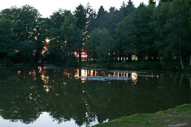
Halfway Pond, located in Sussex, is a picturesque freshwater body encompassing the characteristics of a lake, pool, pond, and freshwater marsh. Spanning approximately 50 acres, the pond is situated halfway between the towns of Eastbourne and Lewes, hence its name.

The pond boasts a diverse ecosystem, making it an ideal habitat for various plant and animal species. Lush vegetation surrounds its banks, including reeds, water lilies, and cattails, providing shelter and food for a multitude of creatures. Bird enthusiasts will find delight in the numerous species that call Halfway Pond home, such as swans, ducks, grebes, and herons. The tranquil waters also attract dragonflies and damselflies, adding to the pond's natural charm.

The water in Halfway Pond remains relatively shallow, with an average depth of around 6 feet. However, it can reach depths of up to 15 feet in some areas. The pond's clear, calm waters make it an inviting spot for recreational activities such as fishing, boating, and kayaking. Anglers can expect to find a variety of fish species, including carp, pike, roach, and tench.

As a designated Site of Special Scientific Interest (SSSI), Halfway Pond is a protected area due to its ecological importance. It serves as a vital breeding ground for several amphibian species, including the great crested newt. The surrounding marshland also provides a haven for rare plants and insects, contributing to the pond's conservation value.

Visitors to Halfway Pond can enjoy its natural beauty while taking advantage of the well-maintained walking trails that wind around its banks. The serene atmosphere and abundance of wildlife make it a popular destination for nature enthusiasts and those seeking a peaceful retreat in the heart of Sussex.

If you have any feedback on the listing, please let us know in the comments section below.

Halfway Pond Images

Images are sourced within 2km of 51.110576/-0.1128624 or Grid Reference TQ3236. Thanks to Geograph Open Source API. All images are credited.

Worth Way Taken from TQ312367 looking south towards where the Worth Way (an old railway line) runs alongside the woodland.
Worth Way
Taken from TQ312367 looking south towards where the Worth Way (an old railway line) runs alongside the woodland.
Turners Hill St Leonard's Church
Turners Hill
St Leonard's Church
The Red Lion at Turners Hill Set back down a side road is this great local with good food and drink. In the winter the logs are always burning. A typical Sussex pub.
The Red Lion at Turners Hill
Set back down a side road is this great local with good food and drink. In the winter the logs are always burning. A typical Sussex pub.
Private Woodland, Worthlodge Forest, Nr Crawley, West Sussex Sussex has a large number of privately owned forests. Worthlodge Forest, part of the Paddockhurst estate, is one of them. Worthlodge has a mixture of coniferous and deciduous trees, grown for timber production and as a home for game birds. Permission is also occasionally obtained to hold orienteering events. The mature woodlands are highly suitable for orienteering and are a favourite venue for local club, Southdowns Orienteers.
Private Woodland, Worthlodge Forest, Nr Crawley, West Sussex
Sussex has a large number of privately owned forests. Worthlodge Forest, part of the Paddockhurst estate, is one of them. Worthlodge has a mixture of coniferous and deciduous trees, grown for timber production and as a home for game birds. Permission is also occasionally obtained to hold orienteering events. The mature woodlands are highly suitable for orienteering and are a favourite venue for local club, Southdowns Orienteers.
Late Spring Meadowland, Tulleys Farm, Nr. Crawley, West Sussex An orienteer battling up hill through a meadow towards the finish of her course during a Southdowns Orienteers event at Tulleys Farm.
Late Spring Meadowland, Tulleys Farm, Nr. Crawley, West Sussex
An orienteer battling up hill through a meadow towards the finish of her course during a Southdowns Orienteers event at Tulleys Farm.
Tulleys Farm - Pick Your Own Strawberries View shows a shed used for weighing customers fruit at this fruit farm. On this particular day (just before the plants were in fruit) the shed is being used for registration and download for a Southdowns Orienteers orienteering event. The strawberries are in the field immediately in front of the shed, and it is just possible to make out the white strawberry flowers on the plants.
Tulleys Farm - Pick Your Own Strawberries
View shows a shed used for weighing customers fruit at this fruit farm. On this particular day (just before the plants were in fruit) the shed is being used for registration and download for a Southdowns Orienteers orienteering event. The strawberries are in the field immediately in front of the shed, and it is just possible to make out the white strawberry flowers on the plants.
Mount Noddy Near to Worth School and Abbey on the main road are these cottages. Local sandstone is used for much of the building in this locality. I wonder why they and the high ground are named Noddy !
Mount Noddy
Near to Worth School and Abbey on the main road are these cottages. Local sandstone is used for much of the building in this locality. I wonder why they and the high ground are named Noddy !
Wallage Lane from Worth Way Taken from the former railway bridge just after the lane has taken a sharp right to go underneath it.
Wallage Lane from Worth Way
Taken from the former railway bridge just after the lane has taken a sharp right to go underneath it.
Mill Pond One of the largest Mill Ponds in the area and used by Copthorne and District Angling Society.   <span class="nowrap"><a title="www.copthorneangling.co.uk" rel="nofollow ugc noopener" href="http://www.copthorneangling.co.uk">Link</a><img style="margin-left:2px;" alt="External link" title="External link - shift click to open in new window" src="https://s1.geograph.org.uk/img/external.png" width="10" height="10"/></span>
Mill Pond
One of the largest Mill Ponds in the area and used by Copthorne and District Angling Society. LinkExternal link
Home Farm , Rowfant A mixed farm with one field devoted to Polo ! See <span class="nowrap"><a title="www.sussexpolo.co.uk" rel="nofollow ugc noopener" href="http://www.sussexpolo.co.uk">Link</a><img style="margin-left:2px;" alt="External link" title="External link - shift click to open in new window" src="https://s1.geograph.org.uk/img/external.png" width="10" height="10"/></span>
Home Farm , Rowfant
A mixed farm with one field devoted to Polo ! See LinkExternal link
Rowfant House The House is now owned by Rowfant House Ltd, a registered charity, which works on behalf of the Latvian Lutheran Church in Great Britain. There is an adjoining residential home for the elderly. The main premises also provides function rooms for lunches and dinners and for business and training purposes. <span class="nowrap"><a title="www.draudze.org.uk/rowfant.htm" rel="nofollow ugc noopener" href="http://www.draudze.org.uk/rowfant.htm">Link</a><img style="margin-left:2px;" alt="External link" title="External link - shift click to open in new window" src="https://s1.geograph.org.uk/img/external.png" width="10" height="10"/></span>
Rowfant House
The House is now owned by Rowfant House Ltd, a registered charity, which works on behalf of the Latvian Lutheran Church in Great Britain. There is an adjoining residential home for the elderly. The main premises also provides function rooms for lunches and dinners and for business and training purposes. LinkExternal link
Tulleys Farm, Turners Hill Tulley’s farm is a prime example of diversification in the agricultural industry. Founded in 1911 It has developed through pick your own in 1971 to its present incarnation as farming theme park with all sorts of family friendly activities to enjoy.  However the roots of business are still firmly planted in food production and sale. For more info see <span class="nowrap"><a title="http://www.tulleysfarm.com/" rel="nofollow ugc noopener" href="http://www.tulleysfarm.com/">Link</a><img style="margin-left:2px;" alt="External link" title="External link - shift click to open in new window" src="https://s1.geograph.org.uk/img/external.png" width="10" height="10"/></span>
Tulleys Farm, Turners Hill
Tulley’s farm is a prime example of diversification in the agricultural industry. Founded in 1911 It has developed through pick your own in 1971 to its present incarnation as farming theme park with all sorts of family friendly activities to enjoy. However the roots of business are still firmly planted in food production and sale. For more info see LinkExternal link
M23 towards London Taken from the bridleway bridge used by the "Worth Way" to cross the motorway. Normally this trail uses the old Three Bridges - East Grinstead railway line, but the motorway severed this route here (at a point roughly where the signs are).
M23 towards London
Taken from the bridleway bridge used by the "Worth Way" to cross the motorway. Normally this trail uses the old Three Bridges - East Grinstead railway line, but the motorway severed this route here (at a point roughly where the signs are).
Done Fishing The fishing lake at <a href="https://www.geograph.org.uk/photo/56328">TQ3237 : Rowfant House</a>, anglers having the last cast before the light goes.
Done Fishing
The fishing lake at TQ3237 : Rowfant House, anglers having the last cast before the light goes.
Rowfant Sunset The fishing lake at <a href="https://www.geograph.org.uk/photo/56328">TQ3237 : Rowfant House</a>
Rowfant Sunset
The fishing lake at TQ3237 : Rowfant House
Labyrinth at Tulleys Farm Unlike the giant Maize Maze at Tulleys Farm <span class="nowrap"><a title="http://www.tulleysfarm.com/" rel="nofollow ugc noopener" href="http://www.tulleysfarm.com/">Link</a><img style="margin-left:2px;" alt="External link" title="External link - shift click to open in new window" src="https://s1.geograph.org.uk/img/external.png" width="10" height="10"/></span> you can't get lost in the labyrinth as there is only one path: follow it to the centre and then on to get out again. Strictly speaking, a labyrinth is not a maze and a maze is not a labyrinth: see the Labyrinthos website <span class="nowrap"><a title="http://www.labyrinthos.net/" rel="nofollow ugc noopener" href="http://www.labyrinthos.net/">Link</a><img style="margin-left:2px;" alt="External link" title="External link - shift click to open in new window" src="https://s1.geograph.org.uk/img/external.png" width="10" height="10"/></span> for more information on labyrinths and mazes.
Labyrinth at Tulleys Farm
Unlike the giant Maize Maze at Tulleys Farm LinkExternal link you can't get lost in the labyrinth as there is only one path: follow it to the centre and then on to get out again. Strictly speaking, a labyrinth is not a maze and a maze is not a labyrinth: see the Labyrinthos website LinkExternal link for more information on labyrinths and mazes.
Tulleys Farm, Turners Hill Great day out for the kids - no entry charge and you can take your own picnic
Tulleys Farm, Turners Hill
Great day out for the kids - no entry charge and you can take your own picnic
Tulleys Farm, Turners Hill Picnic area, self-drive model tractor and open-air cafe - there's a farm shop to the right and an indoor cafe on the left.
Tulleys Farm, Turners Hill
Picnic area, self-drive model tractor and open-air cafe - there's a farm shop to the right and an indoor cafe on the left.
Show me another place!

Halfway Pond is located at Grid Ref: TQ3236 (Lat: 51.110576, Lng: -0.1128624)

Administrative County: West Sussex

District: Mid Sussex

Police Authority: Sussex

What 3 Words

///bombshell.feeds.shipwreck. Near Crawley Down, West Sussex

Related Wikis

Rowfant railway station

Rowfant was a railway station on the Three Bridges to Tunbridge Wells Central Line in the parish of Worth, West Sussex. The line closed in 1967, a casualty...

Tulleys Farm

Tulleys Farm is a fourth-generation family farm, located in West Sussex. Originating in 1937, the farming business at Tulleys was founded by Bernard Beare...

Burgess Hill East (electoral division)

Burgess Hill East is an electoral division of West Sussex in the United Kingdom, and returns one member to sit on West Sussex County Council. == Extent... ==

Turners Hill SSSI

Turners Hill SSSI is a 0.2-hectare (0.49-acre) geological Site of Special Scientific Interest in Turners Hill in West Sussex. It is a Geological Conservation...

St Nicholas Church, Worth

St Nicholas Church is a Church of England parish church in Worth, a village in Crawley, England, which at one time had the largest geographical parish...

Worth Abbey

The Abbey of Our Lady, Help of Christians, commonly known as Worth Abbey, is a community of Roman Catholic monks who follow the Rule of St Benedict near...

Turners Hill

Turners Hill is a village and civil parish in the Mid Sussex District of West Sussex, England. The civil parish covers an area of 1,390 hectares (3,400...

Worth School

Worth School is a private co-educational Roman Catholic boarding and day school for pupils from 11 to 18 years of age near Worth, West Sussex, England...

Related Videos

We Visit The UK's BEST Halloween Attraction? - Tully's Shocktober Fest

We visit our FIRST-ever Scream park! Tulleys Shocktober Fest is Voted The UK's No 1 Halloween Attraction and Europe's largest.

🌻SUNFLOWER FIELD🌻- summer bucket list | Londoner #shortsvideo #londoner

Visit one of London's sunflower fields is definitely something we put on our summer bucket list every year This time we visited ...

Pumpkin everywhere 🎃 🎃 🎃

This is Tulley Pumpkin Farm in Crawley England.Nice fun filled place for children's and families. Good Place for pumpkin patch ...

Nearby Amenities

Located within 500m of 51.110576,-0.1128624
Tulleys Farm
Source: Local Knowledge
Tourism: attraction
Wikidata: Q55636295
Wikipedia: en:Tulleys Farm
Lat/Long: 51.1072855/-0.1111393
Compasses Corner
Naptan AtcoCode: 4400EG0349
Naptan Bearing: SE
Naptan BusStopType: CUS
Naptan CommonName: Compasses Corner
Naptan Indicator: adj Wallage Lane
Naptan Landmark: Wallage Lane
Naptan NaptanCode: wsxapjwp
Naptan Street: Turners Hill Road
Naptan Verified: no
Source: naptan_import
Lat/Long: 51.1130158/-0.1161038
Shop: farm
Lat/Long: 51.1074157/-0.1108957
Bus Stop
Tulleys Farm
Bus: yes
Naptan AtcoCode: 4400EG0382
Naptan Bearing: NW
Naptan CommonName: Tulleys Farm
Naptan Indicator: adj
Naptan Landmark: Tulleys Farm
Naptan NaptanCode: wsxdwpwj
Naptan Street: Major's Hill
Naptan Verified: no
Public Transport: platform
Ref: wsxdwpwj
Shelter: no
Source: naptan_import
Source Date: 2017-08-29T14:31:00
Lat/Long: 51.1074328/-0.1096619
Bus Stop
Tulleys Farm
Bus: yes
Naptan AtcoCode: 4400EG0381
Naptan Bearing: SE
Naptan CommonName: Tulleys Farm
Naptan Indicator: opp
Naptan Landmark: Major's Hill
Naptan NaptanCode: wsxdwpwg
Naptan Street: Turners Hill Road
Naptan Verified: no
Public Transport: platform
Ref: wsxdwpwg
Shelter: no
Source: naptan_import
Source Date: 2017-08-29T14:32:00
Lat/Long: 51.1074558/-0.1094181
Bus Stop
World of Water
Bus: yes
Naptan AtcoCode: 4400EG0379
Naptan Bearing: SE
Naptan CommonName: World of Water
Naptan Indicator: opp
Naptan NaptanCode: wsxdwpwa
Naptan Street: Turners Hill Road
Naptan Verified: no
Public Transport: platform
Lat/Long: 51.1104119/-0.1127515
Bus Stop
World of Water
Bus: yes
Naptan AtcoCode: 4400EG0380
Naptan Bearing: NW
Naptan CommonName: World of Water
Naptan Indicator: adj
Naptan NaptanCode: wsxdwpwd
Naptan Street: Turners Hill Road
Naptan Verified: no
Public Transport: platform
Lat/Long: 51.1100422/-0.1126362
Addr City: Crawley
Addr Housename: The Spiral
Addr Street: Turners Hill Road
Building: house
Building Levels: 1
Lat/Long: 51.1120978/-0.1138288
Addr Housename: Worth Hall Lodge
Building: house
Lat/Long: 51.1130028/-0.1168134
The data included in this document is from www.openstreetmap.org. The data is made available under ODbL.

Have you been to Halfway Pond?

Leave your review of Halfway Pond below (or comments, questions and feedback).