Seven Post Pond

Lake, Pool, Pond, Freshwater Marsh in Surrey

England

Seven Post Pond

Scio Pond Had I arrived a couple of minutes previously, I might have photographed a kingfisher sitting on this sign. At least I managed a distant photograph, a few minutes later.
Scio Pond Credit: Peter Trimming

Seven Post Pond, located in Surrey, is a picturesque freshwater ecosystem that serves as a vital habitat for a diverse range of plant and animal species. Spanning an area of approximately 30 acres, the pond presents a harmonious blend of a lake, pool, pond, and freshwater marsh, making it a unique natural feature in the region.

The pond is surrounded by lush vegetation, including towering trees, shrubs, and aquatic plants that provide ample shade and shelter for the various inhabitants. Its tranquil waters are home to numerous fish species, such as bass, trout, and perch, which attract anglers from across the county. These fish contribute to the pond's ecological balance, feeding on smaller organisms and serving as a food source for larger predators.

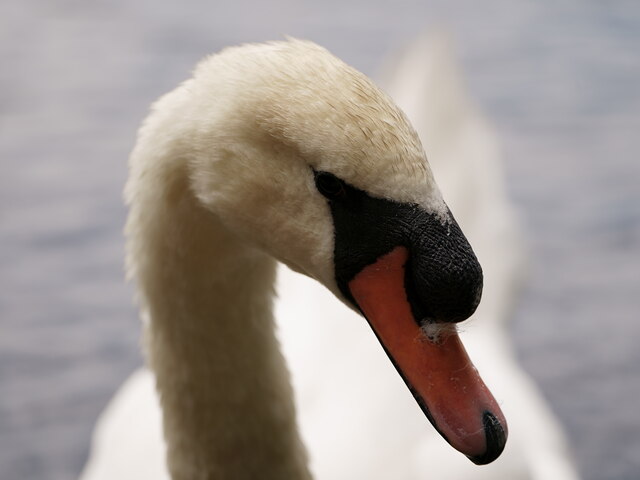
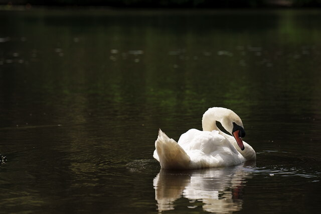
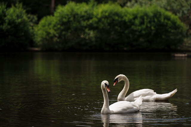
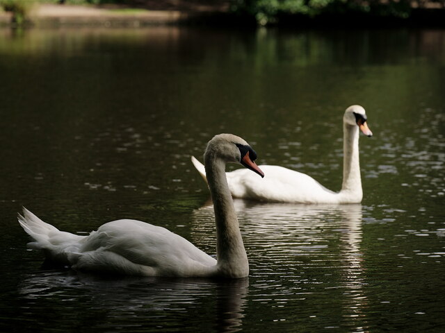
The diverse birdlife around Seven Post Pond is a sight to behold. Visitors can often spot graceful herons, vibrant kingfishers, and elegant swans gliding across the calm waters. The surrounding marshland provides a nesting ground for waterfowl, including ducks and geese, while the reeds and grasses offer a haven for smaller birds, such as warblers and finches.

The pond not only supports aquatic life but also serves as a recreational area for locals and tourists alike. Its clear waters invite swimmers during the summer months, and boating enthusiasts can be seen rowing or paddling across the pond's surface. Additionally, the well-maintained walking trails that encircle the pond attract nature lovers and hikers, providing an opportunity to observe the diverse flora and fauna that call Seven Post Pond their home.

Overall, Seven Post Pond is a natural gem in Surrey, offering a harmonious blend of aquatic life, lush vegetation, and recreational opportunities for all to enjoy.

If you have any feedback on the listing, please let us know in the comments section below.

Seven Post Pond Images

Images are sourced within 2km of 51.445257/-0.22289914 or Grid Reference TQ2373. Thanks to Geograph Open Source API. All images are credited.

Scio Pond Had I arrived a couple of minutes previously, I might have photographed a kingfisher sitting on this sign. At least I managed a distant photograph, a few minutes later.
Scio Pond
Had I arrived a couple of minutes previously, I might have photographed a kingfisher sitting on this sign. At least I managed a distant photograph, a few minutes later.
Scio Pond A kingfisher, at the western edge of the pond.
Scio Pond
A kingfisher, at the western edge of the pond.
View over Putney Vale Cemetery Putney Vale Cemetery viewed from the edge of Wimbledon Common.
View over Putney Vale Cemetery
Putney Vale Cemetery viewed from the edge of Wimbledon Common.
Whitelands College A natural view into the Richmond Park from University of Roehampton, Whitelands College.
Whitelands College
A natural view into the Richmond Park from University of Roehampton, Whitelands College.
St Joseph's Catholic Church, by the T Junction
Roehampton village Teddy bear treasure hunt
Roehampton village
Teddy bear treasure hunt
St Mary's rd
St Mary's rd
The Windmill on Wimbledon Common This windmill is a Grade II* listed building.  It was built in 1816 by Charles March, a Roehampton carpenter.  These days it houses a museum of windmills and a cafe.
The Windmill on Wimbledon Common
This windmill is a Grade II* listed building. It was built in 1816 by Charles March, a Roehampton carpenter. These days it houses a museum of windmills and a cafe.
Wimbledon Common Swans on Queen's Mere. Having packed away my camera, I realised that I have been spotted and that the swans were coming to see me.

The swans bred in 2022, but only produced two cygnets. One was reportedly taken by a pike but the fate of the second was unknown.
Wimbledon Common
Swans on Queen's Mere. Having packed away my camera, I realised that I have been spotted and that the swans were coming to see me. The swans bred in 2022, but only produced two cygnets. One was reportedly taken by a pike but the fate of the second was unknown.
Wimbledon Common One of the swans on Queen's Mere.
Wimbledon Common
One of the swans on Queen's Mere.
Wimbledon Common One of the swans on Queen's Mere.
Wimbledon Common
One of the swans on Queen's Mere.
Wimbledon Common One of the swans on Queen's Mere.
Wimbledon Common
One of the swans on Queen's Mere.
Wimbledon Common Swans on Queen's Mere.
Wimbledon Common
Swans on Queen's Mere.
Wimbledon Common Swans on Queen's Mere.
Wimbledon Common
Swans on Queen's Mere.
Wimbledon Common Swans on Queen's Mere.
Wimbledon Common
Swans on Queen's Mere.
Wimbledon Common Swans on Queen's Mere.
Wimbledon Common
Swans on Queen's Mere.
Wimbledon Common Swans on Queen's Mere.
Wimbledon Common
Swans on Queen's Mere.
Mayfield Road closed for the Tennis Mayfield Road is only  open for residents and permit holders for the duration of the Wimbledon Tennis championships, with The City in the background.
Mayfield Road closed for the Tennis
Mayfield Road is only open for residents and permit holders for the duration of the Wimbledon Tennis championships, with The City in the background.
Show me another place!

Seven Post Pond is located at Grid Ref: TQ2373 (Lat: 51.445257, Lng: -0.22289914)

Unitary Authority: Wandsworth

Police Authority: Metropolitan

What 3 Words

///lion.beans.rated. Near Wandsworth, London

Related Wikis

Wildcroft Manor

Wildcroft Manor is a historic site in Putney in the London Borough of Wandsworth, with private housing and a Grade II Listed iron gateway. == Location... ==

The Wimbledon Synagogue

The Wimbledon Synagogue (formally, Wimbledon and District Synagogue), a member of the Movement for Reform Judaism, is a synagogue in the London Borough...

Scio House Hospital

Scio House Hospital for Officers was a hospital catering for military officers in Putney, London. == History == Scio House was the last villa on Portsmouth...

Linden Lodge School

Linden Lodge School for the Blind is a specialist sensory and physical college located in Wimbledon, South London, England. It educates visually impaired...

Nearby Amenities

Located within 500m of 51.445257,-0.22289914
Motorway Junction
Tibbet's Corner
Lat/Long: 51.4467807/-0.2268358
Give Way
Direction: forward
Lat/Long: 51.4434812/-0.2174583
Mini Roundabout
Direction: clockwise
Lat/Long: 51.443511/-0.2173312
Ref GB Tflcid: RWG088345
Traffic Calming: hump
Lat/Long: 51.4473749/-0.2202945
Give Way
Direction: forward
Lat/Long: 51.4435727/-0.2173369
Ref GB Tflcid: RWG087986
Traffic Calming: hump
Lat/Long: 51.4460095/-0.218826
Post Box
Operator: Royal Mail
Operator Wikidata: Q638098
Ref: SW19 105
Lat/Long: 51.4469211/-0.2176607
Post Box
Operator: Royal Mail
Operator Wikidata: Q638098
Ref: SW19 20
Lat/Long: 51.4451341/-0.222412
Post Box
Operator: Royal Mail
Operator Wikidata: Q638098
Ref: SW19 7
Lat/Long: 51.443607/-0.2173222
Post Box
Operator: Royal Mail
Operator Wikidata: Q638098
Ref: SW19 5
Lat/Long: 51.4409723/-0.221313
Bus Stop
Albemarle
Bench: yes
Bin: yes
Bus: yes
Local Ref: PX
Naptan AtcoCode: 490003146N
Naptan Bearing: N
Naptan CommonName: Albemarle
Naptan Indicator: Stop PX
Public Transport: platform
Ref: 54726
Shelter: yes
Source Ref: naptan
Tactile Paving: no
Lat/Long: 51.4427393/-0.2234058
Bus Stop
Albemarle
Bus: yes
Local Ref: PF
Naptan AtcoCode: 490003146S
Naptan Bearing: S
Naptan CommonName: Albemarle
Naptan Indicator: Stop PF
Public Transport: platform
Ref: 53011
Source Ref: naptan
Lat/Long: 51.4421227/-0.2234122
Bus Stop
Windlesham Grove
Bus: yes
Local Ref: PN
Naptan AtcoCode: 490004595S
Naptan Bearing: S
Naptan CommonName: Windlesham Grove Burleigh Ct
Naptan Indicator: Stop PN
Naptan Street: PRINCES WAY
Public Transport: platform
Ref: 57570
Source Ref: naptan
Lat/Long: 51.4466933/-0.2163849
Bus Stop
Keevil Drive
Bus: yes
Local Ref: PS
Naptan AtcoCode: 490008565N
Naptan Bearing: N
Naptan CommonName: John Paul II School
Naptan Indicator: Stop PS
Naptan Street: PRINCES WAY
Public Transport: platform
Ref: 56608
Source Ref: naptan
Lat/Long: 51.4484401/-0.2192087
Bus Stop
Keevil Drive
Bus: yes
Local Ref: PM
Naptan AtcoCode: 490008565S
Naptan Bearing: S
Naptan CommonName: John Paul II School
Naptan Indicator: Stop PM
Naptan Street: PRINCES WAY
Public Transport: platform
Ref: 73502
Source Ref: naptan
Lat/Long: 51.4477533/-0.2178465
Bus Stop
Inner Park Road
Bus: yes
Local Ref: PE
Naptan AtcoCode: 490008489S
Naptan Bearing: S
Naptan CommonName: Inner Park Road
Naptan Indicator: Stop PE
Public Transport: platform
Ref: 75766
Source Ref: naptan
Lat/Long: 51.4445936/-0.2226884
Bus Stop
Levana Close
Bench: yes
Bus: yes
Naptan AtcoCode: 490009097N
Naptan Bearing: N
Naptan CommonName: Levana Close
Naptan Street: VICTORIA DRIVE
Naptan Verified: no
Public Transport: platform
Ref: 56907
Source Ref: naptan
Lat/Long: 51.4428184/-0.2172154
Bus Stop
Levana Close
Bus: yes
Naptan AtcoCode: 490009097S
Naptan Bearing: N
Naptan CommonName: Levana Close
Naptan Street: VICTORIA DRIVE
Naptan Verified: no
Public Transport: platform
Ref: 91546
Source Ref: naptan
Lat/Long: 51.4433771/-0.2171793
Bus Stop
Tibbet's Corner
Bench: yes
Bin: yes
Bus: yes
Local Ref: PK
Naptan AtcoCode: 490013662N1
Naptan Bearing: N
Naptan CommonName: Tibbet's Corner
Naptan Indicator: Stop PK
Public Transport: platform
Ref: 74688
Shelter: yes
Source Ref: naptan
Tactile Paving: no
Wheelchair: yes
Lat/Long: 51.4459592/-0.2224632
Bus Stop
Tibbet's Corner
Bench: yes
Bin: no
Bus: yes
Local Ref: PD
Naptan AtcoCode: 490013662S1
Naptan Bearing: S
Naptan CommonName: Tibbet's Corner
Naptan Indicator: Stop PD
Naptan Street: WIMBLEDON PARKSIDE
Public Transport: platform
Ref: 73167
Shelter: yes
Source Ref: naptan
Tactile Paving: no
Wheelchair: yes
Lat/Long: 51.4461154/-0.222237
Bus Stop
Tibbet's Corner
Bench: yes
Bin: no
Bus: yes
Lit: yes
Local Ref: PR
Naptan AtcoCode: 490013662S2
Naptan Bearing: S
Naptan CommonName: Tibbet's Corner
Naptan Indicator: Stop PR
Naptan Street: WEST HILL
Public Transport: platform
Ref: 58423
Shelter: yes
Source Ref: naptan
Tactile Paving: yes
Lat/Long: 51.4487149/-0.2215366
Bus Stop
Windlesham Grove
Bus: yes
Naptan AtcoCode: 490014758N
Naptan Bearing: N
Naptan CommonName: Windlesham Grove Princes Way
Naptan Street: PRINCES WAY
Public Transport: platform
Ref: 57049
Source Ref: naptan
Lat/Long: 51.4461474/-0.2159732
Bus Stop
Withycombe Road
Bus: yes
Local Ref: PL
Naptan AtcoCode: 490014796N
Naptan Bearing: N
Naptan CommonName: Withycombe Road
Naptan Indicator: Stop PL
Naptan Street: WITHYCOMBE ROAD
Public Transport: platform
Ref: 71871
Shelter: yes
Source Ref: naptan
Lat/Long: 51.4482353/-0.2217694
Bus Stop
Withycombe Road
Bus: yes
Local Ref: PT
Naptan AtcoCode: 490014796S
Naptan Bearing: S
Naptan CommonName: Withycombe Road
Naptan Indicator: Stop PT
Naptan Street: WITHYCOMBE ROAD
Public Transport: platform
Ref: 53974
Source Ref: naptan
Lat/Long: 51.4479535/-0.2216726
Bus Stop
Tibbet's Corner
Bus: yes
Local Ref: PC
Naptan AtcoCode: 490015450E
Naptan Bearing: E
Naptan CommonName: Tibbets Ride Tibbet's Corner
Naptan Indicator: Stop PC
Public Transport: platform
Shelter: yes
Lat/Long: 51.449163/-0.221441
Bus Stop
Tibbet's Ride
Bench: yes
Bin: no
Bus: yes
Lit: yes
Local Ref: PW
Naptan AtcoCode: 490015450N
Naptan Bearing: N
Naptan CommonName: Tibbets Ride Tibbet's Corner
Naptan Indicator: Stop PW
Public Transport: platform
Shelter: yes
Tactile Paving: yes
Lat/Long: 51.449396/-0.2230339
Barrier: bollard
Lat/Long: 51.4491342/-0.2207603
Recycling
Lat/Long: 51.4486183/-0.2252682
Barrier: bollard
Lat/Long: 51.44807/-0.2220557
Motorway Junction
Tibbet's Corner
Lat/Long: 51.4493414/-0.2206138
Give Way
Direction: backward
Lat/Long: 51.4435268/-0.2172121
Turning Circle
Lat/Long: 51.4419961/-0.2223737
Give Way
Direction: backward
Lat/Long: 51.4434421/-0.2172897
Traffic Calming: bump
Lat/Long: 51.447717/-0.2179232
Traffic Calming: bump
Lat/Long: 51.4471488/-0.2171876
The Co-operative Food
Addr City: London
Addr Housenumber: 90
Addr Postcode: SW19 6DA
Addr Street: Inner Park Road
Brand: The Co-operative Food
Brand Wikidata: Q107617274
Fhrs Id: 1572256
Operator: The Co-operative Group
Operator Wikidata: Q117202
Shop: convenience
Source Addr: FHRS Open Data
Website: https://www.coop.co.uk/store-finder/SW19-6DA/90-inner-park-road
Lat/Long: 51.4409993/-0.22185
Hartley's Obelisk
Historic: memorial
Wikidata: Q26318606
Lat/Long: 51.4476931/-0.2252126
Ref GB Tflcid: RWG088348
Traffic Calming: cushion
Lat/Long: 51.4481869/-0.2185763
Barrier: bollard
Lat/Long: 51.4492988/-0.221201
Crossing
Crossing: uncontrolled
Crossing Ref: zebra
Lat/Long: 51.4468245/-0.217655
Londis
Addr City: London
Addr Housenumber: 4-8
Addr Postcode: SW19 6QL
Addr Street: Montfort Place
Brand: Londis
Brand Wikidata: Q21008564
Brand Wikipedia: en:Londis (United Kingdom)
Fhrs Id: 1571546
Operator: Londis
Shop: convenience
Source Addr: FHRS Open Data
Lat/Long: 51.4469793/-0.2177198
Best One
Addr City: London
Addr Housename: Princes Way Post Office Shop And Premises
Addr Housenumber: 2A
Addr Postcode: SW19 6QL
Addr Street: Montfort Place
Fhrs Id: 1571766
Opening Hours: Mo-Sa 08:00-21:00, Su 08:00-17:00
Shop: supermarket
Source Addr: FHRS Open Data
Lat/Long: 51.4470638/-0.2174764
Bicycle Parking
Lat/Long: 51.4488643/-0.2262532
Crossing
Crossing: traffic_signals
Lat/Long: 51.4454404/-0.2225226
Crossing
Bicycle: yes
Crossing: unmarked
Crossing Markings: no
Lat/Long: 51.4473213/-0.2220153
Crossing
Bicycle: yes
Crossing: unmarked
Crossing Markings: no
Lat/Long: 51.447173/-0.2220506
Crossing
Bicycle: yes
Crossing: unmarked
Crossing Markings: no
Lat/Long: 51.4471594/-0.2221993
Crossing
Crossing: unmarked
Crossing Markings: no
Lat/Long: 51.4473863/-0.2220431
Turning Circle
Lat/Long: 51.4494851/-0.2210341
Barrier: bollard
Lat/Long: 51.4491385/-0.2215315
Barrier: bollard
Lat/Long: 51.4493215/-0.2213249
Barrier: cycle_barrier
Lat/Long: 51.4484382/-0.2181025
Turning Circle
Lat/Long: 51.4473753/-0.2287679
Crossing
Crossing: unmarked
Crossing Island: yes
Lat/Long: 51.4487158/-0.2214224
Barrier: bollard
Bollard: fixed
Lat/Long: 51.4485898/-0.2216716
Barrier: bollard
Lat/Long: 51.4486528/-0.2227179
Barrier: bollard
Lat/Long: 51.4481634/-0.2224847
Barrier: bollard
Lat/Long: 51.4489536/-0.2234061
Give Way
Direction: backward
Lat/Long: 51.4487908/-0.2211725
Give Way
Direction: forward
Lat/Long: 51.4487678/-0.2198442
Give Way
Direction: backward
Lat/Long: 51.4480686/-0.2183481
Give Way
Direction: backward
Lat/Long: 51.4470639/-0.2171307
Traffic Calming: bump
Lat/Long: 51.446486/-0.2162438
Edwin Saunders
Historic: memorial
Inscription: Sir Edwin Saunders (1814-1901) Dentist to Queen Victoria lived and died here
Memorial: blue_plaque
Openplaques Id: 228
Subject Wikidata: Q17479471
Lat/Long: 51.4463967/-0.2221523
Barrier: bollard
Lat/Long: 51.4481721/-0.2198159
Traffic Calming: bump
Lat/Long: 51.4471555/-0.2289336
Traffic Calming: bump
Lat/Long: 51.4471925/-0.2285185
Traffic Calming: bump
Lat/Long: 51.4474464/-0.2284057
Traffic Calming: bump
Lat/Long: 51.4479522/-0.2284102
Traffic Calming: bump
Lat/Long: 51.4487992/-0.2271628
Traffic Calming: cushion
Lat/Long: 51.448848/-0.2201908
Traffic Calming: hump
Lat/Long: 51.4485786/-0.2210333
Give Way
Direction: backward
Lat/Long: 51.4458752/-0.2192666
Give Way
Direction: forward
Lat/Long: 51.4459001/-0.2191921
Give Way
Direction: backward
Lat/Long: 51.4450373/-0.2184962
Traffic Calming: hump
Lat/Long: 51.4440288/-0.2176918
DC candy
Tourism: apartment
Lat/Long: 51.4420573/-0.2231116
Ref GB Tflcid: RWG088570
Traffic Calming: hump
Lat/Long: 51.4446722/-0.2182388
Ref GB Tflcid: RWG088494
Traffic Calming: cushion
Lat/Long: 51.4430394/-0.2171959
Ref GB Tflcid: RWG108875;RWG087989
Traffic Calming: hump
Lat/Long: 51.4468901/-0.2199491
Ref GB Tflcid: RWG087985
Traffic Calming: hump
Lat/Long: 51.44543/-0.2188669
Ref GB Tflcid: RWG087988
Traffic Calming: hump
Lat/Long: 51.4461468/-0.2194133
Ref GB Tflcid: RWG088518
Traffic Calming: hump
Lat/Long: 51.4461437/-0.2178222
Bicycle Parking
Bicycle Lock: provided
Bicycle Parking: upright_stands
Capacity: 6
Covered: yes
Ref GB Tflcid: RWG082864
Lat/Long: 51.4485615/-0.2180644
The data included in this document is from www.openstreetmap.org. The data is made available under ODbL.

Have you been to Seven Post Pond?

Leave your review of Seven Post Pond below (or comments, questions and feedback).