Bushey Pond

Lake, Pool, Pond, Freshwater Marsh in Hertfordshire Hertsmere

England

Bushey Pond

Information Board at west end of Oxhey Park This information board erected by Watford Borough Council, is by the River Colne in Wiggenhall Road. It shows a map of the park with the following wording above it:
              Welcome to Oxhey Park

  Points of Interest (in blue)
  1) River Colne
  2) The Dell
  3) The Terrace
  4) Grand Steps
  5) Art Piece (Conker Sculpture)
  6) Art Piece (Carved Oak Seat)
 
  Facilities (in red)
  1) Children's Play Area
  2) 'Kick About' Area
  3) Cycle Route
  4) Seating Areas
  5) Outdoor Gym
  6) Picnic Area

 Below the map is detailed information on
 i) Oxhey Park
 ii) How Oxhey Park came to be
 iii) Places of interest
 iv) Oxhey Park Refurbishment
 v) Art  in the Park

 Below that detailed information panel is a panel with the 
 following road signs from left to right:
 i) No Dropping Litter
 ii) No Dog Fouling
 iii) No Fires or Barbecues
 iv) No  Golf
 v) Do not pick the flowers or plants

 There is another identical information board at the east end of Oxhey Park near
 Bushey Arches, and two similar boards at the entrances to Oxhey Park in 
 Eastbury Road.
Information Board at west end of Oxhey Park Credit: David Hillas

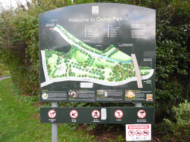
Bushey Pond, located in Hertfordshire, England, is a picturesque freshwater marsh that serves as an important natural habitat and recreational area. With an area of approximately 10 acres, it offers a serene and tranquil environment for visitors to enjoy.

The pond is surrounded by lush vegetation, including reeds and water lilies, which provide shelter and food for a diverse range of wildlife. Visitors can expect to spot various bird species, such as ducks, swans, and herons, as well as amphibians like frogs and newts. The surrounding trees and shrubs attract small mammals, including squirrels and hedgehogs.

Bushey Pond is a popular spot for walking, jogging, and picnicking, with well-maintained pathways that allow visitors to explore its beautiful surroundings. The pond also offers fishing opportunities, with a variety of freshwater fish, such as carp and perch, inhabiting its waters.

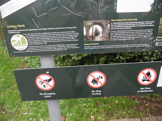
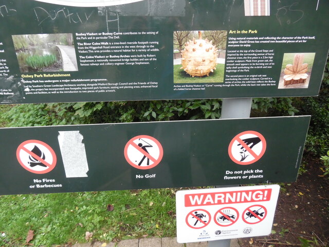
In addition to its natural beauty, Bushey Pond has a rich history. It was originally created in the 17th century to provide water for a nearby mill. Over the years, it has become an integral part of the local community, offering a peaceful retreat from the bustling city life.

The pond is easily accessible, with parking facilities available nearby. It is also conveniently located close to amenities, including cafes and shops, making it an ideal destination for a day trip or a leisurely stroll.

Overall, Bushey Pond in Hertfordshire is a captivating and tranquil freshwater marsh that offers both natural beauty and recreational opportunities for visitors to enjoy.

If you have any feedback on the listing, please let us know in the comments section below.

Bushey Pond Images

Images are sourced within 2km of 51.644875/-0.36758916 or Grid Reference TQ1395. Thanks to Geograph Open Source API. All images are credited.

Information Board at west end of Oxhey Park This information board erected by Watford Borough Council, is by the River Colne in Wiggenhall Road. It shows a map of the park with the following wording above it:
              Welcome to Oxhey Park

  Points of Interest (in blue)
  1) River Colne
  2) The Dell
  3) The Terrace
  4) Grand Steps
  5) Art Piece (Conker Sculpture)
  6) Art Piece (Carved Oak Seat)
 
  Facilities (in red)
  1) Children's Play Area
  2) 'Kick About' Area
  3) Cycle Route
  4) Seating Areas
  5) Outdoor Gym
  6) Picnic Area

 Below the map is detailed information on
 i) Oxhey Park
 ii) How Oxhey Park came to be
 iii) Places of interest
 iv) Oxhey Park Refurbishment
 v) Art  in the Park

 Below that detailed information panel is a panel with the 
 following road signs from left to right:
 i) No Dropping Litter
 ii) No Dog Fouling
 iii) No Fires or Barbecues
 iv) No  Golf
 v) Do not pick the flowers or plants

 There is another identical information board at the east end of Oxhey Park near
 Bushey Arches, and two similar boards at the entrances to Oxhey Park in 
 Eastbury Road.
Information Board at west end of Oxhey Park
This information board erected by Watford Borough Council, is by the River Colne in Wiggenhall Road. It shows a map of the park with the following wording above it: Welcome to Oxhey Park Points of Interest (in blue) 1) River Colne 2) The Dell 3) The Terrace 4) Grand Steps 5) Art Piece (Conker Sculpture) 6) Art Piece (Carved Oak Seat) Facilities (in red) 1) Children's Play Area 2) 'Kick About' Area 3) Cycle Route 4) Seating Areas 5) Outdoor Gym 6) Picnic Area Below the map is detailed information on i) Oxhey Park ii) How Oxhey Park came to be iii) Places of interest iv) Oxhey Park Refurbishment v) Art in the Park Below that detailed information panel is a panel with the following road signs from left to right: i) No Dropping Litter ii) No Dog Fouling iii) No Fires or Barbecues iv) No Golf v) Do not pick the flowers or plants There is another identical information board at the east end of Oxhey Park near Bushey Arches, and two similar boards at the entrances to Oxhey Park in Eastbury Road.
Detailed Information on the Information Board at Oxhey Park (1) This photo shows detailed information below the map on the Information Board in 
 Wiggenhall Road. It has the following wording:

 Oxhey Park
 Oxhey Park is situated on land originally part of the Wiggen Hall Estate, with 
 a history which goes back hundreds of years.
 In the 15th Century the manor of Wiggenhall cum Oxhey was owned by St Alban's 
 Abbey (now Cathedral). After the dissolution of the Church during the reign of
 Henry VIII the land then passed to private ownership. During the 16th and 17th
 Centuries Sir William Bucknall and his heirs owned the Oxhey/Wiggen Hall Estate
 (living at Oxhey Place). Wiggen Hall Manor was leased to the Deacon family who
 lived there until the mid-19th Century. In 1826 Wiggen Hall and the Estate were
 bought by Jonathon King passing to his nephew Joseph Gutteridge Smith in 1881.
 Ordnance Survey records from the 1870s show the Wiggen Hall as a large country
 house overlooking the River Colne, with elaborate gardens, a walled garden,
 woodland pleasure grounds and landscaped parklands. During World War I a large
 proportion of the land was requisitioned for food production. By 1929 Wiggen 
 Hall was unoccupied and then eventually demolished in 1955.

 How Oxhey Park came to be
 In 1920 Watford Borough Council (with help from a Government Grant) bought 85
 acres of the Estate for £14,000 in order that they could build a housing
 development and provide recreational space for the local community.
 In January 1924 the Estates Committee at the Council recommended that the newly
 allocated public park be known as Oxhey Park. In the 1920s, as now, a walk 
 along the river was one of the main attractions of the park. By the 1930s
 refreshments were being sold from a boathouse to the north of the River Colne
 and fishing, boating and swimming were all allowed. The first children's
 playground was built in 1930.
 
 The two images show the Colne Viaduct or Bushey Arches.
Detailed Information on the Information Board at Oxhey Park (1)
This photo shows detailed information below the map on the Information Board in Wiggenhall Road. It has the following wording: Oxhey Park Oxhey Park is situated on land originally part of the Wiggen Hall Estate, with a history which goes back hundreds of years. In the 15th Century the manor of Wiggenhall cum Oxhey was owned by St Alban's Abbey (now Cathedral). After the dissolution of the Church during the reign of Henry VIII the land then passed to private ownership. During the 16th and 17th Centuries Sir William Bucknall and his heirs owned the Oxhey/Wiggen Hall Estate (living at Oxhey Place). Wiggen Hall Manor was leased to the Deacon family who lived there until the mid-19th Century. In 1826 Wiggen Hall and the Estate were bought by Jonathon King passing to his nephew Joseph Gutteridge Smith in 1881. Ordnance Survey records from the 1870s show the Wiggen Hall as a large country house overlooking the River Colne, with elaborate gardens, a walled garden, woodland pleasure grounds and landscaped parklands. During World War I a large proportion of the land was requisitioned for food production. By 1929 Wiggen Hall was unoccupied and then eventually demolished in 1955. How Oxhey Park came to be In 1920 Watford Borough Council (with help from a Government Grant) bought 85 acres of the Estate for £14,000 in order that they could build a housing development and provide recreational space for the local community. In January 1924 the Estates Committee at the Council recommended that the newly allocated public park be known as Oxhey Park. In the 1920s, as now, a walk along the river was one of the main attractions of the park. By the 1930s refreshments were being sold from a boathouse to the north of the River Colne and fishing, boating and swimming were all allowed. The first children's playground was built in 1930. The two images show the Colne Viaduct or Bushey Arches.
Detailed Information on the Information Board at Oxhey Park (2) This photo shows detailed information below the map on the information board in Wiggenhall Road. It has the following wording:

 Places of interest
 The Dell is a densely wooded area with steep banks falling away from the 
 Eastbury Road down to the River Colne. Its distinct woodland character provides 
 an ideal home for a variety of wildlife. Built in 1912, the magnificent LMS 
 Bushey Viaduct or Bushey Curve contributes to the setting of the Park and in 
 particular The Dell.
 The River Colne Walk is a tree-lined riverside footpath running from the
 Wiggenhall Road entrance in the west through to the Viaduct. This area provides
 a natural habitat for a variety of wildlife.
 The Colne Viaduct or Bushey Arches were built by Robert Stephenson, a 
 nationally renowned bridge builder, and son of the famous railways and colliery
 engineer George Stephenson.
 Image of the River Colne Walk

 Oxhey Park Refurbishment
 Oxhey park has undergone a major refurbishment programme.
 Led by Southern Green Landscape Architects working alongside Watford Borough
 Council and the Friends of Oxhey Park, the project has incorporated new
 footpaths, improved park furniture, seating and planting areas, enhanced focal
 points and facilities, as well as the introduction to two pieces of public
 artwork.

 Art in the Park
 Using natural materials and reflecting the character of the Park itself,
 sculptor David Gross has created two beautiful pieces of art for everyone to 
 enjoy.
 Located at the top of the Grand Steps and inspired by the surrounding avenue of
 horse chestnut trees, the first piece is a 2.5m high conker sculpture. Made 
 from green oak, the smooth seed appears to be bursting out of its spiky shell
 symbolising the re-birth and new beginnings of the Park.
 The second piece is an original oak seat overlooking the conker sculpture.
 Carved in a series of arches, the solid base reflects the Bushey Arches and 
 Bushey Viaduct or "Curve" running through the Park, whilst the back rest takes
 the form of a folded horse chestnut leaf.
 Images of the conker and oak seat sculptures.
Detailed Information on the Information Board at Oxhey Park (2)
This photo shows detailed information below the map on the information board in Wiggenhall Road. It has the following wording: Places of interest The Dell is a densely wooded area with steep banks falling away from the Eastbury Road down to the River Colne. Its distinct woodland character provides an ideal home for a variety of wildlife. Built in 1912, the magnificent LMS Bushey Viaduct or Bushey Curve contributes to the setting of the Park and in particular The Dell. The River Colne Walk is a tree-lined riverside footpath running from the Wiggenhall Road entrance in the west through to the Viaduct. This area provides a natural habitat for a variety of wildlife. The Colne Viaduct or Bushey Arches were built by Robert Stephenson, a nationally renowned bridge builder, and son of the famous railways and colliery engineer George Stephenson. Image of the River Colne Walk Oxhey Park Refurbishment Oxhey park has undergone a major refurbishment programme. Led by Southern Green Landscape Architects working alongside Watford Borough Council and the Friends of Oxhey Park, the project has incorporated new footpaths, improved park furniture, seating and planting areas, enhanced focal points and facilities, as well as the introduction to two pieces of public artwork. Art in the Park Using natural materials and reflecting the character of the Park itself, sculptor David Gross has created two beautiful pieces of art for everyone to enjoy. Located at the top of the Grand Steps and inspired by the surrounding avenue of horse chestnut trees, the first piece is a 2.5m high conker sculpture. Made from green oak, the smooth seed appears to be bursting out of its spiky shell symbolising the re-birth and new beginnings of the Park. The second piece is an original oak seat overlooking the conker sculpture. Carved in a series of arches, the solid base reflects the Bushey Arches and Bushey Viaduct or "Curve" running through the Park, whilst the back rest takes the form of a folded horse chestnut leaf. Images of the conker and oak seat sculptures.
The Mercure Hotel, Watford
Carpenders Avenue, Carpenders Park Carpenders Park is very much an outer London suburb although it is situated outside the Greater London area. The development took place either side of the Second World War and the housing is typical of its time including a significant number of bungalows. The name is derived from a local manor house that was demolished in 1960 but has perhaps survived because it was given to the nearby railway station.
Carpenders Avenue, Carpenders Park
Carpenders Park is very much an outer London suburb although it is situated outside the Greater London area. The development took place either side of the Second World War and the housing is typical of its time including a significant number of bungalows. The name is derived from a local manor house that was demolished in 1960 but has perhaps survived because it was given to the nearby railway station.
Path to The Mead, Carpenders Park Designated a public footpath, and signed accordingly, this route cuts through between the houses on Carpenders Avenue and The Mead at the bottom.
Path to The Mead, Carpenders Park
Designated a public footpath, and signed accordingly, this route cuts through between the houses on Carpenders Avenue and The Mead at the bottom.
Old Boundary Marker on the A411 Lower High Street, Watford Turnpike Terminus Marker on the northeast side of the A411 Lower High Street in Watford. In raised lettering SPARROWS / HERNE / TRUST. See <span class="nowrap"><a title="https://en.wikipedia.org/wiki/Sparrows_Herne_Turnpike_Road" rel="nofollow ugc noopener" href="https://en.wikipedia.org/wiki/Sparrows_Herne_Turnpike_Road">Link</a><img style="margin-left:2px;" alt="External link" title="External link - shift click to open in new window" src="https://s1.geograph.org.uk/img/external.png" width="10" height="10"/></span>. Grade II Listed details <span class="nowrap"><a title="https://historicengland.org.uk/listing/the-list/list-entry/1250997" rel="nofollow ugc noopener" href="https://historicengland.org.uk/listing/the-list/list-entry/1250997">Link</a><img style="margin-left:2px;" alt="External link" title="External link - shift click to open in new window" src="https://s1.geograph.org.uk/img/external.png" width="10" height="10"/></span>. See also <a title="https://www.geograph.org.uk/photo/4803063" href="https://www.geograph.org.uk/photo/4803063">Link</a>.

Milestone Society National ID: HE_WFSHt
Old Boundary Marker on the A411 Lower High Street, Watford
Turnpike Terminus Marker on the northeast side of the A411 Lower High Street in Watford. In raised lettering SPARROWS / HERNE / TRUST. See LinkExternal link. Grade II Listed details LinkExternal link. See also Link. Milestone Society National ID: HE_WFSHt
Shops on High Road
Shops on High Road
Church of St Peter, Bushey Heath
The Three Crowns
The Three Crowns
C. Loveday & Son bakery, Villers Road, Oxhey, Watford
Bushey railway station, Pinner Road
Bushey and Oxhey Methodist Church, Chalk Hill
Bushey & Oxhey Methodist Church, Chalk Hill
Bushey Baptist Church, Chalk Hill
Chapel, St Margaret's School, Merry Hill Road
Watford Pump House Theatre, Local Board Road
Show me another place!

Bushey Pond is located at Grid Ref: TQ1395 (Lat: 51.644875, Lng: -0.36758916)

Administrative County: Hertfordshire

District: Hertsmere

Police Authority: Hertfordshire

What 3 Words

///voting.heap.junior. Near Bushey, Hertfordshire

Related Wikis

Bushey Museum & Art Gallery

Bushey Museum is in Bushey, Hertfordshire. It was officially opened as a volunteer-run museum in October 1993, having achieved Full Registration with the...

The Grange Academy, Bushey

The Grange Academy is a co-educational secondary school and sixth form located in Bushey in the English county of Hertfordshire. == History == The school...

Falconer School

Falconer School is a secondary school catering to students with special needs (primarily learning disabilities or those diagnosed with social, emotional...
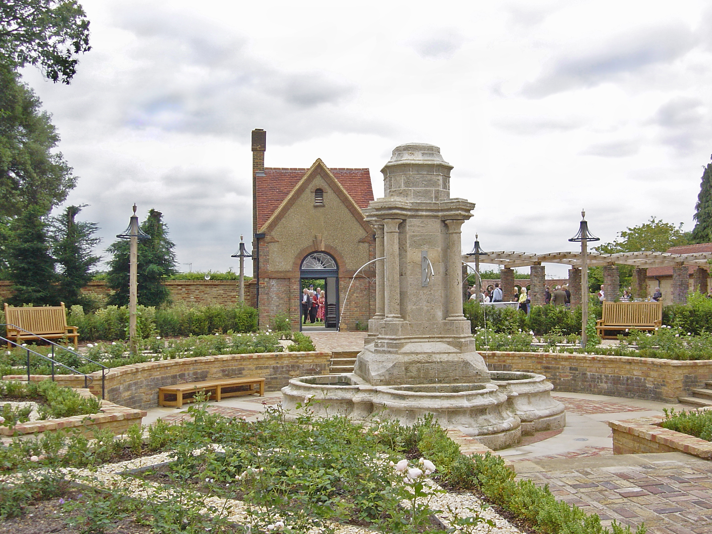
Bushey Rose Garden

Bushey Rose Garden is a rose garden in Bushey, Hertfordshire, England. == History == It was created in 1913 by the noted garden designer Thomas Hayton...

Bushey

Bushey is a town in the Hertsmere borough of Hertfordshire in the East of England. It had a population of 25,328 in the 2011 census, rising to 28,416 in...

Oxhey

Oxhey is a suburb of Watford, under the jurisdiction of the Watford Borough Council of the county of Hertfordshire, England. It is located at grid reference...

Bushey Studios

Bushey Studios was a British film studio located in Melbourne Road, Bushey, Hertfordshire which operated between 1913 and 1985. The studios were built...
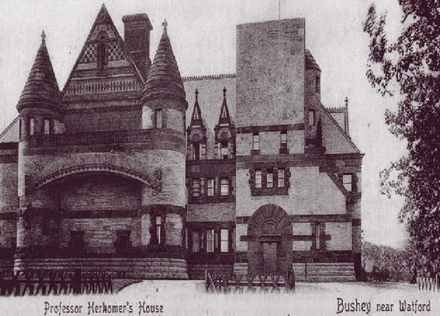
Lululaund

Lululaund was the Romanesque Revival-style house and studio of the Bavarian-born British artist Hubert von Herkomer, in Melbourne Road, Bushey, Hertfordshire...

Nearby Amenities

Located within 500m of 51.644875,-0.36758916
Bushey
Place: suburb
Wikidata: Q10996
Wikipedia: en:Bushey
Lat/Long: 51.6441535/-0.3622403
Mini Roundabout
Lat/Long: 51.6483082/-0.3661252
Traffic Calming: table
Lat/Long: 51.6472189/-0.3644619
Traffic Calming: island
Lat/Long: 51.648625/-0.3662365
Bushey Museum
Tourism: museum
Website: https://busheymuseum.org
Wikidata: Q5001498
Lat/Long: 51.6455641/-0.3651725
Fire Station
Lat/Long: 51.6454513/-0.3652759
Bus Stop
The Red Lion Public House
Bus: yes
Naptan AtcoCode: 210021005000
Naptan Bearing: W
Naptan CommonName: Red Lion PH
Naptan Crossing: Kemp Place
Naptan Indicator: opp
Naptan Landmark: Kemp Place
Naptan NaptanCode: hrtgmwmj
Naptan PlusbusZoneRef: WATFDJ
Naptan ShortCommonName: NA
Naptan Street: High Street
Naptan Verified: no
Public Transport: platform
Shelter: yes
Source: naptan_import
Lat/Long: 51.6448938/-0.3666137
Bus Stop
Grange Academy
Bus: yes
Naptan AtcoCode: 210021006010
Naptan Bearing: E
Naptan CommonName: Hall School
Naptan Crossing: Falconer Road
Naptan Indicator: o/s
Naptan Landmark: Falconer Road
Naptan NaptanCode: hrtgmtpd
Naptan PlusbusZoneRef: WATFDJ
Naptan ShortCommonName: NA
Naptan Street: London Road
Naptan Verified: no
Public Transport: platform
Ref: 50252
Shelter: yes
Source: naptan_import
Lat/Long: 51.6454965/-0.3694358
Bus Stop
The Red Lion Public House
Bus: yes
Naptan AtcoCode: 210021006020
Naptan Bearing: E
Naptan CommonName: Red Lion PH
Naptan Crossing: Falconer Road
Naptan Indicator: nr
Naptan Landmark: Falconer Road
Naptan NaptanCode: hrtgmtpg
Naptan PlusbusZoneRef: WATFDJ
Naptan ShortCommonName: NA
Naptan Street: High Street
Naptan Verified: no
Public Transport: platform
Shelter: yes
Source: naptan_import
Lat/Long: 51.6451494/-0.3674665
Bus Stop
Bournehall Road
Bus: yes
Naptan AtcoCode: 210021006030
Naptan Bearing: E
Naptan CommonName: Bournehall Road
Naptan Crossing: Koh-I-Noor Avenue
Naptan Indicator: nr
Naptan Landmark: Koh-I-Noor Avenue
Naptan NaptanCode: hrtgmtpj
Naptan PlusbusZoneRef: WATFDJ
Naptan ShortCommonName: NA
Naptan Street: High Street
Naptan Verified: no
Public Transport: platform
Shelter: no
Source: naptan_import
Lat/Long: 51.6444686/-0.3633475
Bus Stop
Bournehall Road
Naptan AtcoCode: 210021007930
Naptan Bearing: W
Naptan CommonName: Bournehall Road
Naptan Indicator: opp
Naptan Landmark: Unknown
Naptan NaptanCode: hrtgmjmt
Naptan PlusbusZoneRef: WATFDJ
Naptan ShortCommonName: NA
Naptan Street: High Street
Naptan Verified: no
Public Transport: platform
Source: naptan_import
Lat/Long: 51.6441976/-0.3626008
Bus Stop
Herkomer Road
Bus: yes
Naptan AtcoCode: 210021008280
Naptan Bearing: S
Naptan CommonName: Herkomer Road
Naptan Indicator: S-bound
Naptan Landmark: Unknown
Naptan NaptanCode: hrtgmgta
Naptan PlusbusZoneRef: WATFDJ
Naptan ShortCommonName: NA
Naptan Street: Bournehall Avenue
Naptan Verified: no
Public Transport: platform
Shelter: yes
Source: naptan_import
Lat/Long: 51.6476017/-0.3640586
Bus Stop
Herkomer Road
Bus: yes
Naptan AtcoCode: 210021008440
Naptan Bearing: N
Naptan CommonName: Herkomer Road
Naptan Indicator: N-bound
Naptan Landmark: Unknown
Naptan NaptanCode: hrtgmgjp
Naptan PlusbusZoneRef: WATFDJ
Naptan ShortCommonName: NA
Naptan Street: Bournehall Avenue
Naptan Verified: no
Public Transport: platform
Source: naptan_import
Lat/Long: 51.6481047/-0.3638334
Bus Stop
Bushey Academy
Naptan AtcoCode: 210021085020
Naptan Bearing: E
Naptan BusStopType: CUS
Naptan CommonName: Bushey Hall School
Naptan Indicator: o/s
Naptan Landmark: Unknown
Naptan NaptanCode: hrtgmdtd
Naptan PlusbusZoneRef: WATFDJ
Naptan ShortCommonName: NA
Naptan Street: High Street
Naptan Verified: no
Public Transport: platform
Source: naptan_import
Lat/Long: 51.6460987/-0.3693917
Post Office
Bushey Post Office
Addr City: Bushey
Addr Postcode: WD23 3HD
Addr Street: High Street
Branch: Bushey
Brand: Post Office
Brand Wikidata: Q1783168
Check Date: 2020-02-20
Contact Website: https://www.postoffice.co.uk/branch-finder/0580333/bushey-high-street
Ref Pol Id: 18090
Lat/Long: 51.6447595/-0.3652744
Pharmacy
Abell Chemist
Addr City: Bushey
Addr Housename: Bushey Medical Centre
Addr Postcode: WD23 2NN
Addr Street: London Road
Dispensing: yes
Drive Through: no
Healthcare: pharmacy
Lat/Long: 51.6454468/-0.3741038
Recycling
Recycling Type: container
Lat/Long: 51.6440008/-0.3657527
Atm
Lat/Long: 51.6451738/-0.3674352
Spar
Brand: Spar
Brand Wikidata: Q610492
Brand Wikipedia: en:Spar (retailer)
Shop: convenience
Lat/Long: 51.6447124/-0.3649015
Pub
The King Stag
Addr City: Bushey
Addr Housename: The King Stagg
Addr Housenumber: 15
Addr Postcode: WD23 3EH
Addr Street: Bournehall Road
Opening Hours: Mo-Th 12:00-23:00; Fr,Sa 12:00-24:00; Su 12:00-22:30
Opening Hours Kitchen: Mo-Fr 12:00-14:30,18:00-21:00; Sa-Su 12:00-15:00,18:00-21:00; Dec 25-26 12:00-14:30,18:00-21:00 "subject to change"
Lat/Long: 51.6454823/-0.3630005
Bus Stop
Grange Academy
Bus: yes
Naptan AtcoCode: 210021005010
Naptan Bearing: W
Naptan CommonName: Bushey Academy
Naptan Crossing: Merry Hill Road
Naptan Indicator: opp
Naptan NaptanCode: hrtgmwmp
Naptan PlusbusZoneRef: WATFDJ
Naptan ShortCommonName: NA
Naptan Street: London Road
Naptan Verified: no
Public Transport: platform
Ref: 53541
Shelter: yes
Source: naptan_import
Lat/Long: 51.6457282/-0.3717163
Pub
The Swan
Addr City: Bushey
Addr Housenumber: 25
Addr Postcode: WD23 3EE
Addr Street: Park Road
Brewery: yes
Check Date: 2019-07-25
Contact Facebook: https://www.facebook.com/TheSwanBushey/
Opening Hours: Mo-Sa 12:00-23:00; Su 12:00-22:30
Smoking: outside
Lat/Long: 51.6454739/-0.3642928
Crossing
Crossing: marked
Crossing Markings: surface
Lat/Long: 51.6438381/-0.3627034
Crossing
Crossing: marked
Crossing Markings: surface
Lat/Long: 51.6436117/-0.3631785
Traffic Calming: cushion
Lat/Long: 51.6481338/-0.3659224
Direction: 75
Generator Method: photovoltaic
Generator Output Electricity: yes
Generator Solar Modules: 16
Generator Source: solar
Generator Type: solar_photovoltaic_panel
Location: roof
Power: generator
Lat/Long: 51.6482898/-0.3657738
Traffic Calming: cushion
Lat/Long: 51.6474093/-0.3649348
Traffic Calming: hump
Lat/Long: 51.6477979/-0.3655319
Direction: 120
Generator Method: photovoltaic
Generator Output Electricity: yes
Generator Solar Modules: 14
Generator Source: solar
Generator Type: solar_photovoltaic_panel
Location: roof
Power: generator
Lat/Long: 51.6477828/-0.3670297
Direction: 120
Generator Method: photovoltaic
Generator Output Electricity: yes
Generator Solar Modules: 16
Generator Source: solar
Generator Type: solar_photovoltaic_panel
Location: roof
Power: generator
Lat/Long: 51.6476482/-0.3672391
Direction: 120
Generator Method: photovoltaic
Generator Output Electricity: yes
Generator Solar Modules: 16
Generator Source: solar
Generator Type: solar_photovoltaic_panel
Location: roof
Power: generator
Lat/Long: 51.6474904/-0.367388
Traffic Calming: table
Lat/Long: 51.6466085/-0.3677174
Traffic Calming: table
Lat/Long: 51.6459453/-0.3682643
Crossing
Crossing: unmarked
Lat/Long: 51.6453713/-0.3687149
Grange Academy
Bus: yes
Public Transport: stop_position
Lat/Long: 51.6454493/-0.3694549
Crossing
Crossing: unmarked
Lat/Long: 51.6453484/-0.3689872
Crossing
Crossing: unmarked
Crossing Island: yes
Tactile Paving: yes
Traffic Calming: island
Lat/Long: 51.6451156/-0.3676986
Grange Academy
Bus: yes
Public Transport: stop_position
Lat/Long: 51.6457569/-0.3717042
Crossing
Crossing: marked
Lat/Long: 51.6456877/-0.3709204
Give Way
Direction: forward
Lat/Long: 51.6448885/-0.3661254
Crossing
Crossing: traffic_signals
Lat/Long: 51.6447825/-0.3657818
Traffic Calming: table
Lat/Long: 51.6461735/-0.3625461
Direction: 210
Generator Method: photovoltaic
Generator Output Electricity: yes
Generator Solar Modules: 10
Generator Source: solar
Generator Type: solar_photovoltaic_panel
Location: roof
Power: generator
Lat/Long: 51.6454772/-0.3615754
Direction: 220
Generator Method: photovoltaic
Generator Output Electricity: yes
Generator Solar Modules: 5
Generator Source: solar
Generator Type: solar_photovoltaic_panel
Location: roof
Power: generator
Lat/Long: 51.6471198/-0.3635386
Direction: 265
Generator Method: photovoltaic
Generator Output Electricity: yes
Generator Solar Modules: 8
Generator Source: solar
Generator Type: solar_photovoltaic_panel
Location: roof
Power: generator
Lat/Long: 51.644507/-0.3703404
Direction: 85
Generator Method: photovoltaic
Generator Output Electricity: yes
Generator Solar Modules: 9
Generator Source: solar
Generator Type: solar_photovoltaic_panel
Location: roof
Power: generator
Lat/Long: 51.644507/-0.3702583
Crossing
Crossing: marked
Crossing Markings: surface
Tactile Paving: yes
Lat/Long: 51.6442545/-0.3624295
Crossing
Crossing: marked
Crossing Markings: surface
Tactile Paving: yes
Lat/Long: 51.6445302/-0.3636576
Crossing
Crossing: marked
Crossing Island: no
Crossing Markings: surface
Tactile Paving: yes
Lat/Long: 51.6446484/-0.3646638
Give Way
Direction: backward
Lat/Long: 51.6453298/-0.3687429
Bench
Lat/Long: 51.6448905/-0.3677555
Bench
Lat/Long: 51.6448829/-0.367805
Bench
Lat/Long: 51.6448748/-0.3678549
Waste Basket
Lat/Long: 51.6448875/-0.3677785
Waste Basket
Lat/Long: 51.6448784/-0.3678276
Crossing
Crossing: unmarked
Lat/Long: 51.6450304/-0.3674257
Crossing
Crossing: unmarked
Lat/Long: 51.6451083/-0.3680669
Give Way
Direction: forward
Lat/Long: 51.6448418/-0.3663374
Cafe
Name En: Duran's
Lat/Long: 51.6446018/-0.3639071
Restaurant
Name En: Barracuda
Lat/Long: 51.6447756/-0.3657197
Give Way
Direction: backward
Lat/Long: 51.6472427/-0.3644285
Give Way
Direction: backward
Lat/Long: 51.646817/-0.3636212
Traffic Calming: table
Lat/Long: 51.6469055/-0.3638538
Give Way
Lat/Long: 51.6465936/-0.3633265
Give Way
Direction: backward
Lat/Long: 51.6463399/-0.3626505
Traffic Calming: table
Lat/Long: 51.6457357/-0.3619232
Direction: forward
Traffic Calming: table
Lat/Long: 51.6453417/-0.3607966
Direction: backward
Traffic Calming: table
Lat/Long: 51.645229/-0.3604661
Give Way
Direction: backward
Lat/Long: 51.6454696/-0.3605161
Give Way
Direction: forward
Lat/Long: 51.6453213/-0.3606189
Give Way
Lat/Long: 51.6454855/-0.3613288
Turning Circle
Lat/Long: 51.6441676/-0.361201
Give Way
Lat/Long: 51.6454342/-0.3655372
Turning Circle
Lat/Long: 51.6458788/-0.3673227
Give Way
Direction: backward
Lat/Long: 51.647949/-0.3656862
Give Way
Lat/Long: 51.6475318/-0.3652216
Crossing
Crossing: marked
Crossing Island: no
Crossing Markings: surface
Tactile Paving: yes
Lat/Long: 51.6448231/-0.3663454
Crossing
Crossing: marked
Crossing Markings: surface
Tactile Paving: yes
Lat/Long: 51.6439696/-0.3613753
Crossing
Crossing: marked
Crossing Markings: surface
Lat/Long: 51.6438363/-0.3625437
Crossing
Crossing: marked
Crossing Markings: surface
Lat/Long: 51.6437805/-0.3623043
Crossing
Crossing: marked
Crossing Markings: surface
Lat/Long: 51.6437276/-0.3620775
Crossing
Crossing: marked
Crossing Markings: surface
Lat/Long: 51.6436932/-0.3619296
Crossing
Crossing: marked
Crossing Markings: surface
Lat/Long: 51.6436446/-0.3618711
Parking
Access: private
Parking: underground
Lat/Long: 51.6448351/-0.36379
Crossing
Crossing: marked
Crossing Island: no
Crossing Markings: surface
Tactile Paving: yes
Lat/Long: 51.6449082/-0.3661075
Give Way
Direction: backward
Lat/Long: 51.6446254/-0.364671
Give Way
Lat/Long: 51.6445115/-0.3636688
The data included in this document is from www.openstreetmap.org. The data is made available under ODbL.

Have you been to Bushey Pond?

Leave your review of Bushey Pond below (or comments, questions and feedback).