Chrysalis Lake

Lake, Pool, Pond, Freshwater Marsh in Hertfordshire St. Albans

England

Chrysalis Lake

M1/M25 Junction It's noisy, hostile and bleak but the motorway junction occupies about half the entire grid square so is the dominating feature. Photo taken looking South down the M1 from the bridge at TL115038.
M1/M25 Junction Credit: Rob Hinkley

Chrysalis Lake is a stunning freshwater body located in Hertfordshire, England. With its serene and picturesque surroundings, it serves as a popular destination for nature enthusiasts and those seeking tranquility.

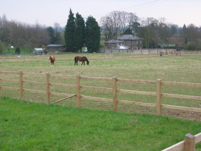
This lake, often referred to as a pool or pond due to its relatively small size, covers an area of approximately 2 acres. It is nestled within a lush green landscape, surrounded by trees and shrubs that provide a habitat for a diverse range of wildlife. The calm and clear waters of Chrysalis Lake offer a perfect reflection of its idyllic setting, creating a captivating sight for visitors.

The lake is renowned for its abundant freshwater marsh, which lies adjacent to its shores. This marshland is characterized by its wet and spongy terrain, supporting various species of plants and animals that thrive in such environments. It acts as a vital ecosystem, attracting numerous bird species and serving as a breeding ground for amphibians and insects.

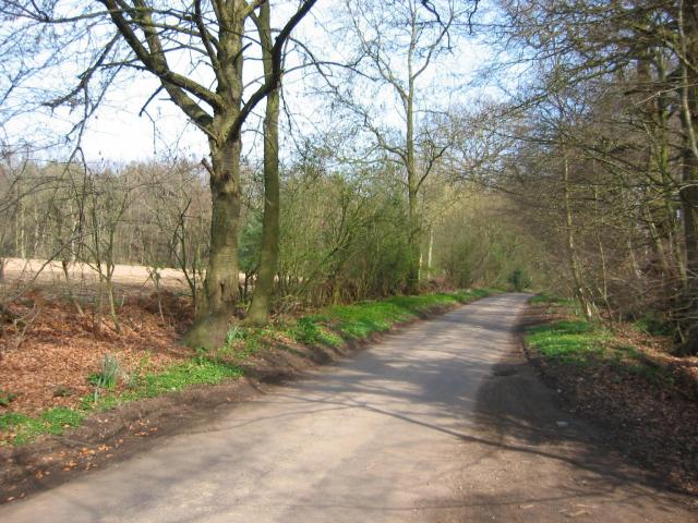
Chrysalis Lake is easily accessible, with well-maintained footpaths and boardwalks allowing visitors to explore its surroundings. These paths also provide opportunities for birdwatching and spotting other forms of wildlife that inhabit the area.

For those seeking recreational activities, fishing is permitted in Chrysalis Lake, attracting angling enthusiasts who can try their luck at catching some of the freshwater fish species that inhabit its waters. However, it is important to note that fishing is subject to local regulations and permits.

Overall, Chrysalis Lake in Hertfordshire offers a serene and natural retreat, showcasing the beauty of a freshwater ecosystem and providing a sanctuary for both wildlife and visitors alike.

If you have any feedback on the listing, please let us know in the comments section below.

Chrysalis Lake Images

Images are sourced within 2km of 51.725483/-0.36782931 or Grid Reference TL1204. Thanks to Geograph Open Source API. All images are credited.

M1/M25 Junction It's noisy, hostile and bleak but the motorway junction occupies about half the entire grid square so is the dominating feature. Photo taken looking South down the M1 from the bridge at TL115038.
M1/M25 Junction
It's noisy, hostile and bleak but the motorway junction occupies about half the entire grid square so is the dominating feature. Photo taken looking South down the M1 from the bridge at TL115038.
Pylon and copse Looking North from TL117043, we see the power lines jump over a little copse. That's pretty much the most significant landmark in the grid square.
Pylon and copse
Looking North from TL117043, we see the power lines jump over a little copse. That's pretty much the most significant landmark in the grid square.
The 'Holly Bush' at Potters Crouch The 'Holly Bush' pub at Potters Crouch: a village of about 4 houses.
And yes, Potters Crouch is its real name - I'm not making it up.
The 'Holly Bush' at Potters Crouch
The 'Holly Bush' pub at Potters Crouch: a village of about 4 houses. And yes, Potters Crouch is its real name - I'm not making it up.
Barn-like house, Potters Crouch Looking East into Potters Crouch on the road from Bedmond (at TL114052).
Barn-like house, Potters Crouch
Looking East into Potters Crouch on the road from Bedmond (at TL114052).
Daneswick farm buildings Looking SE from TL122046
Daneswick farm buildings
Looking SE from TL122046
Road from Potters Crouch to Chiswell Green Looking East from TL123052 with copse on the right, open field and then woods on the left.
Road from Potters Crouch to Chiswell Green
Looking East from TL123052 with copse on the right, open field and then woods on the left.
Gateway to suburbia On the Western edge of Chiswell Green, having just left the farmland behind, looking East from TL131045.
Gateway to suburbia
On the Western edge of Chiswell Green, having just left the farmland behind, looking East from TL131045.
M10, from bridge. Looking East from the bridge over the M10 at TL137055.
M10, from bridge.
Looking East from the bridge over the M10 at TL137055.
M25 junction 21 This four-level stack junction dominates TL1103.
M25 junction 21
This four-level stack junction dominates TL1103.
St Alban's R.C. Church at St Julians This church is almost at the southern edge of St Albans.
St Alban's R.C. Church at St Julians
This church is almost at the southern edge of St Albans.
A road in Chiswell Green The forest trees at least show that it has some attraction
A road in Chiswell Green
The forest trees at least show that it has some attraction
The edge of the town This view from Bedmond Lane shows the abrupt demarcation between housing estate and farmland.
The edge of the town
This view from Bedmond Lane shows the abrupt demarcation between housing estate and farmland.
Shelter at How Wood Station The station has no ticket machine as the fares are collected by a travelling conductor on the "flyer"
No signals are needed as there is only one train
plying to and fro.
Shelter at How Wood Station
The station has no ticket machine as the fares are collected by a travelling conductor on the "flyer" No signals are needed as there is only one train plying to and fro.
Entrance to Tenterden House off Lye Lane This is a nursing home but I wonder how the patients cope with the continuous roar of traffic from the M25
Entrance to Tenterden House off Lye Lane
This is a nursing home but I wonder how the patients cope with the continuous roar of traffic from the M25
The M25 taken from Lye Lane bridge  Smug Oak The Tenterden nursing home is just over on the right of the picture. The brown grass area was to have been a golf course but things went wrong.
The M25 taken from Lye Lane bridge Smug Oak
The Tenterden nursing home is just over on the right of the picture. The brown grass area was to have been a golf course but things went wrong.
Petrol filling station Park Street This station is visible from the North Orbital Rd
which carries heavy traffic
Petrol filling station Park Street
This station is visible from the North Orbital Rd which carries heavy traffic
Park Street Railway Station. The station is open as this is located on the Flyer
run between St Albans and Watford. So the tickets are issued by a conductor on board
Park Street Railway Station.
The station is open as this is located on the Flyer run between St Albans and Watford. So the tickets are issued by a conductor on board
Searches Farm Searches Lane Bedmont. This is located down a single track lane BUT close to the motorway
Searches Farm Searches Lane Bedmont.
This is located down a single track lane BUT close to the motorway
Show me another place!

Chrysalis Lake is located at Grid Ref: TL1204 (Lat: 51.725483, Lng: -0.36782931)

Administrative County: Hertfordshire

District: St. Albans

Police Authority: Hertfordshire

What 3 Words

///narrow.steep.surely. Near St Albans, Hertfordshire

Related Wikis

Butterfly World, Hertfordshire

The Butterfly World Project was a visitor attraction in the village of Chiswell Green, on the outskirts of St Albans in Hertfordshire, UK, dedicated to...

Royal National Rose Society Gardens

The Royal National Rose Society Gardens, also known as The Gardens of The Rose, were the gardens and headquarters of The Royal National Rose Society at...

Chiswell Green

Chiswell Green is a village, on the southern outskirts of St Albans, in the parish of St Stephen and district of the City of St Albans in Hertfordshire...

St Stephen, Hertfordshire

St Stephen is a civil parish in the St Albans City and District in Hertfordshire, England. It is located approximately 17 miles (27 km) north-northwest...

Spielplatz

Spielplatz (German for playground) is the longest-operating naturist resort in United Kingdom, and consists of 12 acres (4.9 ha) located in the village...

M10 motorway (Great Britain)

The M10 was a motorway in Hertfordshire, England, running for approximately 3 miles (4.5 km) from the M1 motorway at junction 7 near Hemel Hempstead to...

How Wood

How Wood is a residential village, south of Park Street village between the centres of Watford and St Albans in St Stephen civil parish, Hertfordshire...

Potters Crouch

Potters Crouch is a small hamlet in Hertfordshire, England, south-west of St Albans near Chiswell Green. It is in the civil parish of St Michael. ��2...

Nearby Amenities

Located within 500m of 51.725483,-0.36782931
Turning Circle
Lat/Long: 51.7290869/-0.3642482
Crossing
Lat/Long: 51.7271847/-0.3683221
Disused Amenity: toilets
Lat/Long: 51.7270176/-0.369098
Disused Amenity: cafe
Lat/Long: 51.7276305/-0.3728467
Access: no
Barrier: toll_booth
Lat/Long: 51.7270489/-0.3687091
Direction: 160
Generator Method: photovoltaic
Generator Output Electricity: yes
Generator Solar Modules: 16
Generator Source: solar
Generator Type: solar_photovoltaic_panel
Location: roof
Power: generator
Lat/Long: 51.728504/-0.3636292
Direction: 135
Generator Method: photovoltaic
Generator Output Electricity: yes
Generator Solar Modules: 12
Generator Source: solar
Generator Type: solar_photovoltaic_panel
Location: roof
Power: generator
Lat/Long: 51.7243706/-0.3609106
Man Made: utility_pole
Lat/Long: 51.7232086/-0.3740414
Man Made: utility_pole
Lat/Long: 51.7229279/-0.3723473
Man Made: utility_pole
Lat/Long: 51.7227601/-0.3713965
Man Made: utility_pole
Lat/Long: 51.7226358/-0.3706454
Man Made: utility_pole
Lat/Long: 51.7223455/-0.368929
The data included in this document is from www.openstreetmap.org. The data is made available under ODbL.

Have you been to Chrysalis Lake?

Leave your review of Chrysalis Lake below (or comments, questions and feedback).