Staines Reservoirs

Lake, Pool, Pond, Freshwater Marsh in Middlesex Spelthorne

England

Staines Reservoirs

Staines Reservoir A view of the Staines Reservoirs in Surrey looking west along the causeway with the north and south basins either side.
Staines Reservoir Credit: John P Reeves

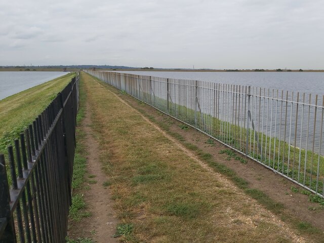
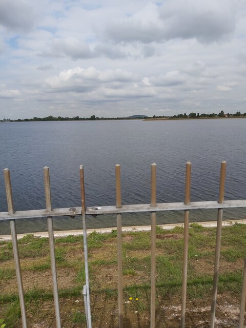
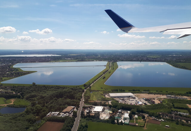
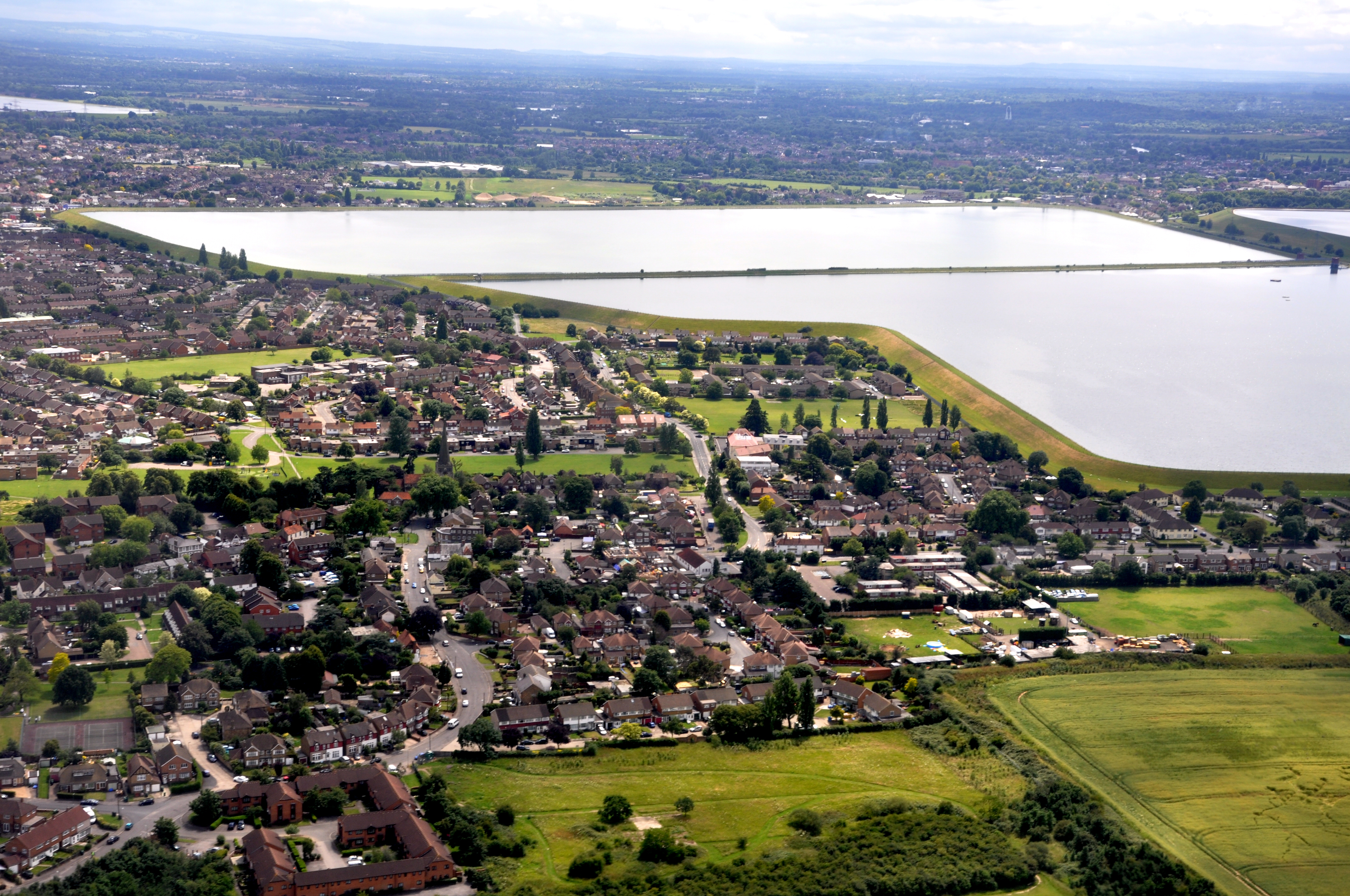
Staines Reservoirs, located in Middlesex, England, are a series of man-made freshwater bodies that serve as an important water supply for the surrounding area. Consisting of two main reservoirs, the East and West Reservoirs, they cover a combined area of approximately 400 acres.

The East Reservoir is the larger of the two, spanning an area of 254 acres, while the West Reservoir covers around 146 acres. These reservoirs were constructed in the mid-19th century to meet the increasing demand for water in London and the surrounding towns.

The reservoirs are fed by the River Thames, which flows into the East Reservoir, while the West Reservoir is supplied by a canal. The water is then treated before being distributed to homes and businesses in the region.

In addition to their function as a water supply, Staines Reservoirs also provide recreational opportunities for locals and visitors alike. The vast expanse of water attracts birdwatchers, as the reservoirs are home to a variety of bird species, including herons, kingfishers, and grebes. These tranquil waters also attract anglers, who can be seen fishing from the banks.

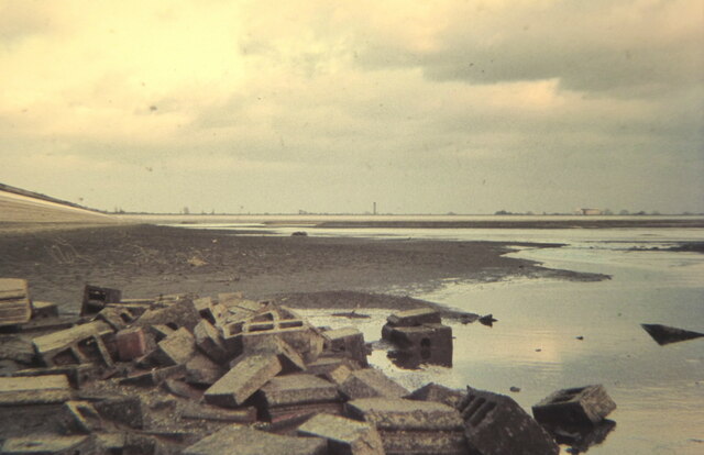
The surrounding area of Staines Reservoirs comprises grassy meadows, reed beds, and woodlands, creating a diverse habitat for wildlife. A freshwater marsh, known as the Stanwell Moor Marsh, is located adjacent to the reservoirs, further enhancing the ecological value of the site.

Overall, Staines Reservoirs in Middlesex serve as a crucial water supply source while offering a natural and recreational haven for both humans and wildlife.

If you have any feedback on the listing, please let us know in the comments section below.

Staines Reservoirs Images

Images are sourced within 2km of 51.448349/-0.48612396 or Grid Reference TQ0573. Thanks to Geograph Open Source API. All images are credited.

Staines Reservoir A view of the Staines Reservoirs in Surrey looking west along the causeway with the north and south basins either side.
Staines Reservoir
A view of the Staines Reservoirs in Surrey looking west along the causeway with the north and south basins either side.
Footpath between Roads A view of a cut through footpath between Town Lane and Diamedes Avenue in Stanwell in Surrey just east of the Staines Reservoirs.
Footpath between Roads
A view of a cut through footpath between Town Lane and Diamedes Avenue in Stanwell in Surrey just east of the Staines Reservoirs.
Staines Reservoir A view along the causeway of the Staines Reservoirs in Surrey looking west with the twin water towers visible at the end. The north and south basins are on either side of the causeway.
Staines Reservoir
A view along the causeway of the Staines Reservoirs in Surrey looking west with the twin water towers visible at the end. The north and south basins are on either side of the causeway.
Staines Reservoir A view looking across the north basin of Staines Reservoir in Surrey towards the village of Stanwell and Heathrow Airport beyond.
Staines Reservoir
A view looking across the north basin of Staines Reservoir in Surrey towards the village of Stanwell and Heathrow Airport beyond.
On the A308
On the A308
Staines and King George VI Reservoirs Close to Heathrow Airport. There is public access to the Staines Reservoir causeway, making the area popular with birdwatchers.
Staines and King George VI Reservoirs
Close to Heathrow Airport. There is public access to the Staines Reservoir causeway, making the area popular with birdwatchers.
Rubble revealed when the south reservoir was drained In the 1970s it was possible to fish in the reservoirs, the Civil Service Angling Association having the rights dating back many years. This photograph was taken around 1970.
Rubble revealed when the south reservoir was drained
In the 1970s it was possible to fish in the reservoirs, the Civil Service Angling Association having the rights dating back many years. This photograph was taken around 1970.
London Road (A30) through Staines Looking from a garage forecourt at London Road (the A30) as it passes through Staines.
London Road (A30) through Staines
Looking from a garage forecourt at London Road (the A30) as it passes through Staines.
Welcome to Bedfont In the middle of the Roman Road which is now the A30.
Surrey behind me and the London Borough of Hounslow in front.
Bedfont is twinned with places in India, Pakistan, Palestine and France.
Welcome to Bedfont
In the middle of the Roman Road which is now the A30. Surrey behind me and the London Borough of Hounslow in front. Bedfont is twinned with places in India, Pakistan, Palestine and France.
Old Deco Style Gateway Long disused but with that unmistakeable 1930s style which can still be found in a lot of places in an area which was being developed in the years before WW2.
Behind are the buildings of Thomas Knyvett College.
Old Deco Style Gateway
Long disused but with that unmistakeable 1930s style which can still be found in a lot of places in an area which was being developed in the years before WW2. Behind are the buildings of Thomas Knyvett College.
A Busy Crossroads Stanwell Road meets Staines Road (A30).
A Busy Crossroads
Stanwell Road meets Staines Road (A30).
The Scott Freeman Garden Part of a small park donated by Harry Scott Freeman (1876-1968), Olympic Gold Medallist, Lord of the Manor of Ashford, Town Clerk of Staines UDC and member of the England Ice Hockey team.
He sounds a remarkable person. More about him and Ashford on the visitor board.
<a href="https://www.geograph.org.uk/photo/7590865">TQ0672 : Visitor Board, Scott Freeman Garden</a>
The Scott Freeman Garden
Part of a small park donated by Harry Scott Freeman (1876-1968), Olympic Gold Medallist, Lord of the Manor of Ashford, Town Clerk of Staines UDC and member of the England Ice Hockey team. He sounds a remarkable person. More about him and Ashford on the visitor board. TQ0672 : Visitor Board, Scott Freeman Garden
Visitor Board, Scott Freeman Garden About the local councillor who gave this small park to the community.
Visitor Board, Scott Freeman Garden
About the local councillor who gave this small park to the community.
Old Gravel Pit There was once an extensive gravel quarrying industry in this area. An area of old pits south of here has been retained as Bedfont Lakes Country Park, but this is a bit of an outlier on the wrong side of the busy A30 and looks like it's being gradually filled in.
Old Gravel Pit
There was once an extensive gravel quarrying industry in this area. An area of old pits south of here has been retained as Bedfont Lakes Country Park, but this is a bit of an outlier on the wrong side of the busy A30 and looks like it's being gradually filled in.
The Nightingales, Stanwell Part of a residential neighbourhood between Long Lane and Short Lane. The streets are mostly named after birds or authors.
The Nightingales, Stanwell
Part of a residential neighbourhood between Long Lane and Short Lane. The streets are mostly named after birds or authors.
Longford River between the Roads The Longford and the Duke of Northumberland's Rivers flow side by side close to the west and south perimeters of Heathrow Airport.
Both man made rivers anyway, created for water supply and mill augmentation
respectively, they formerly followed separate courses but were brought together during the airport construction. 
Here they flow along a grassy strip between two main roads.
Along here, the Longford River is the county border between London and Surrey.
A fairly new border created in 1965 when Greater London and its boroughs took over most of what was once Middlesex, and Surrey inherited places like Bedfont which were outside the zone for some reason.
Longford River between the Roads
The Longford and the Duke of Northumberland's Rivers flow side by side close to the west and south perimeters of Heathrow Airport. Both man made rivers anyway, created for water supply and mill augmentation respectively, they formerly followed separate courses but were brought together during the airport construction. Here they flow along a grassy strip between two main roads. Along here, the Longford River is the county border between London and Surrey. A fairly new border created in 1965 when Greater London and its boroughs took over most of what was once Middlesex, and Surrey inherited places like Bedfont which were outside the zone for some reason.
Changes on the Corner, Ashford Townscapes are never the same for long. 
Since I was last standing in this same spot <a href="https://www.geograph.org.uk/photo/5389867">TQ0671 : Lloyds Bank on the Corner</a> the building on the corner has gained an upper storey.
And, of course, it's not Lloyds Bank any more.
Why do we still have bank holidays when there aren't any?
Changes on the Corner, Ashford
Townscapes are never the same for long. Since I was last standing in this same spot TQ0671 : Lloyds Bank on the Corner the building on the corner has gained an upper storey. And, of course, it's not Lloyds Bank any more. Why do we still have bank holidays when there aren't any?
Woodthorpe Road, Ashford An old shop terrace in between more recent developments.
Woodthorpe Road, Ashford
An old shop terrace in between more recent developments.
Show me another place!

Staines Reservoirs is located at Grid Ref: TQ0573 (Lat: 51.448349, Lng: -0.48612396)

Administrative County: Surrey

District: Spelthorne

Police Authority: Surrey

What 3 Words

///groups.fleet.lakes. Near Staines, Surrey

Nearby Locations

Staines Reservoirs

Related Wikis

Staines Reservoirs

The Staines Reservoirs are two large pumped storage reservoirs sitting to the east of the King George VI Reservoir near Heathrow airport in Surrey within...

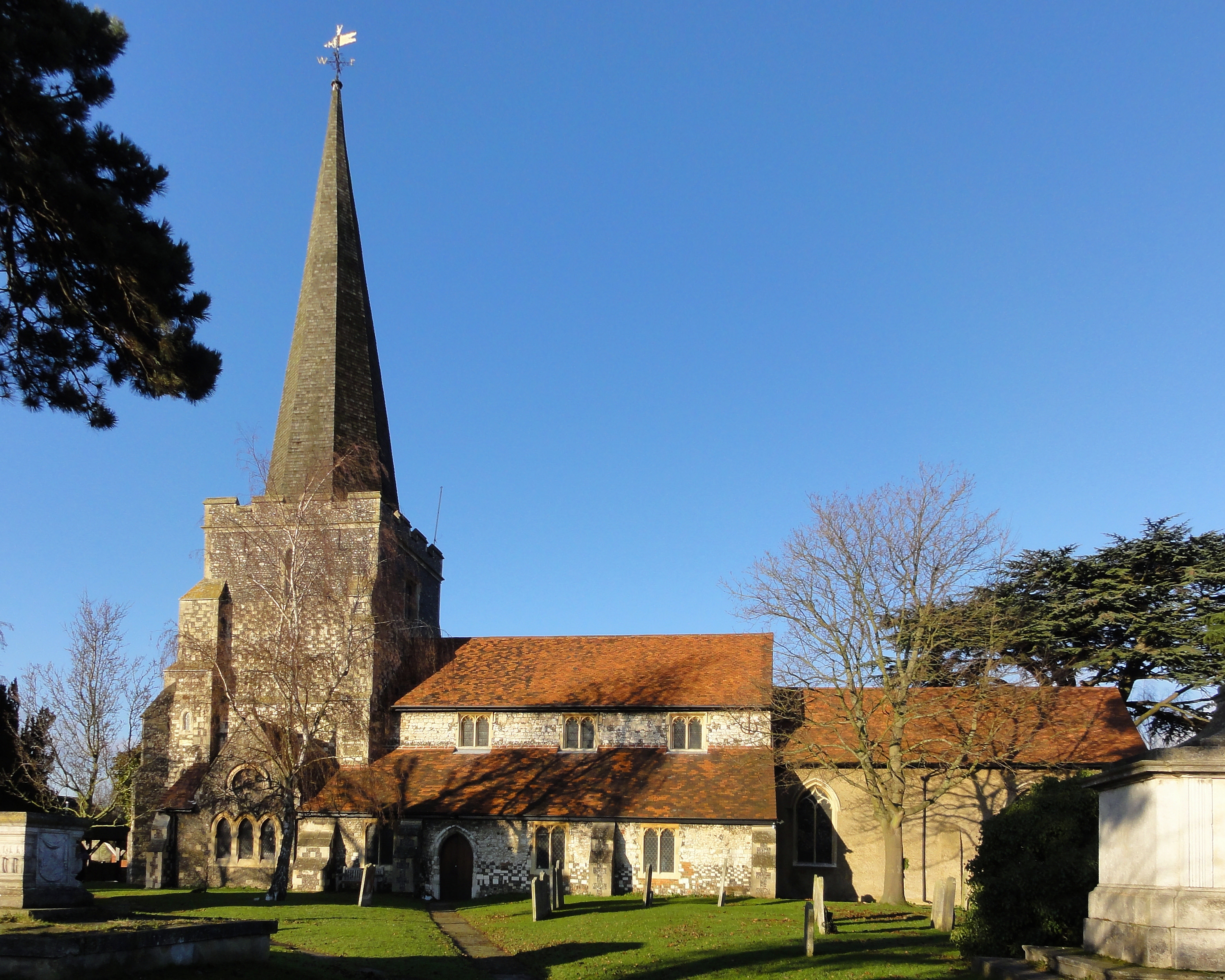
Church of St Mary, Stanwell

The Church of St Mary the Virgin, Stanwell, is a Church of England parish church in the village of Stanwell, Surrey. It dates to the 12th-century and is...

Ashford Hospital

Ashford Hospital is a general hospital in Ashford, Surrey. It is managed by the Ashford and St Peter's Hospitals NHS Foundation Trust. == History == The...

King George VI Reservoir

The King George VI Reservoir sits between Stanwell Moor and Staines upon Thames, south-west of Heathrow, England. It is between Staines Moor and a north...

Nearby Amenities

Located within 500m of 51.448349,-0.48612396
Barrier: cycle_barrier
Lat/Long: 51.4504276/-0.4798995
The data included in this document is from www.openstreetmap.org. The data is made available under ODbL.

Have you been to Staines Reservoirs?

Leave your review of Staines Reservoirs below (or comments, questions and feedback).