Shortwood Pond

Lake, Pool, Pond, Freshwater Marsh in Middlesex Spelthorne

England

Shortwood Pond

Staines Reservoir A view of the Staines Reservoirs in Surrey looking west along the causeway with the north and south basins either side.
Staines Reservoir Credit: John P Reeves

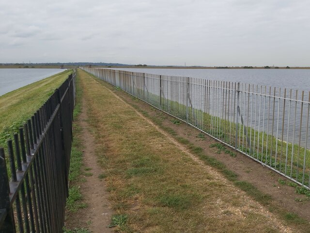
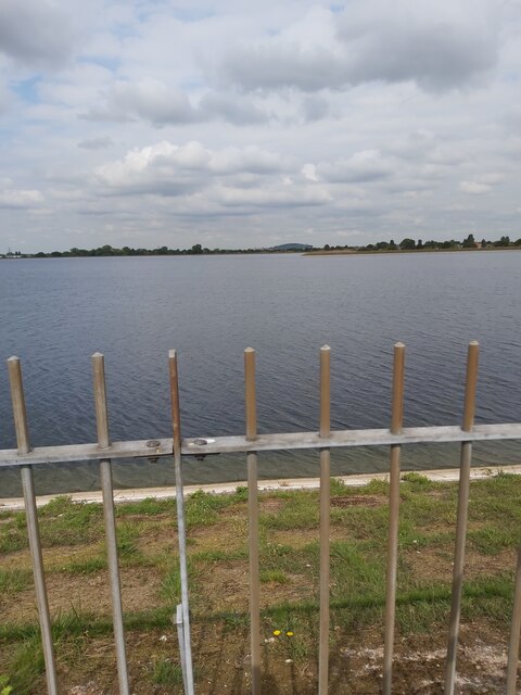
Shortwood Pond is a picturesque freshwater pond located in the county of Middlesex, England. Situated in a tranquil natural setting, it is a popular destination for nature lovers and outdoor enthusiasts alike. The pond covers an area of approximately 5 acres and is surrounded by lush greenery, creating a serene atmosphere.

The water in Shortwood Pond is crystal clear and home to a variety of aquatic life, including fish, frogs, and water birds. The pond is fed by natural springs and is well-maintained to ensure the preservation of its ecosystem. Its depth varies, with the deepest point reaching around 10 feet.

The surrounding area of the pond features a diverse range of flora, including reeds, lilies, and other water plants, which provide a habitat for numerous species of birds and insects. It is not uncommon to spot ducks, geese, and herons gracefully gliding across the water's surface.

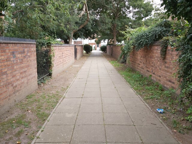
Visitors can enjoy a peaceful stroll along the banks of the pond, taking in the stunning scenery and enjoying the sounds of nature. There are also designated areas for picnics and benches for relaxation. The pond offers a tranquil escape from the hustle and bustle of city life, allowing visitors to connect with nature and experience a sense of serenity.

Shortwood Pond is easily accessible, with nearby parking facilities and walking paths. It is a haven for nature enthusiasts, providing a unique opportunity to appreciate the beauty and tranquility of a freshwater pond in the heart of Middlesex.

If you have any feedback on the listing, please let us know in the comments section below.

Shortwood Pond Images

Images are sourced within 2km of 51.436508/-0.49326304 or Grid Reference TQ0471. Thanks to Geograph Open Source API. All images are credited.

Staines Reservoir A view of the Staines Reservoirs in Surrey looking west along the causeway with the north and south basins either side.
Staines Reservoir
A view of the Staines Reservoirs in Surrey looking west along the causeway with the north and south basins either side.
Footpath between Roads A view of a cut through footpath between Town Lane and Diamedes Avenue in Stanwell in Surrey just east of the Staines Reservoirs.
Footpath between Roads
A view of a cut through footpath between Town Lane and Diamedes Avenue in Stanwell in Surrey just east of the Staines Reservoirs.
Staines Reservoir A view along the causeway of the Staines Reservoirs in Surrey looking west with the twin water towers visible at the end. The north and south basins are on either side of the causeway.
Staines Reservoir
A view along the causeway of the Staines Reservoirs in Surrey looking west with the twin water towers visible at the end. The north and south basins are on either side of the causeway.
Staines Reservoir A view looking across the north basin of Staines Reservoir in Surrey towards the village of Stanwell and Heathrow Airport beyond.
Staines Reservoir
A view looking across the north basin of Staines Reservoir in Surrey towards the village of Stanwell and Heathrow Airport beyond.
Shell fuel station
Shell fuel station
Approaching the A308
On the A308
On the A308
On the A308
On the A308
Outdoor exercise area, Lammas Recreation Ground, Staines
Houses on Greenpark, Staines
Vicarage Road, Staines
The London Stone, Staines On Church Street.
See <a href="https://www.geograph.org.uk/photo/7298114">TQ0371 : Sign for the London Stone, Staines</a> for sign.
The London Stone, Staines
On Church Street. See TQ0371 : Sign for the London Stone, Staines for sign.
Sign for the London Stone, Staines See <a href="https://www.geograph.org.uk/photo/7298113">TQ0371 : The London Stone, Staines</a> for context.
Sign for the London Stone, Staines
Church Street, Staines
The Thames Lodge, Staines
Railway bridge over the B376, Staines
St Peter's Church Staines
Houses on Laleham Road, Staines
Show me another place!

Shortwood Pond is located at Grid Ref: TQ0471 (Lat: 51.436508, Lng: -0.49326304)

Administrative County: Surrey

District: Spelthorne

Police Authority: Surrey

What 3 Words

///flesh.tribes.since. Near Staines, Surrey

Related Wikis

Dyslexia Action

Dyslexia Action (formerly the Dyslexia Institute) is an organisation based in Staines-upon-Thames, Surrey, England, founded in 1972. == History == The...

Borough of Spelthorne

Spelthorne is a local government district with borough status in Surrey, England. Its council is based in Staines-upon-Thames; other settlements in the...

HM Prison Bronzefield

HMP Bronzefield is an adult and young offender female prison located on the outskirts of Ashford in Surrey, England. Bronzefield is the only purpose-built...

Staines railway station

Staines railway station is on the Waterloo to Reading line and is the junction station for the diverging Windsor line, in southern England to the west...

Nearby Amenities

Located within 500m of 51.436508,-0.49326304
Power: tower
Lat/Long: 51.4363321/-0.4979106
Power: tower
Lat/Long: 51.4385309/-0.4963229
Power: tower
Lat/Long: 51.4385122/-0.4944401
Power: tower
Lat/Long: 51.4370986/-0.4929815
Power: tower
Lat/Long: 51.4353222/-0.4911293
Power: tower
Lat/Long: 51.4332079/-0.4889124
Power: tower
Lat/Long: 51.438592/-0.4969714
Barrier: stile
Lat/Long: 51.4368331/-0.4978543
Traffic Signals
Traffic Signals Direction: forward
Lat/Long: 51.4369578/-0.4996705
Traffic Signals
Traffic Signals Direction: forward
Lat/Long: 51.4368632/-0.4998635
Bus Stop
Shortwood Avenue
Naptan AtcoCode: 40004402019A
Naptan Bearing: NE
Naptan CommonName: Shortwood Avenue
Naptan Indicator: Just after
Naptan Landmark: Shortwood Avenue
Naptan NaptanCode: surdawgt
Naptan Street: London Road
Naptan Verified: no
Public Transport: platform
Source: naptan_import
Lat/Long: 51.4388526/-0.4914584
Bus Stop
Shortwood Avenue
Naptan AtcoCode: 40004402019B
Naptan Bearing: SW
Naptan CommonName: Shortwood Avenue
Naptan Indicator: Just Before
Naptan Landmark: Shortwood Avenue
Naptan NaptanCode: surdawgw
Naptan Street: London Road
Naptan Verified: no
Public Transport: platform
Source: naptan_import
Lat/Long: 51.4385982/-0.4915514
Bus Stop
Crooked Billet Roundabout
Bus: yes
Naptan AtcoCode: 40004402020A
Naptan Bearing: NE
Naptan CommonName: Crooked Billet
Naptan Indicator: adj
Naptan Landmark: Crooked Billet
Naptan NaptanCode: surdawjp
Naptan Street: London Road
Naptan Verified: no
Public Transport: platform
Source: naptan_import
Lat/Long: 51.4369559/-0.4987182
Bus Stop
Crooked Billet Roundabout
Bus: yes
Naptan AtcoCode: 40004402020B
Naptan Bearing: SW
Naptan CommonName: Crooked Billet
Naptan Indicator: Opp
Naptan Landmark: Crooked Billet
Naptan NaptanCode: surdawjt
Naptan Street: London Road
Naptan Verified: no
Public Transport: platform
Source: naptan_import
Lat/Long: 51.4368285/-0.498213
Crossing
Bicycle: yes
Crossing: traffic_signals
Crossing Island: no
Crossing Ref: toucan
Source: bing
Lat/Long: 51.4369497/-0.4979674
Crossing
Bicycle: yes
Crossing: traffic_signals
Crossing Island: no
Crossing Ref: toucan
Source: bing
Lat/Long: 51.4370188/-0.4981325
Traffic Signals
Traffic Signals Direction: forward
Lat/Long: 51.4372201/-0.4998897
Crossing
Bicycle: yes
Crossing: traffic_signals
Crossing Island: no
Crossing Ref: toucan
Lat/Long: 51.4368154/-0.4993982
Traffic Signals
Traffic Signals Direction: forward
Lat/Long: 51.4366224/-0.4992148
Power: tower
Lat/Long: 51.432901/-0.4907466
Power: tower
Lat/Long: 51.4347787/-0.494648
Crossing
Bicycle: yes
Crossing: traffic_signals
Crossing Island: no
Crossing Ref: toucan
Source: bing
Lat/Long: 51.4366992/-0.4993649
Barrier: kissing_gate
Lat/Long: 51.4345917/-0.4942149
Railway: switch
Lat/Long: 51.4325707/-0.4965322
Railway: switch
Lat/Long: 51.4326725/-0.4960638
Railway: buffer_stop
Lat/Long: 51.4330116/-0.4930857
Railway: buffer_stop
Lat/Long: 51.4330475/-0.4930938
Railway: buffer_stop
Lat/Long: 51.4330901/-0.493111
Traffic Signals
Lat/Long: 51.4368221/-0.4996045
Shortwood Common
Place: locality
Source Name: OS_OpenData_Streetview
Lat/Long: 51.4350025/-0.4922279
Copperbeech Osteopathic Clinic
Healthcare: alternative
Lat/Long: 51.4330072/-0.4975874
Railway: buffer_stop
Lat/Long: 51.4331185/-0.49313
Traffic Signals
Traffic Signals Direction: forward
Lat/Long: 51.4370088/-0.4981785
Traffic Signals
Traffic Signals Direction: forward
Lat/Long: 51.4369629/-0.4978977
Barrier: stile
Motor Vehicle: no
Lat/Long: 51.4374284/-0.4959585
Tactile Paving: yes
Lat/Long: 51.4365766/-0.4995998
Crossing
Bicycle: yes
Crossing: traffic_signals
Crossing Island: no
Crossing Ref: toucan
Lat/Long: 51.4365945/-0.4995057
Tactile Paving: yes
Lat/Long: 51.4366092/-0.4994285
Tactile Paving: yes
Lat/Long: 51.4366688/-0.4993506
Crossing
Bicycle: yes
Crossing: traffic_signals
Crossing Island: no
Crossing Ref: toucan
Lat/Long: 51.4365779/-0.4993003
Traffic Signals
Traffic Signals Direction: forward
Lat/Long: 51.4367074/-0.4992739
Tactile Paving: yes
Lat/Long: 51.4366092/-0.4993262
Tactile Paving: yes
Lat/Long: 51.4368794/-0.4994407
Tactile Paving: yes
Lat/Long: 51.4365374/-0.4992667
Colour: red and white
Marker: aerial
Material: plastic
Utility: gas
Lat/Long: 51.4373484/-0.500207
Street Lamp
Lat/Long: 51.4366731/-0.4987235
Colour: red and white
Marker: aerial
Material: plastic
Utility: gas
Lat/Long: 51.436679/-0.4986546
Colour: yellow
Marker: post
Material: plastic
Utility: gas
Lat/Long: 51.4366808/-0.4986585
Colour: yellow
Marker: post
Material: plastic
Utility: gas
Lat/Long: 51.437345/-0.5002049
Colour: yellow
Marker: post
Material: concrete
Utility: gas
Lat/Long: 51.4373427/-0.5002171
The data included in this document is from www.openstreetmap.org. The data is made available under ODbL.

Have you been to Shortwood Pond?

Leave your review of Shortwood Pond below (or comments, questions and feedback).