Kirby Lake

Lake, Pool, Pond, Freshwater Marsh in Leicestershire Melton

England

Kirby Lake

A6006 eastbound
A6006 eastbound Credit: Alex McGregor

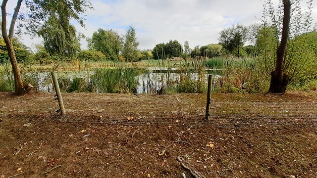
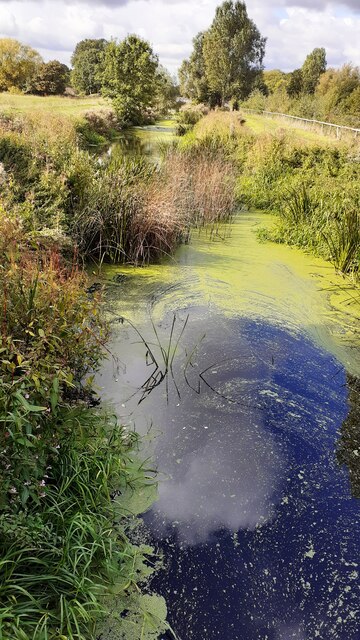
Kirby Lake is a picturesque freshwater lake situated in the county of Leicestershire, England. Covering an area of approximately 15 acres, it is nestled amidst the rural landscape, offering a serene and tranquil environment for visitors and nature enthusiasts alike.

The lake, often referred to as a pool or pond, is surrounded by lush greenery and is home to a diverse array of flora and fauna. The crystal-clear water reflects the surrounding trees, creating a stunning visual spectacle. The lake is fed by natural springs and streams, ensuring a constant flow of freshwater.

The lake serves as a vital habitat for numerous species of wildlife, including various water birds and fish. The surrounding vegetation provides excellent nesting and feeding grounds for a variety of bird species, making it a popular spot for birdwatchers. Visitors can often spot herons, ducks, and swans gracefully gliding across the calm waters.

Kirby Lake also offers recreational activities for visitors to enjoy. Anglers can be seen casting their lines into the water, hoping to catch carp, pike, and roach, among other fish species. The lake is well-stocked and offers a peaceful setting for fishing enthusiasts.

Additionally, the lake is surrounded by well-maintained pathways, providing an ideal spot for leisurely strolls or picnics. The peaceful ambiance and natural beauty of Kirby Lake make it a popular destination for families, couples, and individuals seeking a peaceful escape from the hustle and bustle of city life.

In conclusion, Kirby Lake in Leicestershire is a stunning freshwater lake that offers a haven of tranquility and natural beauty. With its diverse wildlife, recreational activities, and scenic surroundings, it is a must-visit destination for nature lovers and those looking for a peaceful retreat.

If you have any feedback on the listing, please let us know in the comments section below.

Kirby Lake Images

Images are sourced within 2km of 52.758226/-0.95515778 or Grid Reference SK7018. Thanks to Geograph Open Source API. All images are credited.

A6006 eastbound
A6006 eastbound
Loughborough Road
Loughborough Road
SW parapet of bridge taking A6006 (Loughborough Road) over stream near Grimston Gap Ordnance Survey records indicate that a benchmark levelled at 77.636m above Newlyn Datum was verified in 1962 on the parapet over the centre of the stream
SW parapet of bridge taking A6006 (Loughborough Road) over stream near Grimston Gap
Ordnance Survey records indicate that a benchmark levelled at 77.636m above Newlyn Datum was verified in 1962 on the parapet over the centre of the stream
Stile on footpath from Grimston Gap to Hoby Road west of Asfordby
Benchmark on building at Sandlands Farm Ordnance Survey cut mark benchmark levelled at 70.339m above Newlyn Datum verified 1962
Benchmark on building at Sandlands Farm
Ordnance Survey cut mark benchmark levelled at 70.339m above Newlyn Datum verified 1962
Buildings at Sandlands Farm There is an Ordnance Survey benchmark <a href="https://www.geograph.org.uk/photo/7300335">SK6818 : Benchmark on building at Sandlands Farm</a> on the road face of the nearest barn
Buildings at Sandlands Farm
There is an Ordnance Survey benchmark SK6818 : Benchmark on building at Sandlands Farm on the road face of the nearest barn
St Thomas of Canterbury Church and graveyard There is an Ordnance Survey benchmark <a href="https://www.geograph.org.uk/photo/3977389">SK6917 : Benchmark on St Thomas of Canterbury Church</a> on the buttress on the right hand corner of the tower: the mark levelled at 70.409m above Newlyn Datum was verified in 1962
St Thomas of Canterbury Church and graveyard
There is an Ordnance Survey benchmark SK6917 : Benchmark on St Thomas of Canterbury Church on the buttress on the right hand corner of the tower: the mark levelled at 70.409m above Newlyn Datum was verified in 1962
Footpath heading south through ploughed field south of A607
Badger latrine beside footpath through field west of Asfordby
Pond beside footpath at Asfordby Carp Pools
Ploughed footpath heading for A6006 at Grimston Gap
Footpath heading for Loughborough Road from Hoby Road
Benchmark on outbuilding at Red Lodge Farm on NW side of Hoby Road Ordnance Survey cut mark benchmark levelled at 69.065m above Newlyn Datum verified 1962
Benchmark on outbuilding at Red Lodge Farm on NW side of Hoby Road
Ordnance Survey cut mark benchmark levelled at 69.065m above Newlyn Datum verified 1962
Red Lodge Farm outbuilding on NW side of Hoby Road There is an Ordnance Survey benchmark <a href="https://www.geograph.org.uk/photo/7314361">SK6918 : Benchmark on outbuilding at Red Lodge Farm on NW side of Hoby Road</a> on the near corner, road face, of the building
Red Lodge Farm outbuilding on NW side of Hoby Road
There is an Ordnance Survey benchmark SK6918 : Benchmark on outbuilding at Red Lodge Farm on NW side of Hoby Road on the near corner, road face, of the building
Red Lodge and farm outbuilding at NW side of Hoby Road
River Wreake NE of Frisby on the Wreake
Footbridge over disused canal north of Frisby on the Wreake Ordnance Survey documents indicate that a rivet benchmark levelled at 64.785m above Newlyn Datum was verified in 1962 on the near end of the right hand bridge parapet
Footbridge over disused canal north of Frisby on the Wreake
Ordnance Survey documents indicate that a rivet benchmark levelled at 64.785m above Newlyn Datum was verified in 1962 on the near end of the right hand bridge parapet
Level crossing at Frisby on the Wreake for railway towards Melton Mowbray
Show me another place!

Kirby Lake is located at Grid Ref: SK7018 (Lat: 52.758226, Lng: -0.95515778)

Administrative County: Leicestershire

District: Melton

Police Authority: Leicestershire

What 3 Words

///proceeds.steepest.steadier. Near Asfordby, Leicestershire

Nearby Locations

Kirby Lake

Related Wikis

Asfordby

Asfordby is a village and civil parish in the Melton district of Leicestershire, to the west of Melton Mowbray on the A6006 road. The village is north...

All Saints' Church, Asfordby

All Saints' Church is a church in Asfordby, Leicestershire, England. It is a Grade I listed building. == History == The church is made up of a nave, tower...

Old Hall, Asfordby

The Old Hall is a Jacobean former manor house in the village of Asfordby, Leicestershire. Built of brick c. 1620, it has three gables. It is a Grade II...

Asfordby railway station

Asfordby railway station was a station serving the villages of Asfordby and Kirby Bellars in Leicestershire. The station was situated at a level crossing...

Nearby Amenities

Located within 500m of 52.758226,-0.95515778
Power: tower
Lat/Long: 52.7574672/-0.961856
Traffic Signals
Traffic Signals: signal
Traffic Signals Direction: forward
Lat/Long: 52.760496/-0.9567276
Traffic Signals
Traffic Signals: signal
Traffic Signals Direction: backward
Lat/Long: 52.7608032/-0.9573083
Generator Method: photovoltaic
Generator Output Electricity: yes
Generator Source: solar
Generator Type: solar_photovoltaic_panel
Location: roof
Power: generator
Lat/Long: 52.7620969/-0.9562254
Generator Method: photovoltaic
Generator Output Electricity: yes
Generator Source: solar
Generator Type: solar_photovoltaic_panel
Location: roof
Power: generator
Lat/Long: 52.7620628/-0.9567484
Generator Method: photovoltaic
Generator Output Electricity: yes
Generator Source: solar
Generator Type: solar_photovoltaic_panel
Location: roof
Power: generator
Lat/Long: 52.7619573/-0.957419
Generator Method: photovoltaic
Generator Output Electricity: yes
Generator Source: solar
Generator Type: solar_photovoltaic_panel
Location: roof
Power: generator
Lat/Long: 52.7619459/-0.9575262
Railway: crossing
Lat/Long: 52.7568256/-0.9539363
Railway: crossing
Lat/Long: 52.7567851/-0.9539328
Railway: crossing
Lat/Long: 52.7565178/-0.9616028
Railway: crossing
Lat/Long: 52.7564785/-0.961588
The data included in this document is from www.openstreetmap.org. The data is made available under ODbL.

Have you been to Kirby Lake?

Leave your review of Kirby Lake below (or comments, questions and feedback).