Nanpanton Reservoir

Lake, Pool, Pond, Freshwater Marsh in Leicestershire Charnwood

England

Nanpanton Reservoir

The A512 west of Loughborough This main road links the town with the M1 motorway.
The A512 west of Loughborough Credit: Peter Mackenzie

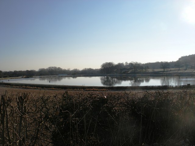
Nanpanton Reservoir is a freshwater lake located in Leicestershire, England. It is situated in the village of Nanpanton, near the town of Loughborough. The reservoir covers an area of approximately 10 acres and is surrounded by picturesque countryside, making it a popular destination for nature enthusiasts and anglers alike.

The reservoir serves as a vital water source for the local region, providing drinking water and supporting the irrigation needs of nearby farms. It was created in the 19th century by damming a small river, resulting in the formation of a deep body of water.

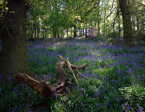
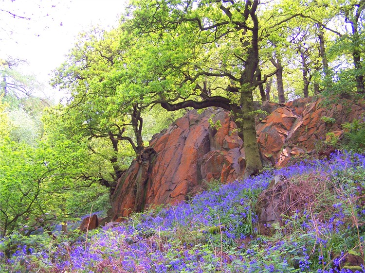
The lake boasts a diverse ecosystem, with an abundance of plant and animal life. The surrounding marshland provides a habitat for various species of birds, including ducks, swans, and herons. Fish such as pike, perch, and roach can be found in the lake, making it an attractive spot for fishing enthusiasts.

Nanpanton Reservoir offers a tranquil setting for those seeking relaxation and recreational activities. Visitors can enjoy walking along the lakeside paths, taking in the scenic views and observing the wildlife. Fishing permits are available for those wishing to cast a line and try their luck at catching a fish.

Overall, Nanpanton Reservoir is a beautiful and important freshwater body in Leicestershire. Its natural surroundings and diverse wildlife make it a popular destination for both locals and tourists, providing an opportunity to connect with nature and enjoy the serenity of the countryside.

If you have any feedback on the listing, please let us know in the comments section below.

Nanpanton Reservoir Images

Images are sourced within 2km of 52.748948/-1.2498592 or Grid Reference SK5017. Thanks to Geograph Open Source API. All images are credited.

The A512 west of Loughborough This main road links the town with the M1 motorway.
The A512 west of Loughborough
This main road links the town with the M1 motorway.
Road junction The road junction near Roe's plantation.
Road junction
The road junction near Roe's plantation.
Whittle Hill Lane This is the road entrance to Whittle Hill Farm.
Whittle Hill Lane
This is the road entrance to Whittle Hill Farm.
On Nanpantan Road, Nanpantan
Footpath towards Oaks in Charnwood
Ingleberry Road towards Shepshed Ingleberry Road is the B591. Note the car wheel disc on the road side.
Ingleberry Road towards Shepshed
Ingleberry Road is the B591. Note the car wheel disc on the road side.
M1 motorway crosses Ingleberry Road Ingleberry Road is the B591.
M1 motorway crosses Ingleberry Road
Ingleberry Road is the B591.
Ingleberry Road southwards
Grass field and Roe's Plantation
Temple of Venus, Garendon Park, Loughborough Considerable landscaping has taken place here in recent years. In the foreground of this view there was once a bridge carrying the Coalville - Loughborough railway line.
Temple of Venus, Garendon Park, Loughborough
Considerable landscaping has taken place here in recent years. In the foreground of this view there was once a bridge carrying the Coalville - Loughborough railway line.
Longcliffe Lodge Farm Although not obvious in this picture, this handsome house stands close to the M1 and is accompanied by the constant roar of traffic.
Longcliffe Lodge Farm
Although not obvious in this picture, this handsome house stands close to the M1 and is accompanied by the constant roar of traffic.
Bridleway to Lubcloud Farm This bridleway leads from the B5330 towards Lubcloud Farm.
Bridleway to Lubcloud Farm
This bridleway leads from the B5330 towards Lubcloud Farm.
Ploughed field
Ploughed field
Loncliffe Golf Club, Nanpantan Longcliffe Golf Club is set on the lower slopes of Charnwood Forest two and a half miles from the centre of Loughborough. The site is well forested with old and new Silver Birch, Oak, Pine, Beech, Gorse, and Broom.
Loncliffe Golf Club, Nanpantan
Longcliffe Golf Club is set on the lower slopes of Charnwood Forest two and a half miles from the centre of Loughborough. The site is well forested with old and new Silver Birch, Oak, Pine, Beech, Gorse, and Broom.
Footpath at Loncliffe Golf Club This mossy public footpath crosses the golf course on its way from Nanpantan to junction 23 on the M1. It is rather overgrown in places and there is easier walking alongside the trees to the right just on the edge of the fairways.
Footpath at Loncliffe Golf Club
This mossy public footpath crosses the golf course on its way from Nanpantan to junction 23 on the M1. It is rather overgrown in places and there is easier walking alongside the trees to the right just on the edge of the fairways.
Loncliffe Golf Club, Nanpantan Looking northwards from the public footpath. This shows the variety of trees on this attractive golf course, predominantly silver birch on this section.
Loncliffe Golf Club, Nanpantan
Looking northwards from the public footpath. This shows the variety of trees on this attractive golf course, predominantly silver birch on this section.
Golfers at Loncliffe Golf Club Looking across from the public footpath towards the woodland on Rhododendron Hill
Golfers at Loncliffe Golf Club
Looking across from the public footpath towards the woodland on Rhododendron Hill
Roe's Plantation Looking north-east across a seeding grass field to Roe's Plantation on top of the hill. Plenty of rubbish in this small lay-by near the cross roads.
Roe's Plantation
Looking north-east across a seeding grass field to Roe's Plantation on top of the hill. Plenty of rubbish in this small lay-by near the cross roads.
Show me another place!

Nanpanton Reservoir is located at Grid Ref: SK5017 (Lat: 52.748948, Lng: -1.2498592)

Administrative County: Leicestershire

District: Charnwood

Police Authority: Leicestershire

What 3 Words

///expecting.coaching.includes. Near Shepshed, Leicestershire

Related Wikis

Nanpantan Reservoir

Nanpantan Reservoir is a reservoir in Leicestershire, near Nanpantan. The reservoir, with a capacity of 132,000 cubic metres (29,000,000 imp gal), was...

Nanpantan

Nanpantan is a suburb of Loughborough, in the Charnwood borough of Leicestershire, England. It is located in the south-west of the town of Loughborough...

Jubilee Wood

Jubilee Wood comprises 10 hectares (25 acres) of mixed woodland with rocky outcrops. It was presented to Leicestershire County Council in 1977 to commemorate...

Outwoods, Leicestershire

The Outwoods is a 40 hectares (99 acres) ancient wood and visitor attraction overlooking Loughborough and the Soar Valley in Leicestershire, England. It...

Holywell Park Conference Centre

Holywell Park Conference Centre is modern conference facility located on Loughborough University Campus offering 300 m2 of exhibition space and accommodating...

Beacon Hill, Hangingstone and Outwoods

Beacon Hill, Hangingstone and Outwoods is a 147.5-hectare (364-acre) biological and geological Site of Special Scientific Interest (SSSI) south of Loughborough...

Loughborough Dynamo F.C.

Loughborough Dynamo Football Club is a football club based in Loughborough, Leicestershire, England. They are currently members of the Northern Premier...

Loughborough Foxes W.F.C.

Loughborough Foxes Women & Girls Football Club is a football club based in Loughborough, Leicestershire, England. They are currently members of the FA...

Nearby Amenities

Located within 500m of 52.748948,-1.2498592
Traffic Signals
Lat/Long: 52.7507672/-1.253276
Toilets
Lat/Long: 52.7477202/-1.2503895
Nanpantan
Place: village
Wikidata: Q6964179
Lat/Long: 52.7508089/-1.252156
Bus Stop
Priory
Alt Name: Loughborough - Nanpantan Road
Bench: yes
Bin: no
Bus: yes
Naptan AltCommonName: Loughborough - Nanpantan Road
Naptan AtcoCode: 260007242
Naptan Bearing: NE
Naptan CommonName: Priory
Naptan Indicator: outside
Naptan Landmark: Priory
Naptan NaptanCode: leidtwtw
Naptan Notes: Non-Hourly - County
Naptan Street: Nanpantan Road
Naptan Verified: no
Public Transport: platform
Shelter: yes
Source: naptan_import
Lat/Long: 52.7509766/-1.252776
Bus Stop
Nanpantan Road
Bench: no
Bin: no
Bus: yes
Lit: yes
Naptan AtcoCode: 260007243
Naptan Bearing: E
Naptan CommonName: Nanpantan Road
Naptan Indicator: outside
Naptan Landmark: 229 Nanpantan Road
Naptan NaptanCode: leidwada
Naptan Notes: Non-Hourly - County
Naptan Street: Nanpantan Road
Naptan Verified: no
Public Transport: platform
Shelter: no
Source: naptan_import
Tactile Paving: no
Lat/Long: 52.7519926/-1.2467907
Bus Stop
Nanpantan Road
Bench: no
Bin: no
Bus: yes
Lit: yes
Naptan AtcoCode: 260007248
Naptan Bearing: W
Naptan CommonName: Nanpantan Road
Naptan Indicator: opposite
Naptan Landmark: 229 Nanpantan Road
Naptan NaptanCode: leidwadt
Naptan Notes: Non-Hourly - County
Naptan Street: Nanpantan Road
Naptan Verified: no
Public Transport: platform
Shelter: no
Source: naptan_import
Tactile Paving: no
Lat/Long: 52.7519021/-1.2467034
Bus Stop
Priory
Alt Name: Loughborough - Nanpantan Road
Bench: no
Bin: no
Bus: yes
Naptan AltCommonName: Loughborough - Nanpantan Road
Naptan AtcoCode: 260007249
Naptan Bearing: SW
Naptan CommonName: Priory
Naptan Indicator: opposite
Naptan Landmark: Priory
Naptan NaptanCode: leidwadw
Naptan Notes: Non-Hourly - County
Naptan Street: Nanpantan Road
Naptan Verified: no
Public Transport: platform
Shelter: no
Source: naptan_import
Lat/Long: 52.7510061/-1.2523902
Parking
Jubilee Woods Layby
Lat/Long: 52.745118/-1.2471422
Post Box
Post Box Type: lamp
Lat/Long: 52.7505298/-1.2531312
1st Nanpantan Scout Group
Addr City: Loughborough
Addr Housenumber: 212
Addr Street: Nanpantan Road
Lat/Long: 52.7515639/-1.2447526
The data included in this document is from www.openstreetmap.org. The data is made available under ODbL.

Have you been to Nanpanton Reservoir?

Leave your review of Nanpanton Reservoir below (or comments, questions and feedback).