Burleigh Wood

Wood, Forest in Leicestershire Charnwood

England

Burleigh Wood

J23 overbridges, M1 In very wet weather.
J23 overbridges, M1 Credit: N Chadwick

Burleigh Wood is a beautiful forest located in Leicestershire, England. Covering an area of approximately 100 acres, it is a popular destination for nature enthusiasts and outdoor lovers. The wood is situated near the village of Burleigh, surrounded by picturesque countryside and rolling hills.

The woodland is primarily composed of deciduous trees, such as oak, beech, and ash, creating a diverse and vibrant ecosystem. The forest floor is covered in a thick carpet of moss, ferns, and wildflowers, adding to its natural charm. Burleigh Wood is a haven for wildlife, with various species of birds, mammals, and insects calling it home.

There are several well-maintained walking trails that wind through the wood, allowing visitors to explore and immerse themselves in its tranquil surroundings. These paths offer breathtaking views of the woodland and provide opportunities for birdwatching and photography.

The forest is also home to a number of historical features, including the remnants of an ancient Roman road that once connected nearby settlements. Archaeological excavations have unearthed pottery shards and other artifacts, providing insights into the area's rich history.

Burleigh Wood is a true gem of Leicestershire, offering a peaceful retreat from the hustle and bustle of everyday life. Whether it's a leisurely stroll, a picnic with family and friends, or simply enjoying the sights and sounds of nature, this enchanting woodland has something to offer everyone.

If you have any feedback on the listing, please let us know in the comments section below.

Burleigh Wood Images

Images are sourced within 2km of 52.754425/-1.2488613 or Grid Reference SK5017. Thanks to Geograph Open Source API. All images are credited.

J23 overbridges, M1 In very wet weather.
J23 overbridges, M1
In very wet weather.
The A512 west of Loughborough This main road links the town with the M1 motorway.
The A512 west of Loughborough
This main road links the town with the M1 motorway.
On Nanpantan Road, Nanpantan
Grass field and Roe's Plantation
Temple of Venus, Garendon Park, Loughborough Considerable landscaping has taken place here in recent years. In the foreground of this view there was once a bridge carrying the Coalville - Loughborough railway line.
Temple of Venus, Garendon Park, Loughborough
Considerable landscaping has taken place here in recent years. In the foreground of this view there was once a bridge carrying the Coalville - Loughborough railway line.
Ploughed field
Ploughed field
Loncliffe Golf Club, Nanpantan Longcliffe Golf Club is set on the lower slopes of Charnwood Forest two and a half miles from the centre of Loughborough. The site is well forested with old and new Silver Birch, Oak, Pine, Beech, Gorse, and Broom.
Loncliffe Golf Club, Nanpantan
Longcliffe Golf Club is set on the lower slopes of Charnwood Forest two and a half miles from the centre of Loughborough. The site is well forested with old and new Silver Birch, Oak, Pine, Beech, Gorse, and Broom.
Footpath at Loncliffe Golf Club This mossy public footpath crosses the golf course on its way from Nanpantan to junction 23 on the M1. It is rather overgrown in places and there is easier walking alongside the trees to the right just on the edge of the fairways.
Footpath at Loncliffe Golf Club
This mossy public footpath crosses the golf course on its way from Nanpantan to junction 23 on the M1. It is rather overgrown in places and there is easier walking alongside the trees to the right just on the edge of the fairways.
Loncliffe Golf Club, Nanpantan Looking northwards from the public footpath. This shows the variety of trees on this attractive golf course, predominantly silver birch on this section.
Loncliffe Golf Club, Nanpantan
Looking northwards from the public footpath. This shows the variety of trees on this attractive golf course, predominantly silver birch on this section.
Golfers at Loncliffe Golf Club Looking across from the public footpath towards the woodland on Rhododendron Hill
Golfers at Loncliffe Golf Club
Looking across from the public footpath towards the woodland on Rhododendron Hill
Junction 23 North M1 motorway
Roe's Plantation Looking north-east across a seeding grass field to Roe's Plantation on top of the hill. Plenty of rubbish in this small lay-by near the cross roads.
Roe's Plantation
Looking north-east across a seeding grass field to Roe's Plantation on top of the hill. Plenty of rubbish in this small lay-by near the cross roads.
Track alongside Roe's Plantation
Dry stone wall at Roe's Plantation
Nanpantan Road towards Loughborough
View towards Loughborough Looking northeast from Nanpantan Road.
View towards Loughborough
Looking northeast from Nanpantan Road.
Dry stone wall along Nanpantan Road In the distance is the town of Loughborough, nestling in the Soar Valley.
Dry stone wall along Nanpantan Road
In the distance is the town of Loughborough, nestling in the Soar Valley.
Nanpantan Road enters the Borough of Charnwood
Show me another place!

Burleigh Wood is located at Grid Ref: SK5017 (Lat: 52.754425, Lng: -1.2488613)

Administrative County: Leicestershire

District: Charnwood

Police Authority: Leicestershire

What 3 Words

///wiping.galaxy.inner. Near Shepshed, Leicestershire

Related Wikis

Nanpantan

Nanpantan is a suburb of Loughborough, in the Charnwood borough of Leicestershire, England. It is located in the south-west of the town of Loughborough...

Holywell Park Conference Centre

Holywell Park Conference Centre is modern conference facility located on Loughborough University Campus offering 300 m2 of exhibition space and accommodating...
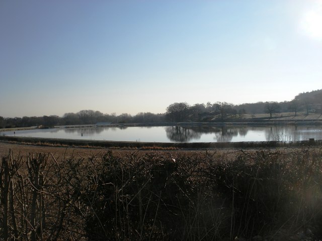
Nanpantan Reservoir

Nanpantan Reservoir is a reservoir in Leicestershire, near Nanpantan. The reservoir, with a capacity of 132,000 cubic metres (29,000,000 imp gal), was...

Loughborough University F.C.

Loughborough University Football Club (also known as Loughborough Students Football Club) is an English football club representing Loughborough University...

Cenex

Cenex, the Low Carbon and Fuel Cells Centre of Excellence, is an independent non-profit research and consultancy that helps private and public sector organisations...

Engineering Subject Centre

The Engineering Subject Centre (EngSC) was one of 24 subject centres within the Higher Education Academy from 2000 to 2011. The academy encouraged, supported...

Burleigh Court Conference Centre and Hotel

Burleigh Court Conference Centre and Hotel is a four-star hotel and conference centre located on Loughborough University campus. Opened in April 1991...

Loughborough Foxes W.F.C.

Loughborough Foxes Women & Girls Football Club is a football club based in Loughborough, Leicestershire, England. They are currently members of the FA...

Nearby Amenities

Located within 500m of 52.754425,-1.2488613
Nanpantan
Place: village
Wikidata: Q6964179
Lat/Long: 52.7508089/-1.252156
Bus Stop
Priory
Alt Name: Loughborough - Nanpantan Road
Bench: yes
Bin: no
Bus: yes
Naptan AltCommonName: Loughborough - Nanpantan Road
Naptan AtcoCode: 260007242
Naptan Bearing: NE
Naptan CommonName: Priory
Naptan Indicator: outside
Naptan Landmark: Priory
Naptan NaptanCode: leidtwtw
Naptan Notes: Non-Hourly - County
Naptan Street: Nanpantan Road
Naptan Verified: no
Public Transport: platform
Shelter: yes
Source: naptan_import
Lat/Long: 52.7509766/-1.252776
Bus Stop
Nanpantan Road
Bench: no
Bin: no
Bus: yes
Lit: yes
Naptan AtcoCode: 260007243
Naptan Bearing: E
Naptan CommonName: Nanpantan Road
Naptan Indicator: outside
Naptan Landmark: 229 Nanpantan Road
Naptan NaptanCode: leidwada
Naptan Notes: Non-Hourly - County
Naptan Street: Nanpantan Road
Naptan Verified: no
Public Transport: platform
Shelter: no
Source: naptan_import
Tactile Paving: no
Lat/Long: 52.7519926/-1.2467907
Bus Stop
Nanpantan Road
Bench: no
Bin: no
Bus: yes
Lit: yes
Naptan AtcoCode: 260007248
Naptan Bearing: W
Naptan CommonName: Nanpantan Road
Naptan Indicator: opposite
Naptan Landmark: 229 Nanpantan Road
Naptan NaptanCode: leidwadt
Naptan Notes: Non-Hourly - County
Naptan Street: Nanpantan Road
Naptan Verified: no
Public Transport: platform
Shelter: no
Source: naptan_import
Tactile Paving: no
Lat/Long: 52.7519021/-1.2467034
Bus Stop
Priory
Alt Name: Loughborough - Nanpantan Road
Bench: no
Bin: no
Bus: yes
Naptan AltCommonName: Loughborough - Nanpantan Road
Naptan AtcoCode: 260007249
Naptan Bearing: SW
Naptan CommonName: Priory
Naptan Indicator: opposite
Naptan Landmark: Priory
Naptan NaptanCode: leidwadw
Naptan Notes: Non-Hourly - County
Naptan Street: Nanpantan Road
Naptan Verified: no
Public Transport: platform
Shelter: no
Source: naptan_import
Lat/Long: 52.7510061/-1.2523902
Bus Stop
Leconfield Road
Alt Name: Loughborough - Leconfield Road
Bus: yes
Naptan AltCommonName: Loughborough - Leconfield Road
Naptan AtcoCode: 260007315
Naptan Bearing: W
Naptan CommonName: Leconfield Road
Naptan Indicator: outside
Naptan Landmark: 90 Leconfield Road
Naptan NaptanCode: leidwapa
Naptan Notes: Hourly - County
Naptan Street: Leconfield Road
Naptan Verified: no
Public Transport: platform
Source: naptan_import
Lat/Long: 52.7529564/-1.2428625
Barrier: cycle_barrier
Lat/Long: 52.7550729/-1.2446046
Barrier: kissing_gate
Lat/Long: 52.7550131/-1.2453585
1st Nanpantan Scout Group
Addr City: Loughborough
Addr Housenumber: 212
Addr Street: Nanpantan Road
Lat/Long: 52.7515639/-1.2447526
Bench
Backrest: no
Material: wood
Seats: 2
Lat/Long: 52.7566262/-1.2482317
Bench
Backrest: no
Material: wood
Seats: 2
Lat/Long: 52.7565755/-1.2484199
Burleigh Wood information board
Board Type: nature
Information: board
Operator: Loughborough University
Tourism: information
Lat/Long: 52.7550083/-1.2456201
Generator Method: photovoltaic
Generator Output Electricity: yes
Generator Source: solar
Generator Type: solar_photovoltaic_panel
Location: roof
Power: generator
Lat/Long: 52.7552551/-1.2416636
Generator Method: photovoltaic
Generator Output Electricity: yes
Generator Source: solar
Generator Type: solar_photovoltaic_panel
Location: roof
Power: generator
Lat/Long: 52.7549182/-1.2446148
Generator Method: photovoltaic
Generator Output Electricity: yes
Generator Source: solar
Generator Type: solar_photovoltaic_panel
Location: roof
Power: generator
Lat/Long: 52.7544191/-1.2418587
Generator Method: photovoltaic
Generator Output Electricity: yes
Generator Source: solar
Generator Type: solar_photovoltaic_panel
Location: roof
Power: generator
Lat/Long: 52.7552408/-1.2420767
Generator Method: photovoltaic
Generator Output Electricity: yes
Generator Source: solar
Generator Type: solar_photovoltaic_panel
Location: roof
Power: generator
Lat/Long: 52.7541329/-1.2430088
Generator Method: photovoltaic
Generator Output Electricity: yes
Generator Source: solar
Generator Type: solar_photovoltaic_panel
Location: roof
Power: generator
Lat/Long: 52.7534413/-1.2432173
Generator Method: photovoltaic
Generator Output Electricity: yes
Generator Source: solar
Generator Type: solar_photovoltaic_panel
Location: roof
Power: generator
Lat/Long: 52.7541661/-1.2459793
Generator Method: photovoltaic
Generator Output Electricity: yes
Generator Source: solar
Generator Type: solar_photovoltaic_panel
Location: roof
Power: generator
Lat/Long: 52.7538963/-1.2461657
Generator Method: photovoltaic
Generator Output Electricity: yes
Generator Source: solar
Generator Type: solar_photovoltaic_panel
Location: roof
Power: generator
Lat/Long: 52.7539689/-1.2463173
Generator Method: photovoltaic
Generator Output Electricity: yes
Generator Source: solar
Generator Type: solar_photovoltaic_panel
Location: roof
Power: generator
Lat/Long: 52.7536784/-1.2439395
Natural: wetland
Salt: no
Tidal: no
Wetland: spring
Lat/Long: 52.75654/-1.2488215
Bicycle Parking
Bicycle Parking: stands
Capacity: 10
Covered: yes
Lat/Long: 52.7581631/-1.2482471
Generator Method: photovoltaic
Generator Output Electricity: yes
Generator Source: solar
Generator Type: solar_photovoltaic_panel
Location: roof
Power: generator
Lat/Long: 52.7550249/-1.24495
Double Movement
Artist Name: Michael Gillespie
Artwork Type: sculpture
Material: bronze
Tourism: artwork
Lat/Long: 52.7581337/-1.2461186
The data included in this document is from www.openstreetmap.org. The data is made available under ODbL.

Have you been to Burleigh Wood?

Leave your review of Burleigh Wood below (or comments, questions and feedback).