Dewsbury Cut

Lake, Pool, Pond, Freshwater Marsh in Yorkshire

England

Dewsbury Cut

Footpath past Lees Hall Lees Hall <a href="https://www.geograph.org.uk/photo/362092">SE2319 : Lees Hall, Thornhill Lees, Dewsbury</a> is out of sight to the left; to the right is a steep embankment on top of which is a playing field, but this must be artificial as old maps show a marsh here.
Footpath past Lees Hall Credit: Stephen Craven

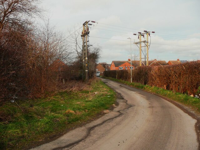
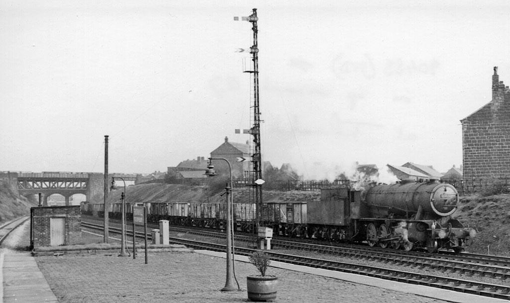
Dewsbury Cut, located in Yorkshire, is a man-made water channel that serves multiple purposes in the region. It stretches over a length of approximately 7 miles and acts as a vital link in the local waterway network. The cut was originally constructed in the 18th century to facilitate transportation of goods between the Calder and Hebble Navigation and the Aire and Calder Navigation.

Primarily, Dewsbury Cut functions as a canal, providing a navigable route for boats and barges. It is a significant component of the larger waterway system, allowing the transportation of goods and materials, particularly during the industrial era. Today, it continues to serve as a vital transport route for local businesses, albeit on a smaller scale.

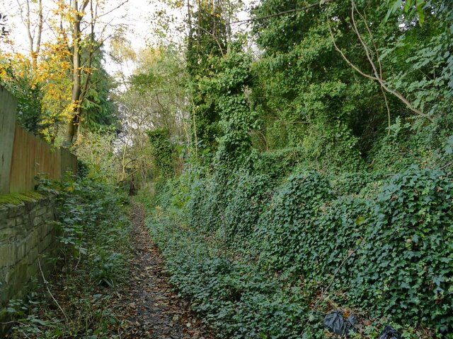
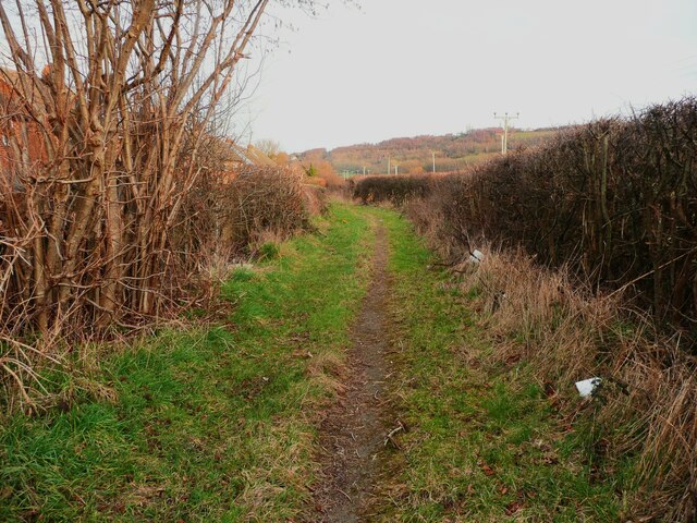
In addition to its practical purposes, Dewsbury Cut also holds ecological significance. The waterway has evolved into a thriving freshwater environment, attracting a variety of wildlife. The canal hosts a diverse range of aquatic plants, providing a habitat for fish, insects, and waterfowl. The surrounding areas, including the banks and adjacent marshlands, are populated with grasses, reeds, and other wetland vegetation, creating a dynamic ecosystem.

Recreational activities are also popular along Dewsbury Cut. Many locals and visitors enjoy peaceful walks alongside the canal, admiring the picturesque scenery and observing the wildlife. Anglers are often spotted, taking advantage of the opportunity to fish in the canal's waters.

Overall, Dewsbury Cut serves as a crucial waterway, providing transportation, supporting wildlife, and offering recreational opportunities, making it an important part of the Yorkshire landscape.

If you have any feedback on the listing, please let us know in the comments section below.

Dewsbury Cut Images

Images are sourced within 2km of 53.68092/-1.6238323 or Grid Reference SE2420. Thanks to Geograph Open Source API. All images are credited.

Footpath past Lees Hall Lees Hall <a href="https://www.geograph.org.uk/photo/362092">SE2319 : Lees Hall, Thornhill Lees, Dewsbury</a> is out of sight to the left; to the right is a steep embankment on top of which is a playing field, but this must be artificial as old maps show a marsh here.
Footpath past Lees Hall
Lees Hall SE2319 : Lees Hall, Thornhill Lees, Dewsbury is out of sight to the left; to the right is a steep embankment on top of which is a playing field, but this must be artificial as old maps show a marsh here.
Horses in a field by Lees Hall
Terrace Houses, Lees Hall Road
Moat of old hall The broad south east corner of the moat at Thornhill Old Hall
Moat of old hall
The broad south east corner of the moat at Thornhill Old Hall
Old Boundary Marker on the Calder and Hebble Canal at Thornhill Lees Canal Boundary Marker on the north side of the Calder and Hebble Canal at Thornhill Lees, Dewsbury. 

Milestone Society National ID: YW_CHDEWS07em
Old Boundary Marker on the Calder and Hebble Canal at Thornhill Lees
Canal Boundary Marker on the north side of the Calder and Hebble Canal at Thornhill Lees, Dewsbury. Milestone Society National ID: YW_CHDEWS07em
Old Boundary Marker on the Calder and Hebble Canal at Thornhill Lees Canal Boundary Marker on the north side of the Calder and Hebble Canal at Thornhill Lees, Dewsbury. 

Milestone Society National ID: YW_CHDEWS08em
Old Boundary Marker on the Calder and Hebble Canal at Thornhill Lees
Canal Boundary Marker on the north side of the Calder and Hebble Canal at Thornhill Lees, Dewsbury. Milestone Society National ID: YW_CHDEWS08em
Thornhill Double Lock, Dewsbury
Dewsbury Bridleway 94 passing a school, Thornhill Lees
Lees Hall, Thornhill Lees Built c.1412 and listed Grade 1. Previous photos:  in 1999, <a href="https://www.geograph.org.uk/photo/55430">SE2319 : Lees Hall, Thornhill</a> taken during a Heritage Open Day visit.  In 2912 <a href="https://www.geograph.org.uk/photo/2917688">SE2319 : Lees Hall</a>.  Little has changed.
Lees Hall, Thornhill Lees
Built c.1412 and listed Grade 1. Previous photos: in 1999, SE2319 : Lees Hall, Thornhill taken during a Heritage Open Day visit. In 2912 SE2319 : Lees Hall. Little has changed.
Electricity cables across Ouzelwell Lane, Thornhill Lees This is where an underground cable changes to being overhead.
Electricity cables across Ouzelwell Lane, Thornhill Lees
This is where an underground cable changes to being overhead.
Footpath around the edge of the Ouzewell Lane housing estate This path goes to King Edward Street. It seems to have been missed when the rights-of-way were established.
Footpath around the edge of the Ouzewell Lane housing estate
This path goes to King Edward Street. It seems to have been missed when the rights-of-way were established.
Mysterious chamber, Ravensthorpe Road, Thornhill Lees Possibly a capped mine shaft or access to a watercourse, old maps do not help.
Mysterious chamber, Ravensthorpe Road, Thornhill Lees
Possibly a capped mine shaft or access to a watercourse, old maps do not help.
Canal near Forge Lane Bridge Looking along the Calder and Hebble Navigation to the south of Forge Lane.
Canal near Forge Lane Bridge
Looking along the Calder and Hebble Navigation to the south of Forge Lane.
Towpath beside the Calder and Hebble Navigation Looking along the canal to the south of Forge Lane.
Towpath beside the Calder and Hebble Navigation
Looking along the canal to the south of Forge Lane.
Canal near Providence Court The Calder and Hebble Navigation as it passes through Thornhill Lees.
Canal near Providence Court
The Calder and Hebble Navigation as it passes through Thornhill Lees.
Swans and fly tipping The underneath of Brewery Lane Bridge on the Calder and Hebble Navigation.
Swans and fly tipping
The underneath of Brewery Lane Bridge on the Calder and Hebble Navigation.
Canal near Brewery Lane Looking along the Calder and Hebble Navigation from next to Brewery Lane Bridge.
Canal near Brewery Lane
Looking along the Calder and Hebble Navigation from next to Brewery Lane Bridge.
Canal east of Brewery Lane Looking along the Calder and Hebble Navigation towards Brewery Lane Bridge in the distance.
Canal east of Brewery Lane
Looking along the Calder and Hebble Navigation towards Brewery Lane Bridge in the distance.
Show me another place!

Dewsbury Cut is located at Grid Ref: SE2420 (Lat: 53.68092, Lng: -1.6238323)

Division: West Riding

Unitary Authority: Kirklees

Police Authority: West Yorkshire

What 3 Words

///land.swim.marked. Near Dewsbury, West Yorkshire

Related Wikis

Markazi Masjid, Dewsbury

The Markazi Masjid ("Central Mosque"), also known as the Dewsbury Markaz or Dar ul Ulum ("House of Knowledge"), is a mosque in the Savile Town area of...

Earlsheaton railway station

Earlsheaton was a railway station serving Earlsheaton in West Yorkshire. The station was on the Bradford, Wakefield and Leeds Railway. The station was...

Dewsbury and Savile Ground

The Dewsbury and Savile Ground was a cricket ground located in Savile Town, Dewsbury, England. It hosted 53 first class matches between 1867 and 1933....

Thornhill railway station

Thornhill (for Dewsbury) Railway station, as it was latterly known since the closure (1930) of its sister Market Place Passenger Station in the town centre...

Nearby Amenities

Located within 500m of 53.68092,-1.6238323
Savile Town
Is In: Dewsbury, West Yorkshire, England, UK
Place: suburb
Wikidata: Q7428228
Wikipedia: en:Savile Town
Lat/Long: 53.681665/-1.6281267
Railway: buffer_stop
Lat/Long: 53.6805585/-1.6250149
Pub
The Leggers Inn
Real Ale: yes
Lat/Long: 53.683637/-1.6236231
Railway: switch
Lat/Long: 53.6792025/-1.6246088
Bus Stop
Headfield Road Bretton Street
Local Ref: 45015277
Naptan AtcoCode: 450015277
Naptan Bearing: NW
Naptan CommonName: Headfield Road Bretton Street
Naptan Crossing: Adj Bretton Street
Naptan Indicator: Stop 45015277
Naptan Landmark: Adj Pentland Infant School
Naptan PlusbusZoneRef: LEEDS
Naptan ShortCommonName: Savile Town
Naptan Street: Headfield Road
Naptan Verified: no
Source: naptan_import
Lat/Long: 53.6784794/-1.6284378
Bus Stop
Headfield Road Pentland Road
Local Ref: 45015278
Naptan AtcoCode: 450015278
Naptan Bearing: NW
Naptan CommonName: Headfield Road Pentland Road
Naptan Crossing: Pentland Road
Naptan Indicator: Stop 45015278
Naptan PlusbusZoneRef: LEEDS
Naptan ShortCommonName: Pentland Road
Naptan Street: Headfield Road
Naptan Verified: no
Source: naptan_import
Lat/Long: 53.6807515/-1.6307191
Bus Stop
Headfield Road Pentland Road
Local Ref: 45015279
Naptan AtcoCode: 450015279
Naptan Bearing: SE
Naptan CommonName: Headfield Road Pentland Road
Naptan Crossing: Pentland Road
Naptan Indicator: Stop 45015279
Naptan PlusbusZoneRef: LEEDS
Naptan ShortCommonName: Pentland Road
Naptan Street: Headfield Road
Naptan Verified: no
Source: naptan_import
Lat/Long: 53.6810575/-1.6308225
Bus Stop
Warren Street Thornhill Street
Local Ref: 45026205
Naptan AtcoCode: 450026205
Naptan Bearing: NE
Naptan CommonName: Warren Street Thornhill Street
Naptan Crossing: Thornhill Street
Naptan Indicator: Stop 45026205
Naptan Landmark: Savile Town C of E Infant School
Naptan Notes: Stop for Education Route Building - is now at stop for School services only
Naptan PlusbusZoneRef: LEEDS
Naptan ShortCommonName: Thornhill Street
Naptan Street: Warren Street
Naptan Verified: no
Source: naptan_import
Lat/Long: 53.6842422/-1.6288262
Bus Stop
Warren Street
Bus: yes
Local Ref: 45026206
Naptan AtcoCode: 450026206
Naptan Bearing: W
Naptan BusStopType: CUS
Naptan CommonName: Warren Street
Naptan Crossing: Scarborough Street
Naptan Indicator: Stop 45026206
Naptan Notes: Stop for Education Route Building
Naptan PlusbusZoneRef: LEEDS
Naptan ShortCommonName: Wharf Street
Naptan Street: Warren Street
Naptan Verified: no
Public Transport: platform
Source: naptan_import
Lat/Long: 53.6843767/-1.625827
Bretton Street
Local Ref: 45026207
Naptan AtcoCode: 450026207
Naptan Bearing: SW
Naptan BusStopType: CUS
Naptan CommonName: Bretton Street
Naptan Crossing: Headfield Road
Naptan Indicator: Stop 45026207
Naptan Notes: New Dummy Stop for Education Route Building
Naptan PlusbusZoneRef: LEEDS
Naptan ShortCommonName: Headfield Road
Naptan Street: Bretton Street
Naptan Verified: no
Source: naptan_import
Lat/Long: 53.6767713/-1.6254554
Bretton Street
Local Ref: 45026210
Naptan AtcoCode: 450026210
Naptan Bearing: NE
Naptan BusStopType: CUS
Naptan CommonName: Bretton Street
Naptan Crossing: Bretfield Court
Naptan Indicator: Stop 45026210
Naptan PlusbusZoneRef: LEEDS
Naptan ShortCommonName: Bretfield Court
Naptan Street: Bretton Street
Naptan Verified: no
Source: naptan_import
Lat/Long: 53.6768439/-1.6256667
Headfield Road
Local Ref: 45050277
Naptan AtcoCode: 450050277
Naptan Bearing: SE
Naptan BusStopType: CUS
Naptan CommonName: Headfield Road
Naptan Indicator: Stop 45050277
Naptan PlusbusZoneRef: LEEDS
Naptan ShortCommonName: Headfield Road
Naptan Street: Headfield Road
Naptan Verified: no
Source: naptan_import
Lat/Long: 53.6785239/-1.6282861
Bus Stop
Warren Street Thornhill Street
Bus: yes
Local Ref: 45050279
Naptan AtcoCode: 450050279
Naptan Bearing: SW
Naptan BusStopType: CUS
Naptan CommonName: Warren Street Thornhill Street
Naptan Indicator: Stop 45050279
Naptan PlusbusZoneRef: LEEDS
Naptan ShortCommonName: Thornhill Street
Naptan Street: Warren Street
Naptan Verified: no
Public Transport: platform
Source: naptan_import
Lat/Long: 53.6842227/-1.6283267
Bus Stop
Warren Street Wharf Street
Bus: yes
Local Ref: 45050280
Naptan AtcoCode: 450050280
Naptan Bearing: E
Naptan BusStopType: CUS
Naptan CommonName: Warren Street Wharf Street
Naptan Indicator: Stop 45050280
Naptan PlusbusZoneRef: LEEDS
Naptan ShortCommonName: Wharfe Street
Naptan Street: Warren Street
Naptan Verified: no
Public Transport: platform
Source: naptan_import
Lat/Long: 53.6844845/-1.6258261
Post Box
Operator: Royal Mail
Post Box Type: wall
Ref: WF12 37
Royal Cypher: GR
Lat/Long: 53.6850518/-1.6233393
Post Office
Savile Town Post Office
Addr City: Dewsbury
Addr Postcode: WF12 9LY
Addr Suburb: Saville Town
Branch: Savile Town
Brand: Post Office
Brand Wikidata: Q1783168
Check Date: 2020-02-20
Contact Website: https://www.postoffice.co.uk/branch-finder/5253233/savile-town
Ref Pol Id: 15655
Lat/Long: 53.6840072/-1.6288664
Cafe
Old Stables Coffee House
Lat/Long: 53.6836483/-1.6238185
Post Box
Operator: Royal Mail
Post Box Type: pillar
Ref: WF12 35
Lat/Long: 53.6840239/-1.62899
Post Box
Operator: Royal Mail
Post Box Type: lamp
Ref: WF12 45
Lat/Long: 53.6812527/-1.6288163
Generator Method: photovoltaic
Generator Output Electricity: yes
Generator Source: solar
Generator Type: solar_photovoltaic_panel
Location: roof
Power: generator
Lat/Long: 53.6826453/-1.6297781
Generator Method: photovoltaic
Generator Output Electricity: yes
Generator Source: solar
Generator Type: solar_photovoltaic_panel
Location: roof
Power: generator
Lat/Long: 53.6827327/-1.626149
Generator Method: photovoltaic
Generator Output Electricity: yes
Generator Source: solar
Generator Type: solar_photovoltaic_panel
Location: roof
Power: generator
Lat/Long: 53.6818193/-1.6308823
Generator Method: photovoltaic
Generator Output Electricity: yes
Generator Source: solar
Generator Type: solar_photovoltaic_panel
Location: roof
Power: generator
Lat/Long: 53.6823626/-1.6302493
Railway: level_crossing
Lat/Long: 53.6775109/-1.6235708
Railway: switch
Lat/Long: 53.6777891/-1.6237033
Railway: level_crossing
Lat/Long: 53.6775812/-1.6236584
Railway: switch
Lat/Long: 53.6780656/-1.6238642
Headfield Junction
Railway: junction
Lat/Long: 53.6777383/-1.6236426
The data included in this document is from www.openstreetmap.org. The data is made available under ODbL.

Have you been to Dewsbury Cut?

Leave your review of Dewsbury Cut below (or comments, questions and feedback).