Blagdon Lake

Lake, Pool, Pond, Freshwater Marsh in Northumberland

England

Blagdon Lake

Bus Stop on the A1 near Shotton Interchange A brick-built shelter at the side of the northbound carriageway of the A1.
Bus Stop on the A1 near Shotton Interchange Credit: David Dixon

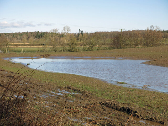
Blagdon Lake, located in Northumberland, is a picturesque freshwater lake known for its natural beauty and diverse ecosystem. Spanning an area of approximately 40 hectares, it is classified as a lake but also exhibits characteristics of a pool, pond, and freshwater marsh.

Surrounded by lush greenery and rolling hills, Blagdon Lake is a haven for various plant and animal species. The lake itself is relatively shallow, with an average depth of around 2 meters, and is fed by several small streams and springs. Its water is clear and inviting, attracting numerous waterfowl and aquatic life.

The lake is home to a wide range of flora, including water lilies, reeds, and other aquatic plants. These provide shelter and food for a diverse array of wildlife, making Blagdon Lake a popular spot for birdwatching. Visitors can often spot species such as herons, swans, ducks, and moorhens, among others.

The surrounding freshwater marsh adds to the richness of the ecosystem, providing additional habitats for amphibians, insects, and small mammals. The marsh is characterized by its wet and marshy terrain, with patches of open water and dense vegetation.

Blagdon Lake also offers recreational activities such as fishing and boating, with fishing enthusiasts being able to catch species such as pike, perch, roach, and tench. The tranquil atmosphere and scenic surroundings make this lake a popular destination for nature lovers and those seeking a peaceful retreat.

Overall, Blagdon Lake in Northumberland is a captivating freshwater ecosystem that boasts a wide range of plant and animal life, offering visitors a chance to immerse themselves in nature's beauty and tranquility.

If you have any feedback on the listing, please let us know in the comments section below.

Blagdon Lake Images

Images are sourced within 2km of 55.09438/-1.6838315 or Grid Reference NZ2077. Thanks to Geograph Open Source API. All images are credited.

Bus Stop on the A1 near Shotton Interchange A brick-built shelter at the side of the northbound carriageway of the A1.
Bus Stop on the A1 near Shotton Interchange
A brick-built shelter at the side of the northbound carriageway of the A1.
Ridley Arms, Stannington
Tree and arable field east of Milkhope Plantation
Arable field east of Milkhope Plantation This field is part of the site of the former Brenkley Lane Surface Mine - see the Google satellite image (unknown date) <span class="nowrap"><a title="https://media.geograph.org.uk/view.php?id=4337" rel="nofollow ugc noopener" href="https://media.geograph.org.uk/view.php?id=4337">Link</a><img style="margin-left:2px;" alt="External link" title="External link - shift click to open in new window" src="https://s1.geograph.org.uk/img/external.png" width="10" height="10"/></span> .
Arable field east of Milkhope Plantation
This field is part of the site of the former Brenkley Lane Surface Mine - see the Google satellite image (unknown date) LinkExternal link .
Arable field east of Milkhope Plantation (2) This field is part of the site of the former Brenkley Lane Surface Mine - see the Google satellite image (unknown date) <span class="nowrap"><a title="https://media.geograph.org.uk/view.php?id=4337" rel="nofollow ugc noopener" href="https://media.geograph.org.uk/view.php?id=4337">Link</a><img style="margin-left:2px;" alt="External link" title="External link - shift click to open in new window" src="https://s1.geograph.org.uk/img/external.png" width="10" height="10"/></span> .
Arable field east of Milkhope Plantation (2)
This field is part of the site of the former Brenkley Lane Surface Mine - see the Google satellite image (unknown date) LinkExternal link .
Field north of Milkhope Plantation
Footpath by a plantation
Footpath by a plantation (2)
Small lake in woodland
Small lake in woodland (2)
Damp farmland southwest of Bog House Farm The map and satellite image <span class="nowrap"><a title="https://wtp2.appspot.com/wheresthepath.htm?lat=55.084479&lon=-1.679355&lz=16&rz=19&lt=OS&rt=satellite&lov=None&rov=None&lgrat=None&rgrat=None" rel="nofollow ugc noopener" href="https://wtp2.appspot.com/wheresthepath.htm?lat=55.084479&lon=-1.679355&lz=16&rz=19&lt=OS&rt=satellite&lov=None&rov=None&lgrat=None&rgrat=None">Link</a><img style="margin-left:2px;" alt="External link" title="External link - shift click to open in new window" src="https://s1.geograph.org.uk/img/external.png" width="10" height="10"/></span> show two artificial ponds in this area, so the expanse of water may be related to those - or may be just waterlogged ground following several days of heavy rain.
Damp farmland southwest of Bog House Farm
The map and satellite image LinkExternal link show two artificial ponds in this area, so the expanse of water may be related to those - or may be just waterlogged ground following several days of heavy rain.
Field and Twist Plantation
Pond and Twist Plantation
Farmland west of Twist Plantation
Farmland west of Twist Plantation (2)
Farmland between Ewe Hill and Twist Plantation
Farmland south of Twist Plantation
Track in Twist Plantation
Show me another place!

Blagdon Lake is located at Grid Ref: NZ2077 (Lat: 55.09438, Lng: -1.6838315)

Unitary Authority: Northumberland

Police Authority: Northumbria

What 3 Words

///contrived.hometown.ripe. Near Stannington, Northumberland

Related Wikis

Blagdon Hall

Blagdon Hall (grid reference NZ21557705) is a privately owned English country house near Cramlington in Northumberland. It is a Grade I listed building...

Stannington, Northumberland

Stannington is a village and civil parish in Northumberland, England. The population of the civil parish was 1,219 at the 2001 Census, increasing to 1...

Shotton Surface Mine

Shotton Surface Mine was an open cast coal mine located on the estate of Blagdon Hall, Northumberland, UK, operated by Banks Group. The mine was granted...

Brenkley

Brenkley is a hamlet and former civil parish about 6 miles from Newcastle upon Tyne, now in the parish of Dinnington, in the Newcastle upon Tyne district...

Plessey railway station

Plessey railway station served the hamlet of Plessey, Northumberland, England from 1859 to 1962 on the East Coast Main Line. == History == The station...

Berwick Hill

Berwick Hill is a village and former civil parish, now in the parish of Ponteland, in the county of Northumberland, England. It is situated to the north...
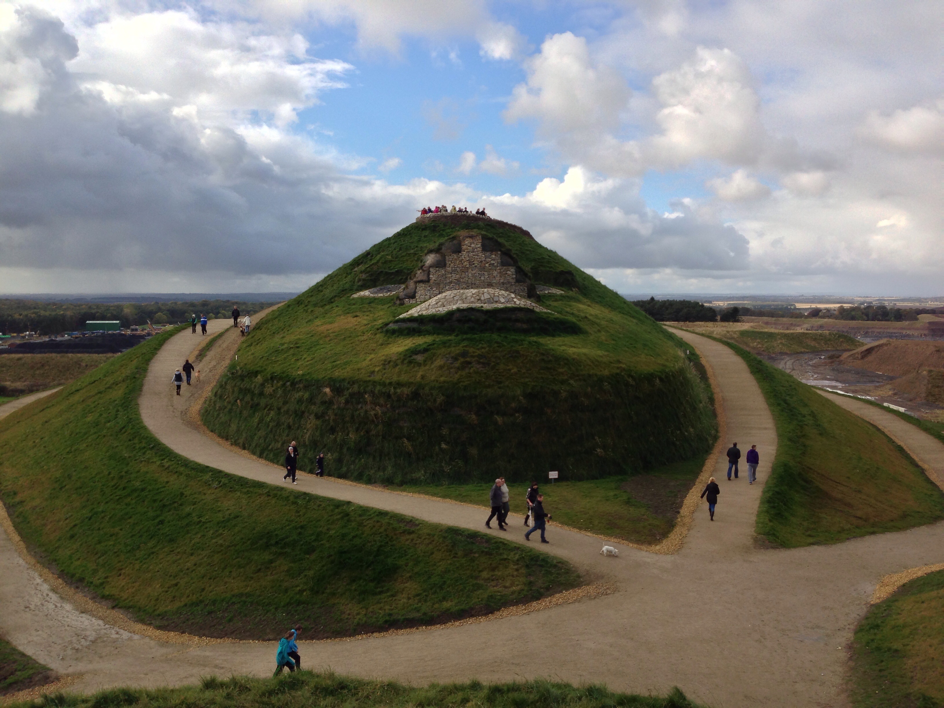
Northumberlandia

Northumberlandia (the "Lady of the North") is a huge land art sculpture in the shape of a reclining female figure, which was completed in 2012, near Cramlington...

St Mary's Hospital, Stannington

St Mary's Hospital was a mental health facility near Stannington, Northumberland, England. It was opened in 1910 and closed permanently in 1995. It was...

Nearby Amenities

Located within 500m of 55.09438,-1.6838315
Ewe Hill
Place: locality
Lat/Long: 55.0952891/-1.6808335
The data included in this document is from www.openstreetmap.org. The data is made available under ODbL.

Have you been to Blagdon Lake?

Leave your review of Blagdon Lake below (or comments, questions and feedback).