Crawley Reservoir

Lake, Pool, Pond, Freshwater Marsh in Durham

England

Crawley Reservoir

Stanhope Tree A preserved Sigillaria tree from the mid Carboniferous coal swamps. Instead of joining its coal friends it rotted away but was covered in sand which left a cast. <span class="nowrap"><a title="http://arthuride.files.wordpress.com/2010/12/sigillaria-tree1.jpg" rel="nofollow ugc noopener" href="http://arthuride.files.wordpress.com/2010/12/sigillaria-tree1.jpg">Link</a><img style="margin-left:2px;" alt="External link" title="External link - shift click to open in new window" src="https://s1.geograph.org.uk/img/external.png" width="10" height="10"/></span>

Preserved at a sand quarry it was brought here and erected in front of the church. The bark and root impressions are very good.
Stanhope Tree Credit: Ashley Dace

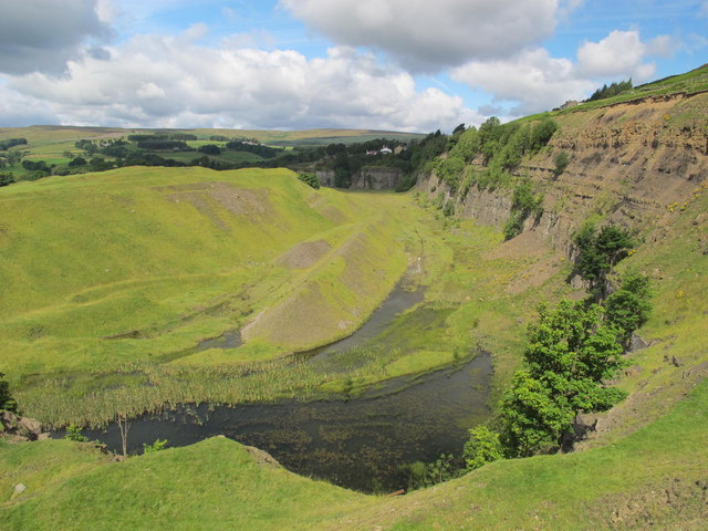
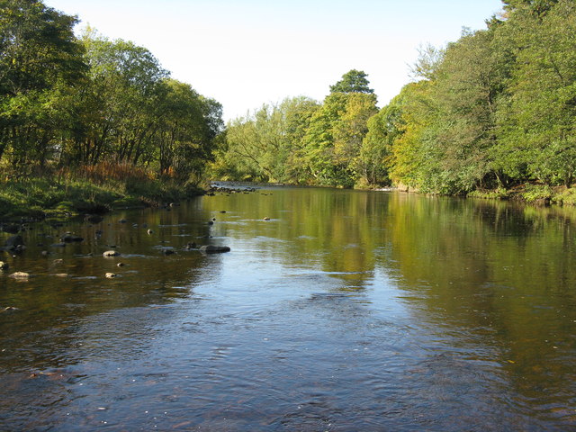
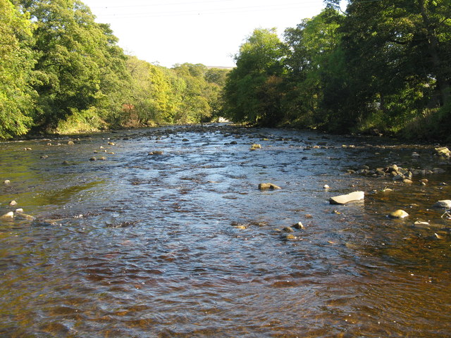
Crawley Reservoir, located in Durham, is a man-made freshwater reservoir that serves as a significant source of drinking water for the local community. Covering an approximate area of 50 acres, the reservoir is surrounded by beautiful natural landscapes and offers a range of recreational activities for visitors to enjoy.

Originally constructed in the early 1900s, Crawley Reservoir was designed to store water from the nearby river for domestic and industrial use. The reservoir's primary function is to ensure a reliable water supply for the region, contributing to the water security of the local population.

As a result of its purpose, the water within Crawley Reservoir is carefully monitored and maintained to ensure its quality. It serves as a habitat for various species of fish, including perch, pike, and roach, making it a popular spot for anglers seeking to engage in fishing activities.

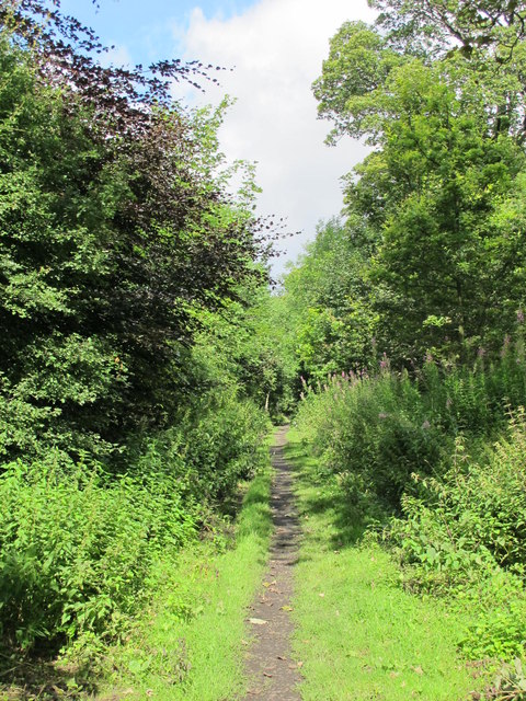
The surrounding area of the reservoir offers picturesque walking trails and picnic spots, attracting nature enthusiasts and families alike. The serene setting of Crawley Reservoir is also home to diverse wildlife, such as ducks, swans, and other waterfowl, providing an opportunity for birdwatchers to observe and appreciate the local avian population.

Visitors to Crawley Reservoir can engage in non-motorized water sports like kayaking and canoeing, taking advantage of the calm waters and scenic surroundings. The reservoir's tranquil ambiance and natural beauty make it a favored destination for those seeking a peaceful retreat or leisurely outdoor activities.

Overall, Crawley Reservoir in Durham serves as an essential water resource for the region while also providing recreational opportunities and a haven for wildlife and nature enthusiasts.

If you have any feedback on the listing, please let us know in the comments section below.

Crawley Reservoir Images

Images are sourced within 2km of 54.76351/-2.0089666 or Grid Reference NY9940. Thanks to Geograph Open Source API. All images are credited.

Stanhope Tree A preserved Sigillaria tree from the mid Carboniferous coal swamps. Instead of joining its coal friends it rotted away but was covered in sand which left a cast. <span class="nowrap"><a title="http://arthuride.files.wordpress.com/2010/12/sigillaria-tree1.jpg" rel="nofollow ugc noopener" href="http://arthuride.files.wordpress.com/2010/12/sigillaria-tree1.jpg">Link</a><img style="margin-left:2px;" alt="External link" title="External link - shift click to open in new window" src="https://s1.geograph.org.uk/img/external.png" width="10" height="10"/></span>

Preserved at a sand quarry it was brought here and erected in front of the church. The bark and root impressions are very good.
Stanhope Tree
A preserved Sigillaria tree from the mid Carboniferous coal swamps. Instead of joining its coal friends it rotted away but was covered in sand which left a cast. LinkExternal link Preserved at a sand quarry it was brought here and erected in front of the church. The bark and root impressions are very good.
St Thomas the Apostle Church, Stanhope The Church is an ancient structure, standing on the north side of the town. It is mainly of the Norman period, with its oldest portion being the lower stages of the tower. It consists of nave, aisles, chancel, south porch, and western tower. The chantry chapel at the east end of the south aisle, and dedicated to St. Mary, was probably added about 1225. (Carol Bleasdale)
St Thomas the Apostle Church, Stanhope
The Church is an ancient structure, standing on the north side of the town. It is mainly of the Norman period, with its oldest portion being the lower stages of the tower. It consists of nave, aisles, chancel, south porch, and western tower. The chantry chapel at the east end of the south aisle, and dedicated to St. Mary, was probably added about 1225. (Carol Bleasdale)
Stanhope Tree A preserved Sigillaria tree from the mid Carboniferous coal swamps. Instead of joining its coal friends it rotted away but was covered in sand which left a cast. <span class="nowrap"><a title="http://arthuride.files.wordpress.com/2010/12/sigillaria-tree1.jpg" rel="nofollow ugc noopener" href="http://arthuride.files.wordpress.com/2010/12/sigillaria-tree1.jpg">Link</a><img style="margin-left:2px;" alt="External link" title="External link - shift click to open in new window" src="https://s1.geograph.org.uk/img/external.png" width="10" height="10"/></span>

Preserved at a sand quarry it was brought here and erected in front of the church. The bark and root impressions are very good.
Stanhope Tree
A preserved Sigillaria tree from the mid Carboniferous coal swamps. Instead of joining its coal friends it rotted away but was covered in sand which left a cast. LinkExternal link Preserved at a sand quarry it was brought here and erected in front of the church. The bark and root impressions are very good.
The Church of St. Thomas, Stanhope Viewed from Church Lane.
The Church of St. Thomas, Stanhope
Viewed from Church Lane.
Ashes Quarry (2) The quarry was a mile long and was worked for over 70 years. The North Pennines AONB has produced a leaflet about the quarry that includes a 2 mile walk around the area <span class="nowrap"><a title="http://www.northpennines.org.uk/getmedia.cfm?mediaid=13093" rel="nofollow ugc noopener" href="http://www.northpennines.org.uk/getmedia.cfm?mediaid=13093">Link</a><img style="margin-left:2px;" alt="External link" title="External link - shift click to open in new window" src="https://s1.geograph.org.uk/img/external.png" width="10" height="10"/></span>.
Ashes Quarry (2)
The quarry was a mile long and was worked for over 70 years. The North Pennines AONB has produced a leaflet about the quarry that includes a 2 mile walk around the area LinkExternal link.
Ashes Quarry The quarry was a mile long and was worked for over 70 years. The North Pennines AONB has produced a leaflet about the quarry that includes a 2 mile walk around the area <span class="nowrap"><a title="http://www.northpennines.org.uk/getmedia.cfm?mediaid=13093" rel="nofollow ugc noopener" href="http://www.northpennines.org.uk/getmedia.cfm?mediaid=13093">Link</a><img style="margin-left:2px;" alt="External link" title="External link - shift click to open in new window" src="https://s1.geograph.org.uk/img/external.png" width="10" height="10"/></span>. See also <a href="https://www.geograph.org.uk/photo/2559354">NY9939 : Ashes Quarry (2)</a>.
Ashes Quarry
The quarry was a mile long and was worked for over 70 years. The North Pennines AONB has produced a leaflet about the quarry that includes a 2 mile walk around the area LinkExternal link. See also NY9939 : Ashes Quarry (2).
Trackbed of the former mineral railway between Ashes Quarry and Crawleyside See <a href="https://www.geograph.org.uk/photo/2559354">NY9939 : Ashes Quarry (2)</a>.
Trackbed of the former mineral railway between Ashes Quarry and Crawleyside
Wooden sleepers in the trackbed of the former mineral railway between Ashes Quarry and Crawleyside See <a href="https://www.geograph.org.uk/photo/2562753">NY9939 : Trackbed of the former mineral railway between Ashes Quarry and Crawleyside</a>.
Wooden sleepers in the trackbed of the former mineral railway between Ashes Quarry and Crawleyside
The ford at Stanhope
Stanhope ford and stepping stones A crossing of the River Wear, closed from October to March, and possibly quite scary at other times.
Stanhope ford and stepping stones
A crossing of the River Wear, closed from October to March, and possibly quite scary at other times.
Stepping stones across the Wear At the ford just south of the village.
Stepping stones across the Wear
At the ford just south of the village.
Unthank Hall, Stanhope A 16C Grade II* listed building in Weardale, apparently available for letting, according to my Googling.
Unthank Hall, Stanhope
A 16C Grade II* listed building in Weardale, apparently available for letting, according to my Googling.
The River Wear Looking upstream from the stepping stones across the river at Stanhope ford.
The River Wear
Looking upstream from the stepping stones across the river at Stanhope ford.
The River Wear at Stanhope Looking downstream from the stepping stones at the ford.
The River Wear at Stanhope
Looking downstream from the stepping stones at the ford.
Footpath up the Stanhope Burn The footpath up the west bank of the Stanhope Burn skirts the top of a steep wooded bank above the Burn.
Footpath up the Stanhope Burn
The footpath up the west bank of the Stanhope Burn skirts the top of a steep wooded bank above the Burn.
Ashes Quarry, Stanhope This massive limestone quarry on the hillside above Stanhope was worked for about 70 years from the late 19th century until the 1940s.
Ashes Quarry, Stanhope
This massive limestone quarry on the hillside above Stanhope was worked for about 70 years from the late 19th century until the 1940s.
Ashes Quarry, Stanhope This massive limestone quarry on the hillside above Stanhope was worked for about 70 years from the late 19th century until the 1940s. The village of Crawleyside Bank <a href="https://www.geograph.org.uk/gridref/NY9940">NY9940</a> can be seen in the middle distance.
Ashes Quarry, Stanhope
This massive limestone quarry on the hillside above Stanhope was worked for about 70 years from the late 19th century until the 1940s. The village of Crawleyside Bank NY9940 can be seen in the middle distance.
Show me another place!

Crawley Reservoir is located at Grid Ref: NY9940 (Lat: 54.76351, Lng: -2.0089666)

Unitary Authority: County Durham

Police Authority: Durham

What 3 Words

///royally.scavenger.plausible. Near Stanhope, Co. Durham

Related Wikis

Crawleyside

Crawleyside is a village in the civil parish of Stanhope, in County Durham, England. It is situated to the north of Stanhope, in Weardale. In the 2001...

Heathery Burn Cave

Heathery Burn Cave is a cave near Stanhope, County Durham, England, in which a large collection of Late Bronze Age weapons and tools was discovered and...

Weardale Rural District

Weardale was a rural district in County Durham, England from 1894 to 1974. It was formed under the Local Government Act 1894 as a successor to the Weardale...

Crawley railway station (Durham)

Crawley railway station served the village of Crawleyside, County Durham, England, from 1845 to 1846 on the Stanhope and Tyne Railway. == History == The...

Nearby Amenities

Located within 500m of 54.76351,-2.0089666
Barrier: cattle_grid
Lat/Long: 54.7603135/-2.0126328
Hunting Stand
Hunting Stand: grouse_butt
Lat/Long: 54.7616072/-2.0028377
Hunting Stand
Hunting Stand: grouse_butt
Lat/Long: 54.7612482/-2.0022744
Hunting Stand
Hunting Stand: grouse_butt
Lat/Long: 54.762008/-2.0021912
Hunting Stand
Hunting Stand: grouse_butt
Lat/Long: 54.7622355/-2.002615
Hunting Stand
Hunting Stand: grouse_butt
Lat/Long: 54.7624708/-2.0030496
Hunting Stand
Hunting Stand: grouse_butt
Lat/Long: 54.7627431/-2.0046374
Hunting Stand
Hunting Stand: grouse_butt
Lat/Long: 54.7626116/-2.0051524
Hunting Stand
Hunting Stand: grouse_butt
Lat/Long: 54.7624708/-2.0056888
Hunting Stand
Hunting Stand: grouse_butt
Lat/Long: 54.7623485/-2.0061743
Hunting Stand
Hunting Stand: grouse_butt
Lat/Long: 54.7622123/-2.0067108
Hunting Stand
Hunting Stand: grouse_butt
Lat/Long: 54.7620746/-2.0072579
Hunting Stand
Hunting Stand: grouse_butt
Lat/Long: 54.7619307/-2.0078051
Hunting Stand
Hunting Stand: grouse_butt
Lat/Long: 54.7617991/-2.0083174
Hunting Stand
Hunting Stand: grouse_butt
Lat/Long: 54.7616691/-2.008827
The data included in this document is from www.openstreetmap.org. The data is made available under ODbL.

Have you been to Crawley Reservoir?

Leave your review of Crawley Reservoir below (or comments, questions and feedback).