Black Pool

Lake, Pool, Pond, Freshwater Marsh in Worcestershire Wychavon

England

Black Pool

Farmland north of Ombersley Flat meadows as far as the eye can see
Farmland north of Ombersley Credit: Eirian Evans

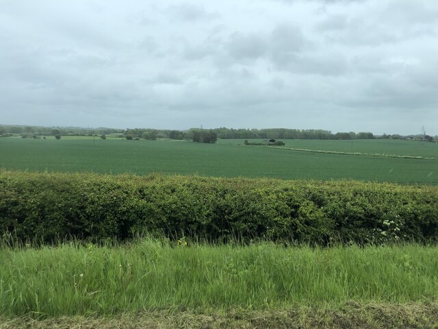
Black Pool is a picturesque freshwater lake located in Worcestershire, England. Situated within the expansive Worcester Woods Country Park, it covers an area of approximately 6 acres and is surrounded by lush greenery, making it a popular destination for nature lovers and outdoor enthusiasts alike.

The pool itself is characterized by its calm, still waters, which reflect the surrounding trees and create a serene and tranquil atmosphere. It is fed by natural springs and small streams, ensuring a constant supply of freshwater.

The lake is home to a diverse range of aquatic flora and fauna, with an abundance of water lilies, reeds, and other aquatic plants dotting its surface. This vibrant ecosystem attracts a variety of wildlife, including ducks, swans, herons, and kingfishers, making it a haven for birdwatchers.

The pool is also a great spot for fishing enthusiasts, with a healthy population of fish including carp, pike, and perch. Anglers can be seen casting their lines from the lakeshore or from small boats, enjoying the peacefulness and tranquility of the surroundings.

Surrounding Black Pool is a freshwater marsh, which acts as a natural buffer and provides additional habitat for a range of wetland species. The marshland is characterized by its reed beds, marsh marigolds, and other water-loving plants.

Visitors to Black Pool can explore the surrounding woodland, with numerous walking trails and picnic areas available. The lake itself offers opportunities for boating and canoeing, allowing visitors to fully immerse themselves in the natural beauty of this idyllic Worcestershire gem.

If you have any feedback on the listing, please let us know in the comments section below.

Black Pool Images

Images are sourced within 2km of 52.264221/-2.2325934 or Grid Reference SO8462. Thanks to Geograph Open Source API. All images are credited.

Farmland north of Ombersley Flat meadows as far as the eye can see
Farmland north of Ombersley
Flat meadows as far as the eye can see
Fields next to a footpath, near to Uphampton
Field boundary near Uphampton, Worcestershire
Walkers heading for Boreley House With the Abberley Hills in the distance.
Walkers heading for Boreley House
With the Abberley Hills in the distance.
Fish pond by The Wharf Inn, Holt Fleet
Houses at Holt Fleet from the riverside path (1)
Houses at Holt Fleet from the riverside path (2)
Autumnal trees across the river from Holt
Holt Castle from across the River Severn
Path from the River Severn to Ombersley
Looking across Ombersley Park With Ombersley Court and St Andrew Church.
Looking across Ombersley Park
With Ombersley Court and St Andrew Church.
Ombersley Court from the footpath by the fishponds
St Andrews Church, Ombersley from the South West
Holt Castle Grade I Listed building in Worcestershire. A fortified house with a 14th century tower.
Holt Castle
Grade I Listed building in Worcestershire. A fortified house with a 14th century tower.
Old Milestone, A449, South of Ombersley The milestone is located 20m north of the junction with the A4133 old road through Ombersley on the grass verge on the west side of the road. Parish of Ombersley (Wychavon District). Concrete post with replacement metal plate, Bradley post design, originally erected by the County Council in the 1930's. 

The original plate was stolen by professional thieves in April 2019, see <a title="https://www.geograph.org.uk/photo/6583401" href="https://www.geograph.org.uk/photo/6583401">Link</a> . The replacement plate was provided by the Milestone Society in October 2021, funded by a bequest from society member Rob Bubb of Kidderminster, being painstakingly installed by Worcestershire Highways staff, with additional refurbishment by the Ombersley and Doverdale Parish Council.

Inscription reads:-
A449 / STOURPORT 7 / C.C.W.

Milestone Society National ID: WO_SPWO07
Old Milestone, A449, South of Ombersley
The milestone is located 20m north of the junction with the A4133 old road through Ombersley on the grass verge on the west side of the road. Parish of Ombersley (Wychavon District). Concrete post with replacement metal plate, Bradley post design, originally erected by the County Council in the 1930's. The original plate was stolen by professional thieves in April 2019, see Link . The replacement plate was provided by the Milestone Society in October 2021, funded by a bequest from society member Rob Bubb of Kidderminster, being painstakingly installed by Worcestershire Highways staff, with additional refurbishment by the Ombersley and Doverdale Parish Council. Inscription reads:- A449 / STOURPORT 7 / C.C.W. Milestone Society National ID: WO_SPWO07
Tolley Memorial in the churchyard, Ombersley Early 19th century chest tomb commemorating Henry Godfrey Tolley, died 1822. Listed Grade II.
Tolley Memorial in the churchyard, Ombersley
Early 19th century chest tomb commemorating Henry Godfrey Tolley, died 1822. Listed Grade II.
Churchyard wall and gates, Ombersley These are c1830 and Listed Grade II.
Churchyard wall and gates, Ombersley
These are c1830 and Listed Grade II.
Pardoe Memorial, St Andrew's churchyard, Ombersley A disintegrating early 19th century chest tomb for Richard Pardoe, died 1807. Listed Grade II.
Pardoe Memorial, St Andrew's churchyard, Ombersley
A disintegrating early 19th century chest tomb for Richard Pardoe, died 1807. Listed Grade II.
Show me another place!

Black Pool is located at Grid Ref: SO8462 (Lat: 52.264221, Lng: -2.2325934)

Administrative County: Worcestershire

District: Wychavon

Police Authority: West Mercia

What 3 Words

///nation.crunches.koala. Near Fernhill Heath, Worcestershire

Nearby Locations

Black Pool

Related Wikis

Ombersley

Ombersley is a village and civil parish in Wychavon district, in the county of Worcestershire, England. The parish includes the hamlet of Holt Fleet,...

Holt, Worcestershire

Holt is a village and civil parish in the Malvern Hills District of the county of Worcestershire, England. The church is dedicated to St. Martin, and dates...

Ombersley and Doverdale

Ombersley and Doverdale is an area in Wychavon district, Worcestershire, England served by a single parish council but comprising the two separate civil...

Holt Fleet Bridge

Holt Fleet Bridge, also known as Holt Bridge, is a cast-iron arch bridge over the River Severn, at Holt in Worcestershire, England. It has a span of 150...

Hawford

Hawford is a hamlet in Worcestershire, England. It falls within two parishes; North Claines and Ombersley and Doverdale in the outer suburbs of Worcester...

Grimley, Worcestershire

Grimley is a village and civil parish (grid reference SO8360) in the Malvern Hills District in the county of Worcestershire, England about 3 miles (4...

Holt Heath, Worcestershire

Holt Heath, in the parish of Holt, is a village near the west bank of the River Severn in Worcestershire. The nearest towns are all about 6 miles away...

A449 road

The A449 is a major road in the United Kingdom. It runs north from junction 24 of the A48 road at Newport in South Wales to Stafford in Staffordshire....

Nearby Amenities

Located within 500m of 52.264221,-2.2325934
Bus Stop
A449 South Bound- Sinton
Bus: yes
Naptan AtcoCode: 2000G502397
Naptan Bearing: S
Naptan CommonName: A449 South Bound- Sinton
Naptan Indicator: Adj
Naptan Landmark: Moat Farm
Naptan NaptanCode: wocgmpmt
Naptan Street: Sinton
Naptan Verified: no
Public Transport: platform
Source: naptan_import
Lat/Long: 52.2647585/-2.227182
Bus Stop
Ombersley- A449 North Bound
Bus: yes
Naptan AtcoCode: 2000G502411
Naptan Bearing: N
Naptan CommonName: Ombersley- A449 North Bound
Naptan Indicator: Adj
Naptan Landmark: Ombersley Road
Naptan NaptanCode: wocdpwad
Naptan Street: Sinton
Naptan Verified: no
Public Transport: platform
Source: naptan_import
Lat/Long: 52.2647641/-2.228955
Barrier: stile
Lat/Long: 52.2648775/-2.2319677
Barrier: stile
Foot: yes
Lat/Long: 52.2631371/-2.239606
Barrier: stile
Foot: yes
Lat/Long: 52.2662163/-2.22682
Barrier: stile
Foot: yes
Lat/Long: 52.2655416/-2.2256186
Barrier: stile
Foot: yes
Lat/Long: 52.2674899/-2.2282811
Barrier: stile
Foot: yes
Lat/Long: 52.2615031/-2.2382591
Barrier: stile
Lat/Long: 52.2641552/-2.2255114
Sinton Farm
Location Transition: yes
Power: pole
Transformer: distribution
Voltage Primary: 11000
Lat/Long: 52.2657846/-2.2277925
The data included in this document is from www.openstreetmap.org. The data is made available under ODbL.

Have you been to Black Pool?

Leave your review of Black Pool below (or comments, questions and feedback).