Great Burstead

Settlement in Essex Basildon

England

Great Burstead

Sports field, White's Bridge
Sports field, White's Bridge Credit: JThomas

Great Burstead is a small village located in the county of Essex, England. Situated approximately 30 miles east of London, it is part of the Basildon district. The village is nestled in a rural setting, surrounded by beautiful countryside and farmland.

With a population of around 3,500 residents, Great Burstead retains its idyllic charm and close-knit community feel. It is a popular destination for those seeking a peaceful and picturesque place to live, away from the hustle and bustle of city life.

The village boasts a rich history, dating back to the Anglo-Saxon era. It is mentioned in the Domesday Book of 1086, where it is referred to as "Bursteada." Throughout the centuries, Great Burstead has been influenced by various architectural styles, resulting in a diverse range of buildings, including quaint cottages and grand manor houses.

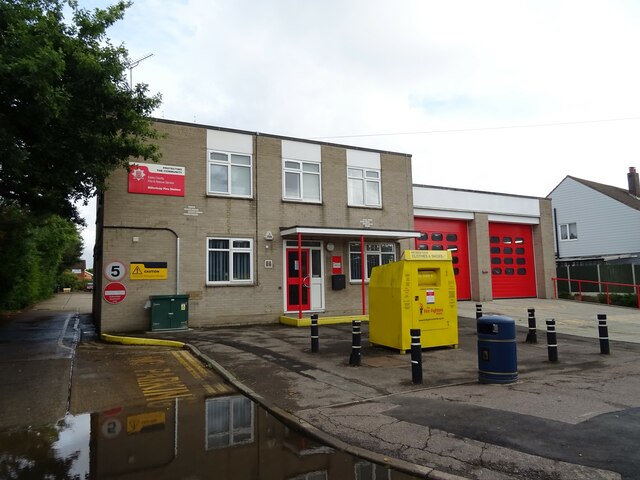
Great Burstead is well-served by amenities and facilities for its residents. The village is home to a primary school, a church, a post office, and several local shops and businesses. There are also several pubs and restaurants where residents and visitors can enjoy a meal or a drink.

For outdoor enthusiasts, Great Burstead offers plenty of opportunities to explore the surrounding countryside. The village is located near to various nature reserves and parks, providing ample space for walking, cycling, and other outdoor activities.

Overall, Great Burstead is a charming and peaceful village, offering a rural escape while still providing easy access to nearby urban centers. Its rich history, strong sense of community, and beautiful surroundings make it a desirable place to live or visit.

If you have any feedback on the listing, please let us know in the comments section below.

Great Burstead Images

Images are sourced within 2km of 51.605647/0.430715 or Grid Reference TQ6892. Thanks to Geograph Open Source API. All images are credited.

Sports field, White's Bridge
Billericay Fire Station On Laindon Road.
Billericay Fire Station
On Laindon Road.
2nd Billericay Scout Group Hall On Laindon Road.
2nd Billericay Scout Group Hall
On Laindon Road.
Reids Bar & Restaurant, Billericay On Laindon Road.
Reids Bar & Restaurant, Billericay
On Laindon Road.
Laindon Road (A176)
Laindon Road (A176)
Stubble field off Southend Road
Southend Road (A129)
Footpath 200 to White's Bridge Footpath 200 crosses a number of sports fields in this area.
Footpath 200 to White's Bridge
Footpath 200 crosses a number of sports fields in this area.
Footpath to Gurnard's Farm The farm road to <a href="https://www.geograph.org.uk/photo/3053332">TQ6992 : Gunard's Farm</a> is footpath 37
Footpath to Gurnard's Farm
The farm road to TQ6992 : Gunard's Farm is footpath 37
Sunday football refreshments at Barleylands Large flat field. Large local population. Football for the masses, starting as young as 5. A huge field accommodating many football pitches for children of all ages, sufficient to justify a mobile catering van for doting adult supporters.
Sunday football refreshments at Barleylands
Large flat field. Large local population. Football for the masses, starting as young as 5. A huge field accommodating many football pitches for children of all ages, sufficient to justify a mobile catering van for doting adult supporters.
Barleylands Football pitches By White's Farm, Sunday morning
Barleylands Football pitches
By White's Farm, Sunday morning
Little Burstead, Essex Looking west towards the village green. The building in the centre is the old village school built in 1891.
Little Burstead, Essex
Looking west towards the village green. The building in the centre is the old village school built in 1891.
Dukes Head Public House, Little Burstead, Essex Situated on the south side of Laindon Common, the Dukes Head looks more like a late Victorian railway station than a pub!
Dukes Head Public House, Little Burstead, Essex
Situated on the south side of Laindon Common, the Dukes Head looks more like a late Victorian railway station than a pub!
Barleylands Farm - Billericay Here we see just setting up for the annual country show some threshing machines and traction engines.
Barleylands Farm - Billericay
Here we see just setting up for the annual country show some threshing machines and traction engines.
Noak Bridge, Basildon, Essex Junction of Noak Hill Road and Dunton Road
Noak Bridge, Basildon, Essex
Junction of Noak Hill Road and Dunton Road
Fields at Barleylands Farm, Great Burstead, Essex Looking north-west from Southend Road towards Great Burstead.
Fields at Barleylands Farm, Great Burstead, Essex
Looking north-west from Southend Road towards Great Burstead.
Great Burstead Parish Church, Essex A medieval church, mainly built in the 14th/15th centuries. It dates back to Norman times and the nave window dates back to this time. The tower & steeple are 14th century and constructed of Kentish Ragstone.
Great Burstead Parish Church, Essex
A medieval church, mainly built in the 14th/15th centuries. It dates back to Norman times and the nave window dates back to this time. The tower & steeple are 14th century and constructed of Kentish Ragstone.
Traditional Essex Weatherboard Barn, near Billericay This barn is located near Brown's Farm in Coxes Farm Road
Traditional Essex Weatherboard Barn, near Billericay
This barn is located near Brown's Farm in Coxes Farm Road
Show me another place!

Great Burstead is located at Grid Ref: TQ6892 (Lat: 51.605647, Lng: 0.430715)

Administrative County: Essex

District: Basildon

Police Authority: Essex

What 3 Words

///water.always.rents. Near Billericay, Essex

Related Wikis

Burstead Grange

Burstead Grange was a priory in Essex, England. == References ==

Great Burstead and South Green

Great Burstead and South Green is a civil parish in the Basildon district, in the county of Essex, England. The parish includes the settlements of Great...

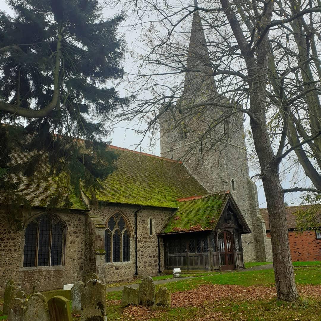
St Mary Magdalene, Great Burstead

St Mary Magdalene is a Grade I-listed parish church in the village of Great Burstead, about 1.5 mi (2.4 km) south of Billericay, Essex, England. The present...

Basildon and Billericay (UK Parliament constituency)

Basildon and Billericay () is a constituency in Essex represented in the House of Commons of the UK Parliament. Since its 2010 creation it has been represented...

Nearby Amenities

Located within 500m of 51.605647,0.430715
Bus Stop
Homefield Close
Naptan AtcoCode: 150007001002
Naptan Bearing: E
Naptan CommonName: Homefield Close
Naptan Crossing: Homefield Close
Naptan Indicator: Opp
Naptan Landmark: Homefield Close
Naptan NaptanCode: esxagwmw
Naptan PlusbusZoneRef: BILERCY
Naptan Street: Mill Road
Naptan Verified: no
Public Transport: platform
Source: naptan_import
Lat/Long: 51.6082084/0.4363273
Bus Stop
Kennel Lane
Naptan AtcoCode: 150007001005
Naptan Bearing: NE
Naptan CommonName: Kennel Lane
Naptan Crossing: Kennel Lane
Naptan Indicator: Adj
Naptan Landmark: Kennel Lane
Naptan NaptanCode: esxagwpg
Naptan PlusbusZoneRef: BILERCY
Naptan Street: Church Street
Naptan Verified: no
Public Transport: platform
Source: naptan_import
Lat/Long: 51.6058443/0.4275926
Bus Stop
Kennel Lane
Naptan AtcoCode: 150007001006
Naptan Bearing: SW
Naptan CommonName: Kennel Lane
Naptan Crossing: Kennel Lane
Naptan Indicator: Opp
Naptan Landmark: Kennel Lane
Naptan NaptanCode: esxagwpj
Naptan PlusbusZoneRef: BILERCY
Naptan Street: Church Street
Naptan Verified: no
Public Transport: platform
Source: naptan_import
Lat/Long: 51.605458/0.4276125
Bus Stop
Church
Naptan AtcoCode: 1500IM197
Naptan Bearing: SW
Naptan CommonName: Church
Naptan Indicator: Adj
Naptan Landmark: Church
Naptan NaptanCode: esxagwpt
Naptan PlusbusZoneRef: BASILDN;BILERCY
Naptan Street: Church Street
Naptan Verified: no
Public Transport: platform
Source: naptan_import
Lat/Long: 51.6037325/0.4249796
Bus Stop
Church
Naptan AtcoCode: 1500IM197B
Naptan Bearing: NE
Naptan CommonName: Church
Naptan Indicator: Opp
Naptan Landmark: Church
Naptan NaptanCode: esxagwpm
Naptan PlusbusZoneRef: BASILDN;BILERCY
Naptan Street: Church Street
Naptan Verified: no
Public Transport: platform
Source: naptan_import
Lat/Long: 51.6037215/0.4244006
Bus Stop
Grange Road
Naptan AtcoCode: 1500IM2375
Naptan Bearing: SW
Naptan CommonName: Grange Road
Naptan Crossing: Grange Road
Naptan Indicator: Opp
Naptan Landmark: Grange Road
Naptan NaptanCode: esxagwpd
Naptan PlusbusZoneRef: BILERCY
Naptan Street: Mill Road
Naptan Verified: no
Public Transport: platform
Source: naptan_import
Lat/Long: 51.6075844/0.4338962
Bus Stop
Grange Road
Naptan AtcoCode: 1500IM2375B
Naptan Bearing: E
Naptan CommonName: Grange Road
Naptan Crossing: Grange Road
Naptan Indicator: Adj
Naptan Landmark: Grange Road
Naptan NaptanCode: esxagwpa
Naptan PlusbusZoneRef: BILERCY
Naptan Street: Mill Road
Naptan Verified: no
Public Transport: platform
Source: naptan_import
Lat/Long: 51.6077056/0.4341194
The data included in this document is from www.openstreetmap.org. The data is made available under ODbL.

Have you been to Great Burstead?

Leave your review of Great Burstead below (or comments, questions and feedback).