Loch of Lakequoy

Lake, Pool, Pond, Freshwater Marsh in Orkney

Scotland

Loch of Lakequoy

Country road at Cobrance Farm
Country road at Cobrance Farm Credit: Oliver Dixon

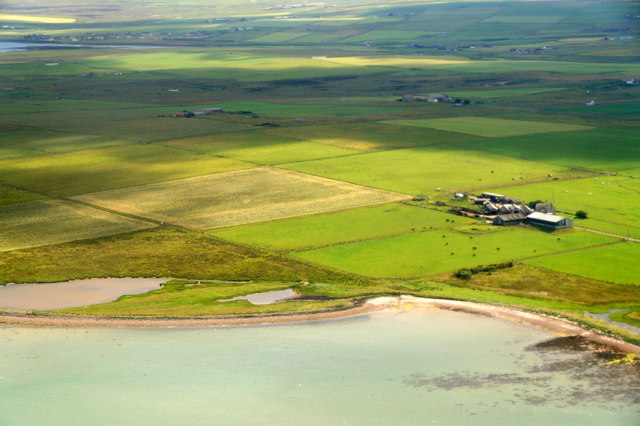
Loch of Lakequoy is a freshwater body located in Orkney, an archipelago in the northern part of Scotland. Situated on the Mainland, the largest island in the group, this loch is known for its scenic beauty and rich biodiversity. Spanning an area of approximately 40 acres, it serves as a vital habitat for various aquatic plants and animals.

The Loch of Lakequoy is a shallow body of water, with a maximum depth of around 10 feet. It is surrounded by gently sloping grassland and marshes, which provide a suitable environment for numerous bird species. The loch is particularly renowned as a breeding ground for waterfowl, including ducks, geese, and swans.

The diverse vegetation around the loch includes reeds, rushes, and water lilies, which thrive in the nutrient-rich waters. These plants not only enhance the natural beauty of the loch but also play a crucial role in maintaining the ecological balance. Additionally, they provide food and shelter for many species of insects, amphibians, and fish.

Loch of Lakequoy is a popular destination for birdwatchers and nature enthusiasts, offering excellent opportunities for observing and photographing the local wildlife. Visitors can often spot rare species such as the great crested grebe, little grebe, and teal, among others. The loch is also a designated Site of Special Scientific Interest (SSSI), recognizing its importance for conservation.

Overall, Loch of Lakequoy is a picturesque freshwater body that showcases the natural wonders of Orkney. Its tranquil waters, lush vegetation, and diverse birdlife make it a haven for both wildlife and those seeking a peaceful escape in nature.

If you have any feedback on the listing, please let us know in the comments section below.

Loch of Lakequoy Images

Images are sourced within 2km of 58.959633/-2.8399079 or Grid Reference HY5108. Thanks to Geograph Open Source API. All images are credited.

Country road at Cobrance Farm
Cott of Holland Farm on the Tankerness peninsula.
Cott of Holland
Farm on the Tankerness peninsula.
Road, Yinstay A rather wide verge in Tankerness.
Road, Yinstay
A rather wide verge in Tankerness.
Messigate, Tankerness, from the air Loch of Messigate on the left and Mill Sand in the foreground.
Messigate, Tankerness, from the air
Loch of Messigate on the left and Mill Sand in the foreground.
Jewellery workshop Orkney has a rich jewellery heritage, from the early designs of Ola Gorie (the first to produce jewellery here since Viking times) to popular local producers Sheila Fleet, Aurora Orkney, Ortak and several smaller firms. Mainland Orkney is home to several of these jewellery manufacturers; this is the headquarters of the Sheila Fleet jewellery business.
Jewellery workshop
Orkney has a rich jewellery heritage, from the early designs of Ola Gorie (the first to produce jewellery here since Viking times) to popular local producers Sheila Fleet, Aurora Orkney, Ortak and several smaller firms. Mainland Orkney is home to several of these jewellery manufacturers; this is the headquarters of the Sheila Fleet jewellery business.
Delicate craftmanship A girl applying rainbow enamel colouring to a ring in the Sheila Fleet atelier in Tankerness.
Delicate craftmanship
A girl applying rainbow enamel colouring to a ring in the Sheila Fleet atelier in Tankerness.
Showroom at the atelier Jewellery showroom and shop at the Sheila Fleet factory,
Showroom at the atelier
Jewellery showroom and shop at the Sheila Fleet factory,
Mill Sand With the tide in.
Mill Sand
With the tide in.
Willow Vale, Tankerness House at a T-junction close to a land-fill site.
Willow Vale, Tankerness
House at a T-junction close to a land-fill site.
White horses With the Loch of Tankerness in the background.
White horses
With the Loch of Tankerness in the background.
St. Andrew's Kirk, Tankerness St. Andrew's Kirk (North Church) Church of Scotland, Tankerness. Historic Scotland C Listed ID 352630. Built 1801, enlarged 1827.
St. Andrew's Kirk, Tankerness
St. Andrew's Kirk (North Church) Church of Scotland, Tankerness. Historic Scotland C Listed ID 352630. Built 1801, enlarged 1827.
Tankerness Meal Mill Meal Mill. Historic Scotland B Listed (Ident-18567). Early 19th Century.

2-storey, 5-bay T-plan asymmetrical mill with slightly raised kiln at E end and undershot water wheel at W. Harl-pointed rubble. Long and short quoins to kiln. The tall blocked arches mark the position of the original wheel before it was placed on the outside of the end wall.

3 pairs of stones were driven by a high-breast wheel about 4.3m in diameter and, in order that the movement of the wheel did not startle horses passing over the adjacent bridge, it was shielded by a screen wall.(Historic Scotland)
Tankerness Meal Mill
Meal Mill. Historic Scotland B Listed (Ident-18567). Early 19th Century. 2-storey, 5-bay T-plan asymmetrical mill with slightly raised kiln at E end and undershot water wheel at W. Harl-pointed rubble. Long and short quoins to kiln. The tall blocked arches mark the position of the original wheel before it was placed on the outside of the end wall. 3 pairs of stones were driven by a high-breast wheel about 4.3m in diameter and, in order that the movement of the wheel did not startle horses passing over the adjacent bridge, it was shielded by a screen wall.(Historic Scotland)
Hall of Tankerness, from the air
Houses at Tankerness, from the air
Houses at Bossack, Tankerness, from the air
Tankerness farmland Wet and rashy, fields beside the Loch of Tankerness.
Tankerness farmland
Wet and rashy, fields beside the Loch of Tankerness.
Farm track, Tankerness Hopefully the walkway sign means that you won't meet three strands of barbed wire along the way.
Farm track, Tankerness
Hopefully the walkway sign means that you won't meet three strands of barbed wire along the way.
Tankerness: the grass is stirring A hint of future growth in a late Spring, view towards Loch of Tankerness.
Tankerness: the grass is stirring
A hint of future growth in a late Spring, view towards Loch of Tankerness.
Show me another place!

Loch of Lakequoy is located at Grid Ref: HY5108 (Lat: 58.959633, Lng: -2.8399079)

Unitary Authority: Orkney Islands

Police Authority: Highlands and Islands

What 3 Words

///impressed.scrum.fried. Near Tankerness, Orkney Islands

Related Wikis

Loch of Tankerness

Loch of Tankerness is a large, lowland, freshwater loch on the Orkney mainland in Scotland. The loch is roughly triangular in shape and is shallow with...

Tankerness

Tankerness is a district in the St Andrews parish in Mainland, Orkney, Scotland. Essentially a peninsula, it is about 13 kilometres (8 mi) south-east of...

St Andrews, Orkney

St Andrews is a parish on Mainland, Orkney in Scotland. It is located east of the town of Kirkwall and the parish of St Ola and lies north of Holm and...

Toab, Orkney

Toab is a parish on the Orkney Mainland, situated in the East Mainland. Toab is located off the A960 road at the head of Deer Sound on the Mainland, Orkney...

Nearby Amenities

Located within 500m of 58.959633,-2.8399079
Skerries of Lakeqooy
Place: locality
Lat/Long: 58.9583703/-2.8339385
Gritquoy Ayre
Place: locality
Lat/Long: 58.9586469/-2.840762
Passing Place
Lat/Long: 58.9636283/-2.8403453
Passing Place
Lat/Long: 58.9612598/-2.8456612
Tankerness Mill - early C19 watermill, overshot,
Addr City: Tankerness, Orkney
Man Made: watermill
Lat/Long: 58.9613776/-2.845855
Power: pole
Lat/Long: 58.9626286/-2.8335267
Power: pole
Lat/Long: 58.9630653/-2.8344215
Power: pole
Lat/Long: 58.9628359/-2.8356229
Power: pole
Lat/Long: 58.9625806/-2.8369476
Power: pole
Lat/Long: 58.9623331/-2.8381691
Power: pole
Lat/Long: 58.9620908/-2.8394309
Power: pole
Lat/Long: 58.9618704/-2.840577
Power: pole
Lat/Long: 58.9616346/-2.8417911
Power: pole
Lat/Long: 58.961448/-2.842716
Power: pole
Lat/Long: 58.9611965/-2.8440406
Power: pole
Lat/Long: 58.9609205/-2.8454029
Power: pole
Lat/Long: 58.9607079/-2.8465541
Power: pole
Lat/Long: 58.96045/-2.8478787
The data included in this document is from www.openstreetmap.org. The data is made available under ODbL.

Have you been to Loch of Lakequoy?

Leave your review of Loch of Lakequoy below (or comments, questions and feedback).