Goose Island Pond
Lake, Pool, Pond, Freshwater Marsh in Lancashire West Lancashire
England
Goose Island Pond

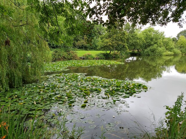
Goose Island Pond, located in Lancashire, is a picturesque freshwater body formed by a combination of natural processes and human intervention. Spanning an area of approximately 10 acres, the pond offers a serene and tranquil environment for both wildlife and visitors alike.
The pond is characterized by a diverse range of habitats, including open water, marshes, and reed beds. These habitats support a rich variety of flora and fauna, making Goose Island Pond an important ecological site. The surrounding vegetation is predominantly composed of water lilies, bulrushes, and various species of reeds, providing shelter and nesting sites for a plethora of bird species.
Speaking of avifauna, Goose Island Pond is a haven for numerous waterfowl species. Visitors can often spot graceful swans gliding on the calm waters, elegant mallards dabbling for food, and the occasional great crested grebe diving for fish. The pond also attracts a variety of migratory birds during different seasons, including tufted ducks, coots, and herons.
The pond's accessibility is enhanced by a network of footpaths and viewing points, allowing visitors to explore and enjoy the beauty of the area. It is a popular spot for birdwatching, photography, and nature enthusiasts seeking a peaceful retreat. Additionally, fishing is permitted in the pond, providing anglers with opportunities to catch species such as carp, tench, and roach.
Managed by local conservation groups, Goose Island Pond is actively maintained to ensure the preservation of its natural beauty and the sustainability of its wildlife population. The site offers an invaluable opportunity for residents and visitors to connect with nature and appreciate the wonders of Lancashire's freshwater ecosystems.
If you have any feedback on the listing, please let us know in the comments section below.
Goose Island Pond Images
Images are sourced within 2km of 53.570482/-2.8130386 or Grid Reference SD4608. Thanks to Geograph Open Source API. All images are credited.


Goose Island Pond is located at Grid Ref: SD4608 (Lat: 53.570482, Lng: -2.8130386)
Administrative County: Lancashire
District: West Lancashire
Police Authority: Lancashire
What 3 Words
///floating.pickle.haystack. Near Burscough, Lancashire
Nearby Locations
Related Wikis

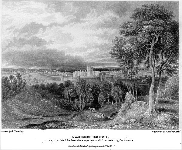
Lathom House
Lathom House was a large country house in the parish of Lathom in Lancashire, England. Built between 1725 and 1740, the main block was demolished in 1925...
Siege of Lathom House
The siege of Lathom House was a military confrontation between a Parliamentarian army and a Royalist stronghold in Lathom near Ormskirk in Lancashire,...

West Lancashire (UK Parliament constituency)
West Lancashire is a county constituency represented in the House of Commons of the UK Parliament. Following the resignation of Labour MP Rosie Cooper...

West Lancashire
West Lancashire is a local government district with borough status in Lancashire, England. The council is based in Ormskirk, and the largest town is Skelmersdale...
Related Videos

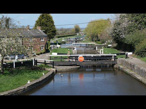
Walking Along Leeds Liverpool Canal Rufford Branch, Lathom, Burscough Ormskirk England 27th May 2023
An afternoon walk around Leeds Liverpool Canal Rufford Branch (including Top Lock Bridge Lock 1), Lathom/Burscough ...

St Marks War Horse
West Lancashire Walking.
Ship Inn to Rufford and back along the Leeds and Liverpool Canal
Walking along the canal towpath.

Jellyhead (Trip to Burscough)
My trip to the small town of Burscough near Ormskirk was a nice one. The town centre which also had the name "Burscough ...
Nearby Amenities
Located within 500m of 53.570482,-2.8130386Have you been to Goose Island Pond?
Leave your review of Goose Island Pond below (or comments, questions and feedback).