Dunsapie Loch

Lake, Pool, Pond, Freshwater Marsh in Midlothian

Scotland

Dunsapie Loch

Duddingston Road, Edinburgh Looking along Duddingston Road, Edinburgh. A residential street lined mainly by bungalows on the left, the local high school is out of shot on the right.
Duddingston Road, Edinburgh Credit: Graham Robson

Dunsapie Loch is a picturesque freshwater loch located in Midlothian, Scotland. Situated in the heart of Holyrood Park, adjacent to the famous Arthur's Seat, this natural water body is a popular destination for locals and tourists alike.

Covering an area of approximately 1.5 hectares, Dunsapie Loch is often referred to as a lake, pool, or pond due to its small size. It is surrounded by lush greenery, providing a serene and tranquil setting for visitors to enjoy. The loch is fed by natural springs and rainwater runoff, ensuring a constant flow of fresh water.

The shoreline of Dunsapie Loch is lined with reeds and other aquatic plants, creating a diverse habitat for various species of wildlife. The loch is particularly renowned for its birdlife, with a wide variety of waterfowl, such as swans, ducks, and coots, making it their home. Birdwatchers flock to the area to observe these fascinating creatures in their natural habitat.

Additionally, Dunsapie Loch is a haven for anglers who enjoy fishing in its calm waters. The loch is stocked with brown trout, making it a prime spot for anglers to try their luck at catching these fish.

Surrounded by rolling hills and offering stunning panoramic views of the surrounding landscape, Dunsapie Loch is a popular spot for leisurely walks and picnics. Visitors can explore the nearby walking trails or simply relax on the banks of the loch, taking in the peaceful ambiance.

Overall, Dunsapie Loch is a hidden gem within the beautiful Midlothian region, offering a tranquil escape for nature enthusiasts, anglers, and those seeking a peaceful retreat amidst stunning natural scenery.

If you have any feedback on the listing, please let us know in the comments section below.

Dunsapie Loch Images

Images are sourced within 2km of 55.946121/-3.1530805 or Grid Reference NT2873. Thanks to Geograph Open Source API. All images are credited.

Duddingston Road, Edinburgh Looking along Duddingston Road, Edinburgh. A residential street lined mainly by bungalows on the left, the local high school is out of shot on the right.
Duddingston Road, Edinburgh
Looking along Duddingston Road, Edinburgh. A residential street lined mainly by bungalows on the left, the local high school is out of shot on the right.
Possible OSBM pivot
Possible OSBM pivot
New use for an old train wheelset In Figgate Park Virgin East Coast Trains (whose Craigentinny Train Depot is close to the park) have provided old train wheelsets for imaginative new uses
New use for an old train wheelset
In Figgate Park Virgin East Coast Trains (whose Craigentinny Train Depot is close to the park) have provided old train wheelsets for imaginative new uses
Recycled Train Wheels This piece of utilitarian environmental art is a reminder of the extensive railway lines and sheds that once existed her.
Recycled Train Wheels
This piece of utilitarian environmental art is a reminder of the extensive railway lines and sheds that once existed her.
Bench on Wheels The axle of an old set of train wheels supports a park bench, commemorating the railway sheds that one stood nearby.
Bench on Wheels
The axle of an old set of train wheels supports a park bench, commemorating the railway sheds that one stood nearby.
Train wheels on display, Figgate Burn Park Two sets of train wheels in use as bird feeders and a bench seat overlooking the pond. The East Coast main line is nearby, along with a Virgin Trains depot.
Train wheels on display, Figgate Burn Park
Two sets of train wheels in use as bird feeders and a bench seat overlooking the pond. The East Coast main line is nearby, along with a Virgin Trains depot.
Duddingston Road
Duddingston Road
Climbing Boulder, Treverlen Park This is quite a park! It opened in late 2019 and occupies the land formerly occupied by a high school and a primary school. The deal seems to have been that since the new schools were pinching recreational land, the land the former schools were sitting on would be turned into recreational land, therefore keeping the division of land the same.
At first I assumed this was a sculpture, which did strike me as rather odd, given the park's residential location. It was the ground surrounding the boulder - which is actually two boulders joined by a Stonehenge-ish horizontal section - that gave it away. It's that bouncy stuff that's been around for ages now, there to minimise cuts and bruises when the inevitable happens on climbing apparatus. It is extremely well designed as some sides look easier to climb than others. I went up by what was definitely the easiest ascent and still got a bit stressed coming back down, despite the bouncy ground and the top only being about 10 feet high!
Websites do give the reason for the park's odd name but it's all a bit hard to fathom. There seems to be some ongoing dispute between the locals and the council about park names - Portobello Park gets mentioned but the dispute looked too exhausting to get into the guts of it. So 'Treverlen', which might or might not be a name given to this area when there was nothing here but bogland in the Middle Ages, was settled on as nobody could take offence. That's my take on it all anyway!
Climbing Boulder, Treverlen Park
This is quite a park! It opened in late 2019 and occupies the land formerly occupied by a high school and a primary school. The deal seems to have been that since the new schools were pinching recreational land, the land the former schools were sitting on would be turned into recreational land, therefore keeping the division of land the same. At first I assumed this was a sculpture, which did strike me as rather odd, given the park's residential location. It was the ground surrounding the boulder - which is actually two boulders joined by a Stonehenge-ish horizontal section - that gave it away. It's that bouncy stuff that's been around for ages now, there to minimise cuts and bruises when the inevitable happens on climbing apparatus. It is extremely well designed as some sides look easier to climb than others. I went up by what was definitely the easiest ascent and still got a bit stressed coming back down, despite the bouncy ground and the top only being about 10 feet high! Websites do give the reason for the park's odd name but it's all a bit hard to fathom. There seems to be some ongoing dispute between the locals and the council about park names - Portobello Park gets mentioned but the dispute looked too exhausting to get into the guts of it. So 'Treverlen', which might or might not be a name given to this area when there was nothing here but bogland in the Middle Ages, was settled on as nobody could take offence. That's my take on it all anyway!
Durham Drive
Durham Drive
Durham Drive
Durham Drive
Duddingston Loch This loch was formed as a crater of an ancient volcano. It is a popular wintering place for wildfowl
Duddingston Loch
This loch was formed as a crater of an ancient volcano. It is a popular wintering place for wildfowl
Auld Reekie A winter sunset picks out the gables of tenements at the foot of Arthur's Seat in Edinburgh
Auld Reekie
A winter sunset picks out the gables of tenements at the foot of Arthur's Seat in Edinburgh
Arthur's Seat Close up  of a famous landmark, the 251m high craggy hill in the centre of Edinburgh.
Arthur's Seat
Close up of a famous landmark, the 251m high craggy hill in the centre of Edinburgh.
Gorse on Arthur's Seat Gorse covers a lot of the hill and can be glorious in flower. Looking over the flowers down to Duddingston Loch.
Gorse on Arthur's Seat
Gorse covers a lot of the hill and can be glorious in flower. Looking over the flowers down to Duddingston Loch.
Albion Place Easter Road stadium (Hibernian FC) above Albion Place. To the right is the building that once housed the Lockhart Memorial Church.
Albion Place
Easter Road stadium (Hibernian FC) above Albion Place. To the right is the building that once housed the Lockhart Memorial Church.
Bowls, Restalrig A popular Scottish pastime on a fortified green in this  East Edinburgh housing scheme, built on the site of an old village.
Bowls, Restalrig
A popular Scottish pastime on a fortified green in this East Edinburgh housing scheme, built on the site of an old village.
Dunsapie Crag and Loch Dunsapie Crag is a rocky hill in Holyrood Park and the site of an iron age hillfort. Its moated by the artificial Dunsapie Loch, currently home to nesting swans.
Dunsapie Crag and Loch
Dunsapie Crag is a rocky hill in Holyrood Park and the site of an iron age hillfort. Its moated by the artificial Dunsapie Loch, currently home to nesting swans.
St Anthony's Chapel Winter sunlight in Holyrood Park.
St Anthony's Chapel
Winter sunlight in Holyrood Park.
Show me another place!

Dunsapie Loch is located at Grid Ref: NT2873 (Lat: 55.946121, Lng: -3.1530805)

Unitary Authority: City of Edinburgh

Police Authority: Edinburgh

What 3 Words

///jets.wipe.files. Near Edinburgh

Nearby Locations

Dunsapie Loch Willowbrae

Related Wikis

Holyrood Park

Holyrood Park (also called the King's Park or Queen's Park depending on the reigning monarch's gender) is a royal park in central Edinburgh, Scotland about...
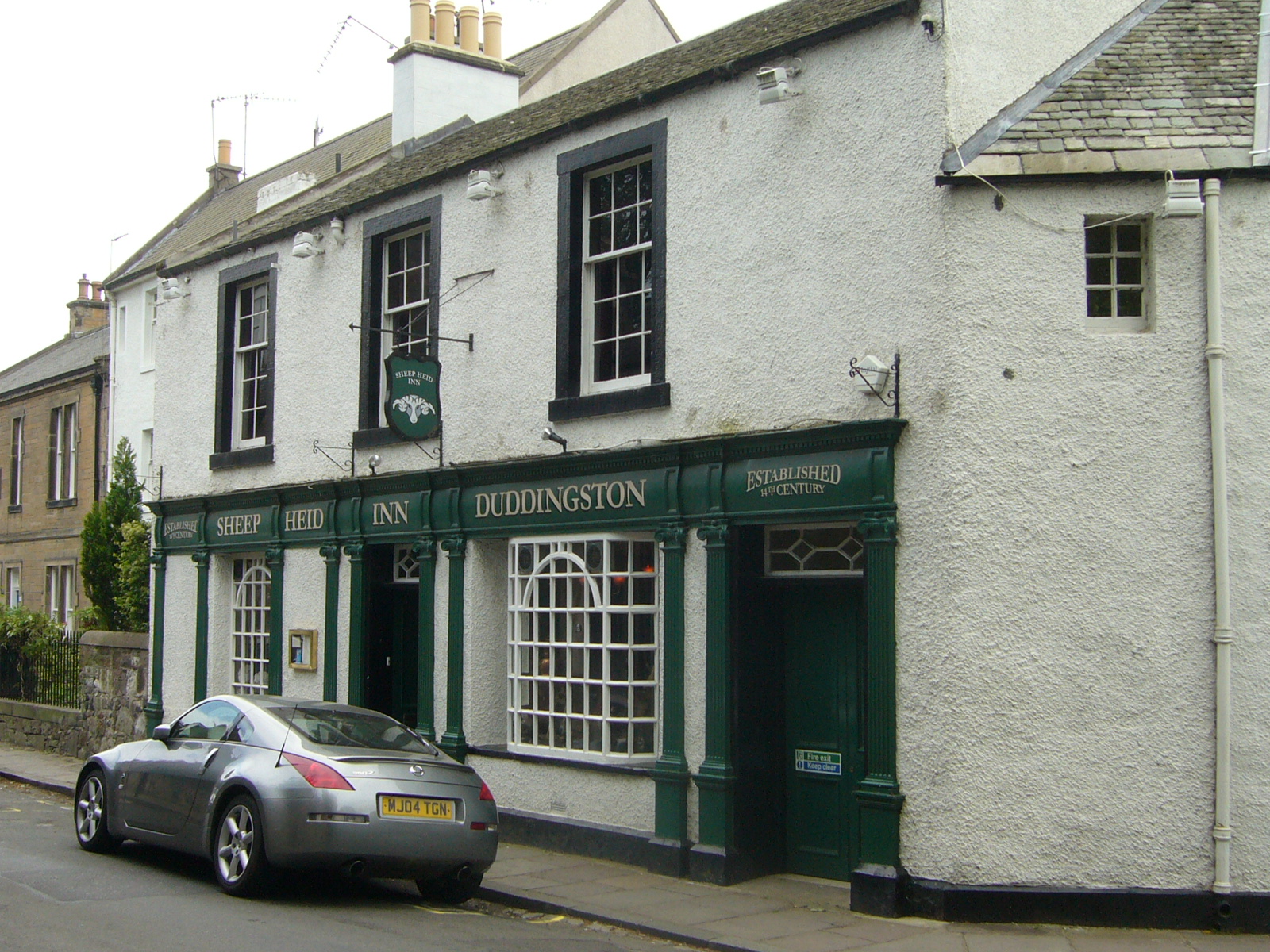
Sheep Heid Inn

The Sheep Heid Inn is a public house in Duddingston, Edinburgh, Scotland. There has reputedly been an inn on this site since 1360, although the core of...
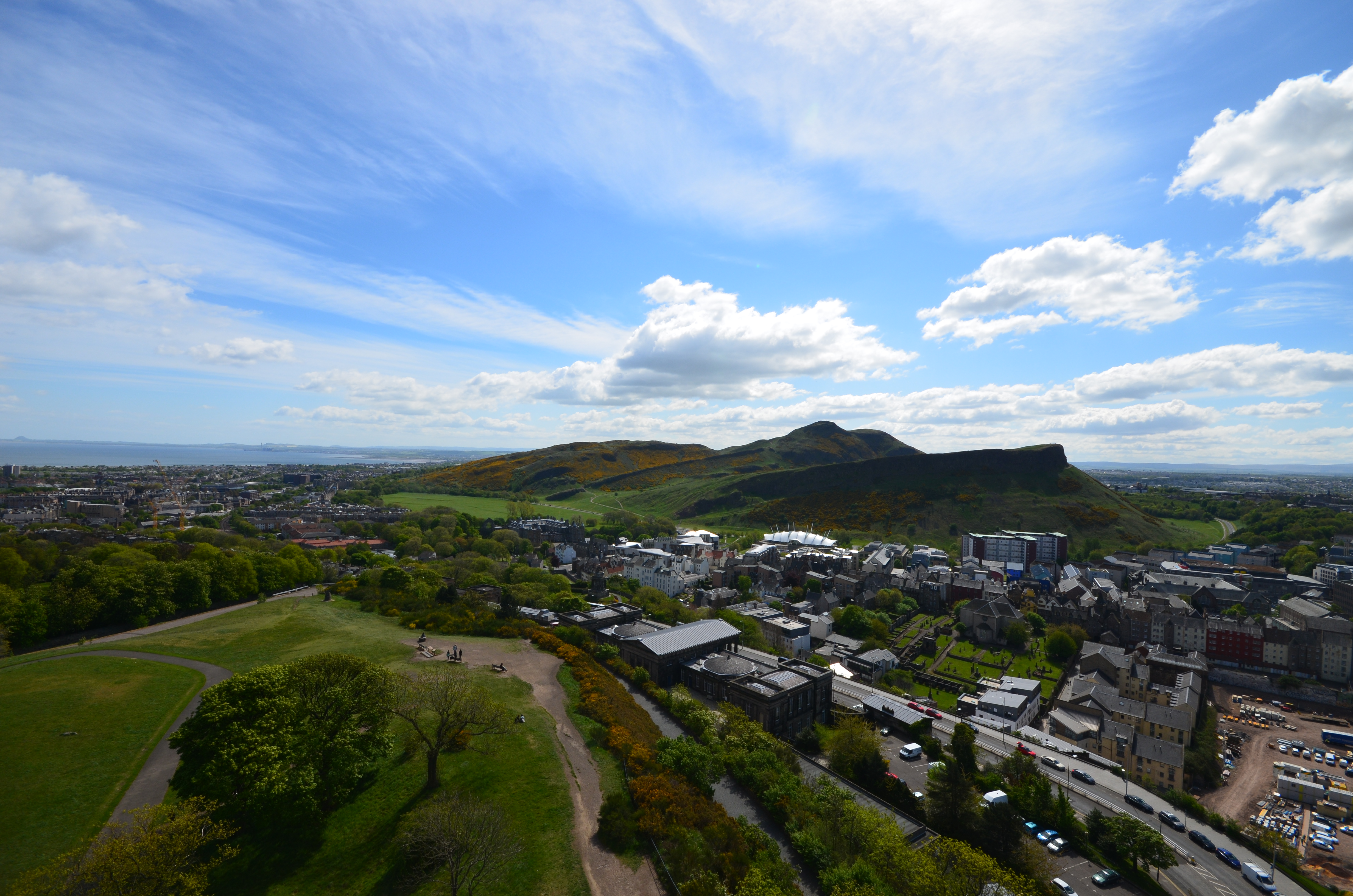
Arthur's Seat

Arthur's Seat (Scottish Gaelic: Suidhe Artair, pronounced [ˈs̪ɯi.əˈaɾt̪ʰəɾʲ]) is an ancient volcano which is the main peak of the group of hills in Edinburgh...
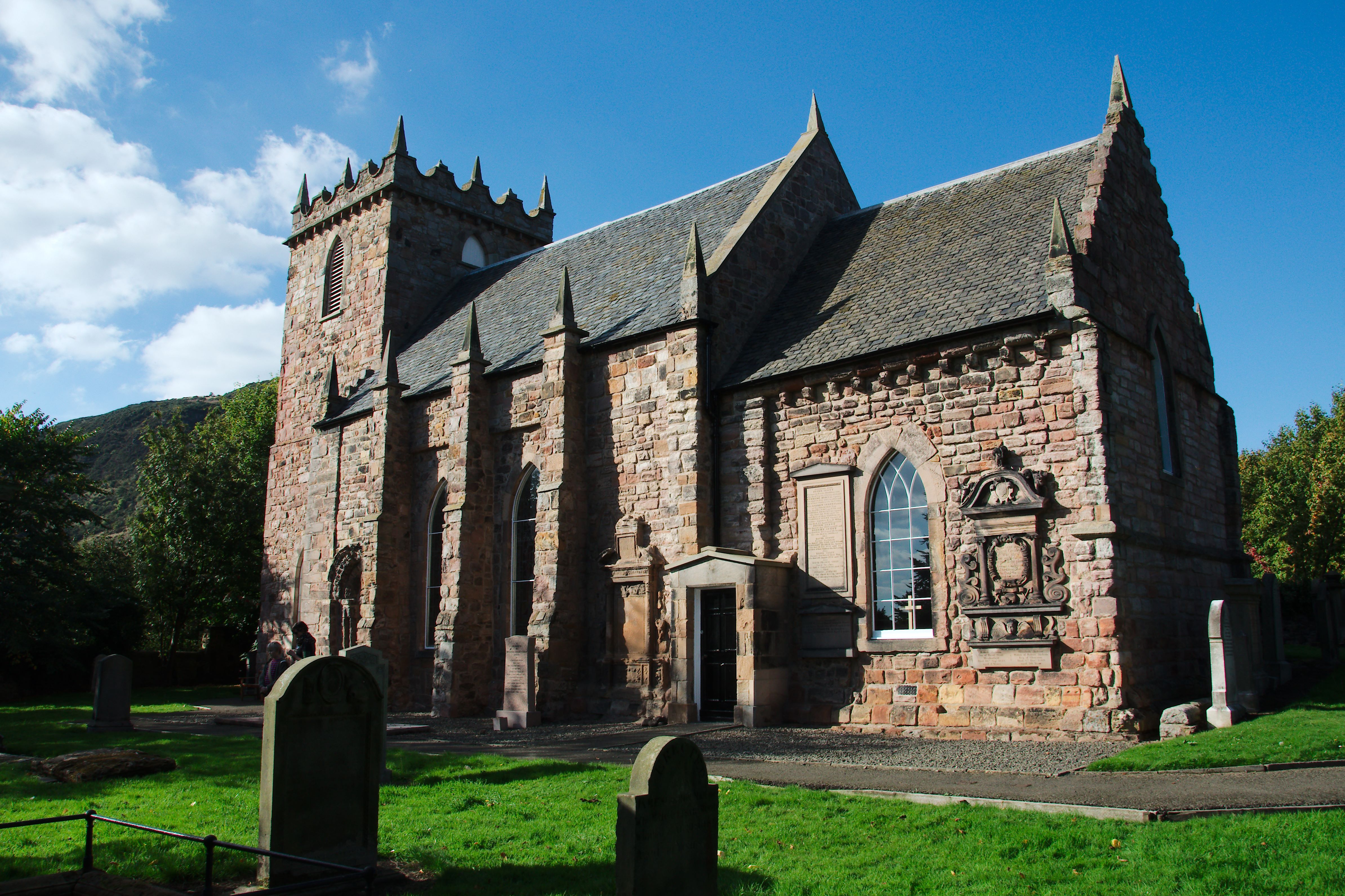
Duddingston Kirk

Duddingston Kirk is a Parish Church in the Church of Scotland, located adjacent to Holyrood Park in Duddingston Village, on the east side of the City of...

Nearby Amenities

Located within 500m of 55.946121,-3.1530805
Turning Circle
Lat/Long: 55.9497806/-3.1492674
Dunsapie Crag
Ele: 146
Natural: peak
Lat/Long: 55.9456422/-3.1511649
Whinny Hill
Ele: 178
Natural: peak
Wikidata: Q12955835
Lat/Long: 55.9480863/-3.1576318
Bench
Backrest: no
Check Date: 2021-01-03
Source: Bing;survey
Lat/Long: 55.9434192/-3.1521467
Bench
Backrest: no
Check Date: 2021-06-02
Lat/Long: 55.9457918/-3.1542034
Bench
Backrest: no
Check Date: 2021-04-25
Lat/Long: 55.9465927/-3.1540114
Bench
Backrest: no
Check Date: 2021-06-02
Lat/Long: 55.9470254/-3.1527259
Bench
Source: Bing;survey
Lat/Long: 55.9478246/-3.1503371
Bench
Backrest: no
Lat/Long: 55.948853/-3.1501917
Bench
Backrest: no
Lat/Long: 55.9496583/-3.1502664
Bench
Backrest: no
Lat/Long: 55.9500881/-3.1503929
Waste Basket
Check Date: 2021-01-03
Source: Bing;survey
Lat/Long: 55.9439733/-3.1524479
Waste Basket
Check Date: 2021-06-02
Lat/Long: 55.9448237/-3.1529181
Waste Basket
Check Date: 2021-06-02
Lat/Long: 55.9450073/-3.152902
Natural: stone
Source: Bing
Lat/Long: 55.9457647/-3.1501669
Waste Basket
Check Date: 2021-06-02
Source: Bing;survey
Lat/Long: 55.944616/-3.1525298
Barrier: small oak gate
Description: uilt and installed to mark the southernmost exit/entrance to the Field.
Lat/Long: 55.9428082/-3.1482939
Labyrinth
Description: A labyrinth marked by stones, wildflowers and grasses.
Leisure: garden
Website: http://duddingstonfield.weebly.com/labyrinth.html
Lat/Long: 55.9441027/-3.1486507
Bench
Bench 6
Designation: Measured Walk Bench 6
Source: local_knowledge
Lat/Long: 55.9430156/-3.149944
Bench
Bench 1
Backrest: no
Designation: Measured Walk Bench 1
Material: wood
Source: local_knowledge
Lat/Long: 55.9431294/-3.148215
Bench
Bench 5
Designation: Measured Walk Bench 5
Note: 'Feste Lente'
Source: local_knowledge
Lat/Long: 55.9433496/-3.1499648
Bench
Bench 2
Backrest: no
Designation: Measured Walk Bench 2
Material: wood
Source: local_knowledge
Lat/Long: 55.9434845/-3.148274
Bench
Bench 3
Backrest: no
Designation: Measured Walk Bench 3
Material: metal
Lat/Long: 55.9442758/-3.1483804
Bench
Bench 4
Backrest: no
Designation: Measured Walk Bench 4
Material: wood
Note: 'Rest and Be Thankful'
Source: local_knowledge
Lat/Long: 55.9447373/-3.1490083
Barrier: kissing_gate
Description: Built and installed to replace fence and provide northernmost entrance/exit point to the Field.
Lat/Long: 55.9450477/-3.1489941
cistern
Description: This old cistern is being repaired and will be used to harvest water that runs off the land to use for watering plants and for providing a fresh water supply for the chickens.
Water: cistern
Lat/Long: 55.942839/-3.1489537
Ele: 91.13
Ele Ft: 299
Man Made: survey_point
Source: NLS_OS_Edinburgh_map_1940s
Lat/Long: 55.9492837/-3.1494183
Addr City: Edinburgh
Addr Country: GB
Addr Housenumber: 54
Addr Street: Ulster Crescent
Source: survey
Lat/Long: 55.9494083/-3.1476173
Addr City: Edinburgh
Addr Country: GB
Addr Housenumber: 56
Addr Street: Ulster Crescent
Source: survey
Lat/Long: 55.9493924/-3.147775
Addr City: Edinburgh
Addr Country: GB
Addr Housenumber: 57
Addr Street: Ulster Crescent
Source: survey
Lat/Long: 55.9491886/-3.1472643
Addr City: Edinburgh
Addr Country: GB
Addr Housenumber: 58
Addr Street: Ulster Crescent
Source: survey
Lat/Long: 55.9493627/-3.1480061
Addr City: Edinburgh
Addr Country: GB
Addr Housenumber: 59
Addr Street: Ulster Crescent
Source: survey
Lat/Long: 55.9491718/-3.147478
Addr City: Edinburgh
Addr Country: GB
Addr Housenumber: 60
Addr Street: Ulster Crescent
Source: survey
Lat/Long: 55.9493228/-3.1481956
Addr City: Edinburgh
Addr Country: GB
Addr Housenumber: 61
Addr Street: Ulster Crescent
Source: survey
Lat/Long: 55.9491686/-3.1475721
Addr City: Edinburgh
Addr Country: GB
Addr Housenumber: 62
Addr Street: Ulster Crescent
Source: survey
Lat/Long: 55.9492628/-3.1484046
Addr City: Edinburgh
Addr Country: GB
Addr Housenumber: 63
Addr Street: Ulster Crescent
Source: survey
Lat/Long: 55.9491487/-3.147785
Addr City: Edinburgh
Addr Country: GB
Addr Housenumber: 64
Addr Street: Ulster Crescent
Source: survey
Lat/Long: 55.9491844/-3.1485744
Addr City: Edinburgh
Addr Country: GB
Addr Housenumber: 65
Addr Street: Ulster Crescent
Source: survey
Lat/Long: 55.9491429/-3.1479718
Addr City: Edinburgh
Addr Country: GB
Addr Housenumber: 66
Addr Street: Ulster Crescent
Source: survey
Lat/Long: 55.9490618/-3.1487461
Addr City: Edinburgh
Addr Country: GB
Addr Housenumber: 67
Addr Street: Ulster Crescent
Source: survey
Lat/Long: 55.9490931/-3.1481672
Addr City: Edinburgh
Addr Country: GB
Addr Housenumber: 71
Addr Street: Ulster Crescent
Source: survey
Lat/Long: 55.9489449/-3.1484382
Addr City: Edinburgh
Addr Country: GB
Addr Housenumber: 11
Addr Street: Paisley Terrace
Source: survey
Lat/Long: 55.9497151/-3.148462
Addr City: Edinburgh
Addr Country: GB
Addr Housenumber: 12
Addr Street: Paisley Terrace
Source: survey
Lat/Long: 55.9498914/-3.1489144
Addr City: Edinburgh
Addr Country: GB
Addr Housenumber: 13
Addr Street: Paisley Terrace
Source: survey
Lat/Long: 55.9496555/-3.1486355
Addr City: Edinburgh
Addr Country: GB
Addr Housenumber: 15
Addr Street: Paisley Terrace
Source: survey
Lat/Long: 55.9495975/-3.1488157
Addr City: Edinburgh
Addr Country: GB
Addr Housenumber: 17
Addr Street: Paisley Terrace
Source: survey
Lat/Long: 55.9496842/-3.1490215
Addr City: Edinburgh
Addr Country: GB
Addr Housenumber: 19
Addr Street: Paisley Terrace
Source: survey
Lat/Long: 55.9496294/-3.1492174
Addr City: Edinburgh
Addr Country: GB
Addr Housenumber: 21
Addr Street: Paisley Terrace
Source: survey
Lat/Long: 55.9495827/-3.1493852
Addr City: Edinburgh
Addr Country: GB
Addr Housenumber: 23
Addr Street: Paisley Terrace
Source: survey
Lat/Long: 55.9494653/-3.1495363
Addr City: Edinburgh
Addr Country: GB
Addr Housenumber: 25
Addr Street: Paisley Terrace
Source: survey
Lat/Long: 55.9495554/-3.1495851
Addr City: Edinburgh
Addr Country: GB
Addr Housenumber: 27
Addr Street: Paisley Terrace
Source: survey
Lat/Long: 55.949652/-3.1495976
Addr City: Edinburgh
Addr Country: GB
Addr Housenumber: 29
Addr Street: Paisley Terrace
Source: survey
Lat/Long: 55.9497463/-3.1496485
Addr City: Edinburgh
Addr Country: GB
Addr Housenumber: 31
Addr Street: Paisley Terrace
Source: survey
Lat/Long: 55.9498333/-3.149694
Addr City: Edinburgh
Addr Country: GB
Addr Housenumber: 35
Addr Street: Paisley Terrace
Source: survey
Lat/Long: 55.9499639/-3.1496196
Addr City: Edinburgh
Addr Country: GB
Addr Housenumber: 37
Addr Street: Paisley Terrace
Source: survey
Lat/Long: 55.9499741/-3.1495117
Addr City: Edinburgh
Addr Country: GB
Addr Housenumber: 41
Addr Street: Paisley Terrace
Source: survey
Lat/Long: 55.9499819/-3.1491837
Addr City: Edinburgh
Addr Country: GB
Addr Housenumber: 9
Addr Street: Paisley Terrace
Source: survey
Lat/Long: 55.9497224/-3.1482714
Addr City: Edinburgh
Addr Country: GB
Addr Housenumber: 64
Addr Street: The Causeway
Source: survey
Lat/Long: 55.9424455/-3.1494098
Addr City: Edinburgh
Addr Country: GB
Addr Housenumber: 69
Addr Street: Ulster Crescent
Source: survey
Lat/Long: 55.9490455/-3.1482743
Addr City: Edinburgh
Addr Country: GB
Addr Housenumber: 33
Addr Street: Paisley Terrace
Source: survey
Lat/Long: 55.9499203/-3.1498445
Addr City: Edinburgh
Addr Country: GB
Addr Housenumber: 39
Addr Street: Paisley Terrace
Source: survey
Lat/Long: 55.9500299/-3.1493184
Addr City: Edinburgh
Addr Country: GB
Addr Housenumber: 64/1
Addr Postcode: EH15 3PZ
Addr Street: The Causeway
Addr Suburb: Duddingston Village
Source: survey
Lat/Long: 55.9423787/-3.1488527
Barrier: stile
Stile: stepover
Lat/Long: 55.9441247/-3.1480762
Playground: climbingframe
Source: Bing;survey
Lat/Long: 55.9473402/-3.1467087
Luma 3D interactive Ltd
Addr City: Edinburgh
Addr Housenumber: 64/1
Addr Postcode: EH15 3PZ
Addr Street: The Causeway
Addr Suburb: Duddingston Village
Office: company
Phone: +44 131 661 7343
Source: survey
Website: https://www.lumainteractive.com/
Lat/Long: 55.942373/-3.1487647
The Style
Barrier: stile
Foot: yes
Horse: no
Material: stone
Motor Vehicle: no
Stile: wall
Lat/Long: 55.9458412/-3.1491009
Barrier: kerb
Lat/Long: 55.9489682/-3.1497395
Meadowfield Park
Information: map
Map Size: site
Tourism: information
Lat/Long: 55.9488229/-3.1488758
Information: map
Tourism: information
Lat/Long: 55.9449166/-3.1531001
Information: map
Tourism: information
Lat/Long: 55.9448742/-3.1529398
Bench
Backrest: no
Material: concrete
Lat/Long: 55.9426234/-3.1535429
Waste Basket
Source: Bing;survey
Lat/Long: 55.9426497/-3.1534822
Waste Basket
Source: Bing;survey
Lat/Long: 55.9433189/-3.1522248
Waste Basket
Lat/Long: 55.9481419/-3.1502816
Waste Basket
Lat/Long: 55.9489351/-3.1502804
Waste Basket
Lat/Long: 55.9469653/-3.1530313
Waste Basket
Lat/Long: 55.9485666/-3.1502562
Waste Basket
Lat/Long: 55.9493132/-3.150313
Bicycle Parking
Dunsapie Loch
Bicycle Parking: stands
Capacity: 6
Covered: no
Lat/Long: 55.9449363/-3.1530854
Parking
Dunsapie Loch
Lat/Long: 55.9447732/-3.1527554
The Accessible Pinnacle
Natural: rock
Lat/Long: 55.94608/-3.1522236
Bench: yes
Leisure: picnic_table
Lit: no
Material: wood
Lat/Long: 55.9424765/-3.1484888
Bench: yes
Leisure: picnic_table
Lit: no
Material: wood
Lat/Long: 55.9425037/-3.1484028
Bench: yes
Leisure: picnic_table
Lit: no
Material: wood
Lat/Long: 55.9425407/-3.1485219
Bench: yes
Leisure: picnic_table
Lit: no
Material: wood
Lat/Long: 55.9428527/-3.1481453
Bench
Backrest: yes
Material: wood
Lat/Long: 55.9426767/-3.1479116
Dunsapie
Historic: archaeological_site
Lat/Long: 55.9461957/-3.1517281
Hike to Arthurs Seat
Tourism: viewpoint
Lat/Long: 55.9446331/-3.1592846
The data included in this document is from www.openstreetmap.org. The data is made available under ODbL.

Have you been to Dunsapie Loch?

Leave your review of Dunsapie Loch below (or comments, questions and feedback).