Dock Tarn

Lake, Pool, Pond, Freshwater Marsh in Cumberland Allerdale

England

Dock Tarn

Watendlath, 1987 From across the tarn.
Watendlath, 1987 Credit: Nigel Thompson

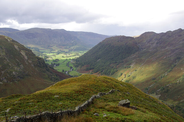
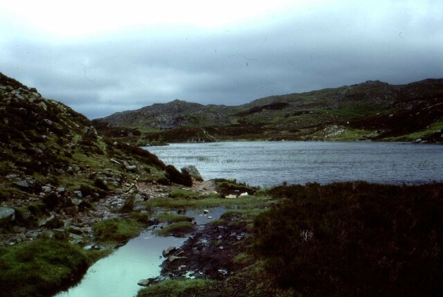
Dock Tarn, located in Cumberland, is a picturesque freshwater pond nestled within the heart of the Lake District National Park in northwest England. This serene body of water is classified as a tarn, which is a small mountain lake formed by glacial activity. Dock Tarn is situated at an elevation of approximately 1,640 feet (500 meters) above sea level, surrounded by lush greenery and craggy fells.

Covering an area of about 1.5 acres, the tarn boasts crystal-clear waters that reflect the stunning scenery around it. It is fed by a combination of rainfall and small streams, resulting in a constant flow of fresh water. The pond is relatively shallow, with a maximum depth of around 10 feet (3 meters), and features a gradual slope towards its center.

Dock Tarn is renowned for its rich biodiversity, serving as a habitat for various aquatic plants and animals. The margins of the tarn are adorned with vibrant rushes, sedges, and reeds, attracting a plethora of bird species, including ducks, grebes, and herons. Additionally, the pond is known to harbor a healthy population of brown trout, making it a popular spot among anglers.

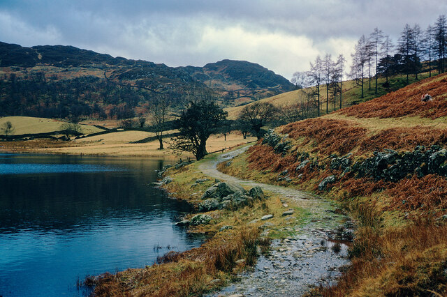
Visitors to Dock Tarn can enjoy the tranquility of the surrounding landscape while taking in the breathtaking views. The tarn is accessible via a scenic hiking trail, providing an opportunity for nature enthusiasts to explore the beauty of the Lake District. Whether it be for a leisurely stroll, birdwatching, or fishing, Dock Tarn offers a serene escape into nature's embrace.

If you have any feedback on the listing, please let us know in the comments section below.

Dock Tarn Images

Images are sourced within 2km of 54.519209/-3.1234037 or Grid Reference NY2714. Thanks to Geograph Open Source API. All images are credited.

Watendlath, 1987 From across the tarn.
Watendlath, 1987
From across the tarn.
Stonethwaite Beck In spate, downstream of the confluence of Langstrath Beck and Greenup Gill. Eagle Crag is in the background.
Stonethwaite Beck
In spate, downstream of the confluence of Langstrath Beck and Greenup Gill. Eagle Crag is in the background.
Bleak How Looking down Borrowdale from the shoulder below Eagle and Heron Crags.
Bleak How
Looking down Borrowdale from the shoulder below Eagle and Heron Crags.
Dock Tarn
Dock Tarn
Watendlath
Watendlath
Chapel House Farm, Borrowdale
Outflow from Watendlath Tarn, above Borrowdale Clear sky, ancient footbridge and the beauty of the Lake District combined
Outflow from Watendlath Tarn, above Borrowdale
Clear sky, ancient footbridge and the beauty of the Lake District combined
Watendlath Tarn With the famous white ducks.
Watendlath Tarn
With the famous white ducks.
Brightly lit rocks of knoll The knoll is one of the features of the higher part of Great Crag above Rosthwaite, in Borrowdale.
Dale Head is the conical peak at the centre of the horizon.
Brightly lit rocks of knoll
The knoll is one of the features of the higher part of Great Crag above Rosthwaite, in Borrowdale. Dale Head is the conical peak at the centre of the horizon.
Sheep movement in Borrowdale Traffic and pedestrians were asked politely to pause for a while as a large flock of sheep was moved from one field to another.
Sheep movement in Borrowdale
Traffic and pedestrians were asked politely to pause for a while as a large flock of sheep was moved from one field to another.
Route of Cumbria Way near to Stonethwaite Stonethwaite is a small settlement on the west side of Stonethwaite Beck; it's bypassed by the Cumbria Way which is on the other side of the stream.
Route of Cumbria Way near to Stonethwaite
Stonethwaite is a small settlement on the west side of Stonethwaite Beck; it's bypassed by the Cumbria Way which is on the other side of the stream.
Signs at Stonethwaite Bridge Choice of three bridleways on the Cumbria Way at Stonethwaite.
Signs at Stonethwaite Bridge
Choice of three bridleways on the Cumbria Way at Stonethwaite.
Private road sign Beside The Cumbria Way long distance path this large and unsightly notice is at the end of the minor road opposite the Royal Oak Hotel.
The green huts in the background are portable toilets.
Private road sign
Beside The Cumbria Way long distance path this large and unsightly notice is at the end of the minor road opposite the Royal Oak Hotel. The green huts in the background are portable toilets.
Evening sunlight on Eagle Crag The path through the gate can be used as an alternative to The Cumbria Way long distance trail, which follows the valley on the opposite side of Stonethwaite Beck.
Evening sunlight on Eagle Crag
The path through the gate can be used as an alternative to The Cumbria Way long distance trail, which follows the valley on the opposite side of Stonethwaite Beck.
View to Rosthwaite from the path to Watendlath A fine view including the prominent white building in Rosthwaite, the Guest House in which we were staying
View to Rosthwaite from the path to Watendlath
A fine view including the prominent white building in Rosthwaite, the Guest House in which we were staying
Approaching Watendlath on the path from Borrowdale A small hamlet that is most enjoyably approached on foot from Rosthwaite.
Approaching Watendlath on the path from Borrowdale
A small hamlet that is most enjoyably approached on foot from Rosthwaite.
Rosthwaite and Borrowdale from the path to Watendlath A fine view at any season of the year. See <a href="https://www.geograph.org.uk/photo/7352979">NY2615 : View to Rosthwaite from the path to Watendlath</a> for an Easter view.
Rosthwaite and Borrowdale from the path to Watendlath
A fine view at any season of the year. See NY2615 : View to Rosthwaite from the path to Watendlath for an Easter view.
Path by Watendlath Tarn A good destination for a walk from Rosthwaite in Borrowdale.
Path by Watendlath Tarn
A good destination for a walk from Rosthwaite in Borrowdale.
Show me another place!

Dock Tarn is located at Grid Ref: NY2714 (Lat: 54.519209, Lng: -3.1234037)

Administrative County: Cumbria

District: Allerdale

Police Authority: Cumbria

What 3 Words

///remember.shunning.enter. Near Keswick, Cumbria

Related Wikis

Dock Tarn

Dock Tarn is a small tarn located within the Lake District National Park in Cumbria, England, at grid reference NY273143. It is situated on moorland at...

Great Crag

Great Crag is a fell in the English Lake District, located near the hamlets of Rosthwaite and Stonethwaite in Borrowdale. == Topography == The higher slopes...

Rosthwaite, Borrowdale

Rosthwaite is a settlement in the Borrowdale parish of Cumberland, Cumbria, England. It is also in Borrowdale in the English Lake District to the south...

Borrowdale

Borrowdale is a valley and civil parish in the English Lake District in Cumberland, England. It is in the ceremonial county of Cumbria, and is sometimes...

Nearby Amenities

Located within 500m of 54.519209,-3.1234037
Source: npe
Lat/Long: 54.5201783/-3.1235504
Source: npe
Lat/Long: 54.5198506/-3.122613
Source: npe
Lat/Long: 54.5192914/-3.1227085
Source: npe
Lat/Long: 54.5185093/-3.1224347
Source: npe
Lat/Long: 54.5181615/-3.1233736
Source: npe
Lat/Long: 54.5188349/-3.1237486
Source: npe
Lat/Long: 54.5191509/-3.123978
Source: npe
Lat/Long: 54.5193963/-3.1245044
Source: npe
Lat/Long: 54.5198268/-3.1240979
Source: npe
Lat/Long: 54.5186024/-3.1237052
Source: npe
Lat/Long: 54.520085/-3.1245282
Ford: yes
Lat/Long: 54.5163841/-3.1264209
Waterway: waterfall
Lat/Long: 54.5159022/-3.127778
Barrier: stile
Height: 0.38
Source: survey
Width: 0.94
Lat/Long: 54.5163899/-3.127896
Waterway: waterfall
Lat/Long: 54.5157141/-3.1281397
Waterway: waterfall
Lat/Long: 54.5157939/-3.127988
Green Combe
Place: locality
Lat/Long: 54.5176584/-3.1210807
The data included in this document is from www.openstreetmap.org. The data is made available under ODbL.

Have you been to Dock Tarn?

Leave your review of Dock Tarn below (or comments, questions and feedback).