Comlifoot Pool

Lake, Pool, Pond, Freshwater Marsh in Caithness

Scotland

Comlifoot Pool

Passing Sibsterburn
Passing Sibsterburn Credit: Peter Moore

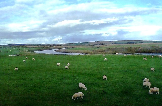
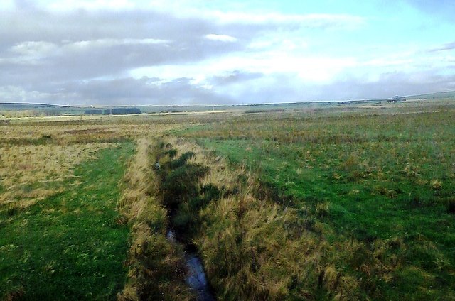
Comlifoot Pool, located in Caithness, Scotland, is a picturesque freshwater marshland that serves as a vital habitat for various plant and animal species. Spanning an area of approximately 10 acres, this natural pool is a significant feature of the local landscape.

Comlifoot Pool is surrounded by diverse vegetation, including reeds, grasses, and water lilies. These plants provide essential shelter and nesting sites for numerous bird species, such as mallards, coots, and moorhens, creating a thriving ecosystem. The pool's tranquil waters also attract a variety of insects, amphibians, and small mammals.

The pool's water source primarily comes from rainfall and underground springs, ensuring a constant supply of freshwater. Additionally, the surrounding peatland and marshes help maintain the water levels, preventing excessive evaporation during dry spells.

The pool's location in Caithness, a region known for its rich biodiversity, adds to its ecological importance. It acts as a stopover point for migratory birds, providing them with a vital resting spot during their long journeys. Furthermore, the pool's proximity to the North Sea makes it an attractive breeding ground for coastal species.

Apart from its ecological significance, Comlifoot Pool also offers recreational opportunities for visitors. Nature enthusiasts can appreciate the diverse wildlife and serene surroundings while exploring the area on foot. Birdwatchers, in particular, can find great joy in observing the various species that frequent the pool.

In conclusion, Comlifoot Pool in Caithness is a remarkable freshwater marshland that supports a wide range of plant and animal life. Its ecological importance, combined with its scenic beauty, makes it a valuable asset to the local community and a haven for nature lovers.

If you have any feedback on the listing, please let us know in the comments section below.

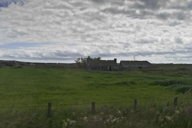
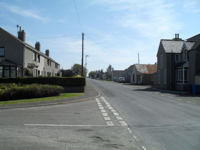
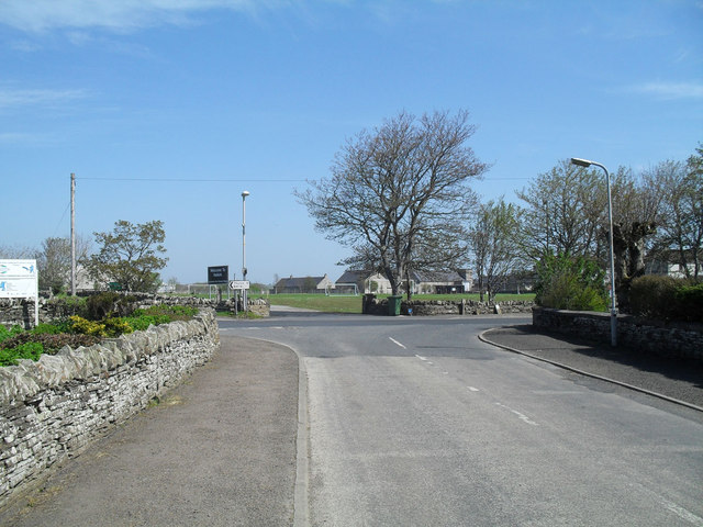
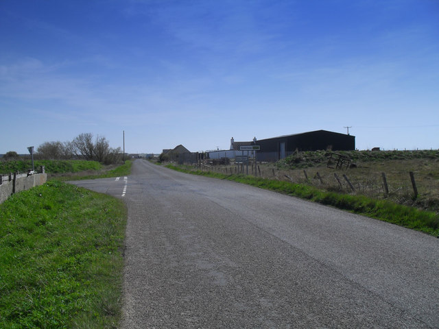
Comlifoot Pool Images

Images are sourced within 2km of 58.515812/-3.4922108 or Grid Reference ND1359. Thanks to Geograph Open Source API. All images are credited.

Passing Sibsterburn
Passing Sibsterburn
Main street in Halkirk In his book, Notes from a Small Island, Bill Bryson was rather less than full of praise for Halkirk. There's not much to it really....
Main street in Halkirk
In his book, Notes from a Small Island, Bill Bryson was rather less than full of praise for Halkirk. There's not much to it really....
Junction in Halkirk
Junction in Halkirk
Gentle climb out of Halkirk
Rifle Range and Site of Former Drill Hall Halkirk Rifle Range and the site of the former Drill Hall (now demolished). The Rifle Range is still used by the Army Cadet Corps.
Rifle Range and Site of Former Drill Hall
Halkirk Rifle Range and the site of the former Drill Hall (now demolished). The Rifle Range is still used by the Army Cadet Corps.
Site of Former Drill Hall The two adjoined cottages are believed to be the only part of Halkirk Drill Hall to have survived the demolition of the building.
Site of Former Drill Hall
The two adjoined cottages are believed to be the only part of Halkirk Drill Hall to have survived the demolition of the building.
Grazing Land Near Halkirk Viewed from a passing train in late October. The River Thurso is shown in the background.
Grazing Land Near Halkirk
Viewed from a passing train in late October. The River Thurso is shown in the background.
Sibster Land Drainage ditches on the farmland at Sibster, near Georgemas Junction on the northern railway line.
Sibster Land
Drainage ditches on the farmland at Sibster, near Georgemas Junction on the northern railway line.
Halkirk Halt railway station (site), Highland Opened in 1874 on the Highland Railway's line from Dingwall to Wick, this station closed in 1960.
View north east towards Georgemas Junction and Wick. The former platform, signal box and single-storey building were to the left of the line.
Halkirk Halt railway station (site), Highland
Opened in 1874 on the Highland Railway's line from Dingwall to Wick, this station closed in 1960. View north east towards Georgemas Junction and Wick. The former platform, signal box and single-storey building were to the left of the line.
The Ross Institute and the Parish church, Halkirk
The River Thurso in Halkirk Looking downstream.
The River Thurso in Halkirk
Looking downstream.
Farmland near Halkirk Through the window from a train heading to Thurso.
Farmland near Halkirk
Through the window from a train heading to Thurso.
Halkirk Free Presbyterian church tower
River Thurso viewed from Halkirk Bridge Looking north-westward.
River Thurso viewed from Halkirk Bridge
Looking north-westward.
Bridge Street, Halkirk Looking south-eastward.
Bridge Street, Halkirk
Looking south-eastward.
Memorial, Halkirk Cemetery In the older part of the cemetery.
Memorial, Halkirk Cemetery
In the older part of the cemetery.
Ordnance Survey Flush Bracket S7852 This bracket can be found on the wall of Halkirk Church.
The recorded details give a height of 40.9785 metres above sea level.
For more detail see : <span class="nowrap"><a title="https://www.bench-marks.org.uk/bm21119" rel="nofollow ugc noopener" href="https://www.bench-marks.org.uk/bm21119">Link</a><img style="margin-left:2px;" alt="External link" title="External link - shift click to open in new window" src="https://s1.geograph.org.uk/img/external.png" width="10" height="10"/></span>
Ordnance Survey Flush Bracket S7852
This bracket can be found on the wall of Halkirk Church. The recorded details give a height of 40.9785 metres above sea level. For more detail see : LinkExternal link
Sinclair Street, Halkirk Sinclair Street in the small town of Halkirk in the far north of Scotland.  This road forms part of the route of the B874 road.
Sinclair Street, Halkirk
Sinclair Street in the small town of Halkirk in the far north of Scotland. This road forms part of the route of the B874 road.
Show me another place!

Comlifoot Pool is located at Grid Ref: ND1359 (Lat: 58.515812, Lng: -3.4922108)

Unitary Authority: Highland

Police Authority: Highlands and Islands

What 3 Words

///director.damage.shorthand. Near Halkirk, Highland

Related Wikis

Halkirk Auld Kirk

Halkirk Auld Kirk is a former parish church in Halkirk, Caithness, Scotland. Built in 1753, it stopped being used in 1934 and is now a ruin. Halkirk parish...

Halkirk United F.C.

Halkirk United Football Club are a senior football team from Halkirk, Caithness in Scotland, who compete in the North Caledonian Football League. ��2...

Halkirk

Halkirk (Scottish Gaelic: Hàcraig) is a village on the River Thurso in Caithness, in the Highland council area of Scotland. From Halkirk the B874 road...

Braal Castle

Braal Castle is located by the River Thurso north of the village of Halkirk, in Caithness, northern Scotland. The ruined castle, which dates back to the...

Nearby Amenities

Located within 500m of 58.515812,-3.4922108
Turning Circle
Lat/Long: 58.5172402/-3.4934473
Bus Stop
Lat/Long: 58.51594/-3.4957238
Fast Food
Taj Mahal
Lat/Long: 58.5139782/-3.495646
Commercial Hotel
Tourism: hotel
Lat/Long: 58.5138138/-3.4955052
Post Office
Halkirk Post Office
Addr City: Halkirk
Addr Country: GB
Addr Postcode: KW12 6XN
Addr Street: Crescent Street
Opening Hours: Mo-Th 09:00-13:00,14:00-17:00; Fr 09:00-13:00; Sa 09:00-12:30
Ref Pol Id: 7592
Source: OS_OpenData_StreetView
Lat/Long: 58.5151039/-3.4934087
Morrisons Daily
Brand: Morrisons Daily
Brand Wikidata: Q99752411
Shop: convenience
Website: https://my.morrisons.com/storefinder/61522/morrisons-daily-halkirk-sinclair-street
Lat/Long: 58.5140032/-3.4951503
Bus Stop
Sinclair street
Naptan AtcoCode: 6700600162
Naptan Bearing: SW
Naptan CommonName: Sinclair street
Naptan Indicator: opp Mace Store
Naptan Landmark: Mace Shop
Naptan NaptanCode: 45325943
Naptan Street: Sinclair Street
Naptan Verified: no
Source: naptan_import
Lat/Long: 58.5138899/-3.4943252
Bus Stop
Sinclair Street
Naptan AtcoCode: 6700600163
Naptan Bearing: W
Naptan CommonName: Sinclair Street
Naptan Indicator: Southbound by Sinclair Square
Naptan Landmark: Sinclair Square
Naptan NaptanCode: 45325945
Naptan Street: Sinclair Street
Naptan Verified: no
Source: naptan_import
Lat/Long: 58.5145689/-3.4900107
Bus Stop
Sinclair Street
Naptan AtcoCode: 6700600164
Naptan Bearing: E
Naptan CommonName: Sinclair Street
Naptan Indicator: Northbound prior to Sinclair Square
Naptan Landmark: Sinclair Square
Naptan NaptanCode: 45325946
Naptan Street: Sinclair Street
Naptan Verified: no
Source: naptan_import
Lat/Long: 58.5144007/-3.4897975
Bus Stop
Primary School
Naptan AtcoCode: 6700712755
Naptan Bearing: S
Naptan CommonName: Primary School
Naptan Indicator: Bus Stop at Braal Terrace
Naptan Landmark: Braal Terrace
Naptan NaptanCode: 45325976
Naptan Street: Bridge Street
Naptan Verified: no
Source: naptan_import
Lat/Long: 58.5161866/-3.4953499
Bus Stop
Sinclair Street
Naptan AtcoCode: 6700712756
Naptan Bearing: NE
Naptan CommonName: Sinclair Street
Naptan Indicator: o/s Mace Shop
Naptan Landmark: Mace Shop
Naptan NaptanCode: 45325942
Naptan Street: Sinclair Street
Naptan Verified: no
Source: naptan_import
Lat/Long: 58.5140773/-3.4944361
Halkirk
Name En: Halkirk
Name Gd: Hàcraig
Name Sco: Hakrig
Place: village
Population: 940
Wikidata: Q1011584
Wikipedia: en:Halkirk
Lat/Long: 58.5139019/-3.4952819
Police
Source: OS_OpenData_StreetView
Lat/Long: 58.516629/-3.4951765
J & G Sutherland
Shop: car
Lat/Long: 58.5147311/-3.4928939
Telephone
Booth: K6
Covered: booth
Operator: BT
Lat/Long: 58.5150038/-3.4932121
Post Box
Post Box Design: ludlow
Post Box Type: wall
Royal Cypher: GVIR
Royal Cypher Wikidata: Q33102169
Lat/Long: 58.5150783/-3.4933665
Turning Circle
Lat/Long: 58.5171182/-3.4945402
Toilets
Lat/Long: 58.5155578/-3.4954172
Sengas B&B
Tourism: guest_house
Lat/Long: 58.5161937/-3.4946394
Doctors
Lat/Long: 58.5162372/-3.494854
Bench
Lat/Long: 58.5150226/-3.4930878
Traffic Calming: choker
Lat/Long: 58.5149652/-3.4938254
Power: pole
Lat/Long: 58.5169232/-3.500459
Power: pole
Lat/Long: 58.5170685/-3.4993362
Power: pole
Lat/Long: 58.5172636/-3.4976692
Power: pole
Lat/Long: 58.518097/-3.4980631
Bench
Lat/Long: 58.5164424/-3.4851162
The data included in this document is from www.openstreetmap.org. The data is made available under ODbL.

Have you been to Comlifoot Pool?

Leave your review of Comlifoot Pool below (or comments, questions and feedback).