Baddinsgill Reservoir

Lake, Pool, Pond, Freshwater Marsh in Peeblesshire

Scotland

Baddinsgill Reservoir

Lamb Rig Newly planted with trees.
Lamb Rig Credit: Richard Webb

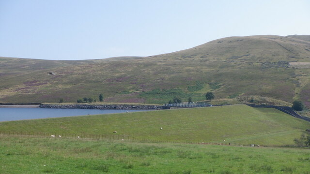
Baddinsgill Reservoir, located in Peeblesshire, Scotland, is a picturesque freshwater lake nestled in the scenic Pentland Hills. With its tranquil surroundings and natural beauty, it serves as a popular recreational spot for locals and tourists alike.

Spanning an area of approximately 40 hectares, Baddinsgill Reservoir boasts crystal-clear waters that are teeming with diverse aquatic life. The lake is primarily fed by rainfall and runoff from the surrounding hills, ensuring a constant supply of fresh water. The reservoir's depth varies throughout the year, depending on the precipitation levels and water management practices.

Surrounded by rolling hills and lush greenery, the reservoir offers a stunning backdrop for outdoor activities such as fishing, boating, and birdwatching. Anglers are drawn to Baddinsgill Reservoir for its abundant stocks of brown trout, which thrive in its cool, nutrient-rich waters. The calm and peaceful atmosphere makes it an ideal spot for a leisurely boat ride or a quiet picnic by the water's edge.

In addition to its recreational value, Baddinsgill Reservoir plays a vital role in supplying water to nearby communities. It is managed by the local water authority, which ensures that the reservoir remains a sustainable source of fresh water for both human consumption and irrigation purposes.

Overall, Baddinsgill Reservoir offers a serene escape from the hustle and bustle of city life, providing visitors with a chance to immerse themselves in nature's beauty and enjoy a range of outdoor activities in a truly idyllic setting.

If you have any feedback on the listing, please let us know in the comments section below.

Baddinsgill Reservoir Images

Images are sourced within 2km of 55.786454/-3.3912323 or Grid Reference NT1255. Thanks to Geograph Open Source API. All images are credited.

Lamb Rig Newly planted with trees.
Lamb Rig
Newly planted with trees.
Sawmill, Baddinsgill
The dam, Baddinsgill Reservoir
Log stacks, Thieves Road
Pentland Hills near Baddinsgill Reservoir A field almost surrounded by a shelter belt.
Pentland Hills near Baddinsgill Reservoir
A field almost surrounded by a shelter belt.
Thieves Road The track that crosses the pass at Cauldstane Slap with East Cairn Hill in the background.
Thieves Road
The track that crosses the pass at Cauldstane Slap with East Cairn Hill in the background.
Quarry on Muckle Knock A rather uncomfortable stony road runs to the quarry. After the quarry there is a lovely grassy track into the moors below West Cairn Hill.
Quarry on Muckle Knock
A rather uncomfortable stony road runs to the quarry. After the quarry there is a lovely grassy track into the moors below West Cairn Hill.
Byrehope Mount Pentland Hills.  Byrehope is the hollow just beneath the summit.
Byrehope Mount
Pentland Hills. Byrehope is the hollow just beneath the summit.
The Baddinsgill Burn, Pentland Hills 2009 view here: <a href="https://www.geograph.org.uk/photo/1209261">NT1155 : Valley of the Baddinsgill Burn</a>
The Baddinsgill Burn, Pentland Hills
Track on Muckle Knock A very enjoyable grassy track - it leads nowhere. The early part is horribly stony but pass the quarry and you are rewarded.
Track on Muckle Knock
A very enjoyable grassy track - it leads nowhere. The early part is horribly stony but pass the quarry and you are rewarded.
Summit, Muckle Knock I am still finding the odd Pentland summit that I have not visited. Good view through to The Kips.
Summit, Muckle Knock
I am still finding the odd Pentland summit that I have not visited. Good view through to The Kips.
Gathering ground of the Baddinsgill Burn The ruin is absent from the 1897 survey but appears on mid 20th century maps. It is surrounded by a small area of improved grassland.
Gathering ground of the Baddinsgill Burn
The ruin is absent from the 1897 survey but appears on mid 20th century maps. It is surrounded by a small area of improved grassland.
Ruin, Baddinsgill Burn The ruin is absent from the 1897 survey but appears on mid 20th century maps. It is surrounded by a small area of improved grassland
Ruin, Baddinsgill Burn
The ruin is absent from the 1897 survey but appears on mid 20th century maps. It is surrounded by a small area of improved grassland
Log pile with buried roadsign Baddinsgill, Pentland Hills.
Log pile with buried roadsign
Baddinsgill, Pentland Hills.
Heather moorland near the Ravendean Burn Viewed from the Thieves' Road, the old drove road that crosses this tract of moorland.
Heather moorland near the Ravendean Burn
Viewed from the Thieves' Road, the old drove road that crosses this tract of moorland.
Sheep grazing near Baddinsgill Farm The smoke is coming from a chimney at a timber and firewood business that operates from this site.
Sheep grazing near Baddinsgill Farm
The smoke is coming from a chimney at a timber and firewood business that operates from this site.
The Pentland Hills From Portmore Estate
The Pentland Hills
From Portmore Estate
Baddinsgill Reservoir spillway
Show me another place!

Baddinsgill Reservoir is located at Grid Ref: NT1255 (Lat: 55.786454, Lng: -3.3912323)

Unitary Authority: The Scottish Borders

Police Authority: The Lothians and Scottish Borders

What 3 Words

///hogs.knowledge.reception. Near West Linton, Scottish Borders

Related Wikis

Baddinsgill Reservoir

Baddinsgill Reservoir is a small reservoir in the Scottish Borders area of Scotland close to Carlops, West Linton, and the boundary with Midlothian. It...

Baddinsgill

Baddinsgill is a hamlet in the Scottish Borders area of Scotland. The Baddinsgill Reservoir is a few hundred metres north of the hamlet. == See also... ==

Pentland Hills

The Pentland Hills are a range of hills southwest of Edinburgh, Scotland. The range is around twenty miles (thirty kilometres) in length, and runs southwest...

Carlops

Carlops (Scottish Gaelic: Leum na Caillich) is a small village in the Pentland Hills, within the Scottish Borders area of Scotland, close to the boundary...

Nearby Amenities

Located within 500m of 55.786454,-3.3912323
Waterway: weir
Lat/Long: 55.7840184/-3.389025
Power: pole
Lat/Long: 55.7828568/-3.3956649
Power: pole
Lat/Long: 55.783293/-3.3955892
Power: pole
Lat/Long: 55.783617/-3.3955409
The data included in this document is from www.openstreetmap.org. The data is made available under ODbL.

Have you been to Baddinsgill Reservoir?

Leave your review of Baddinsgill Reservoir below (or comments, questions and feedback).