Loch Meadhoin

Lake, Pool, Pond, Freshwater Marsh in Caithness

Scotland

Loch Meadhoin

Ruined cottage
Ruined cottage Credit: Peter Moore

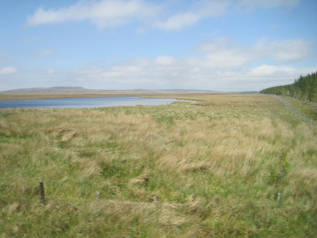
Loch Meadhoin is a picturesque freshwater loch located in the county of Caithness, Scotland. Nestled amidst stunning natural surroundings, this body of water holds great significance for both locals and visitors alike. The loch is situated in the northern part of Caithness, near the village of Mey.

Covering an area of approximately 50 acres, Loch Meadhoin is a relatively small yet enchanting water body. Its crystal-clear waters are fed by several small streams and springs, ensuring a constant flow of freshwater. Surrounded by rolling hills and lush greenery, the loch offers a tranquil and peaceful atmosphere to all who visit.

The shoreline of Loch Meadhoin is dotted with a variety of vegetation, including reeds, rushes, and water lilies. These provide an ideal habitat for numerous species of birds, insects, and small mammals that thrive in the area's freshwater marshes. Birdwatchers are particularly drawn to the loch due to the diverse range of bird species that can be spotted here, including ducks, swans, herons, and even ospreys.

The loch is also a popular spot for fishing enthusiasts, as it is known for its abundance of brown trout. Anglers can be seen casting their lines from the banks or from small boats, hoping to reel in a prized catch.

Overall, Loch Meadhoin is a captivating and serene natural feature that showcases the beauty of Scotland's Caithness region. Whether for birdwatching, fishing, or simply enjoying the tranquility of the surroundings, Loch Meadhoin offers a delightful experience for all who venture there.

If you have any feedback on the listing, please let us know in the comments section below.

Loch Meadhoin Images

Images are sourced within 2km of 58.443661/-3.609819 or Grid Reference ND0651. Thanks to Geograph Open Source API. All images are credited.

Ruined cottage
Ruined cottage
Loch Meadhoin before Scotscalder
End of the Woods
End of the Woods
Allt na h-Imriche This small burn is a tributary of the Torran Water.
Allt na h-Imriche
This small burn is a tributary of the Torran Water.
Moorland View Looking across the Flow Country from the Inverness-Thurso railway line on a fine late-October morning.
Moorland View
Looking across the Flow Country from the Inverness-Thurso railway line on a fine late-October morning.
Loch Meadhoin View Viewed from a train crossing the Flow Country on the way to Thurso.
Loch Meadhoin View
Viewed from a train crossing the Flow Country on the way to Thurso.
Forest Edge NearDorrerey A quick glimpse of the forest edge from a train on the way to Thurso, viewed in late October.
Forest Edge NearDorrerey
A quick glimpse of the forest edge from a train on the way to Thurso, viewed in late October.
View from a Helmsdale-Thurso train - Forest edge
View from a Helmsdale-Thurso train - Loch Meadhoin
View from a Helmsdale-Thurso train - ruined snowfence Built to stop snow drifting onto the railway line. Maybe the winters aren't so harsh these days?
View from a Helmsdale-Thurso train - ruined snowfence
Built to stop snow drifting onto the railway line. Maybe the winters aren't so harsh these days?
View from a Helmsdale-Thurso train - ruined cottage
Ca-na-Catanach Track The 19th century estate road to Loch Caluim overlies the much earlier route called Ca-na-Catanach. Viewed looking towards Ben Dorrery.
Ca-na-Catanach Track
The 19th century estate road to Loch Caluim overlies the much earlier route called Ca-na-Catanach. Viewed looking towards Ben Dorrery.
Cnoc-glas on the Ca-na-Catanach The ruined house of Cnoc-glas lies next to the Ca-na-Catanach, an ancient route from Caithness to Kinbrace in Sutherland.
Cnoc-glas on the Ca-na-Catanach
The ruined house of Cnoc-glas lies next to the Ca-na-Catanach, an ancient route from Caithness to Kinbrace in Sutherland.
Sheiling at Cnoc-glas The rectangular outline of a sheiling hut can be seen on this grassy mound.
Sheiling at Cnoc-glas
The rectangular outline of a sheiling hut can be seen on this grassy mound.
Forest Fence with Watergate Forest fences crossing watercourses require 'watergates' that exclude deer while  being able to withstand spates. Timber construction is normally used but here a watergate has been constructed of modern materials
Forest Fence with Watergate
Forest fences crossing watercourses require 'watergates' that exclude deer while being able to withstand spates. Timber construction is normally used but here a watergate has been constructed of modern materials
Blanket Bog Blanket Bog near Braehour Forest. No rock or mineral soil is visible in this landscape: the ground is covered by deep peat.
Blanket Bog
Blanket Bog near Braehour Forest. No rock or mineral soil is visible in this landscape: the ground is covered by deep peat.
Shieling, Braehour Forest Traces of a Shieling Hut, one of several at this location, can be seen on this knoll.
Shieling, Braehour Forest
Traces of a Shieling Hut, one of several at this location, can be seen on this knoll.
Shieling Site, Allt Loch a' Chairn There are the remains of several shieling huts at this location. The site is typical of many shielings: well-drained grassy knolls near to a burn.
Shieling Site, Allt Loch a' Chairn
There are the remains of several shieling huts at this location. The site is typical of many shielings: well-drained grassy knolls near to a burn.
Show me another place!

Loch Meadhoin is located at Grid Ref: ND0651 (Lat: 58.443661, Lng: -3.609819)

Unitary Authority: Highland

Police Authority: Highlands and Islands

What 3 Words

///expired.giraffes.lunging. Near Halkirk, Highland

Related Wikis

Ca na Catanach

Ca na Catanach (translation: "Sutherland Men's Path") is a road and footpath between Sutherland and Caithness through the moorland in the northeastern...

Dorrery

Dorrery is a small hamlet lying to the east of Ben Dorrery in the district of Halkirk in Caithness, Scottish Highlands and is in the Scottish council...

Loch Shurrery

Loch Shurrery (also known as Loch Shurrey) is a small, shallow, lowland freshwater loch lying approximately 8 mi (13 km) south west of Thurso in the Scottish...

Olgrinmore

Olgrinmore is a small area in Halkirk, Northern Scotland, south of Thurso and John o' Groats. The B870 runs directly through the centre with Scotscalder...

Scotscalder

Scots Calder is an area within Halkirk, Northern Scotland. It is served by Scotscalder railway station which is operated by ScotRail. The B870 runs directly...

Scotscalder railway station

Scotscalder railway station is a railway station located in the Highland council area in the far north of Scotland. It serves several rural hamlets in...

Westerdale, Highland

Westerdale (Scottish Gaelic: An Dail Shuas) is a scattered crofting village which lies on the River Thurso, located five miles (eight kilometres) directly...

Battle of Harpsdale

The Battle of Harpsdale (Battle of Achardale, Battle of Harpasdal) was a Scottish clan battle fought in 1426 at Achardale, about 8 miles (13 km) south...

Have you been to Loch Meadhoin?

Leave your review of Loch Meadhoin below (or comments, questions and feedback).