Oxhall Pool

Lake, Pool, Pond, Freshwater Marsh in Brecknockshire

Wales

Oxhall Pool

Old oak in full leaf  Farmland mainly for grazing here
Old oak in full leaf Credit: Eirian Evans

Oxhall Pool is a picturesque freshwater lake located in Brecknockshire, a historic county in Wales. Nestled amidst the lush green countryside, this tranquil body of water offers a serene escape for both locals and tourists alike.

Covering an area of approximately 10 acres, Oxhall Pool is surrounded by rolling hills and dense vegetation, creating a stunning natural landscape. The pool itself is fed by a small stream that flows from the nearby hills, ensuring a constant supply of fresh, clean water.

The water in Oxhall Pool is crystal clear, allowing visitors to observe the diverse range of aquatic life that calls this lake home. Various species of fish, including perch, trout, and pike, thrive in its depths, making it a popular spot for fishing enthusiasts.

Beyond the lake, Oxhall Pool is also surrounded by a vibrant freshwater marsh and pond ecosystem. This diverse habitat supports a multitude of plant and animal species, including water lilies, reeds, and dragonflies. The marshland provides a vital breeding ground for birds such as mallards, coots, and swans, making it a haven for birdwatchers.

Visitors to Oxhall Pool can enjoy a range of recreational activities. Fishing, boating, and nature walks are popular pastimes, allowing visitors to fully immerse themselves in the beauty of this natural gem. The peaceful atmosphere and stunning scenery make Oxhall Pool a perfect destination for those seeking a break from the hustle and bustle of everyday life.

If you have any feedback on the listing, please let us know in the comments section below.

Oxhall Pool Images

Images are sourced within 2km of 52.209685/-3.4488599 or Grid Reference SO0157. Thanks to Geograph Open Source API. All images are credited.

Old oak in full leaf  Farmland mainly for grazing here
Old oak in full leaf
Farmland mainly for grazing here
Overtaking lane on the A470 On the hill entering Newbridge-on-Wye from the north
Overtaking lane on the A470
On the hill entering Newbridge-on-Wye from the north
River Wye at Newbridge-on-Wye
Powys countryside The trees in the foreground follow the Hirnant River, a tributary of the Wye. Most of the county's farmland is used for rearing livestock so what we see is mostly grassland.
Powys countryside
The trees in the foreground follow the Hirnant River, a tributary of the Wye. Most of the county's farmland is used for rearing livestock so what we see is mostly grassland.
Cutting for A470 near Brookfield
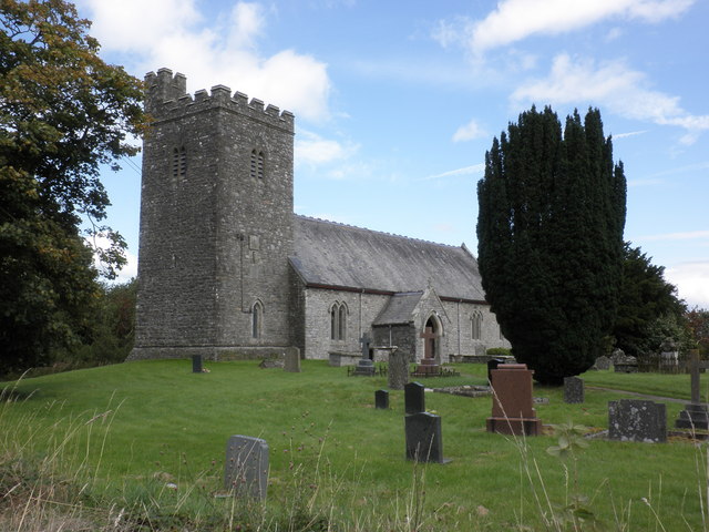
The church in Wyvern, Newbridge-on-Wye
Access road to Glan Gwy
Old Milestone by the A470, Newbridge on Wye, Llanyre Parish By the A470, in parish of Llanyre (Powys District), Newbridge-on-Wye, 30m North of New Inn on verge, East side of road.

Inscription reads:- 
TO / RHAYADER / 8 MILES / BUILTH / 5 

Milestone Society National ID: RAD_RYBU08.
Old Milestone by the A470, Newbridge on Wye, Llanyre Parish
By the A470, in parish of Llanyre (Powys District), Newbridge-on-Wye, 30m North of New Inn on verge, East side of road. Inscription reads:- TO / RHAYADER / 8 MILES / BUILTH / 5 Milestone Society National ID: RAD_RYBU08.
The Golden Lion, Newbridge-on-Wye
Bridleway south-west of Newbridge-on-Wye, Powys The bridleway leads to farms at Pen-y-rhiw and Pentre. The track allows access to many fields along the way.
Bridleway south-west of Newbridge-on-Wye, Powys
The bridleway leads to farms at Pen-y-rhiw and Pentre. The track allows access to many fields along the way.
Farmland  south-west of Newbridge, Powys Looking towards the summit at Ty Mawr, across the track shown in this image: <a title="https://www.geograph.org.uk/photo/2935101" href="https://www.geograph.org.uk/photo/2935101">Link</a> .
Farmland south-west of Newbridge, Powys
Looking towards the summit at Ty Mawr, across the track shown in this image: Link .
Narrow lane south-west of Newbridge, Powys The lane leads towards Builth Wells, and traverses the hillside above the west bank of the meandering River Wye.
Narrow lane south-west of Newbridge, Powys
The lane leads towards Builth Wells, and traverses the hillside above the west bank of the meandering River Wye.
Pasture south-west of Newbridge, Powys Looking across to the Wye Valley from the B4358 above Schache farm.
Pasture south-west of Newbridge, Powys
Looking across to the Wye Valley from the B4358 above Schache farm.
Pasture west of Newbridge-on-Wye, Powys A bridleway into the hills runs between the hedges and past the tree on the left.
Pasture west of Newbridge-on-Wye, Powys
A bridleway into the hills runs between the hedges and past the tree on the left.
Country west of Newbridge-on-Wye
The start of the bridleway to Pen-y-rhiw
The entrance to Gwern-llan-uchaf
Country south-west of Newbridge-on-Wye
Show me another place!

Oxhall Pool is located at Grid Ref: SO0157 (Lat: 52.209685, Lng: -3.4488599)

Unitary Authority: Powys

Police Authority: Dyfed Powys

What 3 Words

///putter.essays.moment. Near Llandrindod Wells, Powys

Related Wikis

Newbridge-on-Wye

Newbridge-on-Wye (Welsh: Y Bontnewydd-ar-Wy) is a small village in Powys, Wales. It lies, as its name suggests, on the River Wye, just downstream from...

Newbridge on Wye railway station

Newbridge on Wye railway station stood on the single-tracked Mid Wales Railway between Builth Wells and Rhayader. It was closed on 31 December 1962 and...

Llysdinam

Llysdinam is a hamlet located in Powys, Wales, to the west and near to the town of Llandrindod Wells. == History == The Llysdinam estate and hamlet were...

River Ithon

The River Ithon (Welsh: Afon Ieithon) is a major left-bank tributary of the River Wye in Powys, mid Wales. It rises in the broad saddle between the western...

Disserth and Trecoed

Disserth and Trecoed is an electoral ward and community in central Powys, Wales (the historic county of Radnorshire). It has a population of 1,239 according...

Cors y Llyn National Nature Reserve

Cors y Llyn National Nature Reserve can be found about 2.5 kilometres south of Newbridge on Wye, off the A470 road in mid-Wales.The bogs and open water...

Llanafan Fawr

Llanafan Fawr is a village and community and ecclesiastical parish in Powys, Wales. Located in the former cantref of Buellt (Builth) and historic county...

Builth Road railway station

Builth Road railway station is a station primarily serving the town of Builth Wells, in mid Wales. It is on the Heart of Wales Line. The station is over...

Nearby Amenities

Located within 500m of 52.209685,-3.4488599
Place: farm
Lat/Long: 52.2071839/-3.4479896
Place: farm
Lat/Long: 52.2128756/-3.44699
Direction: 100
Generator Method: photovoltaic
Generator Output Electricity: yes
Generator Solar Modules: 1
Generator Source: solar
Generator Type: solar_photovoltaic_panel
Location: roof
Power: generator
Lat/Long: 52.2098533/-3.4420765
Direction: 100
Generator Method: photovoltaic
Generator Output Electricity: yes
Generator Solar Modules: 7
Generator Source: solar
Generator Type: solar_photovoltaic_panel
Location: roof
Power: generator
Lat/Long: 52.209886/-3.4420533
The data included in this document is from www.openstreetmap.org. The data is made available under ODbL.

Have you been to Oxhall Pool?

Leave your review of Oxhall Pool below (or comments, questions and feedback).