Llyn Arenig Fach

Lake, Pool, Pond, Freshwater Marsh in Merionethshire

Wales

Llyn Arenig Fach

Arenig Fach from Arenig Fawr
Arenig Fach from Arenig Fawr Credit: Roger Davies

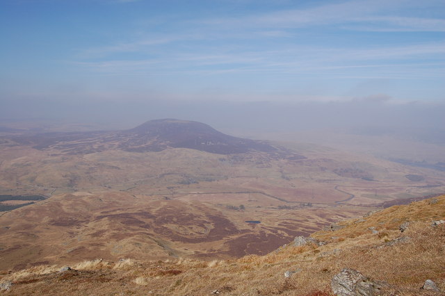
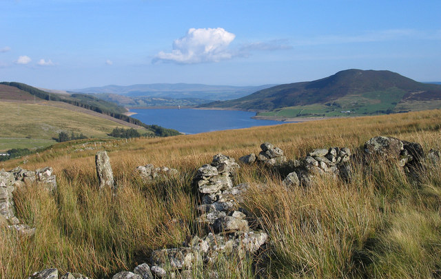
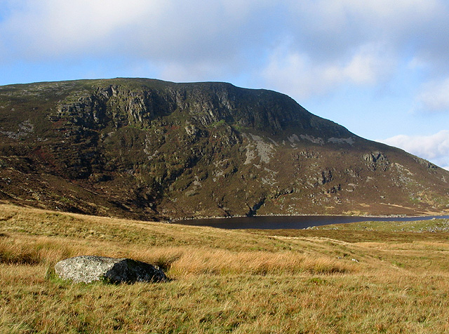
Llyn Arenig Fach is a stunning freshwater lake nestled in the heart of Merionethshire, a county in northwest Wales. This picturesque body of water is located in the Arenig mountain range, surrounded by breathtaking natural beauty and tranquil landscapes.

With a surface area of approximately 0.86 square kilometers and a maximum depth of 27 meters, Llyn Arenig Fach is the perfect spot for outdoor enthusiasts and nature lovers. The lake is fed by numerous streams and small rivers, ensuring a constant flow of crystal-clear freshwater throughout the year.

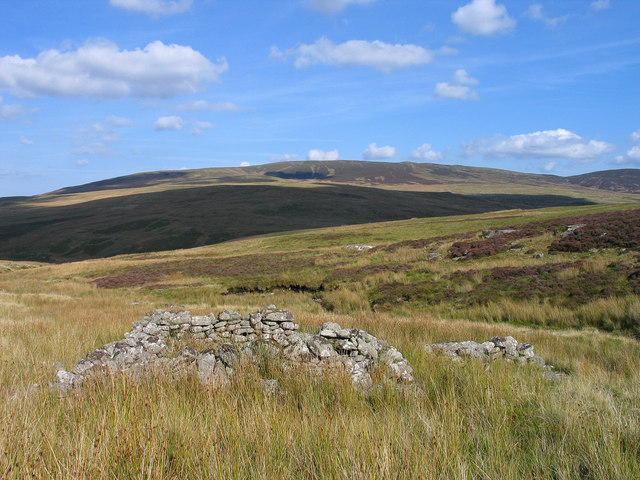
The surroundings of Llyn Arenig Fach are primarily composed of moorland and heath, creating a unique ecosystem that supports a diverse range of flora and fauna. The area is home to several species of aquatic plants, including lily pads and reeds, which provide shelter and nesting grounds for various waterfowl and other bird species.

The lake itself is a haven for fishing enthusiasts, with a healthy population of trout, perch, and pike. Anglers can enjoy a peaceful day on the water, surrounded by the peaceful sounds of nature.

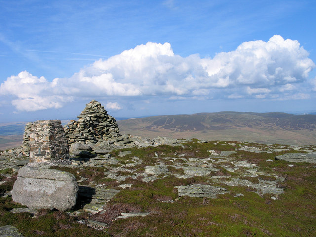
Llyn Arenig Fach also offers breathtaking views of the surrounding mountains, making it a popular destination for hikers and nature photographers. The nearby Arenig Fawr, the highest peak in the range, provides a challenging but rewarding climb for those seeking a more adventurous experience.

Overall, Llyn Arenig Fach is a hidden gem in Merionethshire, offering a peaceful retreat for those looking to immerse themselves in the beauty of nature and enjoy the serenity of a freshwater oasis.

If you have any feedback on the listing, please let us know in the comments section below.

Llyn Arenig Fach Images

Images are sourced within 2km of 52.96041/-3.7466977 or Grid Reference SH8241. Thanks to Geograph Open Source API. All images are credited.

Arenig Fach from Arenig Fawr
Looking west towards Arenig Fawr (?) From the A4212 heading towards Bala from Trawsfynydd. On a clear day unlike that in the similar shot by Nigel Brown <a title="https://www.geograph.org.uk/photo/1324971" href="https://www.geograph.org.uk/photo/1324971">Link</a>.
Looking west towards Arenig Fawr (?)
From the A4212 heading towards Bala from Trawsfynydd. On a clear day unlike that in the similar shot by Nigel Brown Link.
Ruin beside Trinant Trinant is a stream flowing in the groove passing the ruined stone feature - perhaps a sheepfold but rather small. The ruin isn't marked on OS maps at any scale but can be discerned clearly on Google Earth. Llechwedd-llyfn is the mountain dome on the skyline.
Ruin beside Trinant
Trinant is a stream flowing in the groove passing the ruined stone feature - perhaps a sheepfold but rather small. The ruin isn't marked on OS maps at any scale but can be discerned clearly on Google Earth. Llechwedd-llyfn is the mountain dome on the skyline.
Summit area of Arenig Fach The summit of Arenig Fach has minor rock exposures, a cairn and a trig point - stone built and bearing a flush bracket numbered S8547; curiously just below the FB number, a coin (1p) has been glued! The view distantly is towards the mountains of Snowdonia.
Summit area of Arenig Fach
The summit of Arenig Fach has minor rock exposures, a cairn and a trig point - stone built and bearing a flush bracket numbered S8547; curiously just below the FB number, a coin (1p) has been glued! The view distantly is towards the mountains of Snowdonia.
Walls below Clogwyn Du These walls are reached as access land ends below the roughness of Clogwyn Du which is a minor feature on the eastern side of the mountain Arenig Fach. The reservoir beyond is Llyn Celyn and the hill rising above it is Mynydd Nodol.
Walls below Clogwyn Du
These walls are reached as access land ends below the roughness of Clogwyn Du which is a minor feature on the eastern side of the mountain Arenig Fach. The reservoir beyond is Llyn Celyn and the hill rising above it is Mynydd Nodol.
The start of a re-forestation? This one small and lonely rowan tree is finding a purchase in the peat of the moor below Arenig Fach. The sheep population on the hills here is notably sparse, and a few such trees can be found in places.
The start of a re-forestation?
This one small and lonely rowan tree is finding a purchase in the peat of the moor below Arenig Fach. The sheep population on the hills here is notably sparse, and a few such trees can be found in places.
A small woodland beginning These scattered rowans and spruces are finding a living on the moors of Cefn Côch below Arenig Fach, maybe the start of more extensive woods to come.
A small woodland beginning
These scattered rowans and spruces are finding a living on the moors of Cefn Côch below Arenig Fach, maybe the start of more extensive woods to come.
County boundary stone and fenceline The stone is on a line marking the boundary between the historic Merionydd and Denbighshire counties, whilst the fence conveniently follows that boundary, but just keeps two sets of sheep apart.
County boundary stone and fenceline
The stone is on a line marking the boundary between the historic Merionydd and Denbighshire counties, whilst the fence conveniently follows that boundary, but just keeps two sets of sheep apart.
Along the old county boundary The line of the historic boundary between Merionydd and Denbighshire, which runs across these remote moors. These historic boundaries, marked through this moor by a series of stones, were pretty much abandoned as a result of the 1972 Local Government Act, which took effect a couple of years later. The fence is a more modern convenience which coincidentally runs along the same line, presumably delineating the lands of two neighbouring hillfarms.
Along the old county boundary
The line of the historic boundary between Merionydd and Denbighshire, which runs across these remote moors. These historic boundaries, marked through this moor by a series of stones, were pretty much abandoned as a result of the 1972 Local Government Act, which took effect a couple of years later. The fence is a more modern convenience which coincidentally runs along the same line, presumably delineating the lands of two neighbouring hillfarms.
Fenceline above Cefn Côch A sheep fence running up from the moors of Cefn Côch onto Arenig Fach.
Fenceline above Cefn Côch
A sheep fence running up from the moors of Cefn Côch onto Arenig Fach.
The upper part of Arenig Fach Toiling up a steep part of the little Arenig, using the fence as a guide to the summit. The deep heather and grass moorland of the Migneint persists practically to the top.
The upper part of Arenig Fach
Toiling up a steep part of the little Arenig, using the fence as a guide to the summit. The deep heather and grass moorland of the Migneint persists practically to the top.
Rather steeply downhill Steep slopes on the northern side of Arenig Fach, looking down to the moors of Cefn Côch and the valley of the Afon Conwy in the distance.
Rather steeply downhill
Steep slopes on the northern side of Arenig Fach, looking down to the moors of Cefn Côch and the valley of the Afon Conwy in the distance.
That's the hard work done... A fence corner at the top of the steep pull up from Cefn Côch. At long last, the deep heather moorland give way to shorter vegetation too.
That's the hard work done...
A fence corner at the top of the steep pull up from Cefn Côch. At long last, the deep heather moorland give way to shorter vegetation too.
Bronze Age cairn, shelter and trig on Arenig Fach A stone-built trig pillar and a rough drystone shelter at the summit of the hill. The cairn on the left is logged by Coflein at <span class="nowrap"><a title="http://coflein.gov.uk/en/site/514738/details/ARENIG+FACH%2C+CAIRN+II/" rel="nofollow ugc noopener" href="http://coflein.gov.uk/en/site/514738/details/ARENIG+FACH%2C+CAIRN+II/">Link</a><img style="margin-left:2px;" alt="External link" title="External link - shift click to open in new window" src="https://s1.geograph.org.uk/img/external.png" width="10" height="10"/></span> as one of a pair of much older Bronze Age constructions, although one suspects that it's been rebuilt using the stones of the original, rather than surviving all these years as a 7' high cairn. The other original cairn on the summit of the hill is photographed in <a href="https://www.geograph.org.uk/photo/353661">SH8241 : Carnedd y Bachgen</a>
Bronze Age cairn, shelter and trig on Arenig Fach
A stone-built trig pillar and a rough drystone shelter at the summit of the hill. The cairn on the left is logged by Coflein at LinkExternal link as one of a pair of much older Bronze Age constructions, although one suspects that it's been rebuilt using the stones of the original, rather than surviving all these years as a 7' high cairn. The other original cairn on the summit of the hill is photographed in SH8241 : Carnedd y Bachgen
OS Flush Bracket - Arenig Fach summit Flush Bracket S8547 in the trig of Arenig Fach. It's not clear why there once was a new penny-piece glued onto the bracket below the serial number - photos show it there between 2006 & March or April 2008, but it's long gone now.
OS Flush Bracket - Arenig Fach summit
Flush Bracket S8547 in the trig of Arenig Fach. It's not clear why there once was a new penny-piece glued onto the bracket below the serial number - photos show it there between 2006 & March or April 2008, but it's long gone now.
The southern ridge of Arenig Fach Looking down over Y Foel, with Arenig Fawr on the far side of the valley.
The southern ridge of Arenig Fach
Looking down over Y Foel, with Arenig Fawr on the far side of the valley.
Incipient path forming on Arenig Fach Not quite through the heather stems yet, but it'll not be much longer before boot wear this down to the peaty soil below.
Incipient path forming on Arenig Fach
Not quite through the heather stems yet, but it'll not be much longer before boot wear this down to the peaty soil below.
Summit cairn on Y Foel An outlier of Arenig Fach, Y Foel provides a grand viewpoint for Llyn Celyn to the east.
Summit cairn on Y Foel
An outlier of Arenig Fach, Y Foel provides a grand viewpoint for Llyn Celyn to the east.
Show me another place!

Llyn Arenig Fach is located at Grid Ref: SH8241 (Lat: 52.96041, Lng: -3.7466977)

Unitary Authority: Gwynedd

Police Authority: North Wales

What 3 Words

///brisk.spell.rash. Near Bala, Gwynedd

Related Wikis

Arenig Fach

Arenig Fach is a mountain in southern Snowdonia, north Wales. It is a peak in the Arenig range and lies to the north of its parent peak Arenig Fawr. It...

Capel Celyn

Capel Celyn was a rural community to the northwest of Bala in Gwynedd, Wales, in the Afon Tryweryn valley. The village and other parts of the valley were...

Arenig railway station

Arenig railway station stood beneath Arenig Fawr on the Great Western Railway's Bala Ffestiniog Line in Gwynedd, Wales. It served this thinly populated...

Capel Celyn Halt railway station

Capel Celyn Halt was a solely passenger railway station which served the rural area of Capel Celyn west of Bala. It was on the Great Western Railway's...

Nearby Amenities

Located within 500m of 52.96041,-3.7466977
Source: npe
Lat/Long: 52.9593632/-3.7446156
Source: npe
Lat/Long: 52.957897/-3.7441961
Source: npe
Lat/Long: 52.958353/-3.7478155
Source: npe
Lat/Long: 52.9593712/-3.7492601
The data included in this document is from www.openstreetmap.org. The data is made available under ODbL.

Have you been to Llyn Arenig Fach?

Leave your review of Llyn Arenig Fach below (or comments, questions and feedback).