Bugeilyn

Lake, Pool, Pond, Freshwater Marsh in Montgomeryshire

Wales

Bugeilyn

Glyndwr's Way near Glaslyn
Glyndwr's Way near Glaslyn Credit: Dave Kelly

Bugeilyn, located in Montgomeryshire, Wales, is a picturesque freshwater lake nestled amidst the beautiful countryside. Spanning an area of approximately 60 acres, it is one of the largest natural lakes in the region. Bugeilyn is surrounded by rolling hills and lush green valleys, creating a serene and tranquil atmosphere.

The lake itself is renowned for its crystal-clear waters, reflecting the surrounding landscape like a mirror. It is fed by several small streams and springs, ensuring a constant supply of fresh water. The water in Bugeilyn remains cool throughout the year, making it an ideal habitat for various species of fish, including brown trout and perch.

Surrounding the lake, there is a diverse range of vegetation, including reeds, rushes, and water lilies. This lush flora provides essential habitats for a variety of bird species, such as ducks, swans, and herons. Additionally, the lake attracts an array of migratory birds during the winter months, adding to its biodiversity.

Bugeilyn offers ample opportunities for outdoor activities and nature enthusiasts. Fishing is a popular pastime here, with anglers drawn to the abundant fish population. The lake is also a great spot for birdwatching, with several designated observation points offering panoramic views.

Access to Bugeilyn is convenient, with nearby parking facilities and walking trails leading to the lake. The surrounding area is home to a few farms and cottages, maintaining the rural charm of the region.

Overall, Bugeilyn is a natural gem in Montgomeryshire, providing a haven for wildlife, a peaceful retreat for visitors, and a place of natural beauty for all to enjoy.

If you have any feedback on the listing, please let us know in the comments section below.

Bugeilyn Images

Images are sourced within 2km of 52.515102/-3.7369079 or Grid Reference SN8292. Thanks to Geograph Open Source API. All images are credited.
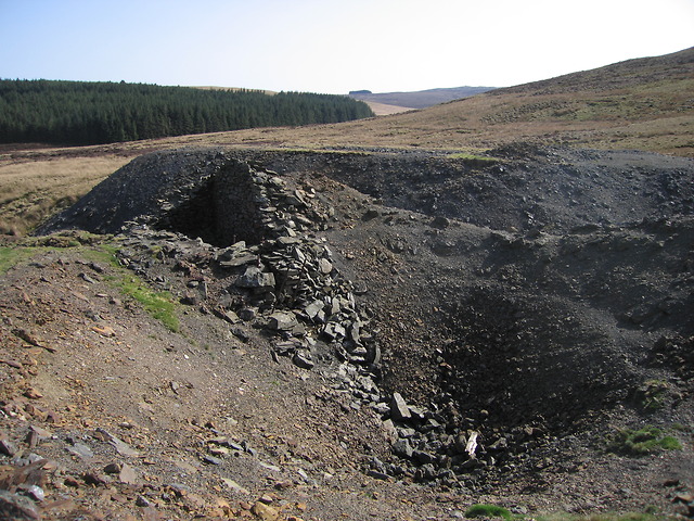
Glyndwr's Way near Glaslyn
Glaslyn The lake lies in a shallow depression in a moorland plateau.  It is separated from the craggy head of Cwm Dulas <a title="https://www.geograph.org.uk/photo/669937" href="https://www.geograph.org.uk/photo/669937">Link</a> only by a 200m wide and less than 10m high strip of slightly higher ground, seen on the right at the back in this image.
Glaslyn
The lake lies in a shallow depression in a moorland plateau. It is separated from the craggy head of Cwm Dulas Link only by a 200m wide and less than 10m high strip of slightly higher ground, seen on the right at the back in this image.
Glaslyn and Cadair Idris The view from Mynydd Esgairfochnant takes in Glaslyn in the foreground and the Cadair Idris ridge around <a href="https://www.geograph.org.uk/gridref/SH7113">SH7113</a> at the back.  In between, yet out of sight, is Machynlleth in Dyffryn Dyfi.
Glaslyn and Cadair Idris
The view from Mynydd Esgairfochnant takes in Glaslyn in the foreground and the Cadair Idris ridge around SH7113 at the back. In between, yet out of sight, is Machynlleth in Dyffryn Dyfi.
Cyfartha lead mine - shaft and engine house The crater in the foreground is one of the engine shafts, which has been backfilled after operations ceased.  To the left are the remnants of the engine house, which had a gap <a title="https://www.geograph.org.uk/photo/2373243" href="https://www.geograph.org.uk/photo/2373243">Link</a> on the side facing the shaft for the rope to pass through.  The Nant Ddu passes through the gap between the engine house and the spoil tip at the back.  The shaft <span class="nowrap"><a title="http://www.coflein.gov.uk/en/site/289540/details" rel="nofollow ugc noopener" href="http://www.coflein.gov.uk/en/site/289540/details">Link</a><img style="margin-left:2px;" alt="External link" title="External link - shift click to open in new window" src="https://s1.geograph.org.uk/img/external.png" width="10" height="10"/></span> , engine house <span class="nowrap"><a title="http://www.coflein.gov.uk/en/site/289539/details" rel="nofollow ugc noopener" href="http://www.coflein.gov.uk/en/site/289539/details">Link</a><img style="margin-left:2px;" alt="External link" title="External link - shift click to open in new window" src="https://s1.geograph.org.uk/img/external.png" width="10" height="10"/></span> and spoil tip <span class="nowrap"><a title="http://www.coflein.gov.uk/en/site/289525/details" rel="nofollow ugc noopener" href="http://www.coflein.gov.uk/en/site/289525/details">Link</a><img style="margin-left:2px;" alt="External link" title="External link - shift click to open in new window" src="https://s1.geograph.org.uk/img/external.png" width="10" height="10"/></span> all have individual entries in the Coflein database.

Cyfartha mine is also known as Nantddu mine since most of its buildings are located in the valley of the Nant Ddu.  Mine operations at Cyfartha lasted from 1842 to 1881.  The ore was mined mostly for its lead and copper content.  Cyfartha was an underground mine, with access to the levels through a number of shafts.  Power was generated using two water wheels and a horse-powered whim.  The water feeding the wheels came mainly from the Nant Ddu, supplemented by a long leat abstracting water from the Nant Goch about a kilometre to the north.  Since the water wheels are located lower than the openings of the engine shafts, power was transmitted using a flatrod system, i.e. a series of linked iron rods moving backwards and forwards as the wheel turns (see Wikipedia article on Eylesbarrow mine in Devon <span class="nowrap"><a title="http://en.wikipedia.org/wiki/Eylesbarrow_mine#The_flatrod_system" rel="nofollow ugc noopener" href="http://en.wikipedia.org/wiki/Eylesbarrow_mine#The_flatrod_system">Link</a><img style="margin-left:2px;" alt="External link" title="External link - shift click to open in new window" src="https://s1.geograph.org.uk/img/external.png" width="10" height="10"/></span> for details of the mechanism).  For a detailed description of the mine, see Clwyd-Powys Archaeological Trust <span class="nowrap"><a title="http://www.cpat.org.uk/projects/longer/mines/8497.htm" rel="nofollow ugc noopener" href="http://www.cpat.org.uk/projects/longer/mines/8497.htm">Link</a><img style="margin-left:2px;" alt="External link" title="External link - shift click to open in new window" src="https://s1.geograph.org.uk/img/external.png" width="10" height="10"/></span> .  Cyfartha mine as a whole is listed in the Coflein database <span class="nowrap"><a title="http://www.coflein.gov.uk/en/site/306327/details" rel="nofollow ugc noopener" href="http://www.coflein.gov.uk/en/site/306327/details">Link</a><img style="margin-left:2px;" alt="External link" title="External link - shift click to open in new window" src="https://s1.geograph.org.uk/img/external.png" width="10" height="10"/></span> .
Cyfartha lead mine - shaft and engine house
The crater in the foreground is one of the engine shafts, which has been backfilled after operations ceased. To the left are the remnants of the engine house, which had a gap Link on the side facing the shaft for the rope to pass through. The Nant Ddu passes through the gap between the engine house and the spoil tip at the back. The shaft LinkExternal link , engine house LinkExternal link and spoil tip LinkExternal link all have individual entries in the Coflein database. Cyfartha mine is also known as Nantddu mine since most of its buildings are located in the valley of the Nant Ddu. Mine operations at Cyfartha lasted from 1842 to 1881. The ore was mined mostly for its lead and copper content. Cyfartha was an underground mine, with access to the levels through a number of shafts. Power was generated using two water wheels and a horse-powered whim. The water feeding the wheels came mainly from the Nant Ddu, supplemented by a long leat abstracting water from the Nant Goch about a kilometre to the north. Since the water wheels are located lower than the openings of the engine shafts, power was transmitted using a flatrod system, i.e. a series of linked iron rods moving backwards and forwards as the wheel turns (see Wikipedia article on Eylesbarrow mine in Devon LinkExternal link for details of the mechanism). For a detailed description of the mine, see Clwyd-Powys Archaeological Trust LinkExternal link . Cyfartha mine as a whole is listed in the Coflein database LinkExternal link .
Cyfartha lead mine - shaft and engine house This image shows the gap in the side of the engine house <a title="https://www.geograph.org.uk/photo/2373240" href="https://www.geograph.org.uk/photo/2373240">Link</a> through which the rope would have passed down into the shaft (now backfilled) in the foreground.  The engine house <span class="nowrap"><a title="http://www.coflein.gov.uk/en/site/289539/details" rel="nofollow ugc noopener" href="http://www.coflein.gov.uk/en/site/289539/details">Link</a><img style="margin-left:2px;" alt="External link" title="External link - shift click to open in new window" src="https://s1.geograph.org.uk/img/external.png" width="10" height="10"/></span> and shaft <span class="nowrap"><a title="http://www.coflein.gov.uk/en/site/289540/details" rel="nofollow ugc noopener" href="http://www.coflein.gov.uk/en/site/289540/details">Link</a><img style="margin-left:2px;" alt="External link" title="External link - shift click to open in new window" src="https://s1.geograph.org.uk/img/external.png" width="10" height="10"/></span> are listed on the Coflein database.

Cyfartha mine is also known as Nantddu mine since most of its buildings are located in the valley of the Nant Ddu.  Mine operations at Cyfartha lasted from 1842 to 1881.  The ore was mined mostly for its lead and copper content.  Cyfartha was an underground mine, with access to the levels through a number of shafts.  Power was generated using two water wheels and a horse-powered whim.  The water feeding the wheels came mainly from the Nant Ddu, supplemented by a long leat abstracting water from the Nant Goch about a kilometre to the north.  Since the water wheels are located lower than the openings of the engine shafts, power was transmitted using a flatrod system, i.e. a series of linked iron rods moving backwards and forwards as the wheel turns (see Wikipedia article on Eylesbarrow mine in Devon <span class="nowrap"><a title="http://en.wikipedia.org/wiki/Eylesbarrow_mine#The_flatrod_system" rel="nofollow ugc noopener" href="http://en.wikipedia.org/wiki/Eylesbarrow_mine#The_flatrod_system">Link</a><img style="margin-left:2px;" alt="External link" title="External link - shift click to open in new window" src="https://s1.geograph.org.uk/img/external.png" width="10" height="10"/></span> for details of the mechanism).  For a detailed description of the mine, see Clwyd-Powys Archaeological Trust <span class="nowrap"><a title="http://www.cpat.org.uk/projects/longer/mines/8497.htm" rel="nofollow ugc noopener" href="http://www.cpat.org.uk/projects/longer/mines/8497.htm">Link</a><img style="margin-left:2px;" alt="External link" title="External link - shift click to open in new window" src="https://s1.geograph.org.uk/img/external.png" width="10" height="10"/></span> .  Cyfartha mine as a whole is listed in the Coflein database <span class="nowrap"><a title="http://www.coflein.gov.uk/en/site/306327/details" rel="nofollow ugc noopener" href="http://www.coflein.gov.uk/en/site/306327/details">Link</a><img style="margin-left:2px;" alt="External link" title="External link - shift click to open in new window" src="https://s1.geograph.org.uk/img/external.png" width="10" height="10"/></span> .
Cyfartha lead mine - shaft and engine house
This image shows the gap in the side of the engine house Link through which the rope would have passed down into the shaft (now backfilled) in the foreground. The engine house LinkExternal link and shaft LinkExternal link are listed on the Coflein database. Cyfartha mine is also known as Nantddu mine since most of its buildings are located in the valley of the Nant Ddu. Mine operations at Cyfartha lasted from 1842 to 1881. The ore was mined mostly for its lead and copper content. Cyfartha was an underground mine, with access to the levels through a number of shafts. Power was generated using two water wheels and a horse-powered whim. The water feeding the wheels came mainly from the Nant Ddu, supplemented by a long leat abstracting water from the Nant Goch about a kilometre to the north. Since the water wheels are located lower than the openings of the engine shafts, power was transmitted using a flatrod system, i.e. a series of linked iron rods moving backwards and forwards as the wheel turns (see Wikipedia article on Eylesbarrow mine in Devon LinkExternal link for details of the mechanism). For a detailed description of the mine, see Clwyd-Powys Archaeological Trust LinkExternal link . Cyfartha mine as a whole is listed in the Coflein database LinkExternal link .
Cyfartha lead mine The view follows the Nant Ddu as it runs through the surface structures of Cyfartha mine.  The photograph was taken from a spoil tip just west of one of the engine shafts.  Another spoil tip can be seen on the right, on the other side of the Nant Ddu.  The ruined building on the left is the engine house <a title="https://www.geograph.org.uk/photo/2373243" href="https://www.geograph.org.uk/photo/2373243">Link</a> , which would have housed a pulley system carrying a rope down the shaft <a title="https://www.geograph.org.uk/photo/2373243" href="https://www.geograph.org.uk/photo/2373243">Link</a> .  The shaft itself (now backfilled) is between the camera and the engine house, in the depression beyond the grassy patch on the left.  The building in the middle distance is a wheel pit <a title="https://www.geograph.org.uk/photo/2373259" href="https://www.geograph.org.uk/photo/2373259">Link</a> which once housed a water wheel driven by the Nant Ddu.  The engine house was supplied with mechanical power from this wheel pit using a flatrod system.  The engine house <span class="nowrap"><a title="http://www.coflein.gov.uk/en/site/289539/details" rel="nofollow ugc noopener" href="http://www.coflein.gov.uk/en/site/289539/details">Link</a><img style="margin-left:2px;" alt="External link" title="External link - shift click to open in new window" src="https://s1.geograph.org.uk/img/external.png" width="10" height="10"/></span> , shaft <span class="nowrap"><a title="http://www.coflein.gov.uk/en/site/289540/details" rel="nofollow ugc noopener" href="http://www.coflein.gov.uk/en/site/289540/details">Link</a><img style="margin-left:2px;" alt="External link" title="External link - shift click to open in new window" src="https://s1.geograph.org.uk/img/external.png" width="10" height="10"/></span> , spoil tip <span class="nowrap"><a title="http://www.coflein.gov.uk/en/site/289525/details" rel="nofollow ugc noopener" href="http://www.coflein.gov.uk/en/site/289525/details">Link</a><img style="margin-left:2px;" alt="External link" title="External link - shift click to open in new window" src="https://s1.geograph.org.uk/img/external.png" width="10" height="10"/></span> and wheel pit <span class="nowrap"><a title="http://www.coflein.gov.uk/en/site/289528/details" rel="nofollow ugc noopener" href="http://www.coflein.gov.uk/en/site/289528/details">Link</a><img style="margin-left:2px;" alt="External link" title="External link - shift click to open in new window" src="https://s1.geograph.org.uk/img/external.png" width="10" height="10"/></span> are all listed individually on the Coflein database.

Cyfartha mine is also known as Nantddu mine since most of its buildings are located in the valley of the Nant Ddu.  Mine operations at Cyfartha lasted from 1842 to 1881.  The ore was mined mostly for its lead and copper content.  Cyfartha was an underground mine, with access to the levels through a number of shafts.  Power was generated using two water wheels and a horse-powered whim.  The water feeding the wheels came mainly from the Nant Ddu, supplemented by a long leat abstracting water from the Nant Goch about a kilometre to the north.  Since the water wheels are located lower than the openings of the engine shafts, power was transmitted using a flatrod system, i.e. a series of linked iron rods moving backwards and forwards as the wheel turns (see Wikipedia article on Eylesbarrow mine in Devon <span class="nowrap"><a title="http://en.wikipedia.org/wiki/Eylesbarrow_mine#The_flatrod_system" rel="nofollow ugc noopener" href="http://en.wikipedia.org/wiki/Eylesbarrow_mine#The_flatrod_system">Link</a><img style="margin-left:2px;" alt="External link" title="External link - shift click to open in new window" src="https://s1.geograph.org.uk/img/external.png" width="10" height="10"/></span> for details of the mechanism).  For a detailed description of the mine, see Clwyd-Powys Archaeological Trust <span class="nowrap"><a title="http://www.cpat.org.uk/projects/longer/mines/8497.htm" rel="nofollow ugc noopener" href="http://www.cpat.org.uk/projects/longer/mines/8497.htm">Link</a><img style="margin-left:2px;" alt="External link" title="External link - shift click to open in new window" src="https://s1.geograph.org.uk/img/external.png" width="10" height="10"/></span> .  Cyfartha mine as a whole is listed in the Coflein database <span class="nowrap"><a title="http://www.coflein.gov.uk/en/site/306327/details" rel="nofollow ugc noopener" href="http://www.coflein.gov.uk/en/site/306327/details">Link</a><img style="margin-left:2px;" alt="External link" title="External link - shift click to open in new window" src="https://s1.geograph.org.uk/img/external.png" width="10" height="10"/></span> .
Cyfartha lead mine
The view follows the Nant Ddu as it runs through the surface structures of Cyfartha mine. The photograph was taken from a spoil tip just west of one of the engine shafts. Another spoil tip can be seen on the right, on the other side of the Nant Ddu. The ruined building on the left is the engine house Link , which would have housed a pulley system carrying a rope down the shaft Link . The shaft itself (now backfilled) is between the camera and the engine house, in the depression beyond the grassy patch on the left. The building in the middle distance is a wheel pit Link which once housed a water wheel driven by the Nant Ddu. The engine house was supplied with mechanical power from this wheel pit using a flatrod system. The engine house LinkExternal link , shaft LinkExternal link , spoil tip LinkExternal link and wheel pit LinkExternal link are all listed individually on the Coflein database. Cyfartha mine is also known as Nantddu mine since most of its buildings are located in the valley of the Nant Ddu. Mine operations at Cyfartha lasted from 1842 to 1881. The ore was mined mostly for its lead and copper content. Cyfartha was an underground mine, with access to the levels through a number of shafts. Power was generated using two water wheels and a horse-powered whim. The water feeding the wheels came mainly from the Nant Ddu, supplemented by a long leat abstracting water from the Nant Goch about a kilometre to the north. Since the water wheels are located lower than the openings of the engine shafts, power was transmitted using a flatrod system, i.e. a series of linked iron rods moving backwards and forwards as the wheel turns (see Wikipedia article on Eylesbarrow mine in Devon LinkExternal link for details of the mechanism). For a detailed description of the mine, see Clwyd-Powys Archaeological Trust LinkExternal link . Cyfartha mine as a whole is listed in the Coflein database LinkExternal link .
Cyfartha lead mine - wheel pit This structure once housed a water wheel, driven by water taken from the Nant Ddu (and supplemented by a leat carrying water from the Nant Goch).  The power generated here would have been transmitted mechanically to the engine house <a title="https://www.geograph.org.uk/photo/2373240" href="https://www.geograph.org.uk/photo/2373240">Link</a> next to the shaft <a title="https://www.geograph.org.uk/photo/2373243" href="https://www.geograph.org.uk/photo/2373243">Link</a> of the mine a short stretch upstream of the Nant Ddu.  The function of the structure attached to the side of the wheel pit <a title="https://www.geograph.org.uk/photo/2373261" href="https://www.geograph.org.uk/photo/2373261">Link</a> is not entirely clear to me at present. It would seem reasonable that the crank driving the flatrod system to transmit power to the engine house would have been housed in it, but I cannot see an opening for the mechanism to emerge from.  The wheel pit is listed on the Coflein[1] database <span class="nowrap"><a title="http://www.coflein.gov.uk/en/site/289528/details" rel="nofollow ugc noopener" href="http://www.coflein.gov.uk/en/site/289528/details">Link</a><img style="margin-left:2px;" alt="External link" title="External link - shift click to open in new window" src="https://s1.geograph.org.uk/img/external.png" width="10" height="10"/></span> .

Cyfartha mine is also known as Nantddu mine since most of its buildings are located in the valley of the Nant Ddu.  Mine operations at Cyfartha lasted from 1842 to 1881.  The ore was mined mostly for its lead and copper content.  Cyfartha was an underground mine, with access to the levels through a number of shafts.  Power was generated using two water wheels and a horse-powered whim.  The water feeding the wheels came mainly from the Nant Ddu, supplemented by a long leat abstracting water from the Nant Goch about a kilometre to the north.  Since the water wheels are located lower than the openings of the engine shafts, power was transmitted using a flatrod system, i.e. a series of linked iron rods moving backwards and forwards as the wheel turns (see Wikipedia article on Eylesbarrow mine in Devon <span class="nowrap"><a title="http://en.wikipedia.org/wiki/Eylesbarrow_mine#The_flatrod_system" rel="nofollow ugc noopener" href="http://en.wikipedia.org/wiki/Eylesbarrow_mine#The_flatrod_system">Link</a><img style="margin-left:2px;" alt="External link" title="External link - shift click to open in new window" src="https://s1.geograph.org.uk/img/external.png" width="10" height="10"/></span> for details of the mechanism).  For a detailed description of the mine, see Clwyd-Powys Archaeological Trust <span class="nowrap"><a title="http://www.cpat.org.uk/projects/longer/mines/8497.htm" rel="nofollow ugc noopener" href="http://www.cpat.org.uk/projects/longer/mines/8497.htm">Link</a><img style="margin-left:2px;" alt="External link" title="External link - shift click to open in new window" src="https://s1.geograph.org.uk/img/external.png" width="10" height="10"/></span> .  Cyfartha mine as whole is listed in the Coflein[1] database <span class="nowrap"><a title="http://www.coflein.gov.uk/en/site/306327/details" rel="nofollow ugc noopener" href="http://www.coflein.gov.uk/en/site/306327/details">Link</a><img style="margin-left:2px;" alt="External link" title="External link - shift click to open in new window" src="https://s1.geograph.org.uk/img/external.png" width="10" height="10"/></span> .
Cyfartha lead mine - wheel pit
This structure once housed a water wheel, driven by water taken from the Nant Ddu (and supplemented by a leat carrying water from the Nant Goch). The power generated here would have been transmitted mechanically to the engine house Link next to the shaft Link of the mine a short stretch upstream of the Nant Ddu. The function of the structure attached to the side of the wheel pit Link is not entirely clear to me at present. It would seem reasonable that the crank driving the flatrod system to transmit power to the engine house would have been housed in it, but I cannot see an opening for the mechanism to emerge from. The wheel pit is listed on the Coflein[1] database LinkExternal link . Cyfartha mine is also known as Nantddu mine since most of its buildings are located in the valley of the Nant Ddu. Mine operations at Cyfartha lasted from 1842 to 1881. The ore was mined mostly for its lead and copper content. Cyfartha was an underground mine, with access to the levels through a number of shafts. Power was generated using two water wheels and a horse-powered whim. The water feeding the wheels came mainly from the Nant Ddu, supplemented by a long leat abstracting water from the Nant Goch about a kilometre to the north. Since the water wheels are located lower than the openings of the engine shafts, power was transmitted using a flatrod system, i.e. a series of linked iron rods moving backwards and forwards as the wheel turns (see Wikipedia article on Eylesbarrow mine in Devon LinkExternal link for details of the mechanism). For a detailed description of the mine, see Clwyd-Powys Archaeological Trust LinkExternal link . Cyfartha mine as whole is listed in the Coflein[1] database LinkExternal link .
Cyfartha lead mine - wheel pit This picture shows the structure to the side of the wheel pit <a title="https://www.geograph.org.uk/photo/2373259" href="https://www.geograph.org.uk/photo/2373259">Link</a> in more detail.  It appears that there is a rectangular gap, now filled with loose rock, in the foreground, which may have housed the crank of the flatrod system. The wheel pit is listed on the Coflein database <span class="nowrap"><a title="http://www.coflein.gov.uk/en/site/289528/details" rel="nofollow ugc noopener" href="http://www.coflein.gov.uk/en/site/289528/details">Link</a><img style="margin-left:2px;" alt="External link" title="External link - shift click to open in new window" src="https://s1.geograph.org.uk/img/external.png" width="10" height="10"/></span> .

Cyfartha mine is also known as Nantddu mine since most of its buildings are located in the valley of the Nant Ddu.  Mine operations at Cyfartha lasted from 1842 to 1881.  The ore was mined mostly for its lead and copper content.  Cyfartha was an underground mine, with access to the levels through a number of shafts.  Power was generated using two water wheels and a horse-powered whim.  The water feeding the wheels came mainly from the Nant Ddu, supplemented by a long leat abstracting water from the Nant Goch about a kilometre to the north.  Since the water wheels are located lower than the openings of the engine shafts, power was transmitted using a flatrod system, i.e. a series of linked iron rods moving backwards and forwards as the wheel turns (see Wikipedia article on Eylesbarrow mine in Devon <span class="nowrap"><a title="http://en.wikipedia.org/wiki/Eylesbarrow_mine#The_flatrod_system" rel="nofollow ugc noopener" href="http://en.wikipedia.org/wiki/Eylesbarrow_mine#The_flatrod_system">Link</a><img style="margin-left:2px;" alt="External link" title="External link - shift click to open in new window" src="https://s1.geograph.org.uk/img/external.png" width="10" height="10"/></span> for details of the mechanism).  For a detailed description of the mine, see Clwyd-Powys Archaeological Trust <span class="nowrap"><a title="http://www.cpat.org.uk/projects/longer/mines/8497.htm" rel="nofollow ugc noopener" href="http://www.cpat.org.uk/projects/longer/mines/8497.htm">Link</a><img style="margin-left:2px;" alt="External link" title="External link - shift click to open in new window" src="https://s1.geograph.org.uk/img/external.png" width="10" height="10"/></span> .  Cyfartha mine as a whole is listed in the Coflein database <span class="nowrap"><a title="http://www.coflein.gov.uk/en/site/306327/details" rel="nofollow ugc noopener" href="http://www.coflein.gov.uk/en/site/306327/details">Link</a><img style="margin-left:2px;" alt="External link" title="External link - shift click to open in new window" src="https://s1.geograph.org.uk/img/external.png" width="10" height="10"/></span> .
Cyfartha lead mine - wheel pit
This picture shows the structure to the side of the wheel pit Link in more detail. It appears that there is a rectangular gap, now filled with loose rock, in the foreground, which may have housed the crank of the flatrod system. The wheel pit is listed on the Coflein database LinkExternal link . Cyfartha mine is also known as Nantddu mine since most of its buildings are located in the valley of the Nant Ddu. Mine operations at Cyfartha lasted from 1842 to 1881. The ore was mined mostly for its lead and copper content. Cyfartha was an underground mine, with access to the levels through a number of shafts. Power was generated using two water wheels and a horse-powered whim. The water feeding the wheels came mainly from the Nant Ddu, supplemented by a long leat abstracting water from the Nant Goch about a kilometre to the north. Since the water wheels are located lower than the openings of the engine shafts, power was transmitted using a flatrod system, i.e. a series of linked iron rods moving backwards and forwards as the wheel turns (see Wikipedia article on Eylesbarrow mine in Devon LinkExternal link for details of the mechanism). For a detailed description of the mine, see Clwyd-Powys Archaeological Trust LinkExternal link . Cyfartha mine as a whole is listed in the Coflein database LinkExternal link .
Cyfartha lead mine - wheel pit Looking inside the wheel pit <a title="https://www.geograph.org.uk/photo/2373259" href="https://www.geograph.org.uk/photo/2373259">Link</a> at Cyfartha mine from the downstream end.  The wheel pit is listed on the Coflein database <span class="nowrap"><a title="http://www.coflein.gov.uk/en/site/289528/details" rel="nofollow ugc noopener" href="http://www.coflein.gov.uk/en/site/289528/details">Link</a><img style="margin-left:2px;" alt="External link" title="External link - shift click to open in new window" src="https://s1.geograph.org.uk/img/external.png" width="10" height="10"/></span> .

Cyfartha mine is also known as Nantddu mine since most of its buildings are located in the valley of the Nant Ddu.  Mine operations at Cyfartha lasted from 1842 to 1881.  The ore was mined mostly for its lead and copper content.  Cyfartha was an underground mine, with access to the levels through a number of shafts.  Power was generated using two water wheels and a horse-powered whim.  The water feeding the wheels came mainly from the Nant Ddu, supplemented by a long leat abstracting water from the Nant Goch about a kilometre to the north.  Since the water wheels are located lower than the openings of the engine shafts, power was transmitted using a flatrod system, i.e. a series of linked iron rods moving backwards and forwards as the wheel turns (see Wikipedia article on Eylesbarrow mine in Devon <span class="nowrap"><a title="http://en.wikipedia.org/wiki/Eylesbarrow_mine#The_flatrod_system" rel="nofollow ugc noopener" href="http://en.wikipedia.org/wiki/Eylesbarrow_mine#The_flatrod_system">Link</a><img style="margin-left:2px;" alt="External link" title="External link - shift click to open in new window" src="https://s1.geograph.org.uk/img/external.png" width="10" height="10"/></span> for details of the mechanism).  For a detailed description of the mine, see Clwyd-Powys Archaeological Trust <span class="nowrap"><a title="http://www.cpat.org.uk/projects/longer/mines/8497.htm" rel="nofollow ugc noopener" href="http://www.cpat.org.uk/projects/longer/mines/8497.htm">Link</a><img style="margin-left:2px;" alt="External link" title="External link - shift click to open in new window" src="https://s1.geograph.org.uk/img/external.png" width="10" height="10"/></span> .  Cyfartha mine as a whole is listed in the Coflein database <span class="nowrap"><a title="http://www.coflein.gov.uk/en/site/306327/details" rel="nofollow ugc noopener" href="http://www.coflein.gov.uk/en/site/306327/details">Link</a><img style="margin-left:2px;" alt="External link" title="External link - shift click to open in new window" src="https://s1.geograph.org.uk/img/external.png" width="10" height="10"/></span> .
Cyfartha lead mine - wheel pit
Looking inside the wheel pit Link at Cyfartha mine from the downstream end. The wheel pit is listed on the Coflein database LinkExternal link . Cyfartha mine is also known as Nantddu mine since most of its buildings are located in the valley of the Nant Ddu. Mine operations at Cyfartha lasted from 1842 to 1881. The ore was mined mostly for its lead and copper content. Cyfartha was an underground mine, with access to the levels through a number of shafts. Power was generated using two water wheels and a horse-powered whim. The water feeding the wheels came mainly from the Nant Ddu, supplemented by a long leat abstracting water from the Nant Goch about a kilometre to the north. Since the water wheels are located lower than the openings of the engine shafts, power was transmitted using a flatrod system, i.e. a series of linked iron rods moving backwards and forwards as the wheel turns (see Wikipedia article on Eylesbarrow mine in Devon LinkExternal link for details of the mechanism). For a detailed description of the mine, see Clwyd-Powys Archaeological Trust LinkExternal link . Cyfartha mine as a whole is listed in the Coflein database LinkExternal link .
Cyfartha lead mine - wheel pit Here the location of the wheel pit <a title="https://www.geograph.org.uk/photo/2373259" href="https://www.geograph.org.uk/photo/2373259">Link</a> by the side of the Nant Ddu can be seen.  The stream runs in the trench beyond the structure.  The moorland in the background is Cors yr Ebolion.  The wheel pit is listed on the Coflein database <span class="nowrap"><a title="http://www.coflein.gov.uk/en/site/289528/details" rel="nofollow ugc noopener" href="http://www.coflein.gov.uk/en/site/289528/details">Link</a><img style="margin-left:2px;" alt="External link" title="External link - shift click to open in new window" src="https://s1.geograph.org.uk/img/external.png" width="10" height="10"/></span> .

Cyfartha mine is also known as Nantddu mine since most of its buildings are located in the valley of the Nant Ddu.  Mine operations at Cyfartha lasted from 1842 to 1881.  The ore was mined mostly for its lead and copper content.  Cyfartha was an underground mine, with access to the levels through a number of shafts.  Power was generated using two water wheels and a horse-powered whim.  The water feeding the wheels came mainly from the Nant Ddu, supplemented by a long leat abstracting water from the Nant Goch about a kilometre to the north.  Since the water wheels are located lower than the openings of the engine shafts, power was transmitted using a flatrod system, i.e. a series of linked iron rods moving backwards and forwards as the wheel turns (see Wikipedia article on Eylesbarrow mine in Devon <span class="nowrap"><a title="http://en.wikipedia.org/wiki/Eylesbarrow_mine#The_flatrod_system" rel="nofollow ugc noopener" href="http://en.wikipedia.org/wiki/Eylesbarrow_mine#The_flatrod_system">Link</a><img style="margin-left:2px;" alt="External link" title="External link - shift click to open in new window" src="https://s1.geograph.org.uk/img/external.png" width="10" height="10"/></span> for details of the mechanism).  For a detailed description of the mine, see Clwyd-Powys Archaeological Trust <span class="nowrap"><a title="http://www.cpat.org.uk/projects/longer/mines/8497.htm" rel="nofollow ugc noopener" href="http://www.cpat.org.uk/projects/longer/mines/8497.htm">Link</a><img style="margin-left:2px;" alt="External link" title="External link - shift click to open in new window" src="https://s1.geograph.org.uk/img/external.png" width="10" height="10"/></span> .  Cyfartha mine as a whole is listed in the Coflein database <span class="nowrap"><a title="http://www.coflein.gov.uk/en/site/306327/details" rel="nofollow ugc noopener" href="http://www.coflein.gov.uk/en/site/306327/details">Link</a><img style="margin-left:2px;" alt="External link" title="External link - shift click to open in new window" src="https://s1.geograph.org.uk/img/external.png" width="10" height="10"/></span> .
Cyfartha lead mine - wheel pit
Here the location of the wheel pit Link by the side of the Nant Ddu can be seen. The stream runs in the trench beyond the structure. The moorland in the background is Cors yr Ebolion. The wheel pit is listed on the Coflein database LinkExternal link . Cyfartha mine is also known as Nantddu mine since most of its buildings are located in the valley of the Nant Ddu. Mine operations at Cyfartha lasted from 1842 to 1881. The ore was mined mostly for its lead and copper content. Cyfartha was an underground mine, with access to the levels through a number of shafts. Power was generated using two water wheels and a horse-powered whim. The water feeding the wheels came mainly from the Nant Ddu, supplemented by a long leat abstracting water from the Nant Goch about a kilometre to the north. Since the water wheels are located lower than the openings of the engine shafts, power was transmitted using a flatrod system, i.e. a series of linked iron rods moving backwards and forwards as the wheel turns (see Wikipedia article on Eylesbarrow mine in Devon LinkExternal link for details of the mechanism). For a detailed description of the mine, see Clwyd-Powys Archaeological Trust LinkExternal link . Cyfartha mine as a whole is listed in the Coflein database LinkExternal link .
Farm buildings above the Nant Ddu Built on a large spoil tip originating from Cyfartha mine <a title="https://www.geograph.org.uk/photo/2373255" href="https://www.geograph.org.uk/photo/2373255">Link</a> and located at its eastern end, these modern farm buildings include a network of sheepfolds.  The Nant Ddu runs in a deep valley between the buildings and the forest beyond <a title="https://www.geograph.org.uk/photo/2373272" href="https://www.geograph.org.uk/photo/2373272">Link</a> .
Farm buildings above the Nant Ddu
Built on a large spoil tip originating from Cyfartha mine Link and located at its eastern end, these modern farm buildings include a network of sheepfolds. The Nant Ddu runs in a deep valley between the buildings and the forest beyond Link .
Nant Ddu at the entrance to the Clywedog gorge The Afon Clywedog is formed where the Nant Ddu and the Nant Goch merge <a title="https://www.geograph.org.uk/photo/2373279" href="https://www.geograph.org.uk/photo/2373279">Link</a> .  This picture shows the Nant Ddu just before the meeting point as it descends steeply over a large angled rock slab.  Note the trees atop the rock face for scale.
Nant Ddu at the entrance to the Clywedog gorge
The Afon Clywedog is formed where the Nant Ddu and the Nant Goch merge Link . This picture shows the Nant Ddu just before the meeting point as it descends steeply over a large angled rock slab. Note the trees atop the rock face for scale.
Nant Ddu below Cyfartha mine Looking down the spoil tip at the downstream end of the Cyfartha lead mine <a title="https://www.geograph.org.uk/photo/2373255" href="https://www.geograph.org.uk/photo/2373255">Link</a> .  The Nant Ddu can be seen below as it approaches the point where it merges with the Nant Goch to form the Afon Clywedog <a title="https://www.geograph.org.uk/photo/2373279" href="https://www.geograph.org.uk/photo/2373279">Link</a> , at the centre of the picture.  On the left, the footbridge taking the path across the Nant Goch can be seen.  The path continues to climb steeply onto the northern side of the Clyedog gorge <a title="https://www.geograph.org.uk/photo/2373305" href="https://www.geograph.org.uk/photo/2373305">Link</a> , which is hidden behind the trees on the right - there is no room for a path in it.
Nant Ddu below Cyfartha mine
Looking down the spoil tip at the downstream end of the Cyfartha lead mine Link . The Nant Ddu can be seen below as it approaches the point where it merges with the Nant Goch to form the Afon Clywedog Link , at the centre of the picture. On the left, the footbridge taking the path across the Nant Goch can be seen. The path continues to climb steeply onto the northern side of the Clyedog gorge Link , which is hidden behind the trees on the right - there is no room for a path in it.
The beginning of the Afon Clywedog Here the Nant Ddu (right) and Nant Goch (left) merge to form the Afon Clywedog which disappears round a bend into a 'gorgeous' steep-sided valley <a title="https://www.geograph.org.uk/photo/2373305" href="https://www.geograph.org.uk/photo/2373305">Link</a> .  The Afon Clywedog is the main feeder of Llyn Clywedog, a large reservoir <a title="https://www.geograph.org.uk/photo/787767" href="https://www.geograph.org.uk/photo/787767">Link</a> , and then continues to meet the Hafren/Severn at Llanidloes in <a href="https://www.geograph.org.uk/gridref/SN9584">SN9584</a> .
The beginning of the Afon Clywedog
Here the Nant Ddu (right) and Nant Goch (left) merge to form the Afon Clywedog which disappears round a bend into a 'gorgeous' steep-sided valley Link . The Afon Clywedog is the main feeder of Llyn Clywedog, a large reservoir Link , and then continues to meet the Hafren/Severn at Llanidloes in SN9584 .
Clywedog gorge The path climbs steeply up the north side of the deep cut the Afon Clywedog has dug <a title="https://www.geograph.org.uk/photo/2373305" href="https://www.geograph.org.uk/photo/2373305">Link</a> .
Clywedog gorge
The path climbs steeply up the north side of the deep cut the Afon Clywedog has dug Link .
How to make a V-shaped valley The forces of erosion can be seen in action here.  The Afon Clywedog runs in the valley.  Since it has to descend by 260m over a distance of twenty kilometres in order to meet the Hafren/Severn at Llanidloes, it has cut a sizeable gorge into the upland plateau.  The rocks on both sides of the valley are fairly crumbly, causing regular gravel avalanches and maintaining a uniform slope - the characteristic V shape <a title="https://www.geograph.org.uk/photo/2373315" href="https://www.geograph.org.uk/photo/2373315">Link</a> .  The angle of the slope is determined by the angle of repose of the gravel, which depends on factors like grain size and shape and moisture content.
How to make a V-shaped valley
The forces of erosion can be seen in action here. The Afon Clywedog runs in the valley. Since it has to descend by 260m over a distance of twenty kilometres in order to meet the Hafren/Severn at Llanidloes, it has cut a sizeable gorge into the upland plateau. The rocks on both sides of the valley are fairly crumbly, causing regular gravel avalanches and maintaining a uniform slope - the characteristic V shape Link . The angle of the slope is determined by the angle of repose of the gravel, which depends on factors like grain size and shape and moisture content.
Looking towards Foel Uchaf The footpath here (such as it is) is well above the valley floor because of the boggy ground that is found beside the river. Even at this height, wet feet and 'that sinking feeling' are a hazard for the unwary!
Looking towards Foel Uchaf
The footpath here (such as it is) is well above the valley floor because of the boggy ground that is found beside the river. Even at this height, wet feet and 'that sinking feeling' are a hazard for the unwary!
Show me another place!

Bugeilyn is located at Grid Ref: SN8292 (Lat: 52.515102, Lng: -3.7369079)

Unitary Authority: Powys

Police Authority: Dyfed Powys

What 3 Words

///swim.commands.agency. Near Staylittle, Powys

Nearby Locations

Bugeilyn Banc Bugeilyn

Related Wikis

Banc Bugeilyn

Banc Bugeilyn is a hill found in Plynlimon between Aberystwyth and Welshpool in the United Kingdom; grid reference SN826925.The summit is class as a Dewey...

Bryn yr Ŵyn

Bryn yr Ŵyn (Welsh for 'hill of the lambs') is a former Dewey in the foothills of Plynlimon between Aberystwyth and Welshpool in Wales. The summit height...

Siambr Trawsfynydd

Siambr Trawsfynydd is a mountain in Ceredigion, Wales, located to the north of Pumlumon. It is 582 m (1,910 ft) above sea level and one of the higher summits...

Clipyn Du

Clipyn Du is a mountain in northern Powys in Wales. Also known as Tarren Bwlch-Gwyn or Siambwr Trawsfynydd, it is one of the higher summits of the area...

Nearby Amenities

Located within 500m of 52.515102,-3.7369079
Source: npe
Lat/Long: 52.5182323/-3.7388995
Source: npe
Lat/Long: 52.515948/-3.7388104
Source: npe
Lat/Long: 52.5174467/-3.7385811
Banc Bugeilyn
Ele: 551
Natural: peak
Source: Bing
Wikidata: Q4854040
Wikipedia: en:Banc Bugeilyn
Lat/Long: 52.5173471/-3.7311244
The data included in this document is from www.openstreetmap.org. The data is made available under ODbL.

Have you been to Bugeilyn?

Leave your review of Bugeilyn below (or comments, questions and feedback).