Goring-by-Sea

Settlement in Sussex Worthing

England

Goring-by-Sea

Blue Waters Block of 9 flats on Sea Drive completed in 2009, replacing a mid 20th Century house named Lane End.
Blue Waters Credit: Ian Capper

Goring-by-Sea is a charming coastal village located in West Sussex, England. Situated between the towns of Worthing and Ferring, it benefits from a prime position along the south coast, offering stunning views of the English Channel. The village is part of the larger borough of Worthing and is nestled within the South Downs National Park, providing residents and visitors with access to beautiful natural surroundings.

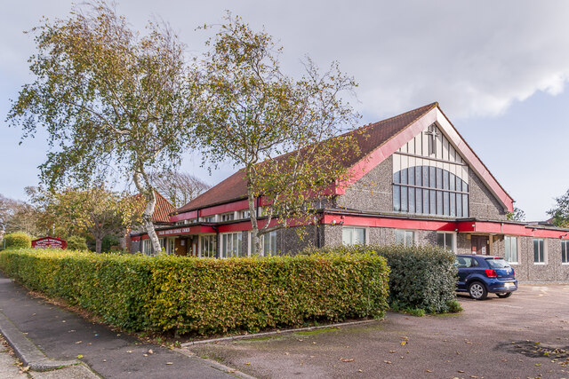
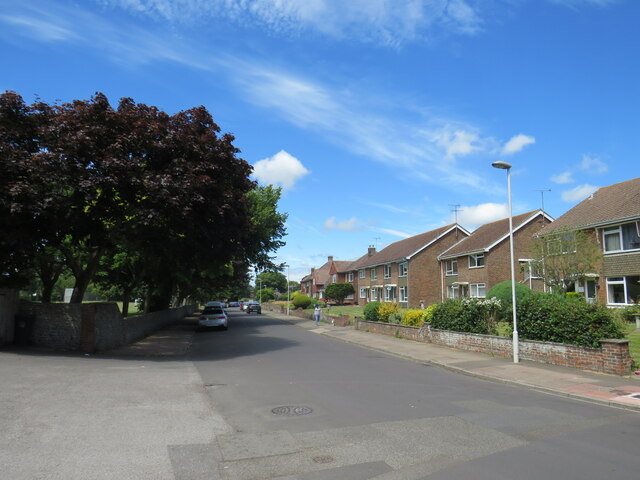
Goring-by-Sea is renowned for its peaceful and relaxed atmosphere, making it an attractive destination for those seeking a quieter coastal retreat. The village boasts a variety of amenities, including local shops, pubs, and restaurants, providing everything one might need for day-to-day living. Additionally, there are several recreational facilities, such as tennis courts and a golf course, ensuring there are plenty of opportunities for outdoor activities.

The beach at Goring-by-Sea is a popular spot for both locals and tourists. With its long stretch of sand, it offers a perfect setting for walks, picnics, and sunbathing during the summer months. The beach is also home to a sailing club, attracting water sports enthusiasts who enjoy activities such as windsurfing and kiteboarding.

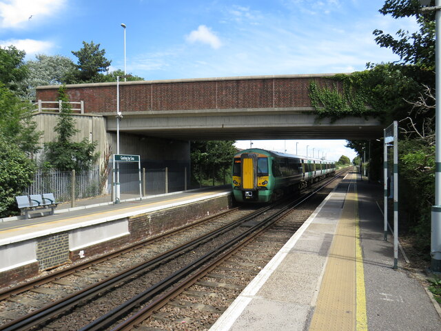
Transport links in Goring-by-Sea are excellent, with a railway station connecting the village to larger towns and cities across the region. This makes it an ideal location for commuters looking to access nearby employment centers.

In summary, Goring-by-Sea is a picturesque coastal village in West Sussex, offering a relaxed and friendly environment, stunning natural scenery, and excellent transport links. It is a sought-after destination for those seeking a peaceful coastal lifestyle.

If you have any feedback on the listing, please let us know in the comments section below.

Goring-by-Sea Images

Images are sourced within 2km of 50.815188/-0.423034 or Grid Reference TQ1102. Thanks to Geograph Open Source API. All images are credited.

Blue Waters Block of 9 flats on Sea Drive completed in 2009, replacing a mid 20th Century house named Lane End.
Blue Waters
Block of 9 flats on Sea Drive completed in 2009, replacing a mid 20th Century house named Lane End.
Ferring Village Hall on Ferring Street
Boat on the beach A boat on the beach at Goring-by-Sea.  The Code SM indicates that it is registered at Shoreham.
Boat on the beach
A boat on the beach at Goring-by-Sea. The Code SM indicates that it is registered at Shoreham.
Compton Avenue Suburban road south of Goring Way.
Compton Avenue
Suburban road south of Goring Way.
Jupp's Lane Looking across Goring Way to Jupp's Lane.
Jupp's Lane
Looking across Goring Way to Jupp's Lane.
Church of the English Martyrs Roman Catholic Church built in 1968, the congregation previously having met in the 18th Century Jupp's Barn, visible on the far left of this photo.  Although the exterior is unassuming, this is in total contrast to the interior - see <a href="https://www.geograph.org.uk/photo/7006401">TQ1002 : Ceiling, Church of the English Martyrs</a> and <a href="https://www.geograph.org.uk/photo/7006405">TQ1002 : Ceiling, Church of the English Martyrs</a>.
Church of the English Martyrs
Roman Catholic Church built in 1968, the congregation previously having met in the 18th Century Jupp's Barn, visible on the far left of this photo. Although the exterior is unassuming, this is in total contrast to the interior - see TQ1002 : Ceiling, Church of the English Martyrs and TQ1002 : Ceiling, Church of the English Martyrs.
Ceiling, Church of the English Martyrs Two-thirds replica of the Sistine Chapel in Rome on the ceiling of the Church of the English Martyrs (see <a href="https://www.geograph.org.uk/photo/7006392">TQ1002 : Church of the English Martyrs</a>), painted by parishioner Gary Bevans between 1987 and 1993.  The west window, entitled Peter the Fisherman, was designed by architectural designer and historian Annie Goodman and installed by her son, glassmaker Jeremy Goodman, in 1990.
Ceiling, Church of the English Martyrs
Two-thirds replica of the Sistine Chapel in Rome on the ceiling of the Church of the English Martyrs (see TQ1002 : Church of the English Martyrs), painted by parishioner Gary Bevans between 1987 and 1993. The west window, entitled Peter the Fisherman, was designed by architectural designer and historian Annie Goodman and installed by her son, glassmaker Jeremy Goodman, in 1990.
Ceiling, Church of the English Martyrs Two-thirds replica of the Sistine Chapel in Rome on the ceiling of the Church of the English Martyrs (see <a href="https://www.geograph.org.uk/photo/7006392">TQ1002 : Church of the English Martyrs</a>), painted by parishioner Gary Bevans between 1987 and 1993.  The "windows", which are vertical in the original, are here part of the curved ceiling (as can be seen in <a href="https://www.geograph.org.uk/photo/7006401">TQ1002 : Ceiling, Church of the English Martyrs</a>) but have been painted with appropriate perspective to appear vertical from the side, as here.
Ceiling, Church of the English Martyrs
Two-thirds replica of the Sistine Chapel in Rome on the ceiling of the Church of the English Martyrs (see TQ1002 : Church of the English Martyrs), painted by parishioner Gary Bevans between 1987 and 1993. The "windows", which are vertical in the original, are here part of the curved ceiling (as can be seen in TQ1002 : Ceiling, Church of the English Martyrs) but have been painted with appropriate perspective to appear vertical from the side, as here.
Rugby Road junction with Reigate Road Residential roads in West Worthing.
Rugby Road junction with Reigate Road
Residential roads in West Worthing.
End of Goring Road high street shops Reigate Road enters Elm Grove.
End of Goring Road high street shops
Reigate Road enters Elm Grove.
West Avenue A road with mixed housing with a walking distance from the beach.
West Avenue
A road with mixed housing with a walking distance from the beach.
West Worthing sea front houses West Parade near Wallace Avenue
West Worthing sea front houses
West Parade near Wallace Avenue
Shopping street viewed from Mill Road The western end of the Goring shops.
Shopping street viewed from Mill Road
The western end of the Goring shops.
Train leaving Goring-by-Sea station Goring-by-Sea is an intermediate station on the West Coastway line.  In this image, a Class 377 "Electrostar" train is leaving on its way to Brighton.

The railway is electrified using the third-rail system.

The bridge carries the S259 road over the railway.
Train leaving Goring-by-Sea station
Goring-by-Sea is an intermediate station on the West Coastway line. In this image, a Class 377 "Electrostar" train is leaving on its way to Brighton. The railway is electrified using the third-rail system. The bridge carries the S259 road over the railway.
Goring-by-Sea railway station Goring-by-Sea is an intermediate station on the West Coastway line, to the west of Worthing.  The railway tracks are electrified using the third-rail system.
Goring-by-Sea railway station
Goring-by-Sea is an intermediate station on the West Coastway line, to the west of Worthing. The railway tracks are electrified using the third-rail system.
Level crossing at Goring-by-Sea A level crossing takes the West Coastway line across Goring Street at Goring-by-Sea.  This road used to be part of the route of the A259 main road along the south coast.  The A259 now crosses the railway slightly to the east, over a bridge, so that 'A' road traffic is no longer halted when trains are passing.
Level crossing at Goring-by-Sea
A level crossing takes the West Coastway line across Goring Street at Goring-by-Sea. This road used to be part of the route of the A259 main road along the south coast. The A259 now crosses the railway slightly to the east, over a bridge, so that 'A' road traffic is no longer halted when trains are passing.
Chatsmore Crescent, Goring-by-Sea Chatsmore Crescent is a minor residential road in Goring-by-Sea, near Worthing.
Chatsmore Crescent, Goring-by-Sea
Chatsmore Crescent is a minor residential road in Goring-by-Sea, near Worthing.
Goring Street, Goring-by-Sea Goring Street is a residential road in Goring-by-Sea, near Worthing.
Goring Street, Goring-by-Sea
Goring Street is a residential road in Goring-by-Sea, near Worthing.
Show me another place!

Goring-by-Sea is located at Grid Ref: TQ1102 (Lat: 50.815188, Lng: -0.423034)

Administrative County: West Sussex

District: Worthing

Police Authority: Sussex

What 3 Words

///trail.combining.bricks. Near Goring-by-Sea, West Sussex

Nearby Locations

Goring-by-Sea

Related Wikis

World of Books

Wob (formerly called World of Books) is a second-hand book retailer, reported to be the United Kingdom's largest. The company buys unsold inventory of...

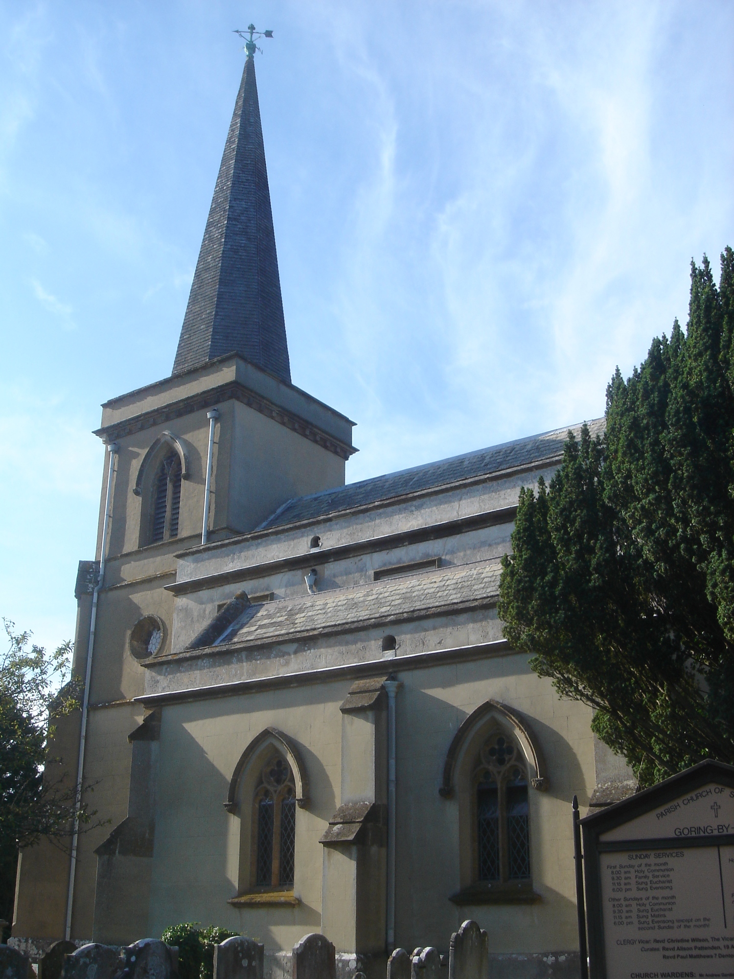
St Mary's Church, Goring-by-Sea

St Mary's Church is an Anglican church in the Goring-by-Sea area of the Borough of Worthing, one of seven local government districts in the English county...

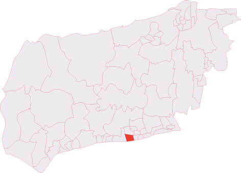
Goring (electoral division)

Goring is an electoral division of West Sussex in the United Kingdom, and returns one member to sit on West Sussex County Council. == Extent == The division...

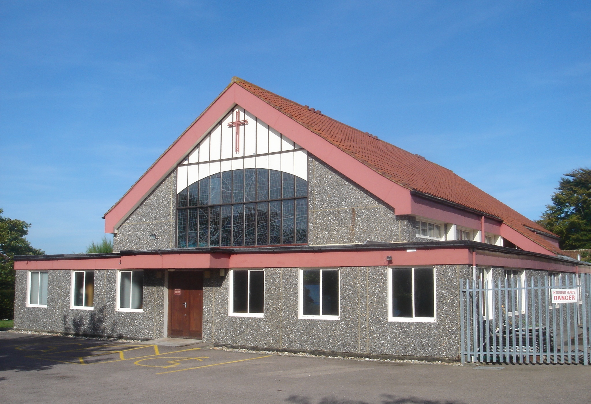
English Martyrs' Catholic Church, Goring-by-Sea

English Martyrs' Church is in Compton Avenue, Goring-by-Sea, Worthing, West Sussex, England. It is an active Roman Catholic parish church in the diocese...

Nearby Amenities

Located within 500m of 50.815188,-0.423034
Goring-by-Sea
Is In: West Sussex, England, UK
Place: village
Short Name: Goring
Source: npe
Wikidata: Q2379299
Lat/Long: 50.8126677/-0.4214561
Give Way
Direction: backward
Lat/Long: 50.8152405/-0.4236171
Noexit: yes
Lat/Long: 50.8174752/-0.4244389
Bus Stop
Limbrick Lane
Naptan AtcoCode: 4400WO0082
Naptan Bearing: W
Naptan CommonName: Limbrick Lane
Naptan Indicator: adj
Naptan Landmark: Limbrick Lane
Naptan NaptanCode: wsxdmpjw
Naptan ShortCommonName: Limbrick Lane
Naptan Street: The Strand
Naptan Verified: no
Source: naptan_import
Lat/Long: 50.8188942/-0.4244199
Bus Stop
Kipling Avenue
Naptan AtcoCode: 4400WO0084
Naptan Bearing: W
Naptan CommonName: Kipling Avenue
Naptan Indicator: adj
Naptan Landmark: Kipling Avenue
Naptan NaptanCode: wsxdmpmd
Naptan ShortCommonName: Kipling Avenue
Naptan Street: The Strand
Naptan Verified: no
Source: naptan_import
Lat/Long: 50.8188481/-0.4270053
Bus Stop
The Avenue
Naptan AtcoCode: 4400WO0197
Naptan Bearing: N
Naptan CommonName: The Avenue
Naptan Indicator: adj
Naptan Landmark: The Strand
Naptan NaptanCode: wsxdmwtd
Naptan ShortCommonName: The Avenue
Naptan Street: Maybridge Crescent
Naptan Verified: no
Source: naptan_import
Lat/Long: 50.8194631/-0.4219304
Bus Stop
Goring Road Shops
Naptan AtcoCode: 4400WO0291
Naptan Bearing: E
Naptan CommonName: Goring Road Shops
Naptan Indicator: opp
Naptan Landmark: Shops
Naptan NaptanCode: wsxdpdtm
Naptan ShortCommonName: Goring Road Shops
Naptan Street: Goring Road
Public Transport: platform
Source: naptan_import
Lat/Long: 50.8123368/-0.4197297
Bus Stop
Goring Road Shops
Naptan AtcoCode: 4400WO0292
Naptan Bearing: W
Naptan CommonName: Goring Road Shops
Naptan Indicator: adj
Naptan Landmark: Shops
Naptan NaptanCode: wsxdpdtp
Naptan ShortCommonName: Goring Road Shops
Naptan Street: Goring Road
Naptan Verified: no
Public Transport: platform
Source: naptan_import
Lat/Long: 50.8121832/-0.4202807
Bus Stop
Goring Church
Bench: yes
Bin: yes
Lit: yes
Naptan AtcoCode: 4400WO0293
Naptan Bearing: E
Naptan CommonName: Goring Church
Naptan Indicator: Adj Mulberry Gardens
Naptan Landmark: Mulberry Road
Naptan NaptanCode: wsxdpdtw
Naptan Street: Goring Road
Public Transport: platform
Shelter: yes
Source: naptan_import
Tactile Paving: no
Lat/Long: 50.8122815/-0.4224244
Bus Stop
Goring Church
Naptan AtcoCode: 4400WO0294
Naptan Bearing: W
Naptan CommonName: Goring Church
Naptan Indicator: opp
Naptan Landmark: Goring Road
Naptan NaptanCode: wsxdpdwa
Naptan Street: Ilex Way
Source: naptan_import
Lat/Long: 50.8122468/-0.4236641
Bus Stop
Goring Church
Naptan AtcoCode: 4400WO0301
Naptan Bearing: N
Naptan CommonName: Goring Church
Naptan Indicator: adj
Naptan Landmark: Public Library
Naptan NaptanCode: wsxdpgad
Naptan Street: Mulberry Lane
Public Transport: platform
Source: naptan_import
Lat/Long: 50.8130265/-0.4231949
Bus Stop
Mulberry Lane
Bench: no
Bin: no
Lit: yes
Naptan AtcoCode: 4400WO0302
Naptan Bearing: N
Naptan CommonName: Mulberry Lane
Naptan Indicator: adj Mersham Gardens
Naptan Landmark: Mersham Gardens
Naptan NaptanCode: wsxdpgag
Naptan Street: Mulberry Lane
Naptan Verified: no
Public Transport: platform
Shelter: no
Source: naptan_import
Tactile Paving: no
Lat/Long: 50.8145316/-0.4237007
Bus Stop
Mulberry Lane
Naptan AtcoCode: 4400WO0303
Naptan Bearing: S
Naptan CommonName: Mulberry Lane
Naptan Indicator: Opp Mersham Gardens
Naptan Landmark: Mersham Gardens
Naptan NaptanCode: wsxdpgaj
Naptan Street: Mulberry Lane
Public Transport: platform
Shelter: no
Source: naptan_import
Lat/Long: 50.8147287/-0.4235275
Bus Stop
Jupp's Lane
Bench: yes
Bin: yes
Lit: yes
Naptan AtcoCode: 4400WO0304
Naptan Bearing: W
Naptan CommonName: Jupp's Lane
Naptan Indicator: adj Comptons Ave
Naptan Landmark: Compton Avenue
Naptan NaptanCode: wsxdpgam
Naptan Street: Goring Way
Public Transport: platform
Shelter: no
Source: naptan_import
Tactile Paving: no
Lat/Long: 50.815871/-0.4264027
Bus Stop
Jupp's Lane
Bench: yes
Bin: yes
Lit: yes
Naptan AtcoCode: 4400WO0305
Naptan Bearing: E
Naptan CommonName: Jupp's Lane
Naptan Indicator: Opp Comptons Ave
Naptan Landmark: Jupp's Lane
Naptan NaptanCode: wsxdpgap
Naptan Street: Goring Way
Public Transport: platform
Shelter: yes
Source: naptan_import
Tactile Paving: no
Lat/Long: 50.8160741/-0.4268251
Bus Stop
Aldsworth Avenue
Alt Name: National Express Stop
Bus: yes
Naptan AltCommonName: National Express Stop
Naptan AltStreet: Not Specified
Naptan AtcoCode: 4400WO0306
Naptan Bearing: W
Naptan BusStopType: CUS
Naptan CommonName: Aldsworth Avenue
Naptan Indicator: Opp
Naptan Landmark: Denton Close
Naptan NaptanCode: wsxdpgat
Naptan Street: Goring Way
Public Transport: platform
Source: naptan_import
Lat/Long: 50.8159995/-0.4299556
Bus Stop
Aldsworth Avenue
Alt Name: DELETED RECORD
Bench: yes
Bin: yes
Bus: yes
Lit: yes
Naptan AltCommonName: DELETED RECORD
Naptan AltStreet: Not Specified
Naptan AtcoCode: 4400WO0307
Naptan Bearing: E
Naptan CommonName: Aldsworth Avenue
Naptan Indicator: Adj
Naptan Landmark: Denton Close
Naptan NaptanCode: wsxdpgaw
Naptan Street: Goring Way
Public Transport: platform
Shelter: yes
Source: naptan_import
Tactile Paving: no
Lat/Long: 50.8161356/-0.4299357
Turning Circle
Lat/Long: 50.8177206/-0.4207354
Crossing
Crossing: unmarked
Crossing Island: no
Crossing Markings: no
Kerb: lowered
Tactile Paving: yes
Lat/Long: 50.8123007/-0.4222074
Post Box
Brand: Royal Mail
Brand Wikidata: Q638098
Brand Wikipedia: en:Royal Mail
Collection Plate: CP1D
Collection Times: Mo-Fr 09:00; Sa 07:00
Last Checked: 2020-10-16
Operator: Royal Mail
Operator Wikidata: Q638098
Post Box Type: pillar
Ref: BN12 1812D
Royal Cypher: GVIR
Royal Cypher Wikidata: Q33102169
Source: survey
Lat/Long: 50.8153017/-0.4173004
Post Box
Brand: Royal Mail
Brand Wikidata: Q638098
Brand Wikipedia: en:Royal Mail
Collection Plate: CP1D
Collection Times: Mo-Fr 09:00; Sa 07:00
Operator: Royal Mail
Operator Wikidata: Q638098
Post Box Type: pillar
Ref: BN12 1808D
Royal Cypher: GR
Royal Cypher Wikidata: Q33102273
Lat/Long: 50.8131308/-0.4268467
Post Box
Brand: Royal Mail
Brand Wikidata: Q638098
Brand Wikipedia: en:Royal Mail
Collection Plate: CP7D
Collection Times: Mo-Fr 09:00; Sa 07:00
Operator: Royal Mail
Operator Wikidata: Q638098
Post Box Type: lamp
Ref: BN12 1806D
Royal Cypher: EIIR
Royal Cypher Wikidata: Q33102113
Lat/Long: 50.8161355/-0.4296655
Noexit: yes
Lat/Long: 50.8132857/-0.4223394
Generator Method: photovoltaic
Generator Output Electricity: yes
Generator Source: solar
Generator Type: solar_photovoltaic_panel
Location: roof
Power: generator
Lat/Long: 50.8114084/-0.4194545
Generator Method: photovoltaic
Generator Output Electricity: yes
Generator Source: solar
Generator Type: solar_photovoltaic_panel
Location: roof
Power: generator
Lat/Long: 50.8113168/-0.4194418
Generator Method: photovoltaic
Generator Output Electricity: yes
Generator Source: solar
Generator Type: solar_photovoltaic_panel
Location: roof
Power: generator
Lat/Long: 50.8113534/-0.4203209
Generator Method: photovoltaic
Generator Output Electricity: yes
Generator Source: solar
Generator Type: solar_photovoltaic_panel
Location: roof
Power: generator
Lat/Long: 50.8185317/-0.418597
Generator Method: photovoltaic
Generator Output Electricity: yes
Generator Source: solar
Generator Type: solar_photovoltaic_panel
Location: roof
Power: generator
Lat/Long: 50.8148742/-0.4284924
Generator Method: photovoltaic
Generator Output Electricity: yes
Generator Source: solar
Generator Type: solar_photovoltaic_panel
Location: roof
Power: generator
Lat/Long: 50.8145986/-0.4250635
Generator Method: photovoltaic
Generator Output Electricity: yes
Generator Source: solar
Generator Type: solar_photovoltaic_panel
Location: roof
Power: generator
Lat/Long: 50.8153747/-0.4265762
Generator Method: photovoltaic
Generator Output Electricity: yes
Generator Source: solar
Generator Type: solar_photovoltaic_panel
Location: roof
Power: generator
Lat/Long: 50.8148658/-0.4182647
Generator Method: photovoltaic
Generator Output Electricity: yes
Generator Source: solar
Generator Type: solar_photovoltaic_panel
Location: roof
Power: generator
Lat/Long: 50.8149295/-0.4182756
Generator Method: photovoltaic
Generator Output Electricity: yes
Generator Source: solar
Generator Type: solar_photovoltaic_panel
Location: roof
Power: generator
Lat/Long: 50.8131623/-0.4175377
Generator Method: photovoltaic
Generator Output Electricity: yes
Generator Source: solar
Generator Type: solar_photovoltaic_panel
Location: roof
Power: generator
Lat/Long: 50.8131482/-0.4179499
Generator Method: photovoltaic
Generator Output Electricity: yes
Generator Source: solar
Generator Type: solar_photovoltaic_panel
Location: roof
Power: generator
Lat/Long: 50.8130978/-0.4184891
Generator Method: photovoltaic
Generator Output Electricity: yes
Generator Source: solar
Generator Type: solar_photovoltaic_panel
Location: roof
Power: generator
Lat/Long: 50.8129787/-0.4278794
Generator Method: photovoltaic
Generator Output Electricity: yes
Generator Source: solar
Generator Type: solar_photovoltaic_panel
Location: roof
Power: generator
Lat/Long: 50.8119234/-0.4250775
Generator Method: photovoltaic
Generator Output Electricity: yes
Generator Source: solar
Generator Type: solar_photovoltaic_panel
Location: roof
Power: generator
Lat/Long: 50.8111385/-0.4247881
Generator Method: photovoltaic
Generator Output Electricity: yes
Generator Source: solar
Generator Type: solar_photovoltaic_panel
Location: roof
Power: generator
Lat/Long: 50.8178366/-0.4283941
Generator Method: photovoltaic
Generator Output Electricity: yes
Generator Source: solar
Generator Type: solar_photovoltaic_panel
Location: roof
Power: generator
Lat/Long: 50.8183699/-0.4273946
Generator Method: photovoltaic
Generator Output Electricity: yes
Generator Source: solar
Generator Type: solar_photovoltaic_panel
Location: roof
Power: generator
Lat/Long: 50.8154886/-0.4178292
Waste Basket
Ashtray: no
Colour: red
Covered: yes
Source: survey
Lat/Long: 50.8190797/-0.4238427
Bus Stop
Bus: yes
Naptan AtcoCode: 4400WO0081
Naptan NaptanCode: wsxdmpjt
Public Transport: platform
Shelter: no
Source: survey
Lat/Long: 50.8190553/-0.4238359
Waste Basket
Ashtray: no
Colour: black
Covered: yes
Operator: Adur & Worthing Council Services
Source: survey
Lat/Long: 50.8189406/-0.4241355
Post Box
Brand: Royal Mail
Brand Wikidata: Q638098
Brand Wikipedia: en:Royal Mail
Collection Plate: CP1D
Collection Times: Mo-Fr 09:00; Sa 07:00
Last Checked: 2020-10-16
Operator: Royal Mail
Operator Wikidata: Q638098
Post Box Type: pillar
Ref: BN12 1637D
Royal Cypher: GVIR
Royal Cypher Wikidata: Q33102169
Source: survey
Lat/Long: 50.8189217/-0.4243183
Waste Basket
Ashtray: no
Colour: black
Covered: yes
Operator: Adur & Worthing Council Services
Source: survey
Lat/Long: 50.8145704/-0.4169357
Crossing
Bicycle: yes
Crossing: unmarked
Crossing Island: no
Crossing Markings: no
Kerb: lowered
Tactile Paving: no
Lat/Long: 50.812247/-0.4207893
Give Way
Direction: backward
Lat/Long: 50.811144/-0.4239591
Crossing
Crossing: unmarked
Crossing Island: no
Crossing Markings: no
Kerb: lowered
Tactile Paving: no
Lat/Long: 50.812184/-0.4246448
Crossing
Crossing: unmarked
Crossing Island: no
Crossing Markings: no
Kerb: lowered
Tactile Paving: no
Lat/Long: 50.8122683/-0.4246477
Crossing
Crossing: unmarked
Crossing Island: no
Crossing Markings: no
Kerb: lowered
Tactile Paving: no
Lat/Long: 50.8124288/-0.4242271
Crossing
Crossing: unmarked
Crossing Island: yes
Crossing Markings: no
Kerb: lowered
Tactile Paving: no
Lat/Long: 50.8122645/-0.423942
Crossing
Crossing: unmarked
Crossing Island: no
Crossing Markings: no
Kerb: lowered
Tactile Paving: no
Lat/Long: 50.8119919/-0.4243266
Crossing
Crossing: unmarked
Crossing Island: no
Crossing Markings: no
Kerb: lowered
Tactile Paving: no
Lat/Long: 50.8119996/-0.4241801
Crossing
Crossing: unmarked
Crossing Island: no
Crossing Markings: no
Kerb: lowered
Tactile Paving: no
Lat/Long: 50.8122872/-0.4207917
Crossing
Crossing: unmarked
Crossing Island: no
Crossing Markings: no
Kerb: lowered
Tactile Paving: no
Lat/Long: 50.8121258/-0.4209864
Crossing
Crossing: unmarked
Crossing Island: no
Crossing Markings: no
Kerb: lowered
Tactile Paving: no
Lat/Long: 50.8122763/-0.4216707
Crossing
Crossing: traffic_signals
Lat/Long: 50.8122076/-0.4220174
Crossing
Crossing: unmarked
Crossing Island: no
Crossing Markings: no
Kerb: lowered
Tactile Paving: no
Lat/Long: 50.8121282/-0.4213527
Crossing
Crossing: unmarked
Crossing Island: no
Crossing Markings: no
Kerb: lowered
Tactile Paving: no
Lat/Long: 50.812161/-0.4222068
Crossing
Crossing: unmarked
Crossing Island: yes
Crossing Markings: no
Kerb: lowered
Tactile Paving: yes
Lat/Long: 50.8123696/-0.4233053
Crossing
Bicycle: yes
Crossing: unmarked
Crossing Island: yes
Crossing Markings: no
Kerb: lowered
Tactile Paving: yes
Lat/Long: 50.8124902/-0.4231534
Give Way
Lat/Long: 50.8131355/-0.4269929
Dillistone of Goring Funeral Directors
Shop: funeral_directors
Lat/Long: 50.812425/-0.4206239
Post Box
Operator: Royal Mail
Operator Wikidata: Q638098
Lat/Long: 50.8122764/-0.4211037
Noexit: yes
Lat/Long: 50.8134004/-0.4223585
Give Way
Direction: backward
Lat/Long: 50.8150132/-0.4238449
Give Way
Direction: backward
Lat/Long: 50.8141598/-0.4234642
Traffic Signals
Crossing: no
Traffic Signals: pedestrian_crossing
Traffic Signals Direction: forward
Lat/Long: 50.8134873/-0.4231429
Crossing
Button Operated: yes
Crossing: traffic_signals
Crossing Island: no
Crossing Markings: dots
Crossing Ref: puffin
Kerb: lowered
Tactile Paving: yes
Lat/Long: 50.8135207/-0.4231536
Traffic Signals
Crossing: no
Traffic Signals: pedestrian_crossing
Traffic Signals Direction: backward
Lat/Long: 50.8135541/-0.4231643
Give Way
Direction: backward
Lat/Long: 50.8169995/-0.4244105
Bicycle Rental
Goring Road (Mulberry Lane)
Bicycle Rental: docking_station
Covered: no
Fee: yes
Network: Adur&Worthing
Operator: Donkey Republic
Payment App: yes
Website: https://www.donkey.bike/cities/bike-rental-worthing/
Lat/Long: 50.8122533/-0.4217754
Crossing
Crossing: unmarked
Crossing Island: no
Crossing Markings: no
Kerb: lowered
Tactile Paving: no
Lat/Long: 50.8121427/-0.4218484
Crossing
Crossing: unmarked
Crossing Island: yes
Crossing Markings: no
Kerb: lowered
Tactile Paving: no
Lat/Long: 50.812322/-0.4230648
Crossing
Crossing: unmarked
Crossing Island: no
Crossing Markings: no
Kerb: lowered
Tactile Paving: yes
Lat/Long: 50.8141563/-0.4234904
Crossing
Crossing: unmarked
Crossing Island: no
Crossing Markings: no
Kerb: lowered
Tactile Paving: no
Lat/Long: 50.8152364/-0.4235787
Crossing
Crossing: unmarked
Crossing Island: no
Crossing Markings: no
Kerb: lowered
Tactile Paving: no
Lat/Long: 50.8151608/-0.4243953
Crossing
Crossing: unmarked
Crossing Island: no
Crossing Markings: no
Kerb: lowered
Tactile Paving: no
Lat/Long: 50.8159429/-0.4268241
Crossing
Crossing: unmarked
Crossing Island: no
Crossing Markings: no
Kerb: lowered
Tactile Paving: no
Lat/Long: 50.8150418/-0.4238032
Crossing
Crossing: unmarked
Crossing Island: no
Crossing Markings: no
Kerb: lowered
Tactile Paving: no
Lat/Long: 50.8159987/-0.4263554
The data included in this document is from www.openstreetmap.org. The data is made available under ODbL.

Have you been to Goring-by-Sea?

Leave your review of Goring-by-Sea below (or comments, questions and feedback).