Poll na Bracha

Lake, Pool, Pond, Freshwater Marsh in Inverness-shire

Scotland

Poll na Bracha

Spey Reservoir
Spey Reservoir Credit: Peter Moore

The requested URL returned error: 429 Too Many Requests

If you have any feedback on the listing, please let us know in the comments section below.

Poll na Bracha Images

Images are sourced within 2km of 57.015304/-4.3197228 or Grid Reference NN5993. Thanks to Geograph Open Source API. All images are credited.

Spey Reservoir
Spey Reservoir
Low water at the Spey Dam
Laggan to Garva road By Blargie
Laggan to Garva road
By Blargie
Beside the Spey Flowers on a bank between river and road.
Beside the Spey
Flowers on a bank between river and road.
River Spey View towards Dùn-da-lamh.
River Spey
View towards Dùn-da-lamh.
Road beside Spey Dam The Spey has been dammed here so that water can be fed into the Glen Spean catchment for electricity generation. The power is used for aluminium smelting at Fort William.
Road beside Spey Dam
The Spey has been dammed here so that water can be fed into the Glen Spean catchment for electricity generation. The power is used for aluminium smelting at Fort William.
Spey Reservoir
Spey Reservoir
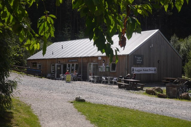
Cafe, Wolftrax New building at the Laggan trail centre.  It replaces <a href="https://www.geograph.org.uk/photo/2256004">NN5992 : Cafe, Wolftrax</a>.
Cafe, Wolftrax
New building at the Laggan trail centre. It replaces NN5992 : Cafe, Wolftrax.
Wolftrax car park The trail centre at Laggan.  Looking towards the site of the old cafe building, now replaced.
Wolftrax car park
The trail centre at Laggan. Looking towards the site of the old cafe building, now replaced.
Forestry track, Strath Mashie Looking towards the Loch Laggan hills from a forest track NW of the Wolftrax mountain bike area.
Forestry track, Strath Mashie
Looking towards the Loch Laggan hills from a forest track NW of the Wolftrax mountain bike area.
The new cafe, Wolftrax Laggan Community Cafe at the mountain bike trail centre.
The new cafe, Wolftrax
Laggan Community Cafe at the mountain bike trail centre.
Start banner, Wolftrax Laggan community woodlands.
Start banner, Wolftrax
Laggan community woodlands.
Almost as much fun as Chemistry A banner at the Wolftrax trail centre. They have got boron and sulfur correct.  (I prefer sulphur, but IUPAC!)
Almost as much fun as Chemistry
A banner at the Wolftrax trail centre. They have got boron and sulfur correct. (I prefer sulphur, but IUPAC!)
View down Strath Mashie Looking in a north easterly direction down Strath Mashie from the hillside in Black Wood. Once the trees beside the track grow this view will be obscured by the trees.
View down Strath Mashie
Looking in a north easterly direction down Strath Mashie from the hillside in Black Wood. Once the trees beside the track grow this view will be obscured by the trees.
Cairngorms Scenic Photo Post 18 One of 24 Scenic Photo Posts dotted around the Cairngorms National Park. The National Park's website <span class="nowrap"><a title="http://cairngorms.co.uk/photo-posts/" rel="nofollow ugc noopener" href="http://cairngorms.co.uk/photo-posts/">Link</a><img style="margin-left:2px;" alt="External link" title="External link - shift click to open in new window" src="https://s1.geograph.org.uk/img/external.png" width="10" height="10"/></span> says they are part of a project to "create a visual record of our changing landscape" through members of public uploading their photos taken from the viewpoint to a dedicated website. <a href="https://www.geograph.org.uk/photo/5871741">NN5892 : Scenic Photo Post 18</a> shows the location of the post and <a href="https://www.geograph.org.uk/photo/5871733">NN5892 : View from Cairngorms Scenic Photo Post 18</a> is a photo taken by resting my camera on the post using the metal angle on top as a guide.
Cairngorms Scenic Photo Post 18
One of 24 Scenic Photo Posts dotted around the Cairngorms National Park. The National Park's website LinkExternal link says they are part of a project to "create a visual record of our changing landscape" through members of public uploading their photos taken from the viewpoint to a dedicated website. NN5892 : Scenic Photo Post 18 shows the location of the post and NN5892 : View from Cairngorms Scenic Photo Post 18 is a photo taken by resting my camera on the post using the metal angle on top as a guide.
View from Cairngorms Scenic Photo Post 18 A photo taken by placing my camera on top of the post as seen in <a href="https://www.geograph.org.uk/photo/5871725">NN5892 : Cairngorms Scenic Photo Post 18</a>. The location of the post within the forest can be seen in <a href="https://www.geograph.org.uk/photo/5871741">NN5892 : Scenic Photo Post 18</a>. The post is one of 24 dotted around the Cairngorms National Park. The National Park's website <span class="nowrap"><a title="http://cairngorms.co.uk/photo-posts/" rel="nofollow ugc noopener" href="http://cairngorms.co.uk/photo-posts/">Link</a><img style="margin-left:2px;" alt="External link" title="External link - shift click to open in new window" src="https://s1.geograph.org.uk/img/external.png" width="10" height="10"/></span> says they are part of a project to "create a visual record of our changing landscape" through members of public uploading their photos taken from the viewpoint to a dedicated website. At some point in the coming years the growth of the trees in the foreground will reduce the view in this direction to metres rather than miles.
View from Cairngorms Scenic Photo Post 18
A photo taken by placing my camera on top of the post as seen in NN5892 : Cairngorms Scenic Photo Post 18. The location of the post within the forest can be seen in NN5892 : Scenic Photo Post 18. The post is one of 24 dotted around the Cairngorms National Park. The National Park's website LinkExternal link says they are part of a project to "create a visual record of our changing landscape" through members of public uploading their photos taken from the viewpoint to a dedicated website. At some point in the coming years the growth of the trees in the foreground will reduce the view in this direction to metres rather than miles.
Scenic Photo Post 18 A view up Strath Mashie from with Black Wood. The post in the foreground is one of 24 Scenic Photo Posts dotted around the Cairngorms National Park. The National Park's website <span class="nowrap"><a title="http://cairngorms.co.uk/photo-posts/" rel="nofollow ugc noopener" href="http://cairngorms.co.uk/photo-posts/">Link</a><img style="margin-left:2px;" alt="External link" title="External link - shift click to open in new window" src="https://s1.geograph.org.uk/img/external.png" width="10" height="10"/></span> says they are part of a project to "create a visual record of our changing landscape" through members of public uploading their photos taken from the viewpoint to a dedicated website. <a href="https://www.geograph.org.uk/photo/5871725">NN5892 : Cairngorms Scenic Photo Post 18</a> shows the top of the post in detail and <a href="https://www.geograph.org.uk/photo/5871733">NN5892 : View from Cairngorms Scenic Photo Post 18</a> is a photo taken by resting my camera on the post using the metal angle on top as a guide.
Scenic Photo Post 18
A view up Strath Mashie from with Black Wood. The post in the foreground is one of 24 Scenic Photo Posts dotted around the Cairngorms National Park. The National Park's website LinkExternal link says they are part of a project to "create a visual record of our changing landscape" through members of public uploading their photos taken from the viewpoint to a dedicated website. NN5892 : Cairngorms Scenic Photo Post 18 shows the top of the post in detail and NN5892 : View from Cairngorms Scenic Photo Post 18 is a photo taken by resting my camera on the post using the metal angle on top as a guide.
Felled block in Black Wood A large empty block of forest within Black Wood.
Felled block in Black Wood
A large empty block of forest within Black Wood.
Show me another place!

Poll na Bracha is located at Grid Ref: NN5993 (Lat: 57.015304, Lng: -4.3197228)

Unitary Authority: Highland

Police Authority: Highlands and Islands

What 3 Words

///grove.melon.direct. Near Newtonmore, Highland

Nearby Locations

Eilean Dubh Poll na Bracha

Related Wikis

Dùn dà Làmh

Dùn dà Làmh is a Pictish now ruined hill fort near Laggan in the Scottish Highlands. It became a scheduled monument in 1986, with an extension to the protected...

Laggan, Badenoch

Laggan (Gaelic: Lagan ) is a village in Badenoch, in the Highland region of Scotland. It is beside the River Spey, about 10 km west of Newtonmore. The...

Catlodge

Catlodge (Scottish Gaelic: Caitleag) is a hamlet, in the district of Newtonmore in Inverness-shire, Scottish Highlands and is in the Scottish council...

Falls of Pattack

Falls of Pattack is a waterfall in the Scottish Highlands' Cairngorm National Park. The falls are on the River Pattack, about 2 km south of the A86 road...

Nearby Amenities

Located within 500m of 57.015304,-4.3197228
Power: pole
Lat/Long: 57.0160401/-4.3273197
Frequency: 50
Phases: 2
Power: pole
Transformer: distribution
Voltage Primary: 11000
Voltage Secondary: 400
Lat/Long: 57.0155946/-4.3270912
Power: pole
Lat/Long: 57.0152927/-4.3269165
Power: pole
Lat/Long: 57.014763/-4.3266426
Power: pole
Lat/Long: 57.0139909/-4.3262191
Power: pole
Lat/Long: 57.0132819/-4.3258494
Power: pole
Lat/Long: 57.0125665/-4.3254495
Dalchully
Place: hamlet
Lat/Long: 57.0122619/-4.3153211
The data included in this document is from www.openstreetmap.org. The data is made available under ODbL.

Have you been to Poll na Bracha?

Leave your review of Poll na Bracha below (or comments, questions and feedback).