Carbeth Loch

Lake, Pool, Pond, Freshwater Marsh in Stirlingshire

Scotland

Carbeth Loch

Arlehaven Located next to West Highland Way
Arlehaven Credit: Iain Thompson

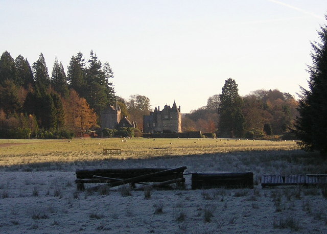
Carbeth Loch is a picturesque freshwater loch located in Stirlingshire, Scotland. Covering an area of approximately 30 acres, it is nestled amidst the scenic beauty of the Carbeth Estate. The loch is surrounded by lush greenery, rolling hills, and dense forests, making it a popular destination for nature lovers and outdoor enthusiasts.

The loch itself is a tranquil body of water, known for its crystal-clear and calm surface. It is fed by several small streams that flow from the surrounding hills, ensuring a constant supply of freshwater. The depth of the loch varies, with some areas reaching up to 15 feet deep. The water is teeming with various species of fish, making it a favorite spot for anglers.

Carbeth Loch is also home to a diverse range of wildlife, both on and around the water. Birdwatchers can spot a variety of species, including herons, swans, ducks, and geese, particularly during the migration seasons. The surrounding marshes provide a habitat for numerous amphibians, insects, and small mammals.

Visitors to Carbeth Loch can enjoy a range of activities. Fishing is a popular pastime, with the loch offering the chance to catch trout, pike, and perch. The tranquil surroundings also make it an ideal spot for picnics, leisurely walks, and wildlife photography. Additionally, the nearby Carbeth Estate provides ample opportunities for hiking, cycling, and exploring the enchanting Scottish countryside.

In summary, Carbeth Loch is a scenic and serene freshwater loch, offering a haven for wildlife and a multitude of recreational activities. Its natural beauty and peaceful ambiance make it a cherished destination for locals and tourists alike.

If you have any feedback on the listing, please let us know in the comments section below.

Carbeth Loch Images

Images are sourced within 2km of 55.984634/-4.3504164 or Grid Reference NS5379. Thanks to Geograph Open Source API. All images are credited.

Arlehaven Located next to West Highland Way
Arlehaven
Located next to West Highland Way
Duntreath Castle, Strath Blane
View Across Strath Blane
West Highland Way Near Dumgoyach
Arlehaven on the West Highland Way The path of the West Highland Way can be seen with Dumgoyne in the background.
Arlehaven on the West Highland Way
The path of the West Highland Way can be seen with Dumgoyne in the background.
Dumgoyach with Dumgoyne in the background Dumgoyach with Dumgoyne in the background viewed from the West Highland Way.
Dumgoyach with Dumgoyne in the background
Dumgoyach with Dumgoyne in the background viewed from the West Highland Way.
Oops! You missed us Interesting sign encouraging us back to the Edenmill farm shop.
Oops! You missed us
Interesting sign encouraging us back to the Edenmill farm shop.
Remains of Arlehaven Some mishap has befallen the house at Arlehaven, its previous, idyllic state shown in <a href="https://www.geograph.org.uk/photo/80349">NS5380 : Arlehaven</a>. The pile of stones to the right, just below halfway, seems to be all that remains, plus some abandoned electrical appliances.
Remains of Arlehaven
Some mishap has befallen the house at Arlehaven, its previous, idyllic state shown in NS5380 : Arlehaven. The pile of stones to the right, just below halfway, seems to be all that remains, plus some abandoned electrical appliances.
Dumgoyach from West Highland Way Dumgoyach is one of several volcanic plugs around the Blane Valley.
Dumgoyach from West Highland Way
Dumgoyach is one of several volcanic plugs around the Blane Valley.
West Highland Way at Arlehaven The path of the West Highland Way has clearly seen many visitors in recent days, so its line is quite clear at the bottom of the picture, even if its surface currently resembles a ski piste. The distinctively shaped hill Dumgoyne lies in the distance. At top right you can still see the telephone line that served the now destroyed house at Arlehaven ( <a href="https://www.geograph.org.uk/photo/1640386">NS5380 : Remains of Arlehaven</a> ).
West Highland Way at Arlehaven
The path of the West Highland Way has clearly seen many visitors in recent days, so its line is quite clear at the bottom of the picture, even if its surface currently resembles a ski piste. The distinctively shaped hill Dumgoyne lies in the distance. At top right you can still see the telephone line that served the now destroyed house at Arlehaven ( NS5380 : Remains of Arlehaven ).
Solitary tree The tree is viewed from the West Highland Way between Arlehaven and Dumgoyach. Higher ground stands to the west as the path sinks towards the Blane Valley; hence the tree's apparent isolation, and the still-lit sky behind it in the middle of the afternoon.
Solitary tree
The tree is viewed from the West Highland Way between Arlehaven and Dumgoyach. Higher ground stands to the west as the path sinks towards the Blane Valley; hence the tree's apparent isolation, and the still-lit sky behind it in the middle of the afternoon.
Totem pole A small totem pole in the grounds of Auchengillan Outdoor Centre.  The centre is owned and operated by Clyde Regional Scout Council.
Totem pole
A small totem pole in the grounds of Auchengillan Outdoor Centre. The centre is owned and operated by Clyde Regional Scout Council.
Dumgoyach, Dumgoyne and the West Highland Way Just north of Carbeth Loch on the long distance path from Milngavie to Fort William.
Dumgoyach, Dumgoyne and the West Highland Way
Just north of Carbeth Loch on the long distance path from Milngavie to Fort William.
West Highland Way Just south of Dumgoyach.
West Highland Way
Just south of Dumgoyach.
Duntreath Castle from road to Dumgoyach Ancestral home of the Edmonstone family since being built in the 15th Century.
Duntreath Castle from road to Dumgoyach
Ancestral home of the Edmonstone family since being built in the 15th Century.
House by the A81 In Strath Blane.
House by the A81
In Strath Blane.
Middle Ballewan From the A81 near Blanefield.
Middle Ballewan
From the A81 near Blanefield.
Very old signpost on the A81 I'm sure no-one nowadays needs directions to the Glasgow Royal Exchange, and the only evidence I can find for Aberfoyle being spelled Aberfoil is on an 1863 map, so how old is this milepost?! Impressive.
Very old signpost on the A81
I'm sure no-one nowadays needs directions to the Glasgow Royal Exchange, and the only evidence I can find for Aberfoyle being spelled Aberfoil is on an 1863 map, so how old is this milepost?! Impressive.
Show me another place!

Carbeth Loch is located at Grid Ref: NS5379 (Lat: 55.984634, Lng: -4.3504164)

Unitary Authority: Stirling

Police Authority: Forth Valley

What 3 Words

///breath.quits.improvise. Near Strathblane, Stirling

Nearby Locations

Carbeth Loch Blair's Hill

Related Wikis

Carbeth

Carbeth is a hamlet in Stirlingshire, 2.5 miles (4 km) west of Strathblane and 5.5 miles (9 km) north of Clydebank. Named features include Carbeth Hill...

Blanefield railway station

Blanefield railway station served the village of Blanefield, Stirling, Scotland from 1867 to 1959 on the Blane Valley Railway. == History == The station...

Mugdock Castle

Mugdock Castle was the stronghold of the Clan Graham from the middle of the 13th century. Its ruins are located in Mugdock Country Park, just west of the...

Blanefield

Blanefield is a settlement in Scotland contiguous with Strathblane's northwestern fringe. To the west is the volcanic plug Dumgoyne, Glengoyne Distillery...

Nearby Amenities

Located within 500m of 55.984634,-4.3504164
Hiking: yes
Information: guidepost
Tourism: information
Lat/Long: 55.9869131/-4.3455521
Hiking: yes
Information: guidepost
Tourism: information
Lat/Long: 55.98747/-4.3528697
Easter Carbeth
Place: isolated_dwelling
Lat/Long: 55.9869198/-4.3525708
Alreoch
Place: isolated_dwelling
Lat/Long: 55.9882641/-4.3461871
Power: pole
Lat/Long: 55.9877729/-4.3459803
Power: pole
Lat/Long: 55.9875701/-4.3461396
Power: pole
Lat/Long: 55.987106/-4.3464916
Power: pole
Lat/Long: 55.9872232/-4.3475707
Power: pole
Lat/Long: 55.9873615/-4.3488301
Power: pole
Lat/Long: 55.9875033/-4.3500496
Power: pole
Lat/Long: 55.9870181/-4.351464
Power: pole
Lat/Long: 55.9880202/-4.3484592
Power: pole
Lat/Long: 55.9887821/-4.3486897
Power: pole
Lat/Long: 55.9851116/-4.3426455
Power: pole
Lat/Long: 55.9855418/-4.3431798
Power: pole
Lat/Long: 55.986231/-4.3440452
Power: pole
Lat/Long: 55.9864115/-4.3448645
Power: pole
Lat/Long: 55.9867913/-4.3465094
The data included in this document is from www.openstreetmap.org. The data is made available under ODbL.

Have you been to Carbeth Loch?

Leave your review of Carbeth Loch below (or comments, questions and feedback).