Gofilon

Settlement in Monmouthshire

Wales

Gofilon

Llanfoist Wharf Wharf on the Monmouthshire and Brecon Canal at Llanfoist.  On the right is the Boathouse and in the background is Boathouse Cottage.  Both date from the early 19th Century, the former as a warehouse and the latter as a wharfinger's house, and both are grade II listed - see <span class="nowrap"><a title="http://cadwpublic-api.azurewebsites.net/reports/listedbuilding/FullReport?lang=en&id=2728" rel="nofollow ugc noopener" href="http://cadwpublic-api.azurewebsites.net/reports/listedbuilding/FullReport?lang=en&id=2728">Link</a><img style="margin-left:2px;" alt="External link" title="External link - shift click to open in new window" src="https://s1.geograph.org.uk/img/external.png" width="10" height="10"/></span> and <span class="nowrap"><a title="http://cadwpublic-api.azurewebsites.net/reports/listedbuilding/FullReport?lang=en&id=17235" rel="nofollow ugc noopener" href="http://cadwpublic-api.azurewebsites.net/reports/listedbuilding/FullReport?lang=en&id=17235">Link</a><img style="margin-left:2px;" alt="External link" title="External link - shift click to open in new window" src="https://s1.geograph.org.uk/img/external.png" width="10" height="10"/></span> respectively.
Llanfoist Wharf Credit: Ian Capper

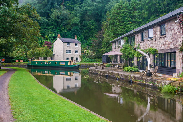
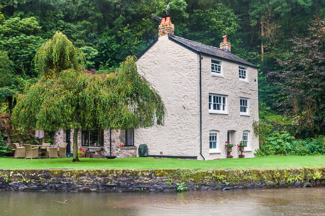
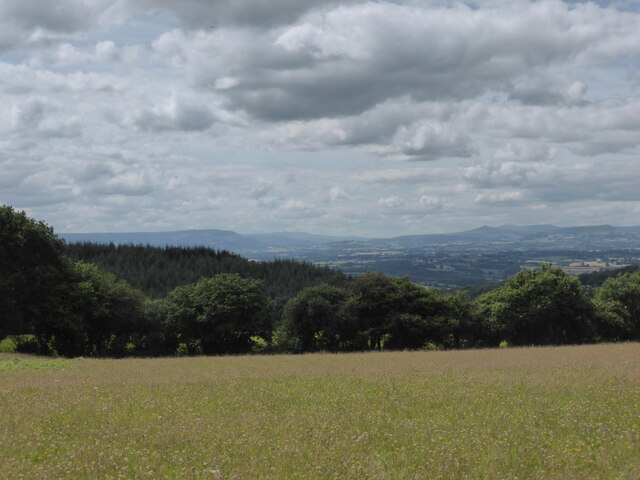
Gofilon is a small village located in Monmouthshire, Wales. Situated in the southeastern part of the country, it is nestled in the picturesque landscape of the Welsh countryside. The village is surrounded by rolling hills, lush green valleys, and meandering streams, offering residents and visitors a serene and idyllic setting.

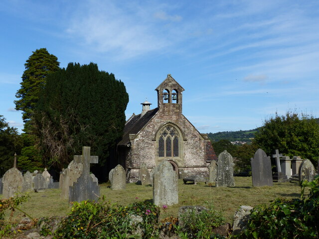
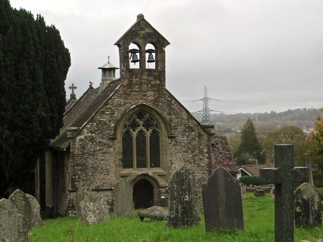
With a population of around 500 people, Gofilon is a close-knit community that exudes a friendly and welcoming atmosphere. The village boasts a rich history, with evidence of human settlement dating back to the Roman times. Its heritage can be seen in the well-preserved historic buildings that dot the village, including a charming church dating back to the 13th century.

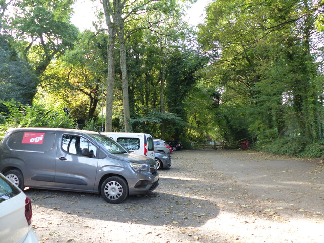
While Gofilon may be small in size, it is not lacking in amenities. The village is home to a local convenience store, a post office, and a cozy pub where locals often gather to socialize. Additionally, Gofilon benefits from its close proximity to larger towns and cities, with Monmouth just a short drive away, offering a wider range of services and facilities.

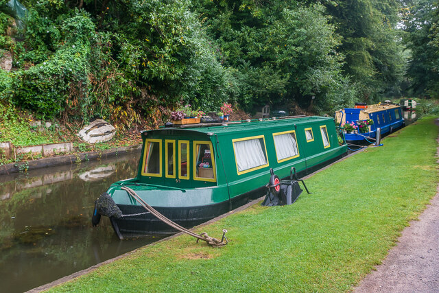
The natural surroundings of Gofilon provide ample opportunities for outdoor activities. The village is a popular starting point for hiking and walking trails, allowing visitors to explore the breathtaking countryside and enjoy the fresh air. The nearby River Wye also offers opportunities for fishing and canoeing, further adding to the recreational options available in the area.

Overall, Gofilon offers a tranquil and scenic escape, ideal for those seeking a peaceful retreat in the heart of the Welsh countryside.

If you have any feedback on the listing, please let us know in the comments section below.

Gofilon Images

Images are sourced within 2km of 51.815016/-3.062162 or Grid Reference SO2613. Thanks to Geograph Open Source API. All images are credited.

Llanfoist Wharf Wharf on the Monmouthshire and Brecon Canal at Llanfoist.  On the right is the Boathouse and in the background is Boathouse Cottage.  Both date from the early 19th Century, the former as a warehouse and the latter as a wharfinger's house, and both are grade II listed - see <span class="nowrap"><a title="http://cadwpublic-api.azurewebsites.net/reports/listedbuilding/FullReport?lang=en&id=2728" rel="nofollow ugc noopener" href="http://cadwpublic-api.azurewebsites.net/reports/listedbuilding/FullReport?lang=en&id=2728">Link</a><img style="margin-left:2px;" alt="External link" title="External link - shift click to open in new window" src="https://s1.geograph.org.uk/img/external.png" width="10" height="10"/></span> and <span class="nowrap"><a title="http://cadwpublic-api.azurewebsites.net/reports/listedbuilding/FullReport?lang=en&id=17235" rel="nofollow ugc noopener" href="http://cadwpublic-api.azurewebsites.net/reports/listedbuilding/FullReport?lang=en&id=17235">Link</a><img style="margin-left:2px;" alt="External link" title="External link - shift click to open in new window" src="https://s1.geograph.org.uk/img/external.png" width="10" height="10"/></span> respectively.
Llanfoist Wharf
Wharf on the Monmouthshire and Brecon Canal at Llanfoist. On the right is the Boathouse and in the background is Boathouse Cottage. Both date from the early 19th Century, the former as a warehouse and the latter as a wharfinger's house, and both are grade II listed - see LinkExternal link and LinkExternal link respectively.
Llanfoist Wharf Wharf on the Monmouthshire and Brecon Canal at Llanfoist, with Boathouse Cottage on its bank.  This dates from the early 19th Century and was built as a wharfinger's house.  It is grade II listed - see <span class="nowrap"><a title="http://cadwpublic-api.azurewebsites.net/reports/listedbuilding/FullReport?lang=en&id=17235" rel="nofollow ugc noopener" href="http://cadwpublic-api.azurewebsites.net/reports/listedbuilding/FullReport?lang=en&id=17235">Link</a><img style="margin-left:2px;" alt="External link" title="External link - shift click to open in new window" src="https://s1.geograph.org.uk/img/external.png" width="10" height="10"/></span>.
Llanfoist Wharf
Wharf on the Monmouthshire and Brecon Canal at Llanfoist, with Boathouse Cottage on its bank. This dates from the early 19th Century and was built as a wharfinger's house. It is grade II listed - see LinkExternal link.
Llanfoist Wharf Narrowboats moored at Llanfoist Wharf on the Monmouthshire and Brecon Canal.
Llanfoist Wharf
Narrowboats moored at Llanfoist Wharf on the Monmouthshire and Brecon Canal.
Church and graveyard in Llanfoist
Car park and cycleway at Llanfoist
Monmouthshire and Brecon canal near Llanfoist
Monmouthshire and Brecon canal heading south
St Faith's church, Llanfoist
Pedestrian tunnel under the canal Quite a spooky spot, as a freshwater stream pours through a channel here too.
Pedestrian tunnel under the canal
Quite a spooky spot, as a freshwater stream pours through a channel here too.
Stone stile into St Faith's churchyard
Llanwenarth Baptist Chapel, Govilon The rear of the chapel as viewed from the Monmouthshire and Brecon Canal.
This is the oldest surviving Baptist chapel in Wales dating from 1695 and part of the existing building dates back to that time.
 It was rebuilt in 1807, renovated in 1870, 1893 and the late 20th century.
 Grade II* Listed.
Llanwenarth Baptist Chapel, Govilon
The rear of the chapel as viewed from the Monmouthshire and Brecon Canal. This is the oldest surviving Baptist chapel in Wales dating from 1695 and part of the existing building dates back to that time. It was rebuilt in 1807, renovated in 1870, 1893 and the late 20th century. Grade II* Listed.
Rainbow above Cwm Llanwenarth Looking northwest from the B4246 Abergavenny Road out of Blaenavon, with the rainbow in front of the slopes of Gilwern Hill, above the valley known as Cwm Llanwenarth. Philbhu ref:P8140280a2
Rainbow above Cwm Llanwenarth
Looking northwest from the B4246 Abergavenny Road out of Blaenavon, with the rainbow in front of the slopes of Gilwern Hill, above the valley known as Cwm Llanwenarth. Philbhu ref:P8140280a2
Usk valley panorama Looking into Wales from a wildflower meadow west of the Wye valley

Blorenge - Brecon Beacons - Usk valley - Sugar Loaf - Black Mountains
Usk valley panorama
Looking into Wales from a wildflower meadow west of the Wye valley Blorenge - Brecon Beacons - Usk valley - Sugar Loaf - Black Mountains
Wharfinger's Cottage and tunnel under canal Wharfinger's Cottage was built after 1825 as the wharfinger's (i.e. wharfkeeper's) dwelling at Llanfoist Wharf on the Monmouthshire and Brecon Canal (originally the Brecknock and Abergavenny Canal).  The canal was built in 1812 and the wharf here developed in 1825 at the foot of the incline serving the tramroad from Garnddyrys Forge, built by Thomas Hill of Blaenavon that year.  The tunnel below the house dates from c.1812 when the canal was built and was extended when the house was added.  Both the building and tunnel are grade II listed - see <span class="nowrap"><a title="https://cadwpublic-api.azurewebsites.net/reports/listedbuilding/FullReport?lang=&id=17235" rel="nofollow ugc noopener" href="https://cadwpublic-api.azurewebsites.net/reports/listedbuilding/FullReport?lang=&id=17235">Link</a><img style="margin-left:2px;" alt="External link" title="External link - shift click to open in new window" src="https://s1.geograph.org.uk/img/external.png" width="10" height="10"/></span> and <span class="nowrap"><a title="https://cadwpublic-api.azurewebsites.net/reports/listedbuilding/FullReport?lang=&id=17237" rel="nofollow ugc noopener" href="https://cadwpublic-api.azurewebsites.net/reports/listedbuilding/FullReport?lang=&id=17237">Link</a><img style="margin-left:2px;" alt="External link" title="External link - shift click to open in new window" src="https://s1.geograph.org.uk/img/external.png" width="10" height="10"/></span> respectively.
Wharfinger's Cottage and tunnel under canal
Wharfinger's Cottage was built after 1825 as the wharfinger's (i.e. wharfkeeper's) dwelling at Llanfoist Wharf on the Monmouthshire and Brecon Canal (originally the Brecknock and Abergavenny Canal). The canal was built in 1812 and the wharf here developed in 1825 at the foot of the incline serving the tramroad from Garnddyrys Forge, built by Thomas Hill of Blaenavon that year. The tunnel below the house dates from c.1812 when the canal was built and was extended when the house was added. Both the building and tunnel are grade II listed - see LinkExternal link and LinkExternal link respectively.
Tunnel under canal Tunnel under the Monmouthshire and Brecon Canal (originally the Brecknock and Abergavenny Canal) at Llanfoist Wharf.  The canal was built in 1812 and the tunnel was built at the same time, pre-dating the wharf which was developed in 1825 at the foot of the incline serving the tramroad from Garnddyrys Forge, built by Thomas Hill of Blaenavon that year. Grade II listed - see <span class="nowrap"><a title="https://cadwpublic-api.azurewebsites.net/reports/listedbuilding/FullReport?lang=&id=17237" rel="nofollow ugc noopener" href="https://cadwpublic-api.azurewebsites.net/reports/listedbuilding/FullReport?lang=&id=17237">Link</a><img style="margin-left:2px;" alt="External link" title="External link - shift click to open in new window" src="https://s1.geograph.org.uk/img/external.png" width="10" height="10"/></span> respectively.
Tunnel under canal
Tunnel under the Monmouthshire and Brecon Canal (originally the Brecknock and Abergavenny Canal) at Llanfoist Wharf. The canal was built in 1812 and the tunnel was built at the same time, pre-dating the wharf which was developed in 1825 at the foot of the incline serving the tramroad from Garnddyrys Forge, built by Thomas Hill of Blaenavon that year. Grade II listed - see LinkExternal link respectively.
Former incline Path at Llanfoist Wharf on the Monmouthshire and Brecon Canal at the foot of the incline serving the tramroad from Garnddyrys Forge, built by Thomas Hill of Blaenavon in 1825.
Former incline
Path at Llanfoist Wharf on the Monmouthshire and Brecon Canal at the foot of the incline serving the tramroad from Garnddyrys Forge, built by Thomas Hill of Blaenavon in 1825.
Glanbaiden Access Road Side road leading to the small few homes in Glanbaiden. It was built during the early stages of the A465 widening. The small tunnel running under the A465 prior to widening was scrapped and a 5th exit was added to the new roundabout.
Glanbaiden Access Road
Side road leading to the small few homes in Glanbaiden. It was built during the early stages of the A465 widening. The small tunnel running under the A465 prior to widening was scrapped and a 5th exit was added to the new roundabout.
Show me another place!

Gofilon is located at Grid Ref: SO2613 (Lat: 51.815016, Lng: -3.062162)

Unitary Authority: Monmouthshire

Police Authority: Gwent

Also known as: Govilon

What 3 Words

///evoke.smoke.keen. Near Govilon, Monmouthshire

Related Wikis

Llanwenarth Baptist Chapel

Llanwenarth Baptist Chapel, Govilon, Monmouthshire is the oldest Baptist chapel in Wales. Founded in 1652, the present building was constructed in 1695...

Govilon

Govilon (Welsh: Gofilon) is a small Welsh village located between Llanfoist and Gilwern near Abergavenny in north Monmouthshire. It is part of the community...

Govilon railway station

Govilon railway station was a station on the London and North Western Railway's Heads of the Valleys line serving the village of Govilon in the Welsh county...

Llanwenarth Ultra

Llanwenarth Ultra is an electoral ward near Abergavenny, Monmouthshire. The ward elects councillors to Llanfoist Fawr Community Council and Monmouthshire...

Nearby Amenities

Located within 500m of 51.815016,-3.062162
Drinking Water
Access: customers
Fee: no
Lit: no
Man Made: water_tap
Operator: Canal and River Trust
Wheelchair: no
Lat/Long: 51.8173489/-3.0656989
Waterway: turning_point
Lat/Long: 51.8170267/-3.0593361
Traffic Calming: choker
Lat/Long: 51.8185821/-3.0653204
Bench
Ele: 103.0000000
Lat/Long: 51.8169429/-3.0596572
Crossing
Crossing: unmarked
Lat/Long: 51.8162395/-3.0661067
Barrier: kissing_gate
Lat/Long: 51.8174237/-3.0560139
Barrier: stile
Lat/Long: 51.81342/-3.0565251
Londis
Brand: Londis
Brand Wikidata: Q21008564
Shop: convenience
Lat/Long: 51.8186899/-3.0660158
Post Box
Post Box Type: lamp
Ref: NP7 104D
Royal Cypher: EIIR
Royal Cypher Wikidata: Q33102113
Lat/Long: 51.8159171/-3.0655191
Post Box
Operator: Royal Mail
Post Box Type: lamp
Lat/Long: 51.8186137/-3.0665293
Govilon
Historic Railway: station
Railway: site
Wikidata: Q18737071
Lat/Long: 51.8160802/-3.067089
Crossing
Lat/Long: 51.8173991/-3.0664569
Direction: WSW
Generator Method: photovoltaic
Generator Output Electricity: yes
Generator Solar Modules: 16
Generator Source: solar
Generator Type: solar_photovoltaic_panel
Location: roof
Power: generator
Lat/Long: 51.8160785/-3.0691499
Direction: 165
Generator Method: photovoltaic
Generator Output Electricity: yes
Generator Solar Modules: 16
Generator Source: solar
Generator Type: solar_photovoltaic_panel
Location: roof
Power: generator
Lat/Long: 51.814893/-3.0693886
Direction: 175
Generator Method: photovoltaic
Generator Output Electricity: yes
Generator Solar Modules: 16
Generator Source: solar
Generator Type: solar_photovoltaic_panel
Location: roof
Power: generator
Lat/Long: 51.8165677/-3.0654645
Direction: 175
Generator Method: photovoltaic
Generator Output Electricity: yes
Generator Solar Modules: 16
Generator Source: solar
Generator Type: solar_photovoltaic_panel
Location: roof
Power: generator
Lat/Long: 51.8165254/-3.065667
Direction: SSE
Generator Method: photovoltaic
Generator Output Electricity: yes
Generator Solar Modules: 12
Generator Source: solar
Generator Type: solar_photovoltaic_panel
Location: roof
Power: generator
Lat/Long: 51.8164657/-3.0658695
Direction: 190
Generator Method: photovoltaic
Generator Output Electricity: yes
Generator Solar Modules: 8
Generator Source: solar
Generator Type: solar_photovoltaic_panel
Location: roof
Power: generator
Lat/Long: 51.8156201/-3.0628225
Direction: 190
Generator Method: photovoltaic
Generator Output Electricity: yes
Generator Solar Modules: 6
Generator Source: solar
Generator Type: solar_photovoltaic_panel
Location: roof
Power: generator
Lat/Long: 51.8187536/-3.0658973
Direction: 190
Generator Method: photovoltaic
Generator Output Electricity: yes
Generator Solar Modules: 6
Generator Source: solar
Generator Type: solar_photovoltaic_panel
Location: roof
Power: generator
Lat/Long: 51.8187441/-3.0658125
Direction: 175
Generator Method: photovoltaic
Generator Output Electricity: yes
Generator Solar Modules: 7
Generator Source: solar
Generator Type: solar_photovoltaic_panel
Location: roof
Power: generator
Lat/Long: 51.8186261/-3.0633388
Direction: 170
Generator Method: photovoltaic
Generator Output Electricity: yes
Generator Solar Modules: 14
Generator Source: solar
Generator Type: solar_photovoltaic_panel
Location: roof
Power: generator
Lat/Long: 51.8178104/-3.0638136
Waterway: water_point
Lat/Long: 51.8170297/-3.0583035
Parking
Fee: no
Parking: surface
Lat/Long: 51.8173311/-3.0574243
Board Type: history
Information: board
Tourism: information
Lat/Long: 51.8173771/-3.0664037
Bench
Colour: black
Material: composite
Seats: 4
Lat/Long: 51.818639/-3.06456
Shelter
Bench: yes
Bin: yes
Shelter Type: public_transport
Lat/Long: 51.8186389/-3.0644751
The data included in this document is from www.openstreetmap.org. The data is made available under ODbL.

Have you been to Gofilon?

Leave your review of Gofilon below (or comments, questions and feedback).