Aylestone

Settlement in Leicestershire

England

Aylestone

Great Central Way, Glen Parva Looking towards Leicester city centre from its junction with a path from Parsons Drive.
Great Central Way, Glen Parva Credit: Richard Vince

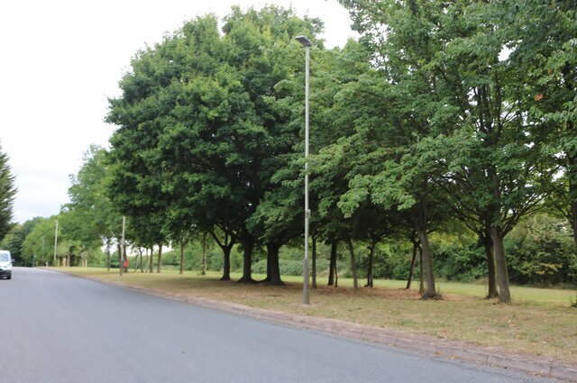
Aylestone is a suburb located in the city of Leicester, within the county of Leicestershire, England. Situated on the outskirts of the city, Aylestone is a predominantly residential area known for its peaceful atmosphere and green surroundings.

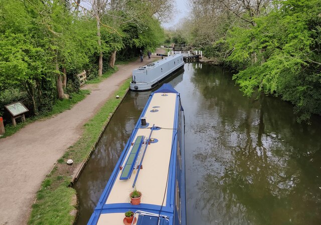
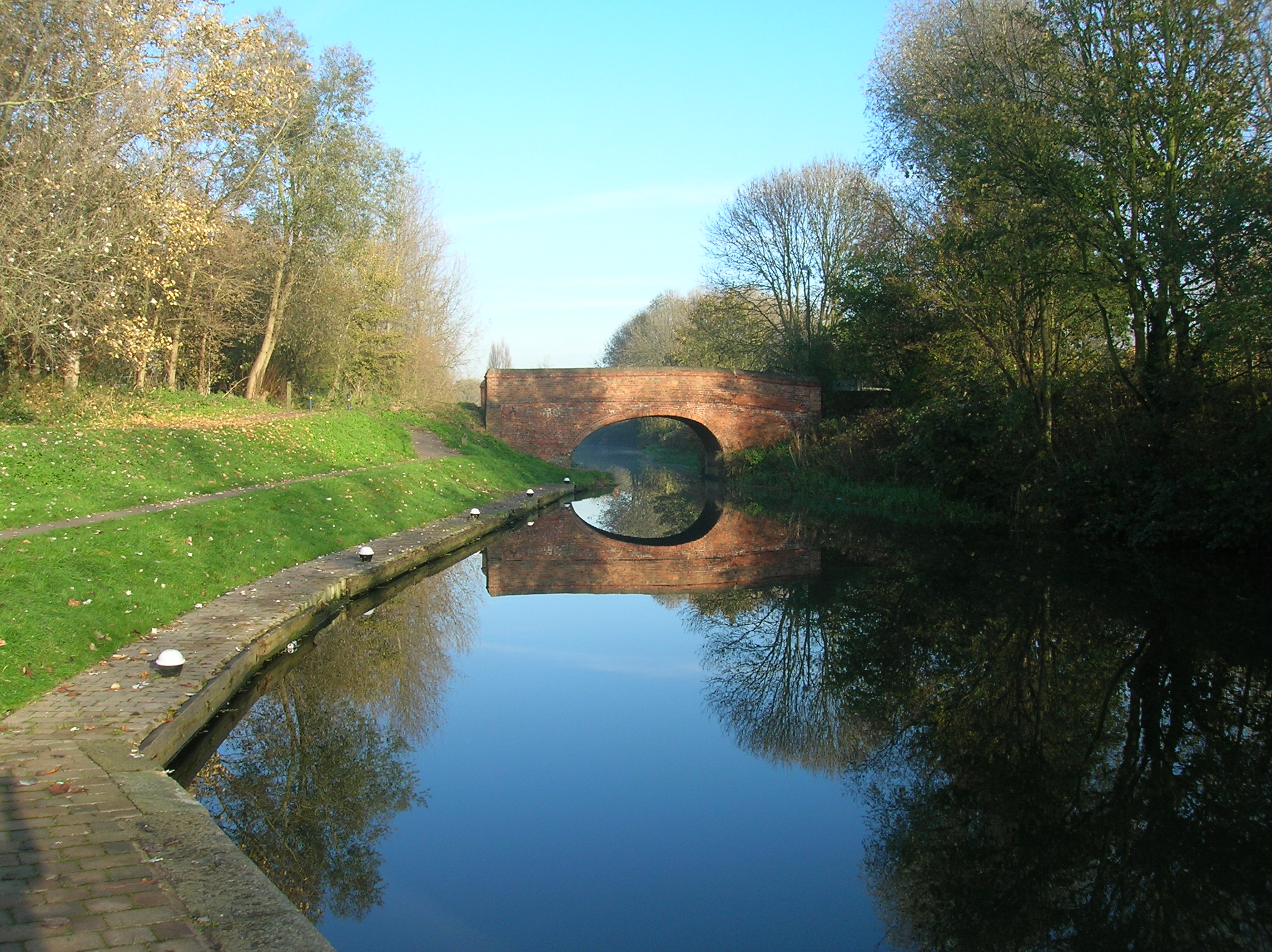
The suburb is bordered by the Grand Union Canal to the west, adding to its charm and providing opportunities for scenic walks and leisure activities. Aylestone's history dates back to Roman times, with evidence of Roman settlements found in the area.

Aylestone offers a range of amenities to its residents, including local shops, supermarkets, and restaurants. The community is served by several schools, making it an attractive area for families. The suburb also benefits from good transportation links, with regular bus services connecting it to Leicester city center and other nearby areas.

One of the key attractions in Aylestone is Aylestone Hall, a historic building that dates back to the 17th century. This Grade II listed mansion is surrounded by beautiful landscaped gardens and is often used as a venue for weddings, conferences, and other events.

Nature lovers will appreciate Aylestone Meadows, a large open space located along the River Soar. This nature reserve offers picturesque views, wildlife spotting opportunities, and a peaceful environment for walks and picnics.

Overall, Aylestone is a delightful suburb that combines the tranquility of suburban living with easy access to the amenities and attractions of Leicester city center.

If you have any feedback on the listing, please let us know in the comments section below.

Aylestone Images

Images are sourced within 2km of 52.60404/-1.159038 or Grid Reference SK5701. Thanks to Geograph Open Source API. All images are credited.

Great Central Way, Glen Parva Looking towards Leicester city centre from its junction with a path from Parsons Drive.
Great Central Way, Glen Parva
Looking towards Leicester city centre from its junction with a path from Parsons Drive.
Middleton Street in Aylestone, Leicester Aylestone is a suburb of Leicester, about 2½ miles southwest of Leicester city centre.
The flooding was caused by Storm Henk, which hit the previous day on 2 January 2024.
Middleton Street in Aylestone, Leicester
Aylestone is a suburb of Leicester, about 2½ miles southwest of Leicester city centre. The flooding was caused by Storm Henk, which hit the previous day on 2 January 2024.
Flooding on the River Soar in Aylestone, Leicester Aylestone is a suburb of Leicester, about 2½ miles southwest of Leicester city centre.
The flooding was caused by Storm Henk, which hit the previous day on 2 January 2024.
Flooding on the River Soar in Aylestone, Leicester
Aylestone is a suburb of Leicester, about 2½ miles southwest of Leicester city centre. The flooding was caused by Storm Henk, which hit the previous day on 2 January 2024.
Flooding on the River Soar at Aylestone, Leicester Aylestone is a suburb of Leicester, about 2½ miles southwest of Leicester city centre.
The flooding was caused by Storm Henk, which hit the previous day on 2 January 2024.
Flooding on the River Soar at Aylestone, Leicester
Aylestone is a suburb of Leicester, about 2½ miles southwest of Leicester city centre. The flooding was caused by Storm Henk, which hit the previous day on 2 January 2024.
Flooding on Braunstone Lane East The bridge carries the Great Central Way cycleway and footpath across the lane.
The flooding was caused by Storm Henk, which hit the previous day on 2 January 2024.
Flooding on Braunstone Lane East
The bridge carries the Great Central Way cycleway and footpath across the lane. The flooding was caused by Storm Henk, which hit the previous day on 2 January 2024.
Flooding next to Braunstone Lane East The flooding was caused by Storm Henk, which hit the previous day on 2 January 2024.
Flooding next to Braunstone Lane East
The flooding was caused by Storm Henk, which hit the previous day on 2 January 2024.
Flooding on the River Soar at Aylestone, Leicester Aylestone is a suburb of Leicester, about 2½ miles southwest of Leicester city centre.
The flooding was caused by Storm Henk, which hit the previous day on 2 January 2024.
Flooding on the River Soar at Aylestone, Leicester
Aylestone is a suburb of Leicester, about 2½ miles southwest of Leicester city centre. The flooding was caused by Storm Henk, which hit the previous day on 2 January 2024.
Flooding in Aylestone Aylestone is a suburb of Leicester, about 2½ miles southwest of Leicester city centre.
The flooding was caused by Storm Henk, which hit the previous day on 2 January 2024. The flooding is at the junction of Marsden Lane and Sanvey Lane.
Flooding in Aylestone
Aylestone is a suburb of Leicester, about 2½ miles southwest of Leicester city centre. The flooding was caused by Storm Henk, which hit the previous day on 2 January 2024. The flooding is at the junction of Marsden Lane and Sanvey Lane.
Frozen pond on the Aylestone Meadows The Aylestone Meadows is the largest nature reserve in the city of Leicester, it is situated on the floodplains of the River Soar and River Biam.
Frozen pond on the Aylestone Meadows
The Aylestone Meadows is the largest nature reserve in the city of Leicester, it is situated on the floodplains of the River Soar and River Biam.
Tesla charging station at Fosse Park West
Everards brewery and beer hall Opened in June 2021.
Everards brewery and beer hall
Opened in June 2021.
Church of St Hugh of Lincoln, Eyres Monsell, Leicester "Built 1955-58, an excellent representative of a mid-20th century parish church designed by the practice of the nationally recognised architect Sir Basil Spence." [Local Heritage Asset Register, Leicester city Council]. This is an 'Anglo Catholic' church <span class="nowrap"><a title="https://sthugheyresmonsell.org.uk/" rel="nofollow ugc noopener" href="https://sthugheyresmonsell.org.uk/">Link</a><img style="margin-left:2px;" alt="External link" title="External link - shift click to open in new window" src="https://s1.geograph.org.uk/img/external.png" width="10" height="10"/></span> within the Church of England.
Church of St Hugh of Lincoln, Eyres Monsell, Leicester
"Built 1955-58, an excellent representative of a mid-20th century parish church designed by the practice of the nationally recognised architect Sir Basil Spence." [Local Heritage Asset Register, Leicester city Council]. This is an 'Anglo Catholic' church LinkExternal link within the Church of England.
Narrowboats at Blue Bank Lock No 37 The Leicester section branches off the main line at Braunston and it is 66 miles long with 59 locks (including two five chamber staircase locks at Foxton) and two tunnels. Near Leicester it continues into the River Soar, and briefly along the River Wreake. The navigation then proceeds along the river, with some canalised diversions, to Loughborough and the River Trent south of Long Eaton.
Narrowboats at Blue Bank Lock No 37
The Leicester section branches off the main line at Braunston and it is 66 miles long with 59 locks (including two five chamber staircase locks at Foxton) and two tunnels. Near Leicester it continues into the River Soar, and briefly along the River Wreake. The navigation then proceeds along the river, with some canalised diversions, to Loughborough and the River Trent south of Long Eaton.
Leicester Road, Glen Parva
Gilmorton Avenue, Glen Parva
Houses on Gilmorton Avenue, Glen Parva
Gilmorton Avenue, Glen Parva The park is along the Grand Union Canal.
Gilmorton Avenue, Glen Parva
The park is along the Grand Union Canal.
Gilmorton Avenue, Glen Parva The little sign on the house on the right says "Beware of the dogs 24/7 CCTV recording. Friendly people.
Gilmorton Avenue, Glen Parva
The little sign on the house on the right says "Beware of the dogs 24/7 CCTV recording. Friendly people.
Show me another place!

Aylestone is located at Grid Ref: SK5701 (Lat: 52.60404, Lng: -1.159038)

Unitary Authority: Leicester

Police Authority: Leicestershire

What 3 Words

///fake.rapid.maple. Near Blaby, Leicestershire

Nearby Locations

Aylestone

Related Wikis

Aylestone Meadows

Aylestone Meadows is an 8.8-hectare (22-acre) Local Nature Reserve in Leicester, England, United Kingdom. It is owned and managed by Leicester City Council...

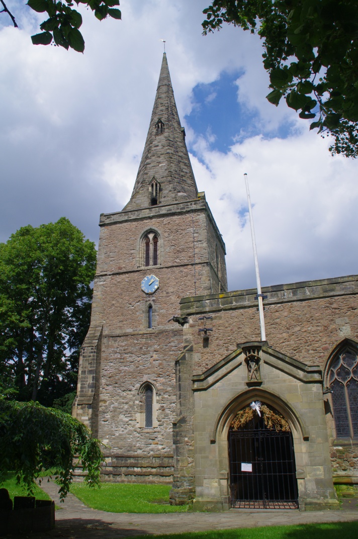
St Andrew's Church, Aylestone

St Andrew's Church is a church in Aylestone, Leicestershire. It is a Grade II* listed building. == History == The church is built of Triassic sandstone...

Aylestone

Aylestone is a suburb of Leicester, in the ceremonial county of Leicestershire, England, southwest of the city centre and to the east of the River Soar...

Leicester St Andrews F.C.

Leicester St Andrews Football Club are a football club based in Aylestone, a suburb of Leicester, England. They play in the United Counties League Division...

Nearby Amenities

Located within 500m of 52.60404,-1.159038
Traffic Signals
Lat/Long: 52.6021364/-1.155891
Maxheight: 4.5
Lat/Long: 52.6051395/-1.1602839
Baz's Barbers
Addr City: Leicester
Addr Housenumber: 727
Addr Postcode: LE2 8TG
Addr Street: Aylestone Road
Ref: LE2 132
Shop: hairdresser
Lat/Long: 52.6029482/-1.1548684
Barrier: bollard
Lat/Long: 52.6074002/-1.1543678
Crossing
Crossing Ref: zebra
Lat/Long: 52.6037658/-1.1575851
Power: tower
Lat/Long: 52.6039858/-1.1628637
Power: tower
Lat/Long: 52.6075986/-1.1582476
Power: tower
Lat/Long: 52.6052921/-1.1596799
Power: tower
Source: Bing
Lat/Long: 52.6078528/-1.1621692
Power: tower
Source: Bing
Lat/Long: 52.6061132/-1.1651733
Power: tower
Source: Bing
Lat/Long: 52.6072927/-1.1594674
Power: tower
Source: Bing
Lat/Long: 52.6033776/-1.1652996
Power: tower
Source: Bing
Lat/Long: 52.605157/-1.1610301
Seamark Type: gate
Waterway: lock_gate
Lat/Long: 52.6015322/-1.1644246
Seamark Type: gate
Source: Bing
Waterway: lock_gate
Lat/Long: 52.6017138/-1.1641349
Barrier: bollard
Lat/Long: 52.6072814/-1.154581
Pub
The Black Horse
Website: https://www.blackhorseaylestone.co.uk/
Lat/Long: 52.6029817/-1.1596764
Tesco Express
Brand: Tesco Express
Brand Wikidata: Q98456772
Contact Website: https://www.tesco.com/store-locator/leicester/9-13-lutterworth-rd
Shop: convenience
Lat/Long: 52.6022105/-1.1564316
Graham Goode Motors
Shop: car_repair
Lat/Long: 52.6021056/-1.1566856
Crossing
Crossing: unmarked
Lat/Long: 52.6047474/-1.1596369
Generator Method: photovoltaic
Generator Output Electricity: yes
Generator Source: solar
Generator Type: solar_photovoltaic_panel
Location: roof
Power: generator
Lat/Long: 52.5999303/-1.1560674
Generator Method: photovoltaic
Generator Output Electricity: yes
Generator Source: solar
Generator Type: solar_photovoltaic_panel
Location: roof
Power: generator
Lat/Long: 52.5999564/-1.1561613
Generator Method: photovoltaic
Generator Output Electricity: yes
Generator Source: solar
Generator Type: solar_photovoltaic_panel
Location: roof
Power: generator
Lat/Long: 52.6041352/-1.1587688
Generator Method: photovoltaic
Generator Output Electricity: yes
Generator Source: solar
Generator Type: solar_photovoltaic_panel
Location: roof
Power: generator
Lat/Long: 52.6041727/-1.158919
Generator Method: photovoltaic
Generator Output Electricity: yes
Generator Source: solar
Generator Type: solar_photovoltaic_panel
Location: roof
Power: generator
Lat/Long: 52.6023286/-1.1594179
Generator Method: photovoltaic
Generator Output Electricity: yes
Generator Source: solar
Generator Type: solar_photovoltaic_panel
Location: roof
Power: generator
Lat/Long: 52.6010417/-1.1552525
Generator Method: photovoltaic
Generator Output Electricity: yes
Generator Source: solar
Generator Type: solar_photovoltaic_panel
Location: roof
Power: generator
Lat/Long: 52.6014701/-1.1562851
Fast Food
Fung Tao
Addr City: Leicester
Addr Housenumber: 719
Addr Postcode: LE2 8TG
Addr Street: Aylestone Road
Cuisine: chinese
Lat/Long: 52.6031138/-1.1546696
Beautique
Addr City: Leicester
Addr Housenumber: 721
Addr Postcode: LE2 8TG
Addr Street: Aylestone Road
Note: "Hairdresser & Beauty"
Shop: hairdresser
Lat/Long: 52.6030751/-1.1547195
Restaurant
Aylestone Spice
Addr City: Leicester
Addr Housenumber: 723
Addr Postcode: LE2 8TG
Addr Street: Aylestone Road
Cuisine: indian
Lat/Long: 52.6030335/-1.1547611
Guy's Barbers
Addr City: Leicester
Addr Housenumber: 725
Addr Postcode: LE2 8TG
Addr Street: Aylestone Road
Shop: hairdresser
Lat/Long: 52.6029899/-1.1548067
Saby Nails & Beauty
Addr City: Leicester
Addr Housenumber: 1
Addr Postcode: LE2 8LH
Addr Street: Earl Russell Street
Beauty: nails
Shop: beauty
Lat/Long: 52.6029248/-1.1549401
Bar
The Lounge Bar
Addr City: Leicester
Addr Housenumber: 731
Addr Postcode: LE2 8TG
Addr Street: Aylestone Road
Brewery: no
Lat/Long: 52.6026337/-1.1552907
Coin-Op Launderette
Addr City: Leicester
Addr Housenumber: 735
Addr Postcode: LE2 8TG
Addr Street: Aylestone Road
Self Service: yes
Shop: laundry
Lat/Long: 52.6026066/-1.1553493
Fast Food
Bodrum Turkish BBQ
Addr City: Leicester
Addr Housenumber: 737
Addr Postcode: LE2 8TG
Addr Street: Aylestone Road
Cuisine: kebab
Lat/Long: 52.6025663/-1.1553986
Fast Food
George's Pizza
Addr City: Leicester
Addr Housenumber: 745
Addr Postcode: LE2 8TG
Addr Street: Aylestone Road
Cuisine: pizza
Note: Does burgers, kebabs & curry too
Lat/Long: 52.6025065/-1.1554787
Euro Market (U Grubego)
Addr City: Leicester
Addr Housenumber: 747
Addr Postcode: LE2 8TG
Addr Street: Aylestone Road
Shop: supermarket
Lat/Long: 52.6024775/-1.1555187
Empty - another Vanity shop?
Description: It's believed locally that this will be yet another vanity shop when it's finally finished.
Disused Shop: yes
Lat/Long: 52.6024204/-1.1556219
Old Aylestone Social Club
Addr City: Leicester
Addr Housenumber: 1
Addr Postcode: LE2 8LU
Addr Street: Middleton Street
Club: yes
Operator: Old Aylestone Social Club
Lat/Long: 52.6022792/-1.1559682
Milners Bakery
Addr City: Leicester
Addr Housenumber: 650
Addr Postcode: LE2 8PR
Addr Street: Aylestone Road
Shop: bakery
Lat/Long: 52.6029396/-1.1545018
Cafe
Addr City: Leicester
Addr Housenumber: 652
Addr Postcode: LE2 8PR
Addr Street: Aylestone Road
Lat/Long: 52.6029038/-1.1545679
Fast Food
Piccadilly
Addr City: Leicester
Addr Housenumber: 2
Addr Postcode: LE2 8PE
Addr Street: Lutterworth Road
Cuisine: kebab;pizza;burger
Lat/Long: 52.602256/-1.1553308
The Fitting Room
Addr City: Leicester
Addr Housenumber: 4
Addr Postcode: LE2 8PE
Addr Street: Lutterworth Road
Clothes: wedding
Shop: clothes
Lat/Long: 52.6022218/-1.1553751
Fast Food
The Ocean
Addr City: Leicester
Addr Housenumber: 4A
Addr Postcode: LE2 8PE
Addr Street: Lutterworth Road
Cuisine: fish_and_chips;burger;kebab
Lat/Long: 52.6021583/-1.1554542
Fast Food
Curry Junction
Addr City: Leicester
Addr Housenumber: 6
Addr Postcode: LE2 8PE
Addr Street: Lutterworth Road
Lat/Long: 52.6021265/-1.1555039
Fast Food
Jade Garden
Addr City: Leicester
Addr Housenumber: 6A
Addr Postcode: LE2 8PE
Addr Street: Lutterworth Road
Cuisine: chinese
Lat/Long: 52.602098/-1.1555441
Rayners
Addr City: Leicester
Addr Postcode: LE2 8PE
Addr Street: Aylestone Road
Shop: hairdresser
Lat/Long: 52.6020467/-1.1556487
A&J MOT & Auto Repairs
Addr City: Leicester
Addr Housenumber: 10
Addr Postcode: LE2 8PE
Addr Street: Lutterworth Road
Shop: car_repair
Lat/Long: 52.6020011/-1.1556903
Crossing
Crossing: traffic_signals
Crossing Island: no
Tactile Paving: yes
Lat/Long: 52.6035093/-1.1539323
Give Way
Direction: backward
Lat/Long: 52.6023097/-1.1607799
The data included in this document is from www.openstreetmap.org. The data is made available under ODbL.

Have you been to Aylestone?

Leave your review of Aylestone below (or comments, questions and feedback).