Kirriereoch Loch

Lake, Pool, Pond, Freshwater Marsh in Kirkcudbrightshire

Scotland

Kirriereoch Loch

Natural ice sculpture, Loch Moan A cold North wind was blowing spray from the loch on to grasses on the shore, resulting in fantastic ice shapes.
Natural ice sculpture, Loch Moan Credit: Alan Reid

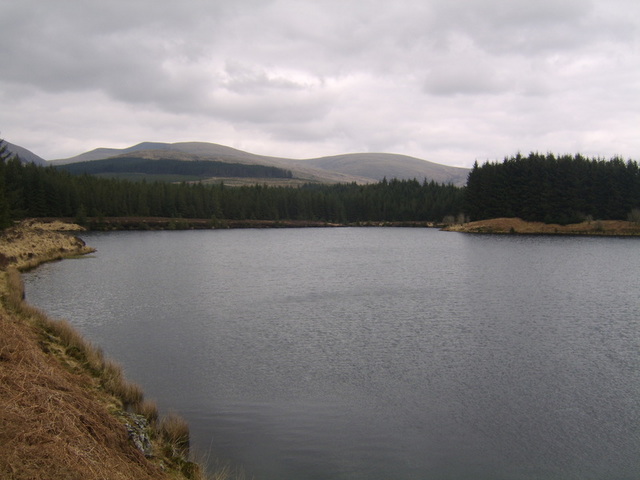
Kirriereoch Loch is a picturesque freshwater loch located in Kirkcudbrightshire, Scotland. Nestled amidst the stunning landscape of the Galloway Forest Park, the loch spans approximately 1.5 kilometers in length and covers an area of about 36 hectares. Surrounded by rolling hills and dense forests, the loch attracts visitors with its serene and tranquil ambiance.

The loch itself is known for its crystal-clear waters, which are fed by several small streams and springs that flow into the loch from the surrounding hills. This makes it an ideal habitat for a variety of aquatic plants and wildlife. The loch is home to an array of fish species, including brown trout, which makes it a popular spot for anglers seeking a peaceful day of fishing.

The surrounding area of Kirriereoch Loch is a haven for nature enthusiasts and birdwatchers. The loch is surrounded by a freshwater marsh, which provides a habitat for various water-loving plants and animals, including reeds, sedges, and waterfowl such as ducks and geese. The marshland also attracts a diverse range of bird species, including swans, herons, and even ospreys, making it a paradise for birdwatchers.

Access to Kirriereoch Loch is relatively easy, with a small car park and a walking trail that encircles the loch, allowing visitors to explore its beauty at their own pace. The tranquil atmosphere, combined with the breathtaking natural surroundings, makes Kirriereoch Loch a popular destination for those seeking a peaceful retreat in the heart of Kirkcudbrightshire.

If you have any feedback on the listing, please let us know in the comments section below.

Kirriereoch Loch Images

Images are sourced within 2km of 55.146586/-4.5674583 or Grid Reference NX3686. Thanks to Geograph Open Source API. All images are credited.

Natural ice sculpture, Loch Moan A cold North wind was blowing spray from the loch on to grasses on the shore, resulting in fantastic ice shapes.
Natural ice sculpture, Loch Moan
A cold North wind was blowing spray from the loch on to grasses on the shore, resulting in fantastic ice shapes.
Entering Dumfries and Galloway
The Water of Minnoch In Scotland, there are orders of magnitude for water courses: a 'water' is larger than a stream or burn but smaller than a river. (After prolonged heavy rain it can be hard to tell the difference!)
The Water of Minnoch
In Scotland, there are orders of magnitude for water courses: a 'water' is larger than a stream or burn but smaller than a river. (After prolonged heavy rain it can be hard to tell the difference!)
Sheep, lochan, forest, hills Looking towards the Rig of Shalloch
Sheep, lochan, forest, hills
Looking towards the Rig of Shalloch
Kirriereoch Loch and Galloway Hills
At the water's edge Kirriereoch Loch, Galloway
At the water's edge
Kirriereoch Loch, Galloway
Bracken, stile and Geographer At Kirriereoch Loch. This ladder stile is little used, poorly maintained and precarious, even though the area is licensed for fishing.
Bracken, stile and Geographer
At Kirriereoch Loch. This ladder stile is little used, poorly maintained and precarious, even though the area is licensed for fishing.
Bog and forestry The Range of the Awful Hand: Tarfessoch, Kirriereoch and other western Galloway Hills form its fingers but the reality is less fearsome than its name. However, you do have to contend with miles of (awfully tedious) forestry roads before even getting to climb the hills themselves.
Bog and forestry
The Range of the Awful Hand: Tarfessoch, Kirriereoch and other western Galloway Hills form its fingers but the reality is less fearsome than its name. However, you do have to contend with miles of (awfully tedious) forestry roads before even getting to climb the hills themselves.
Picnic site Kirriereoch
Picnic site
Kirriereoch
Northern shore Kirriereoch Loch
Northern shore
Kirriereoch Loch
Difficult terrain Much of the forestry shown here on the O/S map is no longer. This felled area is treacherous for walking with loose branches overlaying bog and water-logged trenches.
Difficult terrain
Much of the forestry shown here on the O/S map is no longer. This felled area is treacherous for walking with loose branches overlaying bog and water-logged trenches.
Un-mapped footbridge Kirriereoch Loch
Un-mapped footbridge
Kirriereoch Loch
Two lochs Kirriereoch (nearer) and Moan (further) from Tarfessock.
Two lochs
Kirriereoch (nearer) and Moan (further) from Tarfessock.
The Pillow Burn Crossed by the forest road.
The Pillow Burn
Crossed by the forest road.
Welcome to Dumfries & Galloway
The Road to Straiton
Moors of Cairnfore Hill pre-afforestation
Southwest from Cairnfore Hill Knockdolian is the hill on the horizon.
Southwest from Cairnfore Hill
Knockdolian is the hill on the horizon.
Show me another place!

Kirriereoch Loch is located at Grid Ref: NX3686 (Lat: 55.146586, Lng: -4.5674583)

Unitary Authority: Dumfries and Galloway

Police Authority: Dumfries and Galloway

What 3 Words

///squeezed.seasonal.lengthen. Near Girvan, South Ayrshire

Related Wikis

Kirriereoch Loch

Kirriereoch Loch is a small, shallow, square shaped, freshwater loch in Dumfries and Galloway, in the Southern Uplands of south-west Scotland. It lies...

Shalloch on Minnoch

Shalloch on Minnoch is a hill in the Range of the Awful Hand, a sub-range of the Galloway Hills range, part of the Southern Uplands of Scotland. It is...
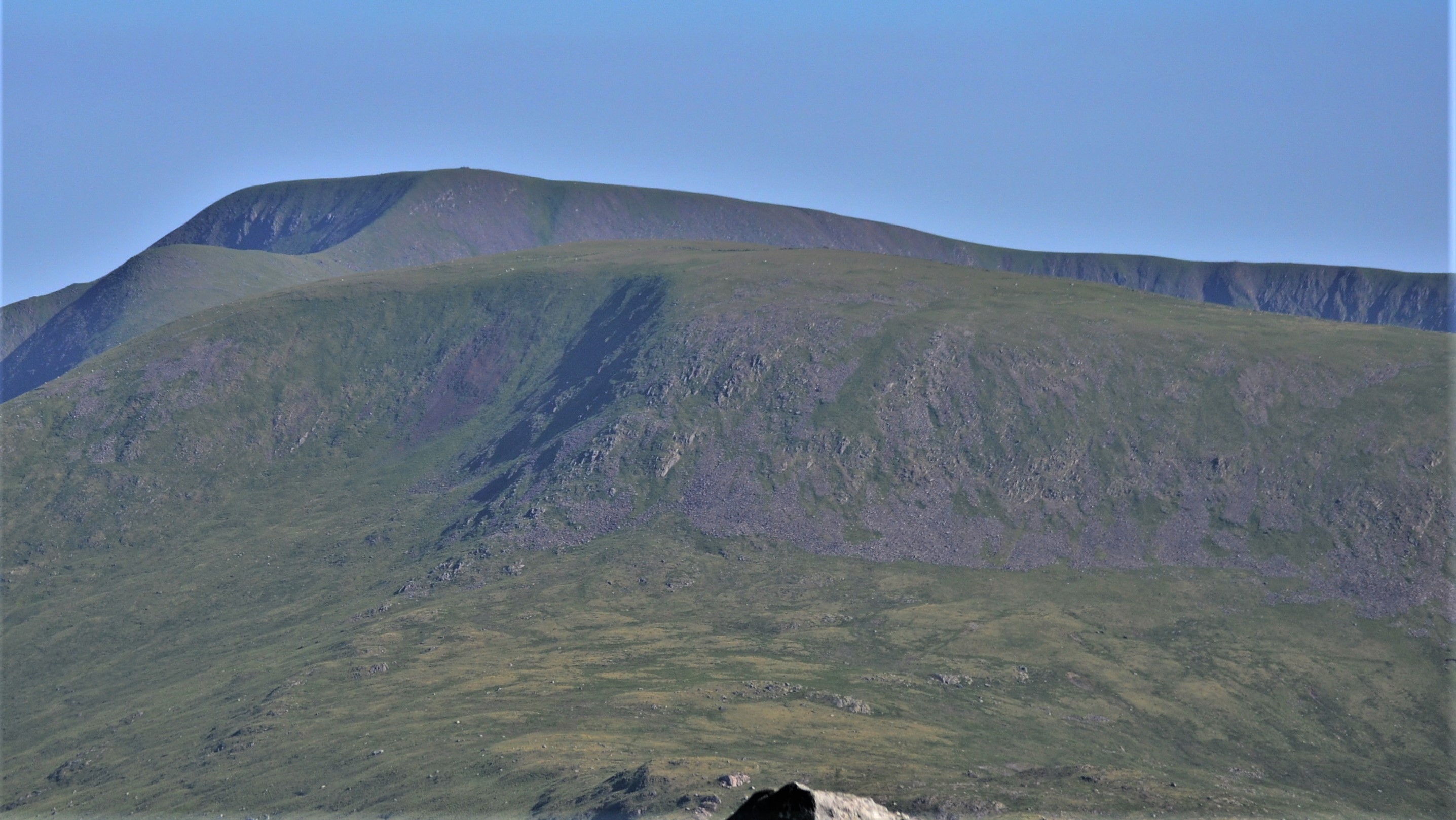
Kirriereoch Hill

Kirriereoch Hill is a hill in the Range of the Awful Hand, a sub-range of the Galloway Hills range, part of the Southern Uplands of Scotland. It lies on...

Merrick (Galloway)

The Merrick, or simply Merrick (Scottish Gaelic: A' Mhearag), is a mountain in the Range of the Awful Hand, a sub-range of the Galloway Hills range, part...

Nearby Amenities

Located within 500m of 55.146586,-4.5674583
Power: pole
Lat/Long: 55.1501993/-4.5718753
The data included in this document is from www.openstreetmap.org. The data is made available under ODbL.

Have you been to Kirriereoch Loch?

Leave your review of Kirriereoch Loch below (or comments, questions and feedback).