Loch of Reiff

Lake, Pool, Pond, Freshwater Marsh in Cromartyshire

Scotland

Loch of Reiff

Rocks on the west side of Rubha Mor Shown at about half tide, quite menacing in a blow when mostly covered at high tide, with a very deep water drop off just off the edge of them. Good for pollack though!
Rocks on the west side of Rubha Mor Credit: Simon Bonney

Loch of Reiff, located in Cromartyshire, is a picturesque freshwater loch nestled amidst the stunning Scottish Highlands. Spanning across an area of approximately 2 square kilometers, it is a popular attraction for nature enthusiasts and visitors seeking tranquility.

Surrounded by rolling hills and rocky cliffs, Loch of Reiff offers breathtaking views of its crystal-clear waters. The loch is fed by several small streams that flow down from the surrounding hills, ensuring a constant supply of freshwater. The water is relatively shallow, with an average depth of around 5 meters, making it an ideal habitat for various aquatic plants and animals.

The loch is also home to an array of wildlife, including a diverse range of bird species. Birdwatchers often flock to Loch of Reiff to catch a glimpse of rare species such as golden eagles, ospreys, and red-throated divers. The surrounding marshy areas provide a suitable nesting ground for waterfowl, creating a vibrant and lively ecosystem.

Visitors to Loch of Reiff can explore the area by foot, with several hiking trails offering stunning views of the loch and its surroundings. The rocky cliffs surrounding the loch also offer opportunities for rock climbing and abseiling, attracting adventure seekers from far and wide.

Overall, Loch of Reiff is a hidden gem in Cromartyshire, offering a tranquil and picturesque setting for nature lovers to immerse themselves in the beauty of the Scottish Highlands.

If you have any feedback on the listing, please let us know in the comments section below.

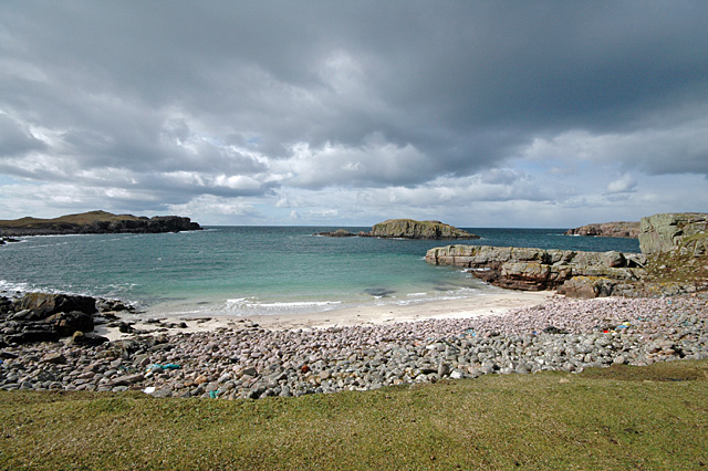
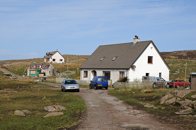
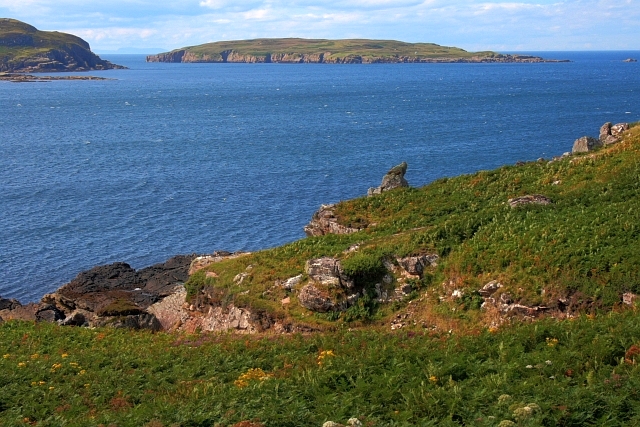
Loch of Reiff Images

Images are sourced within 2km of 58.074366/-5.4523024 or Grid Reference NB9614. Thanks to Geograph Open Source API. All images are credited.

Rocks on the west side of Rubha Mor Shown at about half tide, quite menacing in a blow when mostly covered at high tide, with a very deep water drop off just off the edge of them. Good for pollack though!
Rocks on the west side of Rubha Mor
Shown at about half tide, quite menacing in a blow when mostly covered at high tide, with a very deep water drop off just off the edge of them. Good for pollack though!
Reiff The very end of the road!
Reiff
The very end of the road!
Camas Eilean Ghlais - Rubha Mor Beach at Camas Eilean Ghlais on Rubha Mor with Eilean Glas.
Camas Eilean Ghlais - Rubha Mor
Beach at Camas Eilean Ghlais on Rubha Mor with Eilean Glas.
Coastline near Reiff
Coastline Rubha Mor
Coastline Rubha Mor
Reiff jetty High tide and high winds combine almost to drown this little-used jetty at the end of the road on the Coigach Peninsula.
Reiff jetty
High tide and high winds combine almost to drown this little-used jetty at the end of the road on the Coigach Peninsula.
The Reiff road Looking in the direction of Altandhu, where the smokehouse fragrances the air. Across the water is Isle Ristol.
The Reiff road
Looking in the direction of Altandhu, where the smokehouse fragrances the air. Across the water is Isle Ristol.
Fishing near Reiff Caught nothing but Sasha found a Ball
Fishing near Reiff
Caught nothing but Sasha found a Ball
Houses at Blairbuie
Houses at Blairbuie
Reiff Loch Reiff in foreground
Reiff
Loch Reiff in foreground
Geodha an Dà Fheannag Looking across Geodha an Dà Fheannag and Geodha an Glaic Bàine towards Reiff Bay. In the foreground is an outcrop of Torridean sandstone.
Geodha an Dà Fheannag
Looking across Geodha an Dà Fheannag and Geodha an Glaic Bàine towards Reiff Bay. In the foreground is an outcrop of Torridean sandstone.
Reiff Bay
Reiff Bay
Loch of Reiff
Loch of Reiff
Reiff Bay, Low Tide
Reiff Bay, Low Tide
Reiff Bay, Low Tide
Reiff Bay, Low Tide
Isolated Boulders Looking south from the same position as <a href="https://www.geograph.org.uk/photo/930531">NB9613 : Geodha an Dà Fheannag</a>.
Isolated Boulders
Looking south from the same position as NB9613 : Geodha an Dà Fheannag.
Headland at Reiff
Headland at Reiff
Rocky Outcrop on Rubha Mòr and Loch na Totaig
Show me another place!

Loch of Reiff is located at Grid Ref: NB9614 (Lat: 58.074366, Lng: -5.4523024)

Unitary Authority: Highland

Police Authority: Highlands and Islands

What 3 Words

///headlines.impose.hits. Near Clachtoll, Highland

Related Wikis

Reiff, Ross-shire

Reiff is a small remote coastal crofting and fishing village, situated on Reiff Bay on the Ruhba Mòr peninsula, in western Ross-shire, Scottish Highlands...

Blairbuie

Blairbuie is a hamlet in Coigach, Scotland. It has just 6 houses and a sheep shed. When driving past the junction which connects Blairbuie to the rest...

Eilean Mullagrach

Eilean Mullagrach is an island in the Summer Isles of Scotland. It is located in Highland council area, in the northwestern part of the country, 800 km...

Altandhu

Altandhu is a small hamlet, overlooking the sea loch, Loch an Alltain Duibh to the west, on the western shore of the Rubha Mor Peninsula, in the Achiltibuie...

Nearby Amenities

Located within 500m of 58.074366,-5.4523024
Source: PGS
Lat/Long: 58.0785934/-5.4498068
Source: PGS
Lat/Long: 58.0782862/-5.4512316
Source: PGS
Lat/Long: 58.0783755/-5.4513014
Source: PGS
Lat/Long: 58.0783317/-5.4546078
Created By: almien_coastlines
Source: PGS
Lat/Long: 58.07791/-5.454719
Source: PGS
Lat/Long: 58.0779616/-5.4557263
Source: PGS
Lat/Long: 58.077803/-5.4566443
Source: PGS
Lat/Long: 58.0774769/-5.4580001
Source: PGS
Lat/Long: 58.0763733/-5.4573549
Source: PGS
Lat/Long: 58.076281/-5.4571455
Source: PGS
Lat/Long: 58.0762787/-5.45697
Source: PGS
Lat/Long: 58.0761125/-5.456936
Source: PGS
Lat/Long: 58.0753496/-5.456431
Source: PGS
Lat/Long: 58.0753117/-5.4567082
Source: PGS
Lat/Long: 58.0753469/-5.456868
Source: PGS
Lat/Long: 58.0748973/-5.4580128
Source: PGS
Lat/Long: 58.073634/-5.4578332
Source: PGS
Lat/Long: 58.0731762/-5.4580072
Source: PGS
Lat/Long: 58.0727592/-5.4583177
Source: PGS
Lat/Long: 58.0725369/-5.4583152
Source: PGS
Lat/Long: 58.0721006/-5.4575228
Source: PGS
Lat/Long: 58.0714655/-5.4570484
Source: PGS
Lat/Long: 58.0708869/-5.4566755
Source: PGS
Lat/Long: 58.0706218/-5.4568134
Source: PGS
Lat/Long: 58.070702/-5.4537962
Source: PGS
Lat/Long: 58.0711319/-5.4533135
Source: PGS
Lat/Long: 58.0714104/-5.4531378
Source: PGS
Lat/Long: 58.0719437/-5.4531573
Source: PGS
Lat/Long: 58.0719585/-5.4530111
Created By: almien_coastlines
Source: PGS
Lat/Long: 58.0718/-5.452849
Source: PGS
Lat/Long: 58.0711101/-5.4516236
Source: PGS
Lat/Long: 58.0708962/-5.4509456
Source: PGS
Lat/Long: 58.0704539/-5.450735
Source: PGS
Lat/Long: 58.0702285/-5.4507047
Source: PGS
Lat/Long: 58.0700318/-5.4508854
Bus Stop
Turning Place
Local Ref: AT
Naptan AtcoCode: 6700713074
Naptan Bearing: E
Naptan CommonName: Turning Place
Naptan Indicator: at
Naptan Landmark: Turning Place
Naptan NaptanCode: 45328492
Naptan Street: Reiff Road
Naptan Verified: no
Source: naptan_import
Lat/Long: 58.0720977/-5.4523956
Reiff
Name Gd: An Riof
Place: village
Source: Common Knowledge
Wikidata: Q7310065
Wikipedia: en:Reiff, Ross-shire
Lat/Long: 58.0717799/-5.4498798
Power: pole
Lat/Long: 58.0740944/-5.4505905
Power: pole
Lat/Long: 58.0736538/-5.4504051
Power: pole
Lat/Long: 58.0732164/-5.450226
Power: pole
Lat/Long: 58.0727934/-5.4500593
Power: pole
Lat/Long: 58.0723924/-5.4498989
Power: pole
Lat/Long: 58.0719088/-5.4496948
Power: pole
Lat/Long: 58.0715397/-5.4495406
Power: pole
Lat/Long: 58.0710781/-5.4492177
The data included in this document is from www.openstreetmap.org. The data is made available under ODbL.

Have you been to Loch of Reiff?

Leave your review of Loch of Reiff below (or comments, questions and feedback).