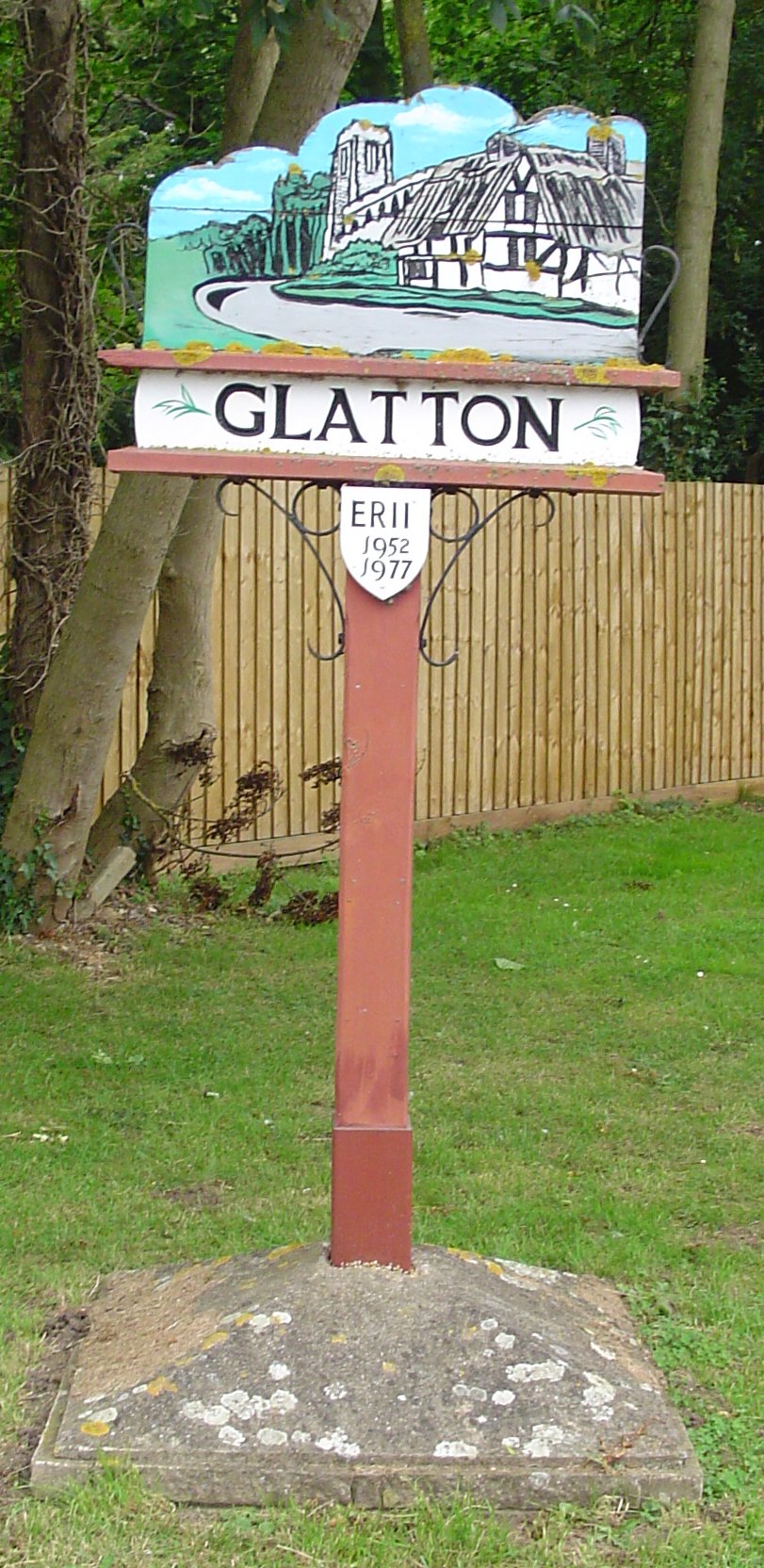
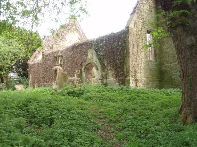
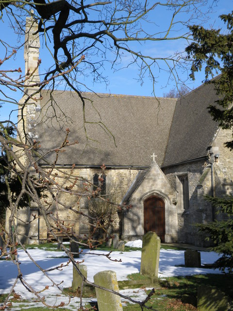
Glatton

Settlement in Huntingdonshire Huntingdonshire

England

Glatton

Glatton, St Nicholas
Glatton, St Nicholas Credit: Dave Kelly

The requested URL returned error: 429 Too Many Requests

If you have any feedback on the listing, please let us know in the comments section below.

Glatton Images

Images are sourced within 2km of 52.46118/-0.30367 or Grid Reference TL1586. Thanks to Geograph Open Source API. All images are credited.

Glatton, St Nicholas
A1(M) southbound, approaching Sawtry The A1 is the longest numbered road in the UK at 410 miles long. It connects London with Edinburgh, via the east of England. 
For much of its path it follows the Great North Road the old coaching route between London and Edinburgh. Several sections of the route are classified as motorway A1(M). The modern A1 bypasses the towns the Great North Road passed through and is dual carriageway for most of its route through England.
A1(M) southbound, approaching Sawtry
The A1 is the longest numbered road in the UK at 410 miles long. It connects London with Edinburgh, via the east of England. For much of its path it follows the Great North Road the old coaching route between London and Edinburgh. Several sections of the route are classified as motorway A1(M). The modern A1 bypasses the towns the Great North Road passed through and is dual carriageway for most of its route through England.
A1(M), northbound The A1 is the longest numbered road in the UK at 410 miles long. It connects London with Edinburgh, via the east of England. 
For much of its path it follows the Great North Road the old coaching route between London and Edinburgh. Several sections of the route are classified as motorway A1(M). The modern A1 bypasses the towns the Great North Road passed through and is dual carriageway for most of its route through England.
A1(M), northbound
The A1 is the longest numbered road in the UK at 410 miles long. It connects London with Edinburgh, via the east of England. For much of its path it follows the Great North Road the old coaching route between London and Edinburgh. Several sections of the route are classified as motorway A1(M). The modern A1 bypasses the towns the Great North Road passed through and is dual carriageway for most of its route through England.
Glatton Ways Bridge, A1(M) The A1 is the longest numbered road in the UK at 410 miles long. It connects London with Edinburgh, via the east of England. 
For much of its path it follows the Great North Road the old coaching route between London and Edinburgh. Several sections of the route are classified as motorway A1(M). The modern A1 bypasses the towns the Great North Road passed through and is dual carriageway for most of its route through England.
Glatton Ways Bridge, A1(M)
The A1 is the longest numbered road in the UK at 410 miles long. It connects London with Edinburgh, via the east of England. For much of its path it follows the Great North Road the old coaching route between London and Edinburgh. Several sections of the route are classified as motorway A1(M). The modern A1 bypasses the towns the Great North Road passed through and is dual carriageway for most of its route through England.
A1(M), northbound The A1 is the longest numbered road in the UK at 410 miles long. It connects London with Edinburgh, via the east of England. 
For much of its path it follows the Great North Road the old coaching route between London and Edinburgh. Several sections of the route are classified as motorway A1(M). The modern A1 bypasses the towns the Great North Road passed through and is dual carriageway for most of its route through England.
A1(M), northbound
The A1 is the longest numbered road in the UK at 410 miles long. It connects London with Edinburgh, via the east of England. For much of its path it follows the Great North Road the old coaching route between London and Edinburgh. Several sections of the route are classified as motorway A1(M). The modern A1 bypasses the towns the Great North Road passed through and is dual carriageway for most of its route through England.
B1043/Conington Lane junction
US Army Eighth Air Force war memorial
US Army Eighth Air Force war memorial and water tank The enormous water tank and tower is in the next square and is a remnant of the former air base.
US Army Eighth Air Force war memorial and water tank
The enormous water tank and tower is in the next square and is a remnant of the former air base.
B1043 southbound
B1043 southbound
Glatton Ways
Glatton Ways
Entrance to Glatton
Entrance to Glatton
Infield Road
Infield Road
Access to Glatton Lodge Farm
Glatton Lane
Glatton Lane
B1043 southbound
B1043 southbound
WW II War Memorial
WW II War Memorial
B660 road bridge over A1(M)
Show me another place!

Glatton is located at Grid Ref: TL1586 (Lat: 52.46118, Lng: -0.30367)

Administrative County: Cambridgeshire

District: Huntingdonshire

Police Authority: Cambridgeshire

What 3 Words

///careful.flagpole.sprinkler. Near Sawtry, Cambridgeshire

Nearby Locations

Glatton

Related Wikis

Glatton

Glatton is a village and civil parish in Cambridgeshire, England, some 8 miles (13 km) south-west of Peterborough, near the villages of Conington, Yaxley...

Denton, Cambridgeshire

Denton is a hamlet and former civil parish, now in the parish of Denton and Caldecote, in Cambridgeshire, England. Denton lies approximately 11 miles...

Denton and Caldecote

Denton and Caldecote – in Huntingdonshire (now part of Cambridgeshire), England – is a civil parish near Glatton south west of Yaxley. The parish was formed...

Folksworth

Folksworth is a village and former civil parish, now in the parish of Folksworth and Washingley, in Cambridgeshire, England. Folksworth lies approximately...

Nearby Amenities

Located within 500m of 52.46118,-0.30367
Glatton
Place: village
Lat/Long: 52.4624333/-0.3009299
Bus Stop
Sawtry Road
Bus: yes
Naptan AtcoCode: 0500HGLAT001
Naptan Bearing: NE
Naptan CommonName: Sawtry Road
Naptan Indicator: opp
Naptan Landmark: Sawtry Road
Naptan NaptanCode: cmbdpamp
Naptan ShortCommonName: Sawtry Road
Naptan Street: Glatton Ways
Naptan Verified: no
Public Transport: platform
Source: naptan_import
Lat/Long: 52.4605702/-0.3022849
Bus Stop
Sawtry Road
Bus: yes
Naptan AtcoCode: 0500HGLAT002
Naptan Bearing: SW
Naptan BusStopType: CUS
Naptan CommonName: Sawtry Road
Naptan Indicator: near
Naptan Landmark: Sawtry Road
Naptan NaptanCode: cmbdpamt
Naptan ShortCommonName: Sawtry Road
Naptan Street: Glatton Ways
Naptan Verified: no
Public Transport: platform
Source: naptan_import
Lat/Long: 52.4605092/-0.3021307
Nursing Home
Glatton Hall
Operator: Saint George's
Lat/Long: 52.4618261/-0.3017568
Pub
Addison Arms
Wikidata: Q26510380
Lat/Long: 52.4589863/-0.3011837
Telephone
Booth: K6
Covered: booth
Man Made: telephone_box
Lat/Long: 52.4598566/-0.3028248
Post Box
Post Box Type: pillar
Ref: PE28 178
Royal Cypher: EIIR
Royal Cypher Wikidata: Q33102113
Lat/Long: 52.459816/-0.3030314
Power: pole
Lat/Long: 52.4571847/-0.3042108
Power: pole
Lat/Long: 52.4571537/-0.300858
Power: pole
Lat/Long: 52.4571568/-0.3021455
Power: pole
Lat/Long: 52.4571798/-0.3031486
Place: farm
Lat/Long: 52.4607152/-0.299077
Defibrillator
Defibrillator Location: outside Glatton Village Hall
Emergency: defibrillator
Indoor: no
Lat/Long: 52.4609819/-0.3029404
The data included in this document is from www.openstreetmap.org. The data is made available under ODbL.

Have you been to Glatton?

Leave your review of Glatton below (or comments, questions and feedback).