Gestingthorpe

Settlement in Essex Braintree

England

Gestingthorpe

Farmhouse at Hopkins Farm, Essex This farm stands about a mile west of Gestingthorpe.
Farmhouse at Hopkins Farm, Essex Credit: Robert Edwards

Gestingthorpe is a small village located in the Braintree district of Essex, England. Situated approximately 3 miles northeast of Halstead, it is surrounded by picturesque countryside and offers a tranquil setting for its residents. The village is part of the Stour Valley, known for its natural beauty and stunning landscapes.

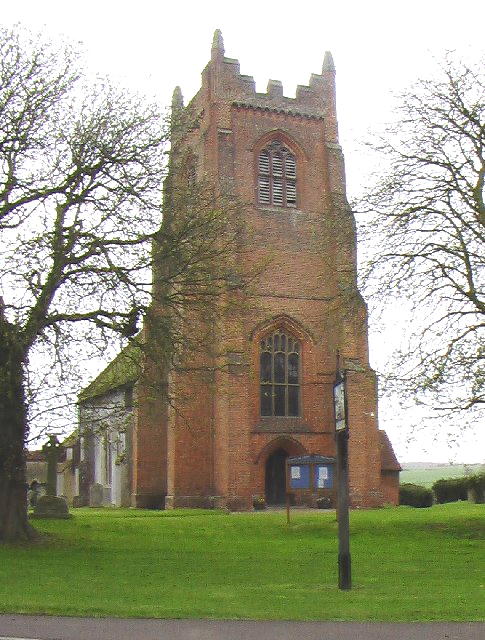
With a population of around 350 people, Gestingthorpe maintains a tight-knit community atmosphere. The village is characterized by its charming traditional cottages, some of which date back to the 16th century, giving it a distinct historical feel. The local parish church, St. Mary the Virgin, is an ancient structure with a rich history, providing a focal point for the community.

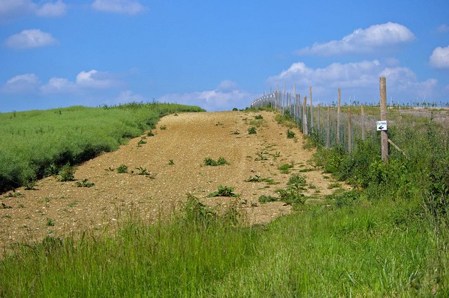
Gestingthorpe is primarily an agricultural community, with farming playing a significant role in the local economy. The surrounding fields are used for arable farming, providing a picturesque backdrop throughout the changing seasons. The village also benefits from its proximity to the nearby market towns of Halstead and Sudbury, which offer a range of amenities including shops, schools, and leisure facilities.

The village hosts various community events and activities, fostering a sense of togetherness among its residents. The Gestingthorpe Show, held annually, showcases local produce, crafts, and entertainment, attracting visitors from across the region. The village also boasts several footpaths and bridleways, allowing for enjoyable walks and horse riding in the surrounding countryside.

In summary, Gestingthorpe is a quaint and idyllic village in Essex, offering a peaceful rural lifestyle and a strong sense of community. Its natural beauty, historic buildings, and agricultural heritage make it a charming place to live or visit.

If you have any feedback on the listing, please let us know in the comments section below.

Gestingthorpe Images

Images are sourced within 2km of 52.01814/0.638819 or Grid Reference TL8138. Thanks to Geograph Open Source API. All images are credited.

Farmhouse at Hopkins Farm, Essex This farm stands about a mile west of Gestingthorpe.
Farmhouse at Hopkins Farm, Essex
This farm stands about a mile west of Gestingthorpe.
A short signpost
A short signpost
Footpath to Parkgate Farm The narrow path follows the edge of this ploughed field.
Footpath to Parkgate Farm
The narrow path follows the edge of this ploughed field.
Fields at North End An autumn mist hangs over these dark ploughed fields, near the hamlet of North End.
Fields at North End
An autumn mist hangs over these dark ploughed fields, near the hamlet of North End.
Oaks into the distance Open flat landscape of North Essex. A field of young rape in the foreground.
Oaks into the distance
Open flat landscape of North Essex. A field of young rape in the foreground.
Western edge of Ridley's Wood A footpath takes a northerly direction using the generous headland; full marks to the farmer!
Western edge of Ridley's Wood
A footpath takes a northerly direction using the generous headland; full marks to the farmer!
The Lych Gate, St Mary's Church, Gestingthorpe
St Mary's Church, Gestingthorpe, Essex
Pond at Gestingthorpe A pond in the grounds of a private house fronting the road through Gestingthorpe village.
Pond at Gestingthorpe
A pond in the grounds of a private house fronting the road through Gestingthorpe village.
Thatching in progress A roof being re-thatched close to the church in Gestingthorpe village
Thatching in progress
A roof being re-thatched close to the church in Gestingthorpe village
Rectory Farm, Gestingthorpe, Essex
Nether Hall Farm, Gestingthorpe, Essex
North End Road, looking towards Gestingthorpe
Sudbury Road
Sudbury Road
Countryside along the Sudbury Road
Sudbury Road, heading towards Bulmer, Essex
Cottages and farm buildings The buildings on the left belong to Parkgate Farm and the road, leading up to the cottages, is called Delvyn's Lane.
Cottages and farm buildings
The buildings on the left belong to Parkgate Farm and the road, leading up to the cottages, is called Delvyn's Lane.
Footpath to Hill Farm The footpath to Hall Farm is now bordered by a rabbit/deer proof fence defending a new tree plantation.
Footpath to Hill Farm
The footpath to Hall Farm is now bordered by a rabbit/deer proof fence defending a new tree plantation.
Show me another place!

Gestingthorpe is located at Grid Ref: TL8138 (Lat: 52.01814, Lng: 0.638819)

Administrative County: Essex

District: Braintree

Police Authority: Essex

What 3 Words

///aviators.commands.names. Near Castle Hedingham, Essex

Nearby Locations

Gestingthorpe

Related Wikis

Gestingthorpe

Gestingthorpe (pronounced GEST-ing-thorp, 'guesstingthorpe') is a village and a civil parish in the Braintree district, in the English county of Essex...

Belchamp Walter

Belchamp Walter is a village and civil parish in Essex, England. It is located approximately 5 km (3.1 mi) west of Sudbury, Suffolk and is 35 km (22 miles...

Belchamp Hall

Belchamp Hall is a Queen Anne style country house in Belchamp Walter, near Braintree, Essex, England. It is a privately owned Grade II* listed building...

Wickham St. Paul

Wickham St Paul is a village and civil parish located five miles north of Halstead in the district of Braintree, Essex. The village, in which some of the...

Nearby Amenities

Located within 500m of 52.01814,0.638819
Gestingthorpe
Is In: Essex
Place: village
Lat/Long: 52.0171551/0.6394522
Post Box
Operator: Royal Mail
Post Box Type: lamp
Ref: CO9 56
Lat/Long: 52.0184732/0.638787
Telephone
Defibrillator
Access: yes
Booth: K6
Covered: booth
Defibrillator Location: inside old red phone box by the church in Gestingthorpe
Emergency: defibrillator
Listed Status: Grade II
Man Made: telephone_box
Source: gps
Lat/Long: 52.0162391/0.639011
Hall Farm
Naptan AtcoCode: 150024014017
Naptan Bearing: S
Naptan BusStopType: CUS
Naptan CommonName: Hall Farm
Naptan Indicator: Opp
Naptan Landmark: Hall Farm
Naptan NaptanCode: esxdjdmt
Naptan Street: Church Street
Naptan Verified: no
Public Transport: platform
Source: naptan_import
Lat/Long: 52.0151523/0.6385283
Hall Farm
Naptan AtcoCode: 150024014Y07
Naptan Bearing: N
Naptan BusStopType: CUS
Naptan CommonName: Hall Farm
Naptan Indicator: o/s
Naptan Landmark: Hall Farm
Naptan NaptanCode: esxgpdjg
Naptan Street: Church Street
Naptan Verified: no
Public Transport: platform
Source: naptan_import
Lat/Long: 52.0151453/0.6384405
Nether Hill
Naptan AtcoCode: 150024015001
Naptan Bearing: E
Naptan BusStopType: CUS
Naptan CommonName: Nether Hill
Naptan Crossing: Nether Hill Road
Naptan Indicator: E-bound
Naptan Landmark: Nether Hill
Naptan NaptanCode: esxdjdmw
Naptan Street: Sudbury Road
Naptan Verified: no
Public Transport: platform
Source: naptan_import
Lat/Long: 52.0185504/0.6421975
Nether Hill
Naptan AtcoCode: 150024015Y01
Naptan Bearing: W
Naptan BusStopType: CUS
Naptan CommonName: Nether Hill
Naptan Crossing: Nether Hill Road
Naptan Indicator: W-bound
Naptan Landmark: Nether Hill
Naptan NaptanCode: esxgtpat
Naptan Street: Sudbury Road
Naptan Verified: no
Public Transport: platform
Source: naptan_import
Lat/Long: 52.0184965/0.6421944
Foundry Corner
Naptan AtcoCode: 1500IM707
Naptan Bearing: N
Naptan BusStopType: CUS
Naptan CommonName: Foundry Corner
Naptan Crossing: Northend Road
Naptan Indicator: N-bound
Naptan Landmark: Foundry Corner
Naptan NaptanCode: esxadgjg
Naptan Street: Church Street
Naptan Verified: no
Public Transport: platform
Source: naptan_import
Lat/Long: 52.017907/0.6388071
Foundry Corner
Naptan AtcoCode: 1500IM707B
Naptan Bearing: S
Naptan BusStopType: CUS
Naptan CommonName: Foundry Corner
Naptan Crossing: Northend Road
Naptan Indicator: S-bound
Naptan Landmark: Foundry Corner
Naptan NaptanCode: esxdjamt
Naptan Street: Church Street
Naptan Verified: no
Public Transport: platform
Source: naptan_import
Lat/Long: 52.018059/0.6388452
Man Made: village_sign
Lat/Long: 52.0159503/0.6388578
Information: guidepost
Tourism: information
Lat/Long: 52.0182916/0.6388623
The data included in this document is from www.openstreetmap.org. The data is made available under ODbL.

Have you been to Gestingthorpe?

Leave your review of Gestingthorpe below (or comments, questions and feedback).