Loch na Cartach

Lake, Pool, Pond, Freshwater Marsh in Inverness-shire

Scotland

Loch na Cartach

Borve Dun from the South The summit cairn of Borve Dun with the township of Borve in the middle distance and Taransay beyond
Borve Dun from the South Credit: Richard Barrett

Loch na Cartach is a freshwater loch located in Inverness-shire, Scotland. Nestled in the picturesque Scottish Highlands, the loch is surrounded by stunning natural beauty, offering visitors a tranquil and serene atmosphere.

Covering an area of approximately 1.5 hectares, Loch na Cartach is a relatively small body of water. It is known for its crystal-clear waters, which are fed by numerous small streams and springs that flow from the surrounding hills. The loch is situated amidst lush greenery, with dense forests and rolling hills in the backdrop, creating a breathtaking scenery.

The loch serves as a vital habitat for various species of aquatic flora and fauna. It is home to a diverse range of fish, including brown trout and pike, making it a popular destination for anglers. Additionally, the surrounding marshes provide a haven for numerous bird species, attracting birdwatchers from far and wide.

Access to Loch na Cartach is relatively easy, with a well-maintained pathway leading to the loch. Visitors can enjoy leisurely walks or picnics along the shore, taking in the tranquil ambiance and stunning views. The loch also offers opportunities for boating and kayaking, allowing visitors to explore its calm waters and soak in the surrounding natural beauty.

Overall, Loch na Cartach is a hidden gem in Inverness-shire, offering a peaceful retreat for nature enthusiasts and those seeking a break from the hustle and bustle of daily life. Its serene atmosphere, coupled with its stunning surroundings and diverse wildlife, make it a must-visit destination for anyone exploring the Scottish Highlands.

If you have any feedback on the listing, please let us know in the comments section below.

Loch na Cartach Images

Images are sourced within 2km of 57.82169/-6.9875905 or Grid Reference NG0392. Thanks to Geograph Open Source API. All images are credited.
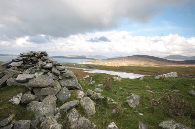
Borve Dun from the South The summit cairn of Borve Dun with the township of Borve in the middle distance and Taransay beyond
Borve Dun from the South
The summit cairn of Borve Dun with the township of Borve in the middle distance and Taransay beyond
Course of the Allt Dritil, Harris
Loch na h-Uamha, Harris The large loch behind is Loch Langabhat. The high ground on the left is Bhoiseabhal and coming down from the right is Bleabhal.
Loch na h-Uamha, Harris
The large loch behind is Loch Langabhat. The high ground on the left is Bhoiseabhal and coming down from the right is Bleabhal.
Ruined building below Sleiteabhal, Harris Looking towards Bleabhal.
Ruined building below Sleiteabhal, Harris
Looking towards Bleabhal.
Loch below Sleiteabhal, Harris Approximately 40% of the length of the loch lies within the grid square.
Loch below Sleiteabhal, Harris
Approximately 40% of the length of the loch lies within the grid square.
Dyke by the Allt a' Choire, Harris The distinctive wiggly line of the dyke is shown on OS maps with a scale of 1:25,000 and larger.
Dyke by the Allt a' Choire, Harris
The distinctive wiggly line of the dyke is shown on OS maps with a scale of 1:25,000 and larger.
Lochan on moorland below Bulabhall, Harris
Dyke, Meabhal, Harris The dyke is shown on OS maps with a scale of 1:25,000 and larger.
Dyke, Meabhal, Harris
The dyke is shown on OS maps with a scale of 1:25,000 and larger.
Exposed rock, Bràigh Buidhe, Harris <a href="https://www.geograph.org.uk/photo/3080518">NG0294 : Traigh Mhor, Scarasta</a> can just be seen on the right and the island is the western side of Taransay/Tarasaigh.
Exposed rock, Bràigh Buidhe, Harris
NG0294 : Traigh Mhor, Scarasta can just be seen on the right and the island is the western side of Taransay/Tarasaigh.
Boggy pools on the eastern slopes of Bleabhal, Harris Looking towards Roineabhal, the highest point in south Harris.
Boggy pools on the eastern slopes of Bleabhal, Harris
Looking towards Roineabhal, the highest point in south Harris.
Blackhouse footings below Loch Iochtabhat, Harris The blackhouse measured about 5.5 x 10m and had walls 1.5m thick.

A Hebridean Way marker post can be seen behind the top right of the footings.
Blackhouse footings below Loch Iochtabhat, Harris
The blackhouse measured about 5.5 x 10m and had walls 1.5m thick. A Hebridean Way marker post can be seen behind the top right of the footings.
Cup marked rock by Dun Bhuirgh, Harris An exposed rock surface which measures about 5x2m has 40 cup marks on it ranging in diameter from 80 - 130mm.  See <span class="nowrap"><a title="https://canmore.org.uk/site/10553" rel="nofollow ugc noopener" href="https://canmore.org.uk/site/10553">Link</a><img style="margin-left:2px;" alt="External link" title="External link - shift click to open in new window" src="https://s1.geograph.org.uk/img/external.png" width="10" height="10"/></span> .
Cup marked rock by Dun Bhuirgh, Harris
An exposed rock surface which measures about 5x2m has 40 cup marks on it ranging in diameter from 80 - 130mm. See LinkExternal link .
Bleabhal trig point The trig point on Bleabhal.
Bleabhal trig point
The trig point on Bleabhal.
The Shieling An old shieling on the lower slopes of Bleabhal.
The Shieling
An old shieling on the lower slopes of Bleabhal.
Meabhal Looking down towards Meabhal from Bleabhal.
Meabhal
Looking down towards Meabhal from Bleabhal.
Gleann a'Chaimire This short glen runs south from Bleaval (398m).
Gleann a'Chaimire
This short glen runs south from Bleaval (398m).
Bleaval [Bleabhal] Parked at post office but parking further south near standing stone probably better. Done with Jim Bloomer and Mat Webster.
Name: Bleaval [Bleabhal]
Hill number: 1599
Height: 398m / 1306ft
Area: 24B: Harris and Nearby Islands
Class: Ma
Grid ref: NG 03045 91437
Summit feature: rock 1m W of trig
Drop: 333m
Col: 65m  NG038927
Bleaval [Bleabhal]
Parked at post office but parking further south near standing stone probably better. Done with Jim Bloomer and Mat Webster. Name: Bleaval [Bleabhal] Hill number: 1599 Height: 398m / 1306ft Area: 24B: Harris and Nearby Islands Class: Ma Grid ref: NG 03045 91437 Summit feature: rock 1m W of trig Drop: 333m Col: 65m NG038927
Bleaval [Bleabhal] Bleaval [Bleabhal] cairn some way from summit but most of the hard work has been done with Jim Bloomer and Mat Webster.
Bleaval [Bleabhal]
Bleaval [Bleabhal] cairn some way from summit but most of the hard work has been done with Jim Bloomer and Mat Webster.
Show me another place!

Loch na Cartach is located at Grid Ref: NG0392 (Lat: 57.82169, Lng: -6.9875905)

Unitary Authority: Na h-Eileanan an Iar

Police Authority: Highlands and Islands

What 3 Words

///newsprint.snap.dwarf. Near Leverburgh, Na h-Eileanan Siar

Nearby Locations

Loch na Cartach

Related Wikis

Borve, Harris

Borve (Scottish Gaelic: Na Buirgh) is a village in Harris in the Outer Hebrides, Scotland. Borve is also within the parish of Harris, and is on the A859...

1990 Scotland RAF Shackleton crash

On 30 April 1990, a Royal Air Force Avro Shackleton AEW Mk II aircraft, of No. 8 Squadron RAF, based at RAF Lossiemouth, crashed into a hill on the Isle...

Roineabhal

Roineabhal is a hill in Harris, in the Western Isles of Scotland. The granite on the summit plateau of the mountain is anorthosite, and is similar in composition...

Leverburgh

Leverburgh (Scottish Gaelic: An t-Òb [ən̪ˠ ˈt̪ɔːp]) is the second largest village, after Tarbert, in Harris in the Outer Hebrides of Scotland. Leverburgh...

Have you been to Loch na Cartach?

Leave your review of Loch na Cartach below (or comments, questions and feedback).