Gead an t-Sailleir

Settlement in Inverness-shire

Scotland

Gead an t-Sailleir

Camas a' Mhòr-bheòil Looking north from the beach towards Ben Tianavaig.
Camas a' Mhòr-bheòil Credit: Ian Taylor

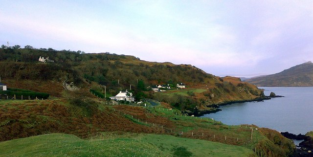
Gead an t-Sailleir is a small hamlet located in Inverness-shire, Scotland. Situated in the stunning Scottish Highlands, it is surrounded by picturesque landscapes and offers a tranquil and serene environment.

The hamlet is located approximately 10 miles south of the town of Inverness, making it easily accessible for both residents and visitors. It is situated near the banks of the River Ness, providing breathtaking views and opportunities for outdoor activities such as fishing and hiking.

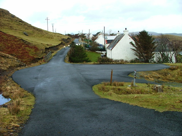
Gead an t-Sailleir is known for its traditional Scottish charm and friendly community. The local residents take great pride in maintaining the natural beauty of the area, and the hamlet has managed to retain its traditional architecture and atmosphere. Visitors can expect to see quaint cottages and stone buildings that are characteristic of the region.

The surrounding area offers a wealth of attractions and activities for visitors to enjoy. Just a short distance away is Loch Ness, famous for its mysterious monster. Visitors can explore the loch by boat or take a leisurely stroll along its shores. The nearby Cairngorms National Park is a haven for outdoor enthusiasts, offering opportunities for hiking, skiing, and wildlife spotting.

In terms of amenities, Gead an t-Sailleir has a few local shops and services to cater to the needs of its residents. For a wider range of facilities, the town of Inverness is a short drive away.

Overall, Gead an t-Sailleir is a charming and peaceful hamlet in the heart of the Scottish Highlands. Its natural beauty and proximity to attractions make it a desirable destination for those seeking a tranquil escape.

If you have any feedback on the listing, please let us know in the comments section below.

Gead an t-Sailleir Images

Images are sourced within 2km of 57.340204/-6.11757 or Grid Reference NG5235. Thanks to Geograph Open Source API. All images are credited.

Camas a' Mhòr-bheòil Looking north from the beach towards Ben Tianavaig.
Camas a' Mhòr-bheòil
Looking north from the beach towards Ben Tianavaig.
Southwards from An Aird Looking across the tombolo and Balmeanach Bay towards Glamaig.
Southwards from An Aird
Looking across the tombolo and Balmeanach Bay towards Glamaig.
Loch an Amadain Looking north from An Aird towards Ben Tianavaig, with The Storr in the far distance.
Loch an Amadain
Looking north from An Aird towards Ben Tianavaig, with The Storr in the far distance.
Shoreline rocks, An Aird
Balmeanach Looking south over Balmeanach Bay, to the headland Tòrr Mòr (in the centre).
The hill to the left is Meall a' Mhaoil, with Sconser Quarry just visible.
The red hills are beyond.
Balmeanach
Looking south over Balmeanach Bay, to the headland Tòrr Mòr (in the centre). The hill to the left is Meall a' Mhaoil, with Sconser Quarry just visible. The red hills are beyond.
Shore at the Braes Looking north from above the beach towards Ben Tianavaig.
Camas a' Mhòr-bheòil extends to the right (east).
Sheep are grazing the steep slopes.
Shore at the Braes
Looking north from above the beach towards Ben Tianavaig. Camas a' Mhòr-bheòil extends to the right (east). Sheep are grazing the steep slopes.
Balmeanach Bay The north side of the bay is a low-lying spit, and in the background are the lava cliffs north of Portree.
Balmeanach Bay
The north side of the bay is a low-lying spit, and in the background are the lava cliffs north of Portree.
Marker buoy on McMillan's Rock McMillan's Rock is a small low-water rock situate near the narrow channel between Raasay and An Aird on Skye. It can only be seen at extreme low tides, and is marked by this buoy.
Marker buoy on McMillan's Rock
McMillan's Rock is a small low-water rock situate near the narrow channel between Raasay and An Aird on Skye. It can only be seen at extreme low tides, and is marked by this buoy.
Peinachorran Peinachorran is a string of white houses along a dead-end road south from Portree. Camera position from in-camera GPS.
Peinachorran
Peinachorran is a string of white houses along a dead-end road south from Portree. Camera position from in-camera GPS.
Balmeanach Bay The headland right of centre here is in square, as is the sea between camera and headland. Camera position from in-camera GPS. In the next square is Peinachorran.
Balmeanach Bay
The headland right of centre here is in square, as is the sea between camera and headland. Camera position from in-camera GPS. In the next square is Peinachorran.
An Àird and Beinn Teanabhaig There is land in this square in this direction, but it's only a tiny strip of shore at low tide, and is probably submerged at the moment. In any case who would look at a few seaweedy boulders when there is Ben Tianavaig to draw the eye? The distinctive shape of this mountain is because everything to the right of the sharp ridge is a massive landslip. An Àird is the headland nearer the camera. Camera position from in-camera GPS.
An Àird and Beinn Teanabhaig
There is land in this square in this direction, but it's only a tiny strip of shore at low tide, and is probably submerged at the moment. In any case who would look at a few seaweedy boulders when there is Ben Tianavaig to draw the eye? The distinctive shape of this mountain is because everything to the right of the sharp ridge is a massive landslip. An Àird is the headland nearer the camera. Camera position from in-camera GPS.
Peinachorrain & Glamaig from An Aird, Skye The narrow strip of land connecting An Aird to The Braes can be seen to the right. Glamaig to the left, but the Cuillins mostly hidden by cloud.
Peinachorrain & Glamaig from An Aird, Skye
The narrow strip of land connecting An Aird to The Braes can be seen to the right. Glamaig to the left, but the Cuillins mostly hidden by cloud.
Braesburn Hall, revised Building work is currently underway which will convert the original Braesburn Hall into a domestic dwelling. The new-build will have two en-suite bedrooms, one on the ground floor and one in the roof. The original doorway is to be filled-in, and one arched window becomes rectangular. A new extension on the southern side of the building will provide a sun-lounge. 
Former images of the hall: 
<a href="https://www.geograph.org.uk/photo/677700">NG5136 : Braesburn Hall</a>
<a href="https://www.geograph.org.uk/photo/1454752">NG5136 : Building work at the church hall</a>
Braesburn Hall, revised
Building work is currently underway which will convert the original Braesburn Hall into a domestic dwelling. The new-build will have two en-suite bedrooms, one on the ground floor and one in the roof. The original doorway is to be filled-in, and one arched window becomes rectangular. A new extension on the southern side of the building will provide a sun-lounge. Former images of the hall: NG5136 : Braesburn Hall NG5136 : Building work at the church hall
Braesburn Hall, revised Building work is currently underway which will convert the original Braesburn Hall into a domestic dwelling. The new-build will have two en-suite bedrooms, one on the ground floor and one in the roof, with roof-lights. The original doorway is to be filled-in, and one arched window becomes rectangular. A new extension on the southern side of the building will provide a sun-lounge.
Former images of the hall:
<a href="https://www.geograph.org.uk/photo/677700">NG5136 : Braesburn Hall</a>
<a href="https://www.geograph.org.uk/photo/1454752">NG5136 : Building work at the church hall</a>
Braesburn Hall, revised
Building work is currently underway which will convert the original Braesburn Hall into a domestic dwelling. The new-build will have two en-suite bedrooms, one on the ground floor and one in the roof, with roof-lights. The original doorway is to be filled-in, and one arched window becomes rectangular. A new extension on the southern side of the building will provide a sun-lounge. Former images of the hall: NG5136 : Braesburn Hall NG5136 : Building work at the church hall
Path to the beach This little un-signposted path leads to one of Skye's most attractive beaches.
Don't tell everyone!
Path to the beach
This little un-signposted path leads to one of Skye's most attractive beaches. Don't tell everyone!
The Braes road, and Balmeanach Bay Looking south-east from Gedintailor. 
The Braes is a district, made up of a number of small townships.
The narrow, single-track road is the only road access, and eventually comes to a dead-end.
The Braes road, and Balmeanach Bay
Looking south-east from Gedintailor. The Braes is a district, made up of a number of small townships. The narrow, single-track road is the only road access, and eventually comes to a dead-end.
B883 towards Peinachorrain Although this road is shown on maps as the more major of the roads to Peinachorrian, it has now deteriorated to being little more than a farm track.
The similarly narrow minor road to the east is slightly better maintained, and is the favoured route for vehicles.
B883 towards Peinachorrain
Although this road is shown on maps as the more major of the roads to Peinachorrian, it has now deteriorated to being little more than a farm track. The similarly narrow minor road to the east is slightly better maintained, and is the favoured route for vehicles.
Rainbow over the B883 Although designated as the more major road through this part of The Braes, the surface of the B883 has deteriorated seriously and is now little more than a farm track.
Rainbow over the B883
Although designated as the more major road through this part of The Braes, the surface of the B883 has deteriorated seriously and is now little more than a farm track.
Show me another place!

Gead an t-Sailleir is located at Grid Ref: NG5235 (Lat: 57.340204, Lng: -6.11757)

Unitary Authority: Highland

Police Authority: Highlands and Islands

Also known as: Gedintailor

What 3 Words

///ticket.unloads.trackers. Near Portree, Highland

Related Wikis

Gedintailor

Gedintailor (Scottish Gaelic: Gead an t-Sailleir) is a crofting village, lying on the shores of the Narrows of Raasay on the east coast of the island of...

Ollach

Ollach (in Scottish Gaelic, An t-Olach) is a remote settlement, made up of Lower Ollach and Upper Ollach, lying on B883 road, south of Portree, Isle of...

Peinachorran

Peinchorran (Scottish Gaelic: Peighinn a' Chorrain; Peinachorrain on Ordnance Survey maps) is a remote settlement, lying at the end of the B883 road, on...

Isle of Raasay distillery

Isle of Raasay distillery is a Scotch whisky distillery on the Inner Hebridean Isle of Raasay in Northwest Scotland. The distillery is owned by R&B Distillers...

Nearby Amenities

Located within 500m of 57.340204,-6.11757
Passing Place
Lat/Long: 57.3444882/-6.1190189
Passing Place
Lat/Long: 57.3436102/-6.1186176
Passing Place
Lat/Long: 57.3430259/-6.1185526
Passing Place
Lat/Long: 57.3420443/-6.1181082
Passing Place
Lat/Long: 57.3411732/-6.1172533
Passing Place
Lat/Long: 57.3399285/-6.1156744
Passing Place
Lat/Long: 57.33875/-6.1148127
Passing Place
Lat/Long: 57.3372801/-6.1135967
Passing Place
Lat/Long: 57.3366136/-6.1130887
Post Box
Gedintailor
Collection Times: Mo-Fr 10:00; Sa 10:00
Ref: IV51 8
Lat/Long: 57.3379318/-6.1141457
Bench
Backrest: yes
Material: wood
Source: survey
Lat/Long: 57.3381392/-6.1120513
Access Cattle: no
Barrier: cattle_grid
Lat/Long: 57.3408193/-6.1197029
Gedintailor
Name Gd: Gead an t-Sailleir
Place: hamlet
Wikidata: Q2409023
Wikipedia: en:Gedintailor
Lat/Long: 57.3406799/-6.1175072
Power: pole
Lat/Long: 57.336013/-6.1194277
Power: pole
Lat/Long: 57.3368758/-6.1200231
Power: pole
Lat/Long: 57.3374867/-6.1204577
Power: pole
Lat/Long: 57.3378761/-6.1207286
Power: pole
Lat/Long: 57.3386939/-6.1212999
Power: pole
Lat/Long: 57.3408507/-6.1228287
Power: pole
Lat/Long: 57.3422879/-6.1238158
Power: pole
Lat/Long: 57.3396404/-6.1174092
Power: pole
Lat/Long: 57.3386563/-6.1163807
Power: pole
Lat/Long: 57.3378413/-6.1159113
Power: pole
Lat/Long: 57.3360883/-6.1147955
Power: pole
Lat/Long: 57.3369771/-6.1153373
Power: pole
Lat/Long: 57.3369808/-6.1124955
Access Cattle: no
Barrier: cattle_grid
Lat/Long: 57.3401226/-6.1177969
Power: pole
Lat/Long: 57.3400976/-6.117931
Power: pole
Lat/Long: 57.3406066/-6.1183998
Power: pole
Lat/Long: 57.3413309/-6.1185846
Power: pole
Lat/Long: 57.341876/-6.1187273
Power: pole
Lat/Long: 57.3426874/-6.1189427
Power: pole
Lat/Long: 57.3421368/-6.1215679
Power: pole
Lat/Long: 57.3417747/-6.1209988
Power: pole
Lat/Long: 57.3414456/-6.1204907
Power: pole
Lat/Long: 57.3410033/-6.1203568
Power: pole
Lat/Long: 57.3403482/-6.1201749
Power: pole
Lat/Long: 57.340056/-6.1198153
Power: pole
Lat/Long: 57.3399067/-6.1188401
Power: pole
Lat/Long: 57.3397936/-6.1180468
Power: pole
Lat/Long: 57.3396019/-6.1159638
Power: pole
Lat/Long: 57.3399162/-6.1165227
Power: pole
Lat/Long: 57.3404668/-6.1163233
Power: pole
Lat/Long: 57.3439536/-6.1192214
Passing Place
Lat/Long: 57.3379941/-6.114137
Passing Place
Lat/Long: 57.3392462/-6.1153319
The data included in this document is from www.openstreetmap.org. The data is made available under ODbL.

Have you been to Gead an t-Sailleir?

Leave your review of Gead an t-Sailleir below (or comments, questions and feedback).