An Gearraidh Mòr

Settlement in Inverness-shire

Scotland

An Gearraidh Mòr

Broch at Caroy Defensive position above Caroy with the remains of a broch.
Broch at Caroy Credit: John Allan

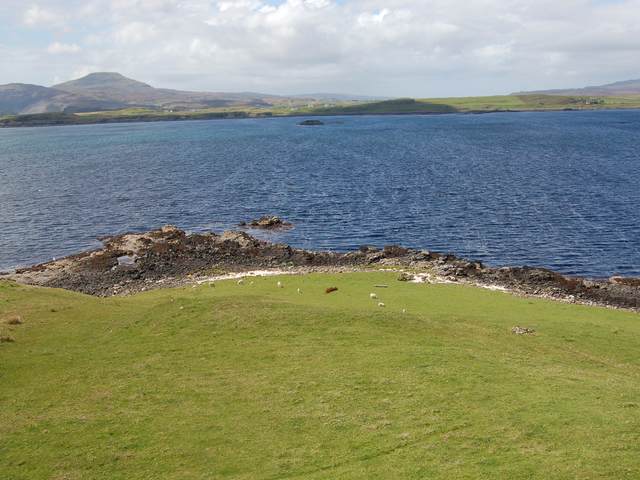
An Gearraidh Mòr, also known as Garramore, is a small village located in the scenic Inverness-shire region of Scotland. Situated on the western coast of the country, it lies on the shores of Loch Ewe, offering breathtaking views of the surrounding landscapes.

The village is known for its rich history and natural beauty. It played a significant role during World War II as a naval base, serving as an assembly point for convoys heading to the Arctic. Today, remnants of this military past can still be seen in the form of old buildings and structures.

With a population of around 300 residents, An Gearraidh Mòr is a close-knit community that thrives on traditional Scottish culture and hospitality. The locals are friendly and welcoming, often engaging in local events and festivals that celebrate their heritage.

The surrounding area provides ample opportunities for outdoor activities, attracting nature enthusiasts and adventure seekers alike. From hiking and cycling to fishing and wildlife spotting, there is something for everyone. The rugged coastline also offers stunning sandy beaches and rocky coves, perfect for peaceful walks or picnics.

Services and amenities in An Gearraidh Mòr are limited, with a small number of shops, pubs, and accommodations available. However, nearby larger towns provide additional services and facilities for residents and visitors.

Overall, An Gearraidh Mòr is a hidden gem in Inverness-shire, offering a tranquil escape from the hustle and bustle of modern life, with its natural beauty, rich history, and warm community spirit.

If you have any feedback on the listing, please let us know in the comments section below.

An Gearraidh Mòr Images

Images are sourced within 2km of 57.377269/-6.4673368 or Grid Reference NG3140. Thanks to Geograph Open Source API. All images are credited.

Broch at Caroy Defensive position above Caroy with the remains of a broch.
Broch at Caroy
Defensive position above Caroy with the remains of a broch.
Buaile Dubh Ard The A863 from Dunvegan to Sligachan cuts a substantial chunk out of the basalt of Buaile Dubh Ard.
Buaile Dubh Ard
The A863 from Dunvegan to Sligachan cuts a substantial chunk out of the basalt of Buaile Dubh Ard.
Old Road Looking north west along the old straight road that has been replaced by a new road with a big bend to avoid the boggy land.
Old Road
Looking north west along the old straight road that has been replaced by a new road with a big bend to avoid the boggy land.
House at Eabost Looking SW across Loch Bracadale. In the distance is the island of Wiay.
House at Eabost
Looking SW across Loch Bracadale. In the distance is the island of Wiay.
Mobile Bank Looks to be ready to end its days on this fairly remote farm. I wonder if the Clydesdale know it's here?
Mobile Bank
Looks to be ready to end its days on this fairly remote farm. I wonder if the Clydesdale know it's here?
Ose Farm A recently dug pit, and assorted farming equipment, on the land of Ose Farm.
Ose Farm
A recently dug pit, and assorted farming equipment, on the land of Ose Farm.
Sheep on the Old Road South of Gearymore.
Sheep on the Old Road
South of Gearymore.
Colbost Point Looking across the rough grazings above Colbost Point, near Eabost. The islands visible in Loch Bracadale are Tarner and Harlosh.
Colbost Point
Looking across the rough grazings above Colbost Point, near Eabost. The islands visible in Loch Bracadale are Tarner and Harlosh.
Grazings at Eabost West Croft land with sheep grazing. The view is across Loch Bracadale to the mouth of Loch Caroy.
Grazings at Eabost West
Croft land with sheep grazing. The view is across Loch Bracadale to the mouth of Loch Caroy.
Nae Sheep Unofficial roadsign at Caroy. I suppose it's important to stick to visual signs, because sheep in these parts can barely read. Made me smile anyway!
Nae Sheep
Unofficial roadsign at Caroy. I suppose it's important to stick to visual signs, because sheep in these parts can barely read. Made me smile anyway!
Shelter in Glen Ose Gives the sheep some protection from the weather.
Shelter in Glen Ose
Gives the sheep some protection from the weather.
Friendly sheep One of the users of the shelter <a href="https://www.geograph.org.uk/photo/279249">NG3241 : Shelter in Glen Ose</a>.
Presumably hand reared - certainly very inquisitive.
Friendly sheep
One of the users of the shelter NG3241 : Shelter in Glen Ose. Presumably hand reared - certainly very inquisitive.
Recycling bins near Struan Increasingly evident in the Scottish Highlands are collecting bins like these. No problem in a supermarket car park, or a built up area, but questionably brightly coloured for an entirely rural setting such as this one.
Recycling bins near Struan
Increasingly evident in the Scottish Highlands are collecting bins like these. No problem in a supermarket car park, or a built up area, but questionably brightly coloured for an entirely rural setting such as this one.
Ben Toirlean The trig point on the low summit of Ben Toirlean, looking towards a hazy Black Cuillin.
Ben Toirlean
The trig point on the low summit of Ben Toirlean, looking towards a hazy Black Cuillin.
Mouth of the River Ose Looking downstream towards where the river reaches the sea at Loch Bracadale.
Mouth of the River Ose
Looking downstream towards where the river reaches the sea at Loch Bracadale.
Dun Abhuinn Bhaile Mheadhonaich The remains of the dun above Loch Caroy. Only the foundation course is visible on the outside, while the inside, seen here, is filled with grassed over tumble.
Dun Abhuinn Bhaile Mheadhonaich
The remains of the dun above Loch Caroy. Only the foundation course is visible on the outside, while the inside, seen here, is filled with grassed over tumble.
Fence above Loch Caroy The fenceline heads eastwards into some isolated country above Balmeanach.
Fence above Loch Caroy
The fenceline heads eastwards into some isolated country above Balmeanach.
Bridge over the Allt Dughaill Now largely redundant, this bridge carries the old Dunvegan to Struan road over the burn.
Bridge over the Allt Dughaill
Now largely redundant, this bridge carries the old Dunvegan to Struan road over the burn.
Show me another place!

An Gearraidh Mòr is located at Grid Ref: NG3140 (Lat: 57.377269, Lng: -6.4673368)

Unitary Authority: Highland

Police Authority: Highlands and Islands

Also known as: Gearymore

What 3 Words

///unleashed.answer.diary. Near Dunvegan, Highland

Related Wikis

Ose, Skye

Ose (Scottish Gaelic: Òs) is a small coastal settlement of Loch Bracadale, in the Scottish Highland area. It lies on the west coast of the Isle of Skye...

Struan, Skye

Struan (Scottish Gaelic: An Sruthan) is a small village on the west coast of the island of Skye, on the shores of Loch Beag, itself an inlet of Loch Bracadale...

Ullinish

Ullinish (Gaelic: Uilfhinis) is a crofting township on Loch Bracadale, on the southwest coast of Skye, Scotland. The only promontory fort on Skye is located...

Tarner Island

Tarner Island is a triangular shaped island in Loch Bracadale just off the coast off the Harlosh peninsula of Skye in Scotland. It is about 28 hectares...

Nearby Amenities

Located within 500m of 57.377269,-6.4673368
Created By: dmgroom_coastlines
Source: PGS
Lat/Long: 57.37839/-6.47521
Created By: dmgroom_coastlines
Source: PGS
Lat/Long: 57.37788/-6.47525
Created By: dmgroom_coastlines
Source: PGS
Lat/Long: 57.37763/-6.4755
Created By: dmgroom_coastlines
Source: PGS
Lat/Long: 57.37774/-6.47454
Created By: dmgroom_coastlines
Source: PGS
Lat/Long: 57.37771/-6.47312
Created By: dmgroom_coastlines
Source: PGS
Lat/Long: 57.37757/-6.4729
Created By: dmgroom_coastlines
Source: PGS
Lat/Long: 57.37706/-6.47246
Created By: dmgroom_coastlines
Source: PGS
Lat/Long: 57.3768/-6.47248
Source: PGS
Lat/Long: 57.376582/-6.4721241
Source: PGS
Lat/Long: 57.3765797/-6.4715914
Source: PGS
Lat/Long: 57.3765601/-6.4712207
Created By: dmgroom_coastlines
Source: PGS
Lat/Long: 57.37642/-6.47053
Created By: dmgroom_coastlines
Source: PGS
Lat/Long: 57.37548/-6.47043
Source: PGS
Lat/Long: 57.3750715/-6.4711017
Created By: dmgroom_coastlines
Source: PGS
Lat/Long: 57.37499/-6.47165
Created By: dmgroom_coastlines
Source: PGS
Lat/Long: 57.37475/-6.47214
Created By: dmgroom_coastlines
Source: PGS
Lat/Long: 57.3745/-6.4724
Created By: dmgroom_coastlines
Source: PGS
Lat/Long: 57.37464/-6.47333
Ose
Name Gd: Òs
Place: village
Wikidata: Q2531093
Wikipedia: en:Ose, Skye
Lat/Long: 57.3798149/-6.4721654
Bus Stop
Road End
Naptan AtcoCode: 670030022A
Naptan Bearing: NW
Naptan CommonName: Road End
Naptan Indicator: opp
Naptan Landmark: Bus Shelter
Naptan NaptanCode: 45326434
Naptan Street: A863
Naptan Verified: no
Source: naptan_import
Lat/Long: 57.3786867/-6.4702331
Bus Stop
Ose
Local Ref: AT
Naptan AtcoCode: 670030022B
Naptan Bearing: SE
Naptan CommonName: Road End
Naptan Indicator: at
Naptan Landmark: Bus Shelter
Naptan NaptanCode: 45326432
Naptan Street: A863
Naptan Verified: no
Shelter: yes
Source: naptan_import
Lat/Long: 57.3789822/-6.4702692
Barrier: cattle_grid
Source: survey
Lat/Long: 57.3773053/-6.4672281
Removed Amenity: telephone
Source: survey
Lat/Long: 57.3801124/-6.4724304
Post Box
Post Box Type: lamp
Ref: IV56 84
Royal Cypher: scottish_crown
Source: survey
Lat/Long: 57.3788176/-6.4699881
Barrier: cattle_grid
Source: OS_OpenData_StreetView
Lat/Long: 57.3790486/-6.4699451
Gearymore
Name En: Gearymore
Name Gd: An Geàrraidh Mòr
Place: hamlet
Source: OS_OpenData_StreetView
Lat/Long: 57.3767193/-6.4611765
Parking
Source: survey
Lat/Long: 57.3782473/-6.4690802
Noexit: yes
Lat/Long: 57.381258/-6.4668415
Power: pole
Lat/Long: 57.3814409/-6.4696764
Power: pole
Lat/Long: 57.3814818/-6.4695334
Power: pole
Lat/Long: 57.3810557/-6.4689518
Power: pole
Lat/Long: 57.3806238/-6.4683781
Power: pole
Lat/Long: 57.3798729/-6.4680278
Power: pole
Lat/Long: 57.3790927/-6.4676494
Power: pole
Lat/Long: 57.3787324/-6.4666228
Power: pole
Lat/Long: 57.3782712/-6.4653304
Power: pole
Lat/Long: 57.3776993/-6.4646198
Power: pole
Lat/Long: 57.3771719/-6.4639536
Power: pole
Lat/Long: 57.3737073/-6.4710604
Power: pole
Lat/Long: 57.3736487/-6.4706115
Power: pole
Lat/Long: 57.3741674/-6.4696513
Power: pole
Lat/Long: 57.3748077/-6.4685059
Power: pole
Lat/Long: 57.3755729/-6.4671089
Power: pole
Lat/Long: 57.3763054/-6.4657542
Power: pole
Lat/Long: 57.3768339/-6.4646712
Power: pole
Lat/Long: 57.3757172/-6.4655388
Power: pole
Lat/Long: 57.3745842/-6.4651483
Power: pole
Lat/Long: 57.373971/-6.4649087
Power: pole
Lat/Long: 57.3733697/-6.4647034
Shelter
Shelter Type: public_transport
Lat/Long: 57.3788494/-6.4699398
The data included in this document is from www.openstreetmap.org. The data is made available under ODbL.

Have you been to An Gearraidh Mòr?

Leave your review of An Gearraidh Mòr below (or comments, questions and feedback).