Bard

Coastal Feature, Headland, Point in Shetland

Scotland

Bard

Bard Head Taken from the Marco Polo cruise ship on the way out of Lerwick.
Bard Head Credit: Ian S

Bard is a prominent coastal feature located in Shetland, Scotland. It is known as a headland or point, which is a narrow stretch of land that extends out into the sea. Bard is situated on the western coast of Shetland, specifically on the mainland. It is positioned between the settlements of Weisdale and Voe.

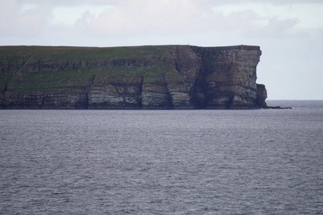
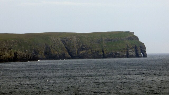
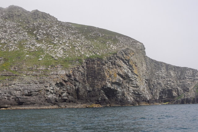
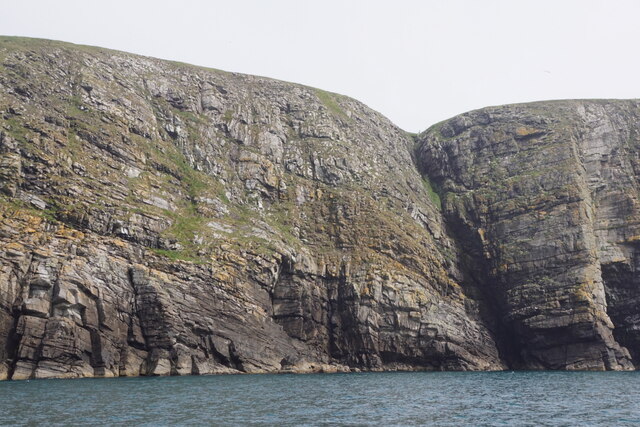
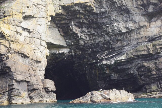
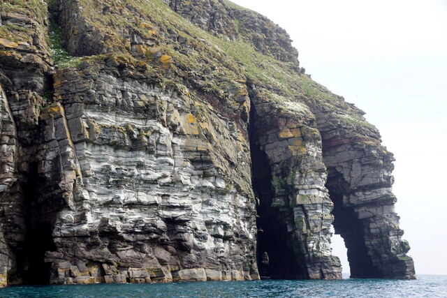
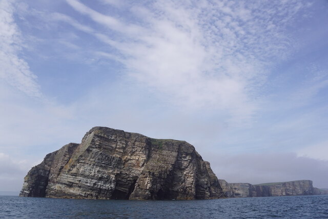
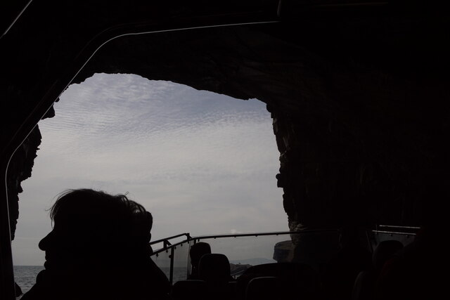
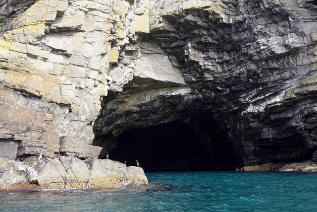
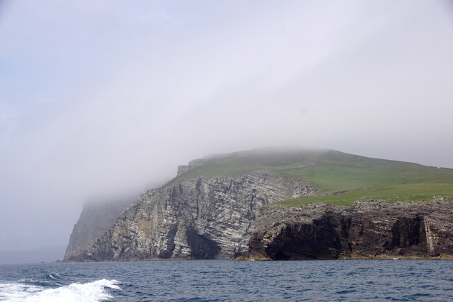
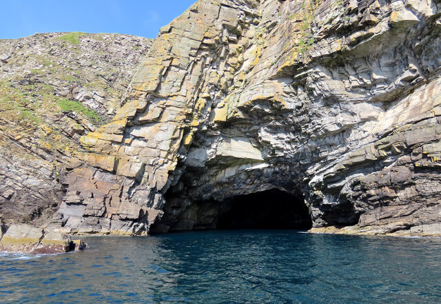
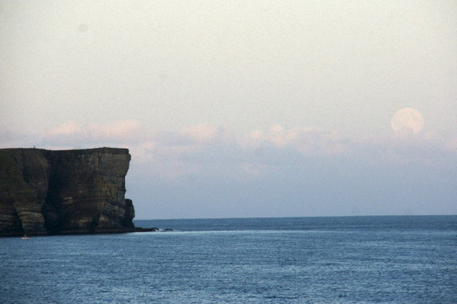
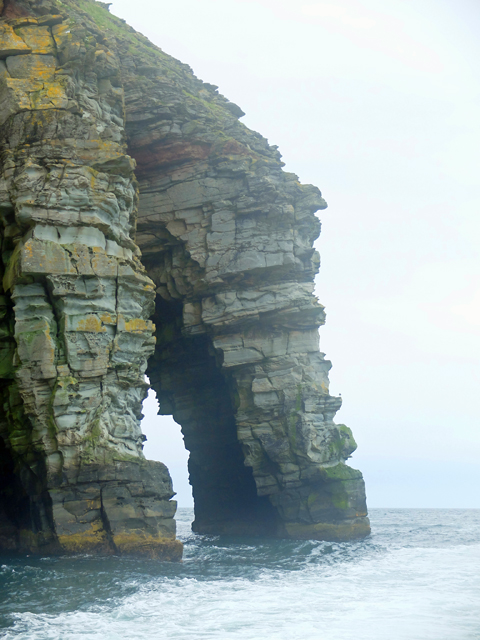
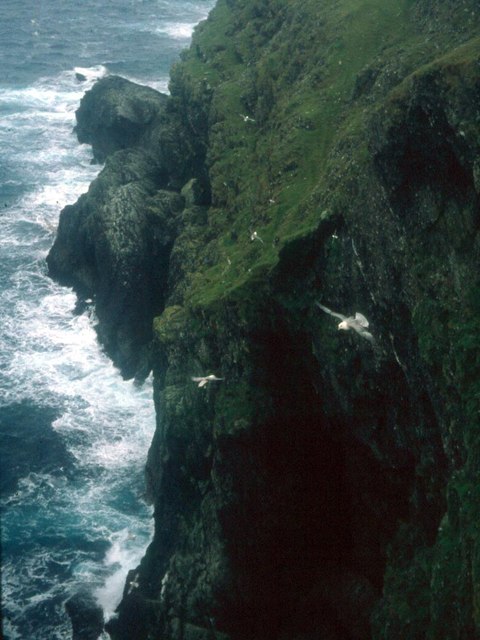
The headland of Bard is characterized by its rugged and rocky terrain, with steep cliffs that overlook the North Atlantic Ocean. These cliffs provide stunning views of the surrounding coastline and the nearby islands of Shetland. The area is abundant in natural beauty, with the crashing waves and the cries of seabirds creating a picturesque atmosphere.

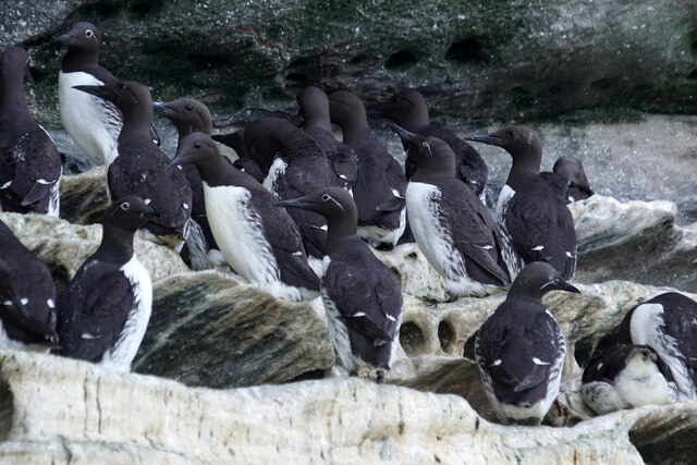
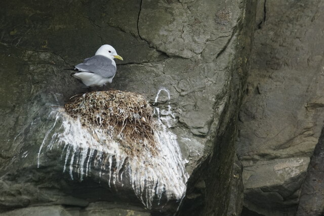
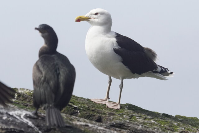
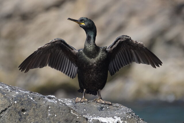
Bard is a popular destination for both locals and visitors alike, attracting hikers, nature enthusiasts, and photographers. It offers various walking trails that allow visitors to explore the headland and take in the breathtaking vistas. The headland is also home to an array of wildlife, including seabirds like puffins, guillemots, and fulmars, as well as seals that can often be spotted basking on the rocky shores.

Due to its position on the western coast, Bard is exposed to the elements, resulting in a windy and sometimes harsh climate. However, this only adds to the allure of the area, as it provides a sense of untamed beauty and a connection to the power of nature.

Overall, Bard in Shetland is a magnificent coastal feature that offers a captivating and rugged landscape, making it a must-visit destination for those seeking to experience the wild beauty of the Scottish coast.

If you have any feedback on the listing, please let us know in the comments section below.

Bard Images

Images are sourced within 2km of 60.106829/-1.0767186 or Grid Reference HU5136. Thanks to Geograph Open Source API. All images are credited.

Bard Head Taken from the Marco Polo cruise ship on the way out of Lerwick.
Bard Head
Taken from the Marco Polo cruise ship on the way out of Lerwick.
Bard Head View from the Lerwick to Aberdeen Ferry.
Bard Head
View from the Lerwick to Aberdeen Ferry.
Mills of the Ord, Bressay, from the sea
Coastline at the Orkneyman's Cave, the Bard, Bressay
Orkneyman's Cave, the Bard, Bressay Although labelled as the Cave of the Bard on OS maps, this is the name by which everyone in Shetland knows it.
Orkneyman's Cave, the Bard, Bressay
Although labelled as the Cave of the Bard on OS maps, this is the name by which everyone in Shetland knows it.
The Giant's Leg, The Bard, Bressay
Bard Head, Bressay, from the sea
In the Orkneyman's Cave, Bard Head, Bressay, looking out
Orkneyman's Cave, Bard Head, Bressay Labelled as Cave of the Bard on the map, but no-one locally uses that name.
Orkneyman's Cave, Bard Head, Bressay
Labelled as Cave of the Bard on the map, but no-one locally uses that name.
Mills of the Ord, Bressay, from the sea
Guillemot (Uria aalge), Bard Head, Bressay
Kittiwake (Rissa tridactyla), Bard Head, Bressay
Great Black-backed Gull (Larus marinus), Bard Head, Bressay
Shag (Gulusus aristotelis), Bard Head, Bressay
The Orkneyman's Cave, Bressay Known locally as the Orkneyman's Cave*, this is the Cave of the Bard on the headland of the same name, Bressay, Shetland.

*A popular myth is that this cave was used as a hiding place for a man from Orkney evading a press-gang; although his boat is said to have washed away in a storm, he managed to climb the cliffs onto Bressay and make his escape.
The Orkneyman's Cave, Bressay
Known locally as the Orkneyman's Cave*, this is the Cave of the Bard on the headland of the same name, Bressay, Shetland. *A popular myth is that this cave was used as a hiding place for a man from Orkney evading a press-gang; although his boat is said to have washed away in a storm, he managed to climb the cliffs onto Bressay and make his escape.
Bard Head, Bressay Taken from about 3.5 km to the west, from the Aberdeen ferry. A full moon is just rising.
Bard Head, Bressay
Taken from about 3.5 km to the west, from the Aberdeen ferry. A full moon is just rising.
The Giant's Leg A sea arch at the end of Bard Head, the most southerly point of Bressay.
The Giant's Leg
A sea arch at the end of Bard Head, the most southerly point of Bressay.
Fulmars wheel in the up-draught on the cliffs of Bressay
Show me another place!

Bard is located at Grid Ref: HU5136 (Lat: 60.106829, Lng: -1.0767186)

Unitary Authority: Shetland Islands

Police Authority: Highlands and Islands

What 3 Words

///pacifist.crisp.reacting. Near Lerwick, Shetland Islands

Related Wikis

Bressay transmitting station

Bressay transmitting station is a broadcasting transmission facility for the Shetland Islands, located on the isle of Bressay, owned and operated by Arqiva...

Holm of Noss

The Holm of Noss or Cradle Holm is an uninhabited islet of the Shetland Islands. It is about 48m at its highest point. == Geography and geology == It is...

Bressay

Bressay (Scots: Bressa) is a populated island in the Shetland archipelago of Scotland. == Geography and geology == Bressay lies due south of Whalsay, west...

Isle of Noss

The Isle of Noss or Noss (Scots: Noss) is a small, previously inhabited island in Shetland, Scotland. Noss is separated from the island of Bressay by the...

Lerwick and Bressay Parish Church

Lerwick and Bressay Parish Church is the largest Church of Scotland congregation in Shetland, serving the islands' capital Lerwick and the surrounding...

Broch of Cullingsburgh

The Broch of Cullingsburgh is an Iron Age broch located in the Shetland islands. == Location == Located on Bressay, off the east coast of mainland Shetland...

Gardie House

Gardie House is an 18th-century estate house on Bressay in Shetland, Scotland. Located opposite Lerwick, across the Bressay Sound, Gardie is described...

Voe of Cullingsburgh

Voe of Cullingsburgh is a large sea loch off the Shetland island of Bressay, voe meaning "sea inlet" in Shetland dialect. The local spelling of the name...

Nearby Amenities

Located within 500m of 60.106829,-1.0767186
Source: bing
Lat/Long: 60.1083129/-1.081973
Source: bing
Lat/Long: 60.1054894/-1.0789477
Source: bing
Lat/Long: 60.103047/-1.0741118
Source: bing
Lat/Long: 60.1049946/-1.0722673
Source: bing
Lat/Long: 60.1081888/-1.0756136
Source: bing
Lat/Long: 60.1026836/-1.0735509
Source: bing
Lat/Long: 60.1026915/-1.0734753
Source: bing
Lat/Long: 60.102757/-1.0739489
Source: bing
Lat/Long: 60.1027954/-1.072744
Source: bing
Lat/Long: 60.1027959/-1.0727769
Source: bing
Lat/Long: 60.1028105/-1.0741137
Source: bing
Lat/Long: 60.1028139/-1.0729251
Source: bing
Lat/Long: 60.1028172/-1.0727798
Source: bing
Lat/Long: 60.102839/-1.0728674
Source: bing
Lat/Long: 60.1028519/-1.0728037
Source: bing
Lat/Long: 60.102853/-1.0729739
Source: bing
Lat/Long: 60.1028619/-1.0729605
Source: bing
Lat/Long: 60.1028881/-1.0729806
Source: bing
Lat/Long: 60.1028947/-1.0730177
Source: bing
Lat/Long: 60.1029057/-1.0729399
Source: bing
Lat/Long: 60.1029081/-1.0730152
Source: bing
Lat/Long: 60.1029257/-1.0728444
Source: bing
Lat/Long: 60.1029347/-1.0757352
Source: bing
Lat/Long: 60.1029561/-1.0728189
Source: bing
Lat/Long: 60.1029659/-1.0741473
Source: bing
Lat/Long: 60.1029805/-1.0757
Source: bing
Lat/Long: 60.1029853/-1.0728341
Source: bing
Lat/Long: 60.1029873/-1.0728699
Source: bing
Lat/Long: 60.1029992/-1.0760897
Source: bing
Lat/Long: 60.1030111/-1.0728739
Source: bing
Lat/Long: 60.1030137/-1.0728212
Source: bing
Lat/Long: 60.1030191/-1.0757576
Source: bing
Lat/Long: 60.1030325/-1.0727536
Source: bing
Lat/Long: 60.1030583/-1.0726382
Source: bing
Lat/Long: 60.1030583/-1.0727556
Source: bing
Lat/Long: 60.1030629/-1.0757154
Source: bing
Lat/Long: 60.1030702/-1.07268
Source: bing
Lat/Long: 60.1030892/-1.0756676
Source: bing
Lat/Long: 60.1031038/-1.0747789
Source: bing
Lat/Long: 60.1031051/-1.0725584
Source: bing
Lat/Long: 60.1031239/-1.0747774
Source: bing
Lat/Long: 60.1031412/-1.0724595
Source: bing
Lat/Long: 60.1031479/-1.0759828
Source: bing
Lat/Long: 60.1031488/-1.0751006
Source: bing
Lat/Long: 60.1031549/-1.0748434
Source: bing
Lat/Long: 60.1031715/-1.0741228
Source: bing
Lat/Long: 60.1031727/-1.0756029
Source: bing
Lat/Long: 60.1031787/-1.0724938
Source: bing
Lat/Long: 60.1031854/-1.0748271
Source: bing
Lat/Long: 60.1032112/-1.0747813
Source: bing
Lat/Long: 60.1032152/-1.0763486
Source: bing
Lat/Long: 60.1032162/-1.0754045
Source: bing
Lat/Long: 60.1032382/-1.0724978
Source: bing
Lat/Long: 60.1032393/-1.0754819
Source: bing
Lat/Long: 60.1032404/-1.0764217
Source: bing
Lat/Long: 60.1032508/-1.0747853
Source: bing
Lat/Long: 60.103254/-1.0755199
Source: bing
Lat/Long: 60.1032582/-1.0754214
Source: bing
Lat/Long: 60.103265/-1.0724362
Source: bing
Lat/Long: 60.1032652/-1.075503
Source: bing
Lat/Long: 60.1032773/-1.0742945
Source: bing
Lat/Long: 60.1032878/-1.0724799
Source: bing
Lat/Long: 60.1032892/-1.0740995
Source: bing
Lat/Long: 60.1032994/-1.0764161
Source: bing
Lat/Long: 60.1033065/-1.0763056
Source: bing
Lat/Long: 60.1033163/-1.0745545
Source: bing
Lat/Long: 60.1033363/-1.0762698
Source: bing
Lat/Long: 60.1033384/-1.0724819
Source: bing
Lat/Long: 60.1033504/-1.0724357
Source: bing
Lat/Long: 60.1033645/-1.0747282
Source: bing
Lat/Long: 60.1033711/-1.0722738
Source: bing
Lat/Long: 60.103376/-1.0720931
Source: bing
Lat/Long: 60.103388/-1.0765738
Source: bing
Lat/Long: 60.1033949/-1.0719973
Source: bing
Lat/Long: 60.1034018/-1.0721007
Source: bing
Lat/Long: 60.1034117/-1.0718583
Source: bing
Lat/Long: 60.1034415/-1.071864
Source: bing
Lat/Long: 60.1034712/-1.0719873
Source: bing
Lat/Long: 60.1034822/-1.0719316
Source: bing
Lat/Long: 60.1034921/-1.0720211
Source: bing
Lat/Long: 60.1035208/-1.0720192
Source: bing
Lat/Long: 60.1035209/-1.0769901
Source: bing
Lat/Long: 60.1035327/-1.0719754
Source: bing
Lat/Long: 60.1035369/-1.0717393
Source: bing
Lat/Long: 60.10357/-1.071585
Source: bing
Lat/Long: 60.103591/-1.0718494
Source: bing
Lat/Long: 60.1035995/-1.0716609
Source: bing
Lat/Long: 60.1036443/-1.0772433
Source: bing
Lat/Long: 60.1036948/-1.0719732
Source: bing
Lat/Long: 60.1037129/-1.0772272
Source: bing
Lat/Long: 60.1037286/-1.0718756
Source: bing
Lat/Long: 60.1038082/-1.0772835
Source: bing
Lat/Long: 60.1038251/-1.0773848
Source: bing
Lat/Long: 60.1038701/-1.0720548
Source: bing
Lat/Long: 60.103993/-1.0721415
Source: bing
Lat/Long: 60.1041504/-1.0776774
Source: bing
Lat/Long: 60.1042315/-1.0776455
Source: bing
Lat/Long: 60.1042468/-1.072428
Source: bing
Lat/Long: 60.1044095/-1.0726665
Source: bing
Lat/Long: 60.1045041/-1.0728171
Source: bing
Lat/Long: 60.1045602/-1.0729927
Source: bing
Lat/Long: 60.1045711/-1.0779739
Source: bing
Lat/Long: 60.1046104/-1.0778501
Source: bing
Lat/Long: 60.1046192/-1.0730081
Source: bing
Lat/Long: 60.104637/-1.0729007
Source: bing
Lat/Long: 60.1046384/-1.0780302
Source: bing
Lat/Long: 60.1047302/-1.0729246
Source: bing
Lat/Long: 60.1047481/-1.0728768
Source: bing
Lat/Long: 60.1048135/-1.0728808
Source: bing
Lat/Long: 60.1048294/-1.072662
Source: bing
Lat/Long: 60.1048294/-1.0727853
Source: bing
Lat/Long: 60.1048532/-1.0725824
Source: bing
Lat/Long: 60.1049404/-1.0724909
Source: bing
Lat/Long: 60.1050674/-1.0724272
Source: bing
Lat/Long: 60.1050872/-1.0783059
Source: bing
Lat/Long: 60.1051408/-1.0724351
Source: bing
Lat/Long: 60.1052221/-1.0725545
Source: bing
Lat/Long: 60.1053144/-1.078257
Source: bing
Lat/Long: 60.1053549/-1.0726182
Source: bing
Lat/Long: 60.1054025/-1.0726699
Source: bing
Lat/Long: 60.1054323/-1.0727614
Source: bing
Lat/Long: 60.1054361/-1.0788419
Source: bing
Lat/Long: 60.1054585/-1.0783298
Source: bing
Lat/Long: 60.1055017/-1.0727933
Source: bing
Lat/Long: 60.1055017/-1.072845
Source: bing
Lat/Long: 60.1055604/-1.0788727
Source: bing
Lat/Long: 60.1056028/-1.0729445
Source: bing
Lat/Long: 60.1056263/-1.0787376
Source: bing
Lat/Long: 60.1056378/-1.0788995
Source: bing
Lat/Long: 60.1056434/-1.0792512
Source: bing
Lat/Long: 60.105771/-1.0730047
Source: bing
Lat/Long: 60.1058036/-1.0730999
Source: bing
Lat/Long: 60.1058493/-1.0732825
Source: bing
Lat/Long: 60.1058535/-1.0734176
Source: bing
Lat/Long: 60.1058661/-1.0733979
Source: bing
Lat/Long: 60.1059407/-1.0794876
Source: bing
Lat/Long: 60.1059537/-1.0737996
Source: bing
Lat/Long: 60.1059553/-1.0738424
Source: bing
Lat/Long: 60.1059688/-1.0798815
Source: bing
Lat/Long: 60.105994/-1.0737648
Source: bing
Lat/Long: 60.1060019/-1.0737867
Source: bing
Lat/Long: 60.1060128/-1.0738961
Source: bing
Lat/Long: 60.1061219/-1.0739439
Source: bing
Lat/Long: 60.1061368/-1.0738384
Source: bing
Lat/Long: 60.1061834/-1.0738484
Source: bing
Lat/Long: 60.1061931/-1.0805793
Source: bing
Lat/Long: 60.1061933/-1.073926
Source: bing
Lat/Long: 60.1062458/-1.0739359
Source: bing
Lat/Long: 60.1062815/-1.0739936
Source: bing
Lat/Long: 60.1063678/-1.0740195
Source: bing
Lat/Long: 60.1063693/-1.0808666
Source: bing
Lat/Long: 60.1064035/-1.0740453
Source: bing
Lat/Long: 60.1064982/-1.0805007
Source: bing
Lat/Long: 60.1065731/-1.074091
Source: bing
Lat/Long: 60.1065802/-1.0813221
Source: bing
Lat/Long: 60.1065858/-1.0806918
Source: bing
Lat/Long: 60.1066224/-1.0740057
Source: bing
Lat/Long: 60.1066238/-1.0741774
Source: bing
Lat/Long: 60.1066363/-1.0810745
Source: bing
Lat/Long: 60.1066392/-1.0740789
Source: bing
Lat/Long: 60.1066827/-1.0741914
Source: bing
Lat/Long: 60.1067135/-1.0741464
Source: bing
Lat/Long: 60.1067766/-1.0741127
Source: bing
Lat/Long: 60.1068775/-1.0813784
Source: bing
Lat/Long: 60.1070571/-1.074273
Source: bing
Lat/Long: 60.1070599/-1.0743884
Source: bing
Lat/Long: 60.1070626/-1.0815247
Source: bing
Lat/Long: 60.107085/-1.0817498
Source: bing
Lat/Long: 60.1071272/-1.0744306
Source: bing
Lat/Long: 60.1071523/-1.0815697
Source: bing
Lat/Long: 60.1071987/-1.0743828
Source: bing
Lat/Long: 60.1072028/-1.0817948
Source: bing
Lat/Long: 60.1072548/-1.0742421
Source: bing
Lat/Long: 60.1072645/-1.081626
Source: bing
Lat/Long: 60.1074002/-1.0820223
Source: bing
Lat/Long: 60.1076991/-1.0744763
Source: bing
Lat/Long: 60.1077619/-1.0820485
Source: bing
Lat/Long: 60.1077877/-1.081941
Source: bing
Lat/Long: 60.1078003/-1.0747457
Source: bing
Lat/Long: 60.1079139/-1.0749568
Source: bing
Lat/Long: 60.1079246/-1.0818455
Source: bing
Lat/Long: 60.1079798/-1.0751847
Source: bing
Lat/Long: 60.1080416/-1.0818495
Source: bing
Lat/Long: 60.1080611/-1.0752972
Source: bing
Lat/Long: 60.1081656/-1.0737965
Source: bing
Lat/Long: 60.1081665/-1.0820604
Source: bing
Lat/Long: 60.108255/-1.0757643
Source: bing
Lat/Long: 60.108283/-1.0738397
Source: bing
Lat/Long: 60.1083326/-1.0818822
Source: bing
Lat/Long: 60.1083746/-1.0819892
Source: bing
Lat/Long: 60.1084008/-1.0755054
Source: bing
Lat/Long: 60.1084064/-1.0742449
Source: bing
Lat/Long: 60.1084307/-1.0817641
Source: bing
Lat/Long: 60.1084513/-1.0746951
Source: bing
Lat/Long: 60.1084644/-1.0821636
Source: bing
Lat/Long: 60.1084793/-1.0752803
Source: bing
Lat/Long: 60.108484/-1.0818879
Source: bing
Lat/Long: 60.1085133/-1.0743315
Source: bing
Lat/Long: 60.1085747/-1.0747739
Source: bing
Lat/Long: 60.1086455/-1.0741865
Source: bing
Lat/Long: 60.1086719/-1.0739655
Source: bing
Lat/Long: 60.1086742/-1.0751506
Source: bing
Lat/Long: 60.1087112/-1.0823212
Source: bing
Lat/Long: 60.1088037/-1.0822536
Source: bing
Lat/Long: 60.1089636/-1.0823493
Source: bing
Lat/Long: 60.1090337/-1.0832159
Source: bing
Lat/Long: 60.1090505/-1.0825688
Source: bing
Lat/Long: 60.1090561/-1.0833622
Source: bing
Lat/Long: 60.1090898/-1.0828333
Source: bing
Lat/Long: 60.1090954/-1.0831878
Source: bing
Lat/Long: 60.1091178/-1.0825069
Source: bing
Lat/Long: 60.1091374/-1.0835536
Source: bing
Lat/Long: 60.1091655/-1.0833228
Source: bing
Lat/Long: 60.1091711/-1.0823774
Source: bing
Lat/Long: 60.1091935/-1.0827826
Source: bing
Lat/Long: 60.1091991/-1.0835648
Source: bing
Lat/Long: 60.109244/-1.0824056
Source: bing
Lat/Long: 60.109244/-1.083064
Source: bing
Lat/Long: 60.1092487/-1.0842771
Source: bing
Lat/Long: 60.1092491/-1.0839002
Source: bing
Lat/Long: 60.1092496/-1.083351
Source: bing
Lat/Long: 60.1092782/-1.0842208
Source: bing
Lat/Long: 60.1092901/-1.0840859
Source: bing
Lat/Long: 60.1093085/-1.0830302
Source: bing
Lat/Long: 60.1093205/-1.0837967
Source: bing
Lat/Long: 60.1093337/-1.0828501
Source: bing
Lat/Long: 60.1093342/-1.0744748
Source: bing
Lat/Long: 60.1093806/-1.0836595
Source: bing
Lat/Long: 60.1093898/-1.0832047
Source: bing
Lat/Long: 60.1093982/-1.0828164
Source: bing
Lat/Long: 60.1094459/-1.0825519
Source: bing
Lat/Long: 60.1094487/-1.0822987
Source: bing
Lat/Long: 60.1094824/-1.0822199
Source: bing
Lat/Long: 60.1094831/-1.0836495
Source: bing
Lat/Long: 60.1094989/-1.0838007
Source: bing
Lat/Long: 60.1095011/-1.0833629
Source: bing
Lat/Long: 60.1095049/-1.0834744
Source: bing
Lat/Long: 60.1095497/-1.0822311
Source: bing
Lat/Long: 60.1095525/-1.0832328
Source: bing
Lat/Long: 60.1095881/-1.0746737
Source: bing
Lat/Long: 60.1096254/-1.082158
Source: bing
Lat/Long: 60.109631/-1.082293
Source: bing
Lat/Long: 60.1096534/-1.0832441
Source: bing
Lat/Long: 60.1096619/-1.0834185
Source: bing
Lat/Long: 60.1099384/-1.0729609
Source: bing
Lat/Long: 60.1099909/-1.0739622
Source: bing
Lat/Long: 60.11006/-1.073106
Source: bing
Lat/Long: 60.1101248/-1.0747993
Source: bing
Lat/Long: 60.1105641/-1.0730532
Source: bing
Lat/Long: 60.110009/-1.0741798
Source: bing
Lat/Long: 60.1100371/-1.0743655
Source: bing
Lat/Long: 60.1100735/-1.0743486
Source: bing
Lat/Long: 60.1100876/-1.0746244
Source: bing
Lat/Long: 60.110124/-1.0746863
Source: bing
Lat/Long: 60.1101549/-1.0745737
Source: bing
Lat/Long: 60.1104185/-1.0730375
Source: bing
Lat/Long: 60.110525/-1.0729868
Coastal Defence Gun
Tourism: information
Lat/Long: 60.1034303/-1.072669
Source: bing
Lat/Long: 60.1097986/-1.0818422
The Giant's Leg
Natural: cave_entrance
Lat/Long: 60.1030879/-1.0758126
Orkneyman's Cave
Natural: cave_entrance
Lat/Long: 60.1054535/-1.078444
The data included in this document is from www.openstreetmap.org. The data is made available under ODbL.

Have you been to Bard?

Leave your review of Bard below (or comments, questions and feedback).