Black Jack

Coastal Feature, Headland, Point in Angus

Scotland

Black Jack

North End of Lunan Beach Tide was on its way in, and a very blustery day whipping up the surf. In the distance on the RHS are The Limekilns at Boddin.
North End of Lunan Beach Credit: Jacqueline Hamilton

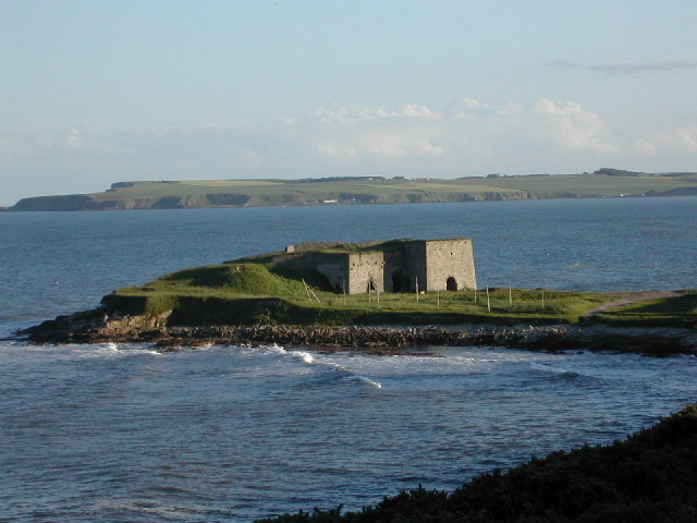
Black Jack, Angus is a prominent coastal feature located in the county of Angus, Scotland. It is classified as a headland or point and is known for its stunning natural beauty and historical significance.

Situated on the eastern coast of Scotland, Black Jack stands tall and proud, jutting out into the North Sea. It is characterized by its rugged cliffs, which are composed of sedimentary rocks, including sandstone and shale. These cliffs provide a dramatic backdrop to the surrounding landscape and offer breathtaking views of the sea and the surrounding coastline.

The headland gets its name from the dark color of the rocks, which appear almost black in certain lighting conditions. This unique geological feature adds to the allure of Black Jack, making it a popular destination for nature lovers, hikers, and photographers.

In addition to its natural beauty, Black Jack also holds historical significance. It is believed to have been a strategic lookout point during ancient times, offering a vantage point to observe incoming ships and potential threats. Numerous archaeological discoveries have been made in the vicinity, including remnants of ancient settlements and artifacts.

Today, Black Jack attracts visitors from all over the world who come to appreciate its natural splendor and explore its historical heritage. It offers opportunities for coastal walks, birdwatching, and rock climbing, making it a haven for outdoor enthusiasts. Whether one is drawn to its geological wonders or its historical importance, Black Jack, Angus, is a captivating coastal feature that showcases the beauty and heritage of the Scottish coastline.

If you have any feedback on the listing, please let us know in the comments section below.

Black Jack Images

Images are sourced within 2km of 56.672835/-2.4749356 or Grid Reference NO7053. Thanks to Geograph Open Source API. All images are credited.

North End of Lunan Beach Tide was on its way in, and a very blustery day whipping up the surf. In the distance on the RHS are The Limekilns at Boddin.
North End of Lunan Beach
Tide was on its way in, and a very blustery day whipping up the surf. In the distance on the RHS are The Limekilns at Boddin.
Dysart Fields Fields by Upper Dysart.
Dysart Fields
Fields by Upper Dysart.
Road passing Nether Dysart Road passing Nether Dysart heading towards Lunan
Road passing Nether Dysart
Road passing Nether Dysart heading towards Lunan
Natural Arch One of many arches in the cliffs both north and south of Lunan Bay.
Natural Arch
One of many arches in the cliffs both north and south of Lunan Bay.
Buckie Den 'Den' is the Scots term for a deep narrow glen. This one is spanned by the main east coast railway to and from Aberdeen. The seaward end of the den is covered by a profusion of wild flowers, though it has to be admitted that many of them are invasive aliens, like Himalayan Balsam.
Buckie Den
'Den' is the Scots term for a deep narrow glen. This one is spanned by the main east coast railway to and from Aberdeen. The seaward end of the den is covered by a profusion of wild flowers, though it has to be admitted that many of them are invasive aliens, like Himalayan Balsam.
Nether Dysart Straw bales waiting to be collected at Nether Dysart Farm.
Nether Dysart
Straw bales waiting to be collected at Nether Dysart Farm.
Looking towards Upper Dysart Upper Dysart itself is in the next square, but all the stubble fields in the foreground are in this square. The yellow lorry on the left is on the A92, which passes along the far edge of the second field.
Looking towards Upper Dysart
Upper Dysart itself is in the next square, but all the stubble fields in the foreground are in this square. The yellow lorry on the left is on the A92, which passes along the far edge of the second field.
Whiteinn The house on the far side of the fields is marked as Whiteinn on the map. It stands beside the A92, and was probably originally the site of an inn used by travellers between Arbroath and Montrose. The present house is modern.
Whiteinn
The house on the far side of the fields is marked as Whiteinn on the map. It stands beside the A92, and was probably originally the site of an inn used by travellers between Arbroath and Montrose. The present house is modern.
Moon Jellyfish on Lunan Bay Beach, Angus This photo of a Moon Jellyfish (Aurelia aurita) was taken at a short distance from it and from almost directly above. Although large numbers of them can be stranded on the beach, often near the mouth of the River Lunan, this particular specimen was on its own. They are plankton feeders and have a mild, harmless sting. The distinctive four coloured gonads can be seen in this photo.
Moon Jellyfish on Lunan Bay Beach, Angus
This photo of a Moon Jellyfish (Aurelia aurita) was taken at a short distance from it and from almost directly above. Although large numbers of them can be stranded on the beach, often near the mouth of the River Lunan, this particular specimen was on its own. They are plankton feeders and have a mild, harmless sting. The distinctive four coloured gonads can be seen in this photo.
Cave in cliffs at Lunan Bay This cave has two entrances. It is positioned near the junction of the cliffs and the sandy beach at Lunan Bay.
Cave in cliffs at Lunan Bay
This cave has two entrances. It is positioned near the junction of the cliffs and the sandy beach at Lunan Bay.
Railway bridge, Braehead of Lunan On the East Coast Main Line.
Railway bridge, Braehead of Lunan
On the East Coast Main Line.
Nether Dysart
Nether Dysart
Crop field, Nether Dysart
National Cycle Route 1 heading north  At Nether Dysart.
National Cycle Route 1 heading north
At Nether Dysart.
Farmland towards East Mains of Dysart
Country road towards Ferryden
Salmon nets below cliffs at Lunan
Whelks I'm bound to get into a muddle over what these are. We always called them whelks, in contrast to the edible gastropods we call buckies (Littorina littorea). However I know that the edible ones are widely referred to as whelks or wulks or winkles, and the term buckie is applied to different gastropods in different places. Anyway, I think these are one of a number of species called dog whelks (Nucella lapillus). They are very common, but don't usually pack themselves quite so tightly together.
Whelks
I'm bound to get into a muddle over what these are. We always called them whelks, in contrast to the edible gastropods we call buckies (Littorina littorea). However I know that the edible ones are widely referred to as whelks or wulks or winkles, and the term buckie is applied to different gastropods in different places. Anyway, I think these are one of a number of species called dog whelks (Nucella lapillus). They are very common, but don't usually pack themselves quite so tightly together.
Show me another place!

Black Jack is located at Grid Ref: NO7053 (Lat: 56.672835, Lng: -2.4749356)

Unitary Authority: Angus

Police Authority: Tayside

What 3 Words

///wrong.cherish.sheepish. Near Montrose, Angus

Nearby Locations

Rickle Craig Black Jack

Related Wikis

Boddin, Angus

Boddin is a coastal village in Angus, Scotland, two miles south of Montrose. There are lime kilns at Boddin Point. == References ==

Ferryden

Ferryden is a village in Angus, Scotland in the community council area of Ferryden & Craig. It lies southerly adjacent to the town of Montrose on the south...

Lunan Bay railway station

Lunan Bay railway station served the village of Lunan, Angus, Scotland from 1883 to 1964 on the North British, Arbroath and Montrose Railway. == History... ==

Lunan Water

The Lunan Water is an easterly flowing river in Angus, Scotland, that discharges to the North Sea 11 kilometres (6.8 mi) north of the town of Arbroath...

Lunan, Angus

Lunan is a hamlet in Angus, Scotland, in the parish of the same name, 6 kilometres (3.7 mi) south of Montrose. The hamlet overlooks Lunan Bay, which is...

Arbikie distillery

Arbikie distillery is a scotch whisky, vodka and gin distillery in Inverkeilor, Angus, Scotland. == History == The distillery was built in 2013 on the...

Red Castle, Angus

Red Castle of Lunan is a ruined fortified house on the coast of Angus, Scotland. It is about 4 miles (6.4 km) south-southwest of Montrose. == History... ==

Montrose Royal Infirmary

Montrose Royal Infirmary was a health facility in Bridge Street, Montrose, Angus, Scotland. It was managed by NHS Tayside. It is a Category A listed building...

Nearby Amenities

Located within 500m of 56.672835,-2.4749356
Source: PGS
Lat/Long: 56.6715322/-2.4827095
Source: PGS
Lat/Long: 56.6717092/-2.4815749
Source: PGS
Lat/Long: 56.6717037/-2.4811387
Source: PGS
Lat/Long: 56.6719987/-2.4808572
Source: PGS
Lat/Long: 56.6723003/-2.4809085
Source: PGS
Lat/Long: 56.6723283/-2.479096
Created By: almien_coastlines
Source: PGS
Lat/Long: 56.672288/-2.477423
Created By: almien_coastlines
Source: PGS
Lat/Long: 56.672286/-2.476958
Source: PGS
Lat/Long: 56.6721822/-2.4764479
Created By: almien_coastlines
Source: PGS
Lat/Long: 56.672278/-2.475098
Source: PGS
Lat/Long: 56.672272/-2.4742297
Source: PGS
Lat/Long: 56.6725704/-2.4727039
Source: PGS
Lat/Long: 56.6724686/-2.4727212
Source: PGS
Lat/Long: 56.6724771/-2.4710933
Source: PGS
Lat/Long: 56.6721745/-2.4707669
Source: PGS
Lat/Long: 56.6719978/-2.4706493
Source: PGS
Lat/Long: 56.6718448/-2.4705271
Source: PGS
Lat/Long: 56.6717327/-2.4705098
Boddin
Place: hamlet
Wikidata: Q4936413
Wikipedia: en:Boddin, Angus
Lat/Long: 56.6728711/-2.4713642
Lunan Bay
Natural: bay
Lat/Long: 56.6711813/-2.477584
Power: pole
Lat/Long: 56.6728372/-2.4706925
Power: pole
Lat/Long: 56.6734131/-2.4709524
Power: pole
Lat/Long: 56.6738961/-2.4711581
Power: pole
Lat/Long: 56.6744934/-2.471431
Power: pole
Lat/Long: 56.674792/-2.4720222
Power: pole
Lat/Long: 56.6752012/-2.4731829
Power: pole
Lat/Long: 56.6755879/-2.4738802
Power: pole
Lat/Long: 56.6757521/-2.4741682
Power: pole
Lat/Long: 56.6762541/-2.4750993
Power: pole
Lat/Long: 56.6767252/-2.475998
Power: pole
Lat/Long: 56.6771987/-2.4768946
The data included in this document is from www.openstreetmap.org. The data is made available under ODbL.

Have you been to Black Jack?

Leave your review of Black Jack below (or comments, questions and feedback).