Garmelow

Settlement in Staffordshire Stafford

England

Garmelow

The Star Inn The Starr Inn is at Copmere End which is a location where five minor roads converge and is part of a complex of other minor roads with dispersed settlement near to Eccleshall.
The Star Inn Credit: Trevor Littlewood

Garmelow is a small village located in the county of Staffordshire, England. It is situated approximately 4 miles northeast of the town of Newcastle-under-Lyme and 6 miles northwest of the city of Stoke-on-Trent. Garmelow is part of the borough of Newcastle-under-Lyme and falls within the civil parish of Keele.

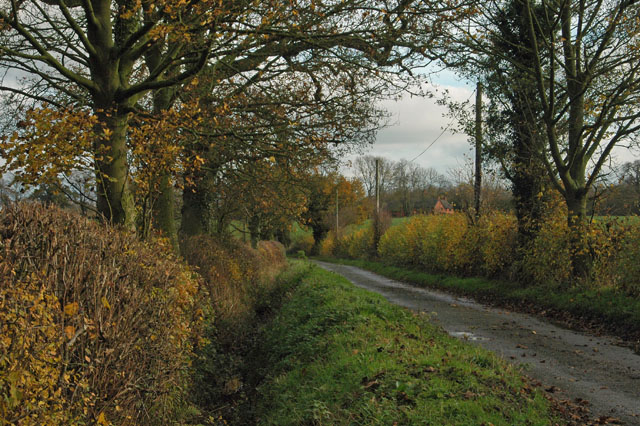
The village is known for its picturesque rural setting, surrounded by rolling hills and agricultural fields. It consists of a cluster of traditional stone houses, some of which date back several centuries, giving it a charming and historic atmosphere. The village is characterized by its tranquil and peaceful ambiance, making it an ideal place for those seeking a quiet and idyllic countryside retreat.

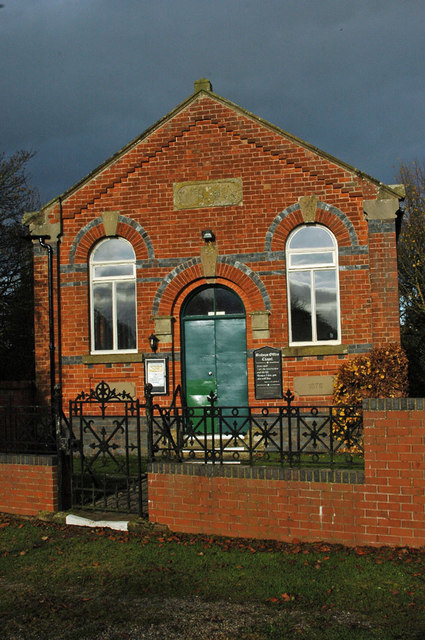
Despite its small size, Garmelow offers a sense of community with a local pub, The Old Swan, serving as a gathering place for residents and visitors alike. The pub provides a warm and friendly atmosphere, offering traditional food and beverages.

The village is conveniently located near several amenities and attractions. The nearby town of Newcastle-under-Lyme provides easy access to shopping centers, supermarkets, and various recreational facilities. Additionally, the Keele University campus is just a short distance away, offering educational and cultural opportunities.

Garmelow's location offers easy access to major transportation routes, including the A525 road, providing connections to nearby towns and cities. The village also benefits from a regular bus service, ensuring convenient travel options for residents.

Overall, Garmelow is a charming and peaceful village, providing a tranquil retreat in the heart of the Staffordshire countryside.

If you have any feedback on the listing, please let us know in the comments section below.

Garmelow Images

Images are sourced within 2km of 52.846392/-2.304353 or Grid Reference SJ7927. Thanks to Geograph Open Source API. All images are credited.

The Star Inn The Starr Inn is at Copmere End which is a location where five minor roads converge and is part of a complex of other minor roads with dispersed settlement near to Eccleshall.
The Star Inn
The Starr Inn is at Copmere End which is a location where five minor roads converge and is part of a complex of other minor roads with dispersed settlement near to Eccleshall.
Leafy lane
Leafy lane
The chapel at Offleymarsh
Country lane as it was getting dark Using an ISO 1600 the scene was much darker than it appears.
Country lane as it was getting dark
Using an ISO 1600 the scene was much darker than it appears.
Lane through Garmelow
Field at Windsend
Field at Windsend
Farmland north of High Offley, Staffordshire The public footpath across fields towards Bishops Offley is well marked by the farmer here.
Farmland north of High Offley, Staffordshire
The public footpath across fields towards Bishops Offley is well marked by the farmer here.
Farmland north of High Offley, Staffordshire The public footpath across fields towards Bishops Offley is well marked by the farmer here.
Farmland north of High Offley, Staffordshire
The public footpath across fields towards Bishops Offley is well marked by the farmer here.
Windows in the Church of St Mary the Virgin, High Offley The Church of St Mary in High Offley is Grade I listed, 12th to 15th century with 19th century restoration.
<span class="nowrap"><a title="https://historicengland.org.uk/listing/the-list/list-entry/1242831?section=official-list-" rel="nofollow ugc noopener" href="https://historicengland.org.uk/listing/the-list/list-entry/1242831?section=official-list-">Link</a><img style="margin-left:2px;" alt="External link" title="External link - shift click to open in new window" src="https://s1.geograph.org.uk/img/external.png" width="10" height="10"/></span>

It has several very attractive and colourful stained glass windows.
This set of three depicts the Ascension.

...While he blessed them, he parted from them and was carried up into heaven (and they worshipped him and returned to Jerusalem with great joy...) (Luke 24:51-52)
Windows in the Church of St Mary the Virgin, High Offley
The Church of St Mary in High Offley is Grade I listed, 12th to 15th century with 19th century restoration. LinkExternal link It has several very attractive and colourful stained glass windows. This set of three depicts the Ascension. ...While he blessed them, he parted from them and was carried up into heaven (and they worshipped him and returned to Jerusalem with great joy...) (Luke 24:51-52)
Church tower in High Offley, Staffordshire Looking south from the road near the junction with Wells Lane. The war memorial is in St Mary's Church yard.
Church tower in High Offley, Staffordshire
Looking south from the road near the junction with Wells Lane. The war memorial is in St Mary's Church yard.
St Mary's Church tower (detail) in High Offley Looking a little west of south from the road near Wells Lane junction.
St Mary's Church tower (detail) in High Offley
Looking a little west of south from the road near Wells Lane junction.
Farmland by Wells Lane north of High Offley Looking north, Wells Lane meanders eventually towards Eccleshall about three and a half miles away.
Farmland by Wells Lane north of High Offley
Looking north, Wells Lane meanders eventually towards Eccleshall about three and a half miles away.
Staffordshire farmland north of High Offley Seen by looking north-north-east from Wells Lane.
Staffordshire farmland north of High Offley
Seen by looking north-north-east from Wells Lane.
Staffordshire barley field north-west of High Offley Looking north-west from the stile by Wells Lane. The public footpath to Bishops Offley crosses this field.
Staffordshire barley field north-west of High Offley
Looking north-west from the stile by Wells Lane. The public footpath to Bishops Offley crosses this field.
Farmland north of High Offley in Staffordshire Looking north-north-east, this barley field is by Wells Lane (behind the hedge off to the right).
Farmland north of High Offley in Staffordshire
Looking north-north-east, this barley field is by Wells Lane (behind the hedge off to the right).
Barley field north of High Offley in Staffordshire The telephoto assisted image shows the scene looking north from the public footpath near the stile by Wells Lane.
Barley field north of High Offley in Staffordshire
The telephoto assisted image shows the scene looking north from the public footpath near the stile by Wells Lane.
Church of St Mary in High Offley, Staffordshire Seen from the south-west. A public footpath passes through the graveyard. The church is Grade I listed, 12th to 15th century with 19th century restoration.
<span class="nowrap"><a title="https://historicengland.org.uk/listing/the-list/list-entry/1242831?section=official-list-entry" rel="nofollow ugc noopener" href="https://historicengland.org.uk/listing/the-list/list-entry/1242831?section=official-list-entry">Link</a><img style="margin-left:2px;" alt="External link" title="External link - shift click to open in new window" src="https://s1.geograph.org.uk/img/external.png" width="10" height="10"/></span>
Church of St Mary in High Offley, Staffordshire
Seen from the south-west. A public footpath passes through the graveyard. The church is Grade I listed, 12th to 15th century with 19th century restoration. LinkExternal link
Show me another place!

Garmelow is located at Grid Ref: SJ7927 (Lat: 52.846392, Lng: -2.304353)

Administrative County: Staffordshire

District: Stafford

Police Authority: Staffordshire

What 3 Words

///shepherds.doghouse.ejects. Near Eccleshall, Staffordshire

Nearby Locations

Garmelow

Related Wikis

Copmere End

Copmere End is a small settlement in Staffordshire, England. It is 2 kilometres (1 mi) west of Eccleshall where the population taken for the 2011 census...

Offleyhay

Offleyhay is a village in Staffordshire, England. The population as taken at the 2011 census can be found under Eccleshall. == References ==

High Offley

High Offley is a small village and civil parish in Staffordshire, England. It lies 3 miles southwest of the small town of Eccleshall and about 1 mile west...

Cop Mere

Cop Mere is one of the largest natural bodies of water in Staffordshire, England, covering 42 acres (17 ha). It has been designated a SSSI as an oligotrophic...

Woodseaves

Woodseaves is a village in Staffordshire, England. It lies in the civil parish of High Offley and is situated on the A519 (Newport-Newcastle-under-Lyme...

Jackson's Coppice and Marsh

Jackson's Coppice and Marsh is a nature reserve of the Staffordshire Wildlife Trust. It is along the River Sow, near the village of Bishop's Offley and...

Tunstall, Stafford

Tunstall is a hamlet near Eccleshall in the borough of Stafford in Staffordshire, England. In 1870–72 it had a population of 72. Tunstall was recorded...

Knightley, Staffordshire

Knightley is a hamlet and former manor in Staffordshire, England. It is situated near the villages of Gnosall and Woodseaves, now on the B5405 road. There...

Nearby Amenities

Located within 500m of 52.846392,-2.304353
Bus Stop
Corner House
Bus: yes
Naptan AtcoCode: 3800C721600
Naptan Bearing: NW
Naptan CommonName: Corner House
Naptan Indicator: Adj
Naptan Landmark: Corner House
Naptan Street: Cash Lane
Naptan Verified: no
Public Transport: platform
Source: naptan_import
Lat/Long: 52.8484429/-2.3031251
Barrier: yes
Lat/Long: 52.8467805/-2.298325
Power: pole
Lat/Long: 52.8507205/-2.3054519
Power: pole
Lat/Long: 52.8497476/-2.305494
Power: pole
Lat/Long: 52.8489353/-2.3055313
Power: pole
Lat/Long: 52.8480822/-2.3051811
Power: pole
Lat/Long: 52.8477212/-2.3059236
Power: pole
Lat/Long: 52.8472276/-2.306888
Power: pole
Lat/Long: 52.8466226/-2.3080368
Power: pole
Lat/Long: 52.8463053/-2.3086159
Give Way
Direction: forward
Lat/Long: 52.8484661/-2.3029343
Give Way
Direction: backward
Lat/Long: 52.8484686/-2.3030376
Give Way
Direction: backward
Lat/Long: 52.8486211/-2.3028124
Give Way
Direction: forward
Lat/Long: 52.8485122/-2.3027175
The data included in this document is from www.openstreetmap.org. The data is made available under ODbL.

Have you been to Garmelow?

Leave your review of Garmelow below (or comments, questions and feedback).