Garlinge

Settlement in Kent Thanet

England

Garlinge

Arlington House Arlington House seen from the exit of Margate railway station. Built in 1964 as luxury apartments in the brutalist style.
Arlington House Credit: Daniel Parks

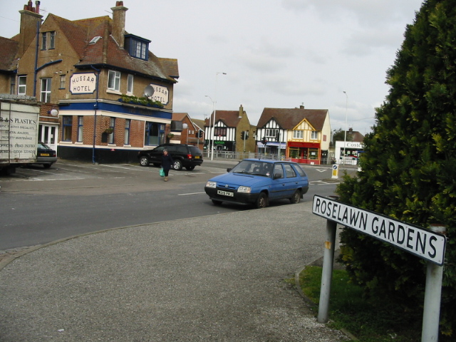
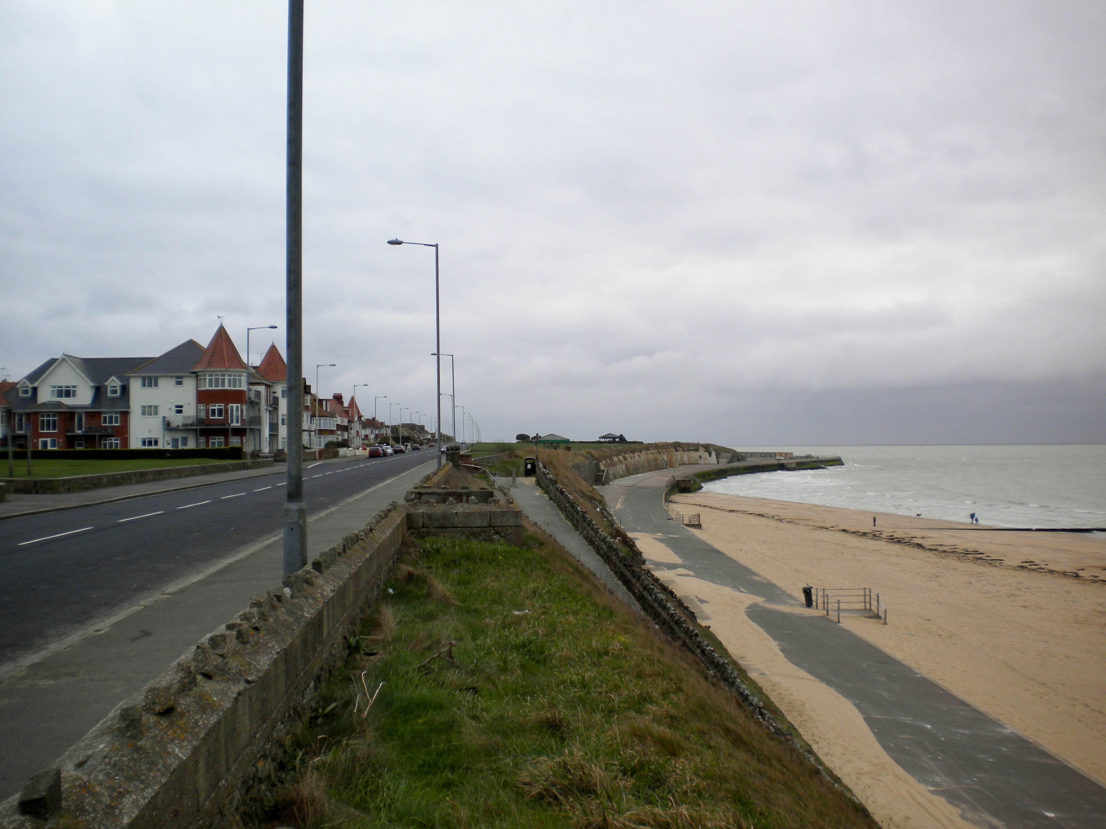
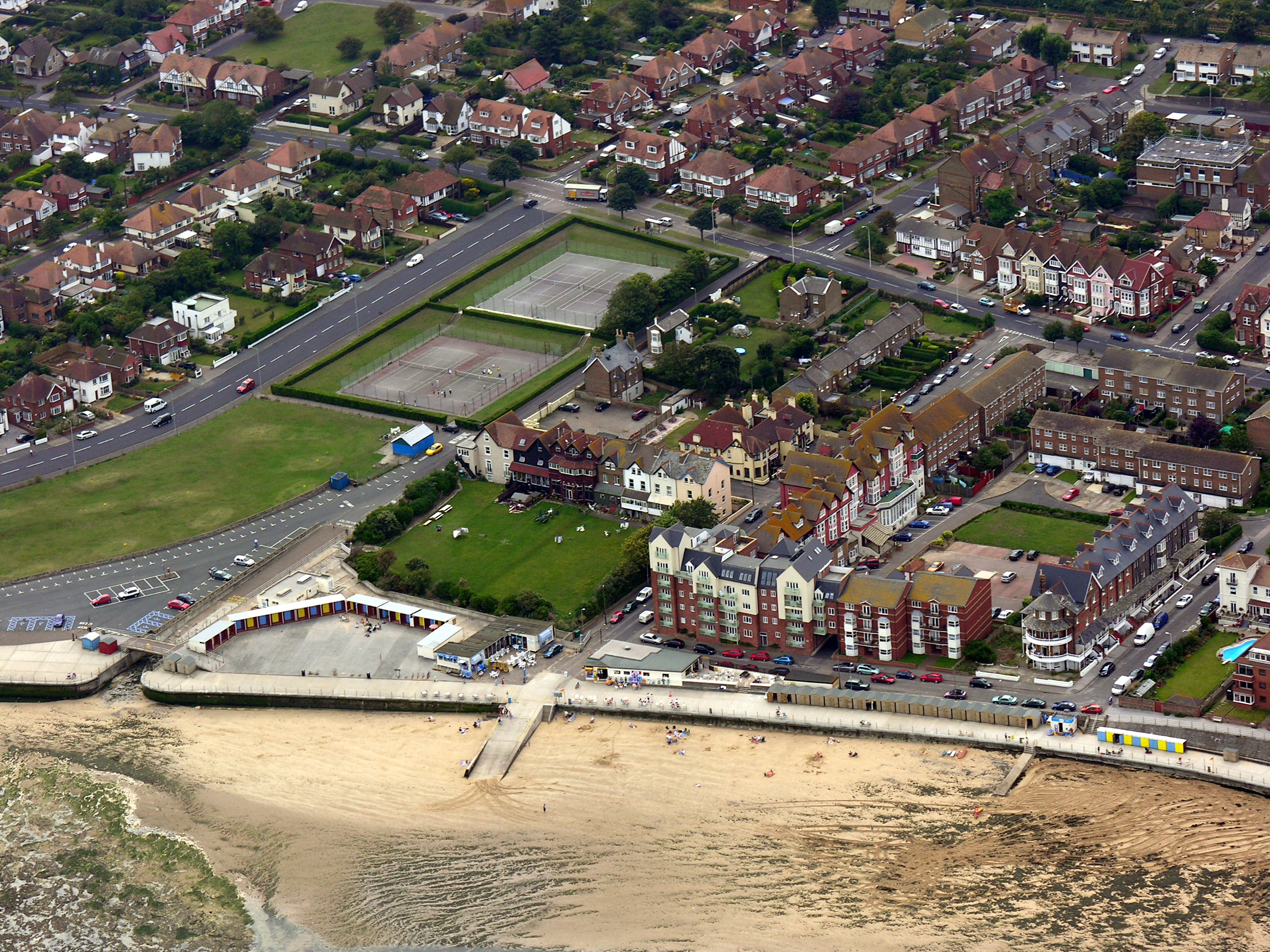
Garlinge is a small suburban village located in the district of Thanet, in the county of Kent, England. Situated just over two miles north of the coastal town of Margate, Garlinge is nestled between Westgate-on-Sea and Westbrook.

The village has a population of around 5,000 residents and is predominantly residential, characterized by a mix of detached houses, semi-detached properties, and a few apartment blocks. The area is known for its peaceful and family-friendly atmosphere, making it an attractive place to live for many local families and retirees.

Garlinge benefits from its proximity to the coast, with beautiful sandy beaches and scenic coastal walks just a short distance away. The village also boasts various amenities, including a primary school, a local convenience store, and a few pubs and eateries. For more extensive shopping and entertainment options, residents can easily access the nearby towns of Margate and Westgate-on-Sea.

Transport links in Garlinge are convenient, with regular bus services connecting the village to surrounding areas. The A28 road runs through the village, providing easy access to the wider Kent region and beyond.

Overall, Garlinge offers a charming and tranquil setting, ideal for those seeking a relaxed lifestyle within close proximity to the coast and nearby towns.

If you have any feedback on the listing, please let us know in the comments section below.

Garlinge Images

Images are sourced within 2km of 51.374477/1.35659 or Grid Reference TR3369. Thanks to Geograph Open Source API. All images are credited.

Arlington House Arlington House seen from the exit of Margate railway station. Built in 1964 as luxury apartments in the brutalist style.
Arlington House
Arlington House seen from the exit of Margate railway station. Built in 1964 as luxury apartments in the brutalist style.
Platform 1, Margate Station The station entrance is to the right of the photograph.
Platform 1, Margate Station
The station entrance is to the right of the photograph.
Nayland Rock Hotel The Nayland Rock Hotel seen from the Royal Crescent Promenade. Built as a crescent in the mid-19th Century, it is Grade II listed and currently due to be renovated and reopened as a spa and hotel. Arlington House is seen in the background.
Nayland Rock Hotel
The Nayland Rock Hotel seen from the Royal Crescent Promenade. Built as a crescent in the mid-19th Century, it is Grade II listed and currently due to be renovated and reopened as a spa and hotel. Arlington House is seen in the background.
Margate beach and the Ferris wheel
Space in front of Margate station
Promenade and beach in Margate
Margate : T.S. Eliot plaque, Margate Railway Station
Margate : Empire Cinema signage, Dreamland Temporary signage for Sam Mendes' feature film Lumière.
Margate : Empire Cinema signage, Dreamland
Temporary signage for Sam Mendes' feature film Lumière.
St Mildred’s Bay View from the promenade leading to St Mildred’s Gardens.
St Mildred’s Bay
View from the promenade leading to St Mildred’s Gardens.
St Mildred’s Bay View of the promenade leading to Ledge Point.
St Mildred’s Bay
View of the promenade leading to Ledge Point.
Westcliff House, 37, Sea Road This view of <a href="https://www.geograph.org.uk/photo/4972797">TR3270 : Westcliff House, 37, Sea Road</a> shows the building, when it was derelict. It has since been converted into a specialist care home.
Westcliff House, 37, Sea Road
This view of TR3270 : Westcliff House, 37, Sea Road shows the building, when it was derelict. It has since been converted into a specialist care home.
St Mildred’s Bay A view from the promenade overlooking a salt water paddling pool.
St Mildred’s Bay
A view from the promenade overlooking a salt water paddling pool.
Release the Seal Part of a painted nature mural, seen on the exterior wall of a private residential property.
One of a number of exterior wall on-street murals in the area, part of an arts trail exhibition.
The exterior wall brickwork is visible, as are the textures of the materials worn, the seals fur.
Release the Seal
Part of a painted nature mural, seen on the exterior wall of a private residential property. One of a number of exterior wall on-street murals in the area, part of an arts trail exhibition. The exterior wall brickwork is visible, as are the textures of the materials worn, the seals fur.
Marine Terrace, Margate, Kent
Ferris Wheel and Margate Beach
Westgate Bay
Westgate Bay
Carlton cinema
Carlton cinema
Westgate Church
Westgate Church
Show me another place!

Garlinge is located at Grid Ref: TR3369 (Lat: 51.374477, Lng: 1.35659)

Administrative County: Kent

District: Thanet

Police Authority: Kent

What 3 Words

///speeded.milder.cabbages. Near Westgate on Sea, Kent

Nearby Locations

Garlinge

Related Wikis

Garlinge

Garlinge is a village and suburb of Margate in Kent, England, situated 2 miles (3.2 km) southwest of the centre of the town. It is in the Thanet local...

Dandelion Paddock

Dandelion Paddock was a first-class cricket ground in Dent de Lion west of Margate, Kent. Sir Horatio Mann organised a number of matches there in the 1790s...

Hartsdown Academy

Hartsdown Academy is a secondary school with academy status in Margate in southeast England, which teaches years 7-14 (UK school years; age range 11–19...

Westbrook, Kent

Westbrook is a Victorian seaside resort on the Thanet peninsula in the southeast corner of England. It is the westernmost part of Margate and is part of...

Margate West

Margate West is an electoral division of Kent County Council covering Westgate-on-Sea, Westbrook and Garlinge. In the 2009 election, 3668 people voted...

Thanet West (UK Parliament constituency)

Thanet West was a British parliamentary constituency in the Isle of Thanet, in Kent. It was created for the February 1974 general election, when the former...

Royal Sea Bathing Hospital

The Royal Sea Bathing Hospital in Margate, Kent was founded in 1791 by Dr John Coakley Lettsom, a Quaker physician and philanthropist, for the treatment...

Hartsdown Park

Hartsdown Park is a football stadium located in Margate, Kent, England. It has been the home of Margate F.C. (known as Thanet United F.C. between 1981...

Nearby Amenities

Located within 500m of 51.374477,1.35659
Mini Roundabout
Direction: clockwise
Lat/Long: 51.3780402/1.3589709
Turning Circle
Lat/Long: 51.3773591/1.3543171
Turning Circle
Lat/Long: 51.3766784/1.3562224
Bus Stop
Birds Avenue
Bus: yes
Local Ref: adj
Naptan AtcoCode: 2400100354
Naptan Bearing: N
Naptan BusStopType: MKD
Naptan CommonName: Birds Avenue
Naptan Indicator: adj
Naptan Landmark: Birds Avenue
Naptan NaptanCode: kntgwjaj
Naptan PlusbusZoneRef: THANET
Naptan RevisionNumber: 1
Naptan Status: act
Naptan Street: Brooke Avenue
Naptan Verified: no
Public Transport: platform
Ref: kntgwjaj
Source: naptan_import
Source Date: 2018-02-20
Lat/Long: 51.3765036/1.358527
Bus Stop
Birds Avenue
Bus: yes
Local Ref: opp
Naptan AtcoCode: 2400100356
Naptan Bearing: S
Naptan BusStopType: MKD
Naptan CommonName: Birds Avenue
Naptan Indicator: opp
Naptan Landmark: Birds Avenue
Naptan NaptanCode: kntgwgwm
Naptan PlusbusZoneRef: THANET
Naptan RevisionNumber: 1
Naptan Status: act
Naptan Street: Brooke Avenue
Naptan Verified: no
Public Transport: platform
Ref: kntgwgwm
Source: naptan_import
Source Date: 2018-02-20
Lat/Long: 51.3760454/1.3586078
Bus Stop
Fulham Avenue
Bus: yes
Local Ref: o/s 31
Naptan AtcoCode: 2400100358
Naptan Bearing: E
Naptan BusStopType: MKD
Naptan CommonName: Fulham Avenue
Naptan Indicator: o/s 31
Naptan NaptanCode: kntgwjad
Naptan PlusbusZoneRef: THANET
Naptan RevisionNumber: 3
Naptan Status: act
Naptan Street: Fulham Avenue
Naptan Verified: no
Public Transport: platform
Ref: kntgwjad
Source: naptan_import
Source Date: 2018-02-20
Lat/Long: 51.3756311/1.3603813
Bus Stop
Caxton Road
Bus: yes
Local Ref: adj
Naptan AtcoCode: 2400A043610A
Naptan Bearing: SW
Naptan BusStopType: MKD
Naptan CommonName: Caxton Road
Naptan Indicator: adj
Naptan Landmark: Caxton Road
Naptan NaptanCode: kntdtptw
Naptan PlusbusZoneRef: THANET
Naptan RevisionNumber: 5
Naptan Status: act
Naptan Street: Westfield Road
Naptan Verified: no
Public Transport: platform
Ref: kntdtptw
Source: naptan_import
Source Date: 2018-02-20
Lat/Long: 51.3781656/1.3596957
Bus Stop
Craven Close
Bus: yes
Local Ref: adj
Naptan AtcoCode: 2400A043640A
Naptan Bearing: NE
Naptan BusStopType: MKD
Naptan CommonName: Craven Close
Naptan Indicator: adj
Naptan Landmark: Craven Close
Naptan NaptanCode: kntdtpwg
Naptan PlusbusZoneRef: THANET
Naptan RevisionNumber: 2
Naptan Status: act
Naptan Street: Fulham Avenue
Naptan Verified: no
Public Transport: platform
Ref: kntdtpwg
Source: naptan_import
Source Date: 2018-02-20
Lat/Long: 51.3762623/1.3628641
Bus Stop
Kingston Avenue
Bus: yes
Local Ref: o/s 60
Naptan AtcoCode: 2400A043650A
Naptan Bearing: SW
Naptan BusStopType: MKD
Naptan CommonName: Kingston Avenue
Naptan Indicator: o/s 60
Naptan NaptanCode: kntdtpwj
Naptan PlusbusZoneRef: THANET
Naptan RevisionNumber: 4
Naptan Status: act
Naptan Street: Kingston Avenue
Naptan Verified: no
Public Transport: platform
Ref: kntdtpwj
Source: naptan_import
Source Date: 2018-02-20
Lat/Long: 51.3749104/1.3615275
Bus Stop
Crow Hill Road
Bus: yes
Local Ref: adj
Naptan AtcoCode: 2400A043670A
Naptan Bearing: N
Naptan BusStopType: MKD
Naptan CommonName: Crow Hill Road
Naptan Indicator: adj
Naptan Landmark: Crow Hill Road
Naptan NaptanCode: kntdtpwp
Naptan PlusbusZoneRef: THANET
Naptan RevisionNumber: 6
Naptan Status: act
Naptan Street: Brooke Avenue
Naptan Verified: no
Public Transport: platform
Ref: kntdtpwp
Shelter: yes
Source: naptan_import
Source Date: 2018-02-20
Lat/Long: 51.3776774/1.3587475
Design: barrel
Power: tower
Lat/Long: 51.3734876/1.3631082
Post Box
Collection Plate: CP1D
Collection Times: Mo-Fr 09:00; Sa 07:00
Old Ref: CT9 86
Operator: Royal Mail
Operator Wikidata: Q638098
Post Box Type: wall
Ref: CT9 86D
Source: survey
Survey Date: 2023-09-11
Lat/Long: 51.375853/1.3563846
Garlinge
Place: suburb
Source: OS_OpenData_StreetView
Wikidata: Q5523481
Lat/Long: 51.3783141/1.3563826
Design: barrel
Power: tower
Lat/Long: 51.3718684/1.3558487
Design: barrel
Power: tower
Lat/Long: 51.3725704/1.3590157
Design: barrel
Power: tower
Lat/Long: 51.3711432/1.3526251
Mini Roundabout
Direction: clockwise
Lat/Long: 51.3779427/1.3588791
Generator Method: photovoltaic
Generator Output Electricity: yes
Generator Source: solar
Generator Type: solar_photovoltaic_panel
Location: roof
Power: generator
Lat/Long: 51.3778179/1.3571575
Generator Method: photovoltaic
Generator Output Electricity: yes
Generator Source: solar
Generator Type: solar_photovoltaic_panel
Location: roof
Power: generator
Lat/Long: 51.3749499/1.3582706
Generator Method: photovoltaic
Generator Output Electricity: yes
Generator Source: solar
Generator Type: solar_photovoltaic_panel
Location: roof
Power: generator
Lat/Long: 51.3749951/1.3582411
Post Box
Check Date: 2021-08-11
Collection Times: Mo-Fr 16:00; Sa 10:30
Drive Through: no
Operator: Royal Mail
Operator Wikidata: Q638098
Post Box Design: type_b
Post Box Type: pillar
Ref: CT9 79
Royal Cypher: GR
Royal Cypher Wikidata: Q33102273
Source: survey
Lat/Long: 51.3778978/1.3552967
Generator Method: photovoltaic
Generator Output Electricity: yes
Generator Source: solar
Generator Type: solar_photovoltaic_panel
Location: roof
Power: generator
Lat/Long: 51.3787805/1.3570073
Generator Method: photovoltaic
Generator Output Electricity: yes
Generator Source: solar
Generator Type: solar_photovoltaic_panel
Location: roof
Power: generator
Lat/Long: 51.3749968/1.353896
Generator Method: photovoltaic
Generator Output Electricity: yes
Generator Source: solar
Generator Type: solar_photovoltaic_panel
Location: roof
Power: generator
Lat/Long: 51.3751843/1.3546255
Generator Method: photovoltaic
Generator Output Electricity: yes
Generator Source: solar
Generator Type: solar_photovoltaic_panel
Location: roof
Power: generator
Lat/Long: 51.3752387/1.3606417
Generator Method: photovoltaic
Generator Output Electricity: yes
Generator Source: solar
Generator Type: solar_photovoltaic_panel
Location: roof
Power: generator
Lat/Long: 51.3752379/1.3606752
Generator Method: photovoltaic
Generator Output Electricity: yes
Generator Source: solar
Generator Type: solar_photovoltaic_panel
Location: roof
Power: generator
Lat/Long: 51.3772554/1.3619587
Generator Method: photovoltaic
Generator Output Electricity: yes
Generator Source: solar
Generator Type: solar_photovoltaic_panel
Location: roof
Power: generator
Lat/Long: 51.3782733/1.3591933
Board Type: notice
Information: board
Operator: Garlinge Residents Association
Tourism: information
Lat/Long: 51.3781082/1.3551248
Hengrove Farm
Place: farm
Source: OS_OpenData_StreetView
Lat/Long: 51.3711994/1.3596976
The data included in this document is from www.openstreetmap.org. The data is made available under ODbL.

Have you been to Garlinge?

Leave your review of Garlinge below (or comments, questions and feedback).