Bennane Head

Coastal Feature, Headland, Point in Ayrshire

Scotland

Bennane Head

Raised beach and old cliffline at Corseclays, north of Ballantrae
Raised beach and old cliffline at Corseclays, north of Ballantrae Credit: Oliver Dixon

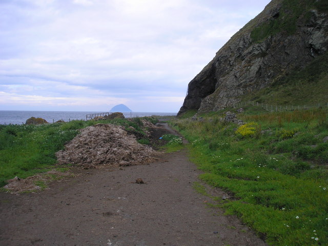
Bennane Head is a prominent coastal feature located in Ayrshire, Scotland. It is a headland that extends into the Firth of Clyde, forming a distinctive point along the coastline.

The headland is characterized by its rugged cliffs that rise dramatically from the sea, offering breathtaking views of the surrounding landscape. The cliffs are composed of various rock formations, including sandstone and granite, which have been shaped by natural erosion processes over millions of years. These geological features attract geologists and nature enthusiasts who are interested in studying the area's unique formations.

Bennane Head is also known for its diverse wildlife. The surrounding waters are home to a variety of marine species, including seals, dolphins, and seabirds. Birdwatchers often visit the headland to observe the numerous species of birds that inhabit the area, including gannets, razorbills, and kittiwakes.

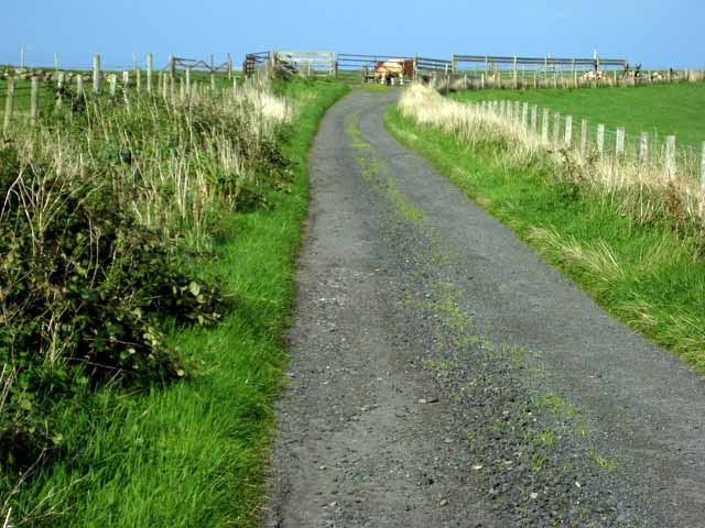
The headland is accessible to the public, with a designated footpath that allows visitors to explore the area safely. There are also a few viewing platforms strategically placed along the path, providing visitors with panoramic views of the coastline and the open sea.

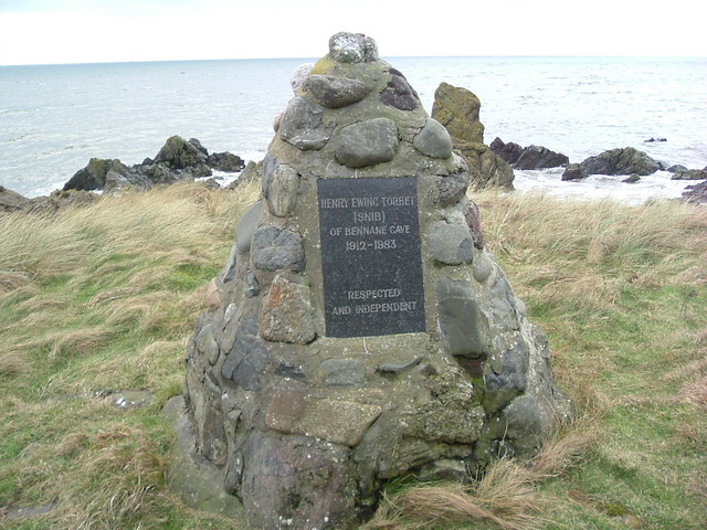
Bennane Head holds historical significance as well. The area is believed to have been inhabited by humans as far back as the Neolithic period, and there are several archaeological sites in the vicinity, including ancient burial grounds and standing stones.

Overall, Bennane Head is a stunning coastal feature that offers visitors a chance to immerse themselves in the natural beauty and rich history of Ayrshire's coastline.

If you have any feedback on the listing, please let us know in the comments section below.

Bennane Head Images

Images are sourced within 2km of 55.137983/-4.9942285 or Grid Reference NX0986. Thanks to Geograph Open Source API. All images are credited.

Raised beach and old cliffline at Corseclays, north of Ballantrae
Driveway to Hilltop Cottage, Corseclays
Sawny Bean's Cave Port Balcreuchan and the cave of Sawny Bean, Ayrshire's infamous serial cannibal. Mr. Bean and his family are credited with killing and eating over 1000 hapless victims in the 16th century - kind of makes Hannibal Lecter look like a pussy cat!
Sawny Bean's Cave
Port Balcreuchan and the cave of Sawny Bean, Ayrshire's infamous serial cannibal. Mr. Bean and his family are credited with killing and eating over 1000 hapless victims in the 16th century - kind of makes Hannibal Lecter look like a pussy cat!
Sunset over Balcreuchan Port Parking lay bay on A77 above Sawny Bean's Cave, looking west towards the Irish Coast.
Sunset over Balcreuchan Port
Parking lay bay on A77 above Sawny Bean's Cave, looking west towards the Irish Coast.
Corseclays Farm, near Ballantrae On the B734. The hill in the distance is Knockdollan <a href="https://www.geograph.org.uk/gridref/NX1184">NX1184</a>.
Corseclays Farm, near Ballantrae
On the B734. The hill in the distance is Knockdollan NX1184.
Defunct main Ballantrae-Girvan road (formerly A77) showing present use as winter cattle feed station Part of the old coaching road dating from the early 1900s, bypassed by a three-lane road on the other side of the hill. Area used to feed cattle in winter.
Defunct main Ballantrae-Girvan road (formerly A77) showing present use as winter cattle feed station
Part of the old coaching road dating from the early 1900s, bypassed by a three-lane road on the other side of the hill. Area used to feed cattle in winter.
Bennane Cave This cave was the home, for many years, of Henry Ewing Torbet AKA Snib Scott a gentleman of the road
Bennane Cave
This cave was the home, for many years, of Henry Ewing Torbet AKA Snib Scott a gentleman of the road
Monument to Snib Scott Erected by public subscription, constructed of stones from the shore by Mr Sparkhall of Ballantrae.
Monument to Snib Scott
Erected by public subscription, constructed of stones from the shore by Mr Sparkhall of Ballantrae.
From Bennane Head Looking towards Ailsa Craig from the car park on the north side of Bennane Head.  Northern Ireland is visible behind the Craig, with the Kintyre Peninsula to the right.
From Bennane Head
Looking towards Ailsa Craig from the car park on the north side of Bennane Head. Northern Ireland is visible behind the Craig, with the Kintyre Peninsula to the right.
Down To Balcreuchan Port Looking down from the cliff edge at the view point car park.  The novel "The Grey Man", by S.R. Crockett, contains a stomach-churning account of Sawney Bean's cave, which lies underneath the land here.
Down To Balcreuchan Port
Looking down from the cliff edge at the view point car park. The novel "The Grey Man", by S.R. Crockett, contains a stomach-churning account of Sawney Bean's cave, which lies underneath the land here.
Abandoned milk-shake bar The view of a car parking area and an abandoned kiosk from which milk shakes were once sold.
Abandoned milk-shake bar
The view of a car parking area and an abandoned kiosk from which milk shakes were once sold.
The former A77 Ballantrae to Lendalfoot section The view back towards Ballantrae and the new section of the A77 which crosses over the eastern shoulder of Bennane Hill.  This section of road is still a public road, whereas to the north it is used only as a farm track.
The former A77 Ballantrae to Lendalfoot section
The view back towards Ballantrae and the new section of the A77 which crosses over the eastern shoulder of Bennane Hill. This section of road is still a public road, whereas to the north it is used only as a farm track.
The track/road to Bennane Cave The former A77 road leading to the entrance to Bennane Cave <a href="https://www.geograph.org.uk/photo/347446">NX0986 : Bennane Cave</a> which can be seen on the right.  The road is now used as a farm track and continues round the headland <a href="https://www.geograph.org.uk/photo/347434">NX0986 : Defunct main Ballantrae-Girvan road (formerly A77) showing present use as winter cattle feed station</a>.  Ailsa Craig can be seen in the distance <a href="https://www.geograph.org.uk/photo/605729">NX0299 : Ailsa Craig (from the Scottish mainland near Girvan)</a>.
The track/road to Bennane Cave
The former A77 road leading to the entrance to Bennane Cave NX0986 : Bennane Cave which can be seen on the right. The road is now used as a farm track and continues round the headland NX0986 : Defunct main Ballantrae-Girvan road (formerly A77) showing present use as winter cattle feed station. Ailsa Craig can be seen in the distance NX0299 : Ailsa Craig (from the Scottish mainland near Girvan).
Uneven coastal terrace along the A77 road
Towards Bennane Lea Looking along the beach to the north of Ballantrae towards the cottage at Bennane Lea.  Viewed on a fine but chilly New Year's Day, with the snow-covered mountains of Arran providing a spectacular backdrop.
Towards Bennane Lea
Looking along the beach to the north of Ballantrae towards the cottage at Bennane Lea. Viewed on a fine but chilly New Year's Day, with the snow-covered mountains of Arran providing a spectacular backdrop.
The Mouth of the Red Burn Looking along the Clyde coast to the north of Ballantrae, where the Red Burn enters the sea.  Viewed on New Year's Day.  The beach was still frozen hard that morning, after a long spell of unusually cold weather.
The Mouth of the Red Burn
Looking along the Clyde coast to the north of Ballantrae, where the Red Burn enters the sea. Viewed on New Year's Day. The beach was still frozen hard that morning, after a long spell of unusually cold weather.
The Cairn at Bennane Lea This cairn was erected in memory of Henry Ewing Torbett, known as "Snib".  He was a former bank clerk from Dundee who later lived the life of a hermit in a cave at Bennane Lea.  He died in 1983, when he was seventy-one years old.  For more information, see the Ayrshire Coastal Path website.   <span class="nowrap"><a title="http://www.ayrshirecoastalpath.org/index.html" rel="nofollow ugc noopener" href="http://www.ayrshirecoastalpath.org/index.html">Link</a><img style="margin-left:2px;" alt="External link" title="External link - shift click to open in new window" src="https://s1.geograph.org.uk/img/external.png" width="10" height="10"/></span>
The Cairn at Bennane Lea
This cairn was erected in memory of Henry Ewing Torbett, known as "Snib". He was a former bank clerk from Dundee who later lived the life of a hermit in a cave at Bennane Lea. He died in 1983, when he was seventy-one years old. For more information, see the Ayrshire Coastal Path website. LinkExternal link
Snib Torbett's Cave at Bennane Lea This cave was inhabited up to 1983 by Snib Torbet - see <a href="https://www.geograph.org.uk/photo/1715914">NX0986 : The Cairn at Bennane Lea</a>.  The walled frontage was built to house a smiddy when the road was being constructed round Bennane Head.  A high cave lies inside, with another one going deep into the hillside. (Source:  Ayrshire Coastal Path", by James A Begg). As I had no torch with me when I visited, I stayed in the outer cave.
Snib Torbett's Cave at Bennane Lea
This cave was inhabited up to 1983 by Snib Torbet - see NX0986 : The Cairn at Bennane Lea. The walled frontage was built to house a smiddy when the road was being constructed round Bennane Head. A high cave lies inside, with another one going deep into the hillside. (Source: Ayrshire Coastal Path", by James A Begg). As I had no torch with me when I visited, I stayed in the outer cave.
Show me another place!

Bennane Head is located at Grid Ref: NX0986 (Lat: 55.137983, Lng: -4.9942285)

Unitary Authority: South Ayrshire

Police Authority: Ayrshire

What 3 Words

///assets.includes.houseboat. Near Girvan, South Ayrshire

Related Wikis

Bennane Head

Bennane Head is a tapering piece of land formed of hard rock projecting into the Firth of Clyde, Scotland, at the northern end of Ballantrae Bay, 17 kilometres...

Ballantrae Windmill

The Ballantrae Windmill, on Mill Hill was a late 17th or early 18th century vaulted tower windmill, the ruins of which are located above the old raised...

River Stinchar

The River Stinchar ( STIN-shər) is a river in South Ayrshire, Scotland. It flows south west from the Galloway Forest Park to enter the Firth of Clyde at...

Ballantrae

Ballantrae is a community in Carrick, South Ayrshire, Scotland. The name probably comes from the Scottish Gaelic Baile na Tràgha, meaning the "town by...

Heronsford

Heronsford is a village located in South Ayrshire, South-West Scotland. == About == Heronsford is a hamlet located near Ballantrae that sits along the...

Dumbarton Collegiate Church

The Collegiate Church of St Mary, Dumbarton, Scotland, was founded in about 1453 by Isabella, Countess of Lennox and Duchess of Albany. During the medieval...

Lendalfoot

Lendalfoot is a small village located on Carleton Bay, parish of Colmonell in the old district of Carrick, now South Ayrshire, about six miles (ten kilometres...

Colmonell

Colmonell (Scottish Gaelic: Cill Cholmain Eala) (meaning the church of St. Colman of Lainn Eala - in Lynally, County Offaly, Ireland) is a small village...

Nearby Amenities

Located within 500m of 55.137983,-4.9942285
Created By: almien_coastlines
Lat/Long: 55.142043/-4.991962
Created By: almien_coastlines
Lat/Long: 55.141787/-4.991949
Created By: almien_coastlines
Lat/Long: 55.141267/-4.992371
Created By: almien_coastlines
Lat/Long: 55.141004/-4.992805
Created By: almien_coastlines
Lat/Long: 55.140485/-4.993226
Created By: almien_coastlines
Lat/Long: 55.139966/-4.993647
Created By: almien_coastlines
Lat/Long: 55.139307/-4.994732
Created By: almien_coastlines
Lat/Long: 55.138909/-4.995606
Created By: almien_coastlines
Lat/Long: 55.138127/-4.996461
Created By: almien_coastlines
Lat/Long: 55.137355/-4.996647
Created By: almien_coastlines
Lat/Long: 55.137099/-4.996635
Created By: almien_coastlines
Lat/Long: 55.135571/-4.996111
Created By: almien_coastlines
Lat/Long: 55.134796/-4.996519
Created By: almien_coastlines
Source: PGS
Lat/Long: 55.134291/-4.996047
Created By: almien_coastlines
Source: PGS
Lat/Long: 55.134035/-4.996035
Created By: almien_coastlines
Source: PGS
Lat/Long: 55.133779/-4.996022
Bennane Head
Natural: cape
Wikidata: Q4889605
Wikipedia: en:Bennane Head
Lat/Long: 55.1378421/-4.9963454
Barrier: entrance
Lat/Long: 55.1370895/-4.9875999
Barrier: entrance
Lat/Long: 55.1372046/-4.9880634
Power: pole
Lat/Long: 55.1370015/-4.9866468
Power: pole
Lat/Long: 55.1366964/-4.9872206
Power: pole
Lat/Long: 55.1360457/-4.9877921
Power: pole
Lat/Long: 55.1353843/-4.9884176
Power: pole
Lat/Long: 55.1347256/-4.9890103
The data included in this document is from www.openstreetmap.org. The data is made available under ODbL.

Have you been to Bennane Head?

Leave your review of Bennane Head below (or comments, questions and feedback).