An Fhaighear Bheag

Coastal Feature, Headland, Point in Ross-shire

Scotland

An Fhaighear Bheag

Firemore Beach on the side of Loch Ewe Rich red sand.
Firemore Beach on the side of Loch Ewe Credit: Julian Paren

An Fhaighear Bheag, also known as Little Fheighear, is a coastal feature located in Ross-shire, Scotland. Situated on the northwestern coast of the country, it is specifically located on a headland that protrudes into the sea. This headland is commonly referred to as a point due to its narrow and elongated shape.

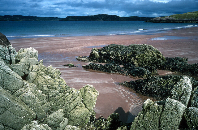
An Fhaighear Bheag offers stunning views of the surrounding landscape, including the vast expanse of the North Atlantic Ocean. The headland is characterized by steep cliffs that drop dramatically into the sea, creating a picturesque and rugged coastline. These cliffs are composed of various rock formations, including sandstone and shale, which have been shaped by the relentless forces of erosion over time.

The area surrounding An Fhaighear Bheag is rich in biodiversity and supports a diverse range of plant and animal species. The headland is covered in lush vegetation, with hardy grasses and wildflowers clinging to the rocky terrain. It is also home to several species of seabirds, including gulls, fulmars, and puffins, which nest along the cliffs during the breeding season.

The rugged beauty of An Fhaighear Bheag attracts outdoor enthusiasts and nature lovers alike. Visitors can explore the headland by following walking trails that meander along the coastline, offering breathtaking views at every turn. The area is also popular for birdwatching and photography, as the headland provides ample opportunities to capture stunning images of the surrounding landscape and wildlife.

Overall, An Fhaighear Bheag is a captivating coastal feature that showcases the natural beauty of the Ross-shire region. Its dramatic cliffs, diverse ecosystems, and panoramic views make it a must-visit destination for those seeking to immerse themselves in Scotland's stunning coastal scenery.

If you have any feedback on the listing, please let us know in the comments section below.

An Fhaighear Bheag Images

Images are sourced within 2km of 57.8255/-5.6641062 or Grid Reference NG8287. Thanks to Geograph Open Source API. All images are credited.

Firemore Beach on the side of Loch Ewe Rich red sand.
Firemore Beach on the side of Loch Ewe
Rich red sand.
B8057 near Poolewe, Scottish Highlands
Loch Sguod from the path to Camas Mor Loch Ewe (sea loch) lies beyond.
Loch Sguod from the path to Camas Mor
Loch Ewe (sea loch) lies beyond.
Camas na Muic and the beach at Firemore
Uidh Chrò - the outflow from Loch Sguod
Lifebelt at Camas na Muic, Firemore
Buildings at Coast, Inverasdale In the distance, beyond Loch Ewe, the mountains of the Fisherfield Forest.
Buildings at Coast, Inverasdale
In the distance, beyond Loch Ewe, the mountains of the Fisherfield Forest.
Looking up Loch Ewe towards Inverewe Gardens
Monkey puzzle tree (Araucaria araucana) by Loch ewe at Inverasdale
Firemore Beach
Firemore Beach
Cnoc nam Buth
Cnoc nam Buth
Firemore beach
Firemore beach
Light anti-aircraft battery, Mellangaun, Ross and Cromarty This gun emplacement was part of the Second World War defences of Loch Ewe from where Russian Arctic Convoys sailed.  Nearby are the remains of a brick structure, possibly a magazine, and three concrete hut bases.
Light anti-aircraft battery, Mellangaun, Ross and Cromarty
This gun emplacement was part of the Second World War defences of Loch Ewe from where Russian Arctic Convoys sailed. Nearby are the remains of a brick structure, possibly a magazine, and three concrete hut bases.
Loch Ewe coastline at Inverasdale
Road (B8057) at Inverasdale Looking northward.
Road (B8057) at Inverasdale
Looking northward.
Road (B8057) at Iverasdale
Road (B8057) and Bridge crossing Uidh Chro near Firemore Looking south-eastward.
Road (B8057) and Bridge crossing Uidh Chro near Firemore
Looking south-eastward.
Footpath to Firemore Beach and Loch Ewe Looking eastward
Footpath to Firemore Beach and Loch Ewe
Looking eastward
Show me another place!

An Fhaighear Bheag is located at Grid Ref: NG8287 (Lat: 57.8255, Lng: -5.6641062)

Unitary Authority: Highland

Police Authority: Highlands and Islands

What 3 Words

///tonight.react.cashiers. Near Gairloch, Highland

Nearby Locations

An Fhaighear Bheag

Related Wikis

Inverasdale

Inverasdale (Scottish Gaelic: Inbhir Àsdail) is a hamlet in the Northwest Highlands of Scotland, located by Loch Ewe, in the region of Wester Ross. �...

Isle of Ewe

The Isle of Ewe (Scottish Gaelic: Eilean Iùbh) is a small Scottish island on the west coast of Ross and Cromarty. The island is inhabited by a single family...

Loch Ewe

Loch Ewe (Scottish Gaelic: Loch Iùbh) is a sea loch in the region of Wester Ross in the Northwest Highlands of Scotland. The shores are inhabited by a...

Cove, Highland

Cove is a remote hamlet located on the northwestern shore of the sea loch Loch Ewe, and 8 mi (13 km) northwest of Poolewe in Ross-shire, Scottish Highlands...

Nearby Amenities

Located within 500m of 57.8255,-5.6641062
Source: PGS
Lat/Long: 57.8269563/-5.6681706
Source: PGS
Lat/Long: 57.8268454/-5.6686357
Source: PGS
Lat/Long: 57.8272704/-5.669481
Source: PGS
Lat/Long: 57.8279262/-5.6699512
Source: PGS
Lat/Long: 57.8284891/-5.6699908
Created By: almien_coastlines
Source: PGS
Lat/Long: 57.828737/-5.669864
Created By: almien_coastlines
Source: PGS
Lat/Long: 57.82887/-5.669633
Source: PGS
Lat/Long: 57.82902/-5.6677442
Created By: almien_coastlines
Source: PGS
Lat/Long: 57.82891/-5.667716
Source: PGS
Lat/Long: 57.8289089/-5.6673667
Source: PGS
Lat/Long: 57.8291689/-5.6670893
Created By: almien_coastlines
Source: PGS
Lat/Long: 57.829309/-5.667026
Source: PGS
Lat/Long: 57.8294909/-5.6667931
Source: PGS
Lat/Long: 57.8217676/-5.6614914
Source: PGS
Lat/Long: 57.8219003/-5.6613745
Source: PGS
Lat/Long: 57.8228134/-5.6610989
Source: PGS
Lat/Long: 57.8230583/-5.6621015
Source: PGS
Lat/Long: 57.8231803/-5.6628726
Source: PGS
Lat/Long: 57.8234188/-5.6634269
Source: PGS
Lat/Long: 57.8237166/-5.6638596
Source: PGS
Lat/Long: 57.8245296/-5.6636914
Created By: almien_coastlines
Source: PGS
Lat/Long: 57.825298/-5.662889
Source: PGS
Lat/Long: 57.8262168/-5.6634098
Created By: almien_coastlines
Source: PGS
Lat/Long: 57.826311/-5.663444
Source: PGS
Lat/Long: 57.826532/-5.6636223
Source: PGS
Lat/Long: 57.8259454/-5.66499
Source: PGS
Lat/Long: 57.8259925/-5.6658239
Source: PGS
Lat/Long: 57.8262553/-5.666866
Source: PGS
Lat/Long: 57.8265128/-5.6668071
Created By: almien_coastlines
Source: PGS
Lat/Long: 57.826619/-5.667066
Power: pole
Lat/Long: 57.8264446/-5.6723623
Power: pole
Lat/Long: 57.8258007/-5.6720116
Power: pole
Lat/Long: 57.825214/-5.6717656
Power: pole
Lat/Long: 57.8251987/-5.670627
Power: pole
Lat/Long: 57.8251861/-5.669533
Power: pole
Lat/Long: 57.8251805/-5.6680804
Power: pole
Lat/Long: 57.8251708/-5.6666068
Power: pole
Lat/Long: 57.8251624/-5.6651673
The data included in this document is from www.openstreetmap.org. The data is made available under ODbL.

Have you been to An Fhaighear Bheag?

Leave your review of An Fhaighear Bheag below (or comments, questions and feedback).