Cligga Head

Coastal Feature, Headland, Point in Cornwall

England

Cligga Head

Chapel Rock
Chapel Rock Credit: Paul Barnett

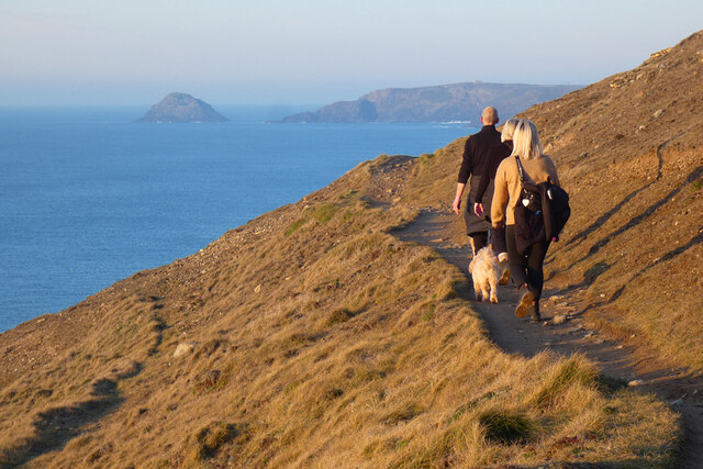
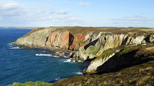
Cligga Head is a prominent headland located on the north coast of Cornwall, England. Situated near the town of Perranporth, it is a popular coastal feature known for its rugged beauty and geological significance. The headland is composed of slate and granite, and its cliffs reach heights of up to 200 feet, offering breathtaking views of the surrounding coastline.

Cligga Head is renowned for its rich mining history. In the 19th century, the area was a hub for copper and tin mining, with several mines operating along its cliffs. Today, remnants of this industrial past can still be seen, including old mine shafts and ruins. The headland also boasts a unique geological feature known as Cligga Clays, which are exposed layers of colorful clay deposits resulting from the mining activities.

The headland is a haven for wildlife enthusiasts and birdwatchers, as it provides a habitat for various bird species, including peregrine falcons and kestrels. The surrounding sea is home to seals, and dolphins can often be spotted swimming offshore.

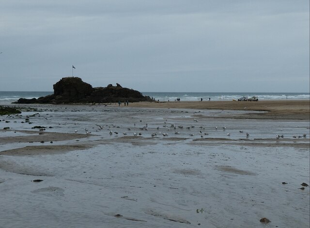
Cligga Head offers outdoor enthusiasts a range of activities to enjoy. The cliffs are a popular spot for rock climbing, providing challenging routes for climbers of all levels. The headland is also a great starting point for coastal hikes, with several walking trails that lead to nearby landmarks such as Perranporth Beach and Trevellas Porth.

In summary, Cligga Head is a striking coastal feature in Cornwall, known for its towering cliffs, mining history, and natural beauty. It offers visitors a chance to explore its rugged landscapes, learn about its industrial past, and observe the diverse wildlife that calls the area home.

If you have any feedback on the listing, please let us know in the comments section below.

Cligga Head Images

Images are sourced within 2km of 50.339852/-5.1799763 or Grid Reference SW7353. Thanks to Geograph Open Source API. All images are credited.

Chapel Rock
Chapel Rock
Coastal path, Perranzabuloe Gull Rocks and Penhale Point are seen from the path passing above Shag Rock.
Coastal path, Perranzabuloe
Gull Rocks and Penhale Point are seen from the path passing above Shag Rock.
Farmland and houses, Perranzabuloe Cramped modern houses on the southern edge of Perranporth reflect a style of architecture currently popular in the area. They are seen across a valley from Coombe View.
Farmland and houses, Perranzabuloe
Cramped modern houses on the southern edge of Perranporth reflect a style of architecture currently popular in the area. They are seen across a valley from Coombe View.
B3284 towards Perranporth
Perranporth - Chapel Rock Looking across the seagull-bedecked sands of Perranporth beach to Chapel Rock which is sporting a Cornish flag.
Perranporth - Chapel Rock
Looking across the seagull-bedecked sands of Perranporth beach to Chapel Rock which is sporting a Cornish flag.
Clock tower and wind vane, Perranporth
St George's Hill, Perranporth Two bungalows on the hill south of the village, surrounded by farmland
St George's Hill, Perranporth
Two bungalows on the hill south of the village, surrounded by farmland
Communications from Trevellas Postbox and telephone box by the B3285 at the north of the village
Communications from Trevellas
Postbox and telephone box by the B3285 at the north of the village
Perranporth Beach The sandy beach of Perranporth in Cornwall, England.
Perranporth Beach
The sandy beach of Perranporth in Cornwall, England.
The Clock Tower in Perranporth The Clock Tower in central Perranporth, Cornwall, England.
The Clock Tower in Perranporth
The Clock Tower in central Perranporth, Cornwall, England.
Perranporth Beach and Car Park This one of the main car parks of the town on the left with the beach on the right.
Perranporth Beach and Car Park
This one of the main car parks of the town on the left with the beach on the right.
Perranporth Beach and Chapel rock This is low tide on the beach with the waters of the river meandering across the sands towards Chapel Rock which sits in the middle of the bay.
Perranporth Beach and Chapel rock
This is low tide on the beach with the waters of the river meandering across the sands towards Chapel Rock which sits in the middle of the bay.
River Bridge at Perranporth This small footbridge across the stream that runs through the centre of the village and on to the beach has a cast iron hinged tide gate that allows high river flows downstream but restricts tidal backflows upstream.
River Bridge at Perranporth
This small footbridge across the stream that runs through the centre of the village and on to the beach has a cast iron hinged tide gate that allows high river flows downstream but restricts tidal backflows upstream.
Perranporth beach and Chapel Rock
Pillarbox in Perranporth A double ERII pillarbox in Perranporth.
Pillarbox in Perranporth
A double ERII pillarbox in Perranporth.
Cliff scenery S of Cligga Head near Perranporth
The Church of St Michael at Perranporth Viewed from the south-east.
The Church of St Michael at Perranporth
Viewed from the south-east.
St Georges Hill (B3285) in Perranporth Looking north-eastward.
St Georges Hill (B3285) in Perranporth
Looking north-eastward.
Show me another place!

Cligga Head is located at Grid Ref: SW7353 (Lat: 50.339852, Lng: -5.1799763)

Unitary Authority: Cornwall

Police Authority: Devon and Cornwall

What 3 Words

///polka.racetrack.audible. Near Perranporth, Cornwall

Nearby Locations

Hanover Cove Cligga Head

Related Wikis

Hanover (ship)

Hanover was a two-masted brigantine packet ship owned and operated by the Falmouth Post Office Packet Service, which operated between 1688 and 1852. On...

RAF Perranporth

Royal Air Force Perranporth or more simply RAF Perranporth is a former Royal Air Force satellite station situated near Perranporth, Cornwall, in the United...

Perranporth Airfield

Perranporth Airfield (ICAO: EGTP) airfield is located 1.5 NM (2.8 km; 1.7 mi) southwest of Perranporth and 6 NM (11 km; 6.9 mi) southwest of Newquay, in...

Cornish Parachute Centre

The Cornish Parachute Centre is a BPA affiliated parachuting centre and skydiving drop zone at St Agnes, Cornwall. The centre opened in 2006 operating...

Nearby Amenities

Located within 500m of 50.339852,-5.1799763
Source: PGS
Lat/Long: 50.3408108/-5.1740407
Source: PGS
Lat/Long: 50.3408393/-5.1755562
Source: PGS
Lat/Long: 50.3408365/-5.1782309
Source: PGS
Lat/Long: 50.3405705/-5.1787437
Source: PGS
Lat/Long: 50.3406585/-5.1800543
Source: PGS
Lat/Long: 50.3404154/-5.1812849
Source: PGS
Lat/Long: 50.3402565/-5.1814619
Source: PGS
Lat/Long: 50.3399498/-5.1810488
Source: PGS
Lat/Long: 50.3399289/-5.1812516
Source: PGS
Lat/Long: 50.3397286/-5.1817923
Source: PGS
Lat/Long: 50.3394581/-5.1816292
Source: PGS
Lat/Long: 50.3391894/-5.1815729
Source: PGS
Lat/Long: 50.3389175/-5.1814286
Source: PGS
Lat/Long: 50.3387758/-5.1812532
Source: PGS
Lat/Long: 50.3386713/-5.1809962
Source: PGS
Lat/Long: 50.3382386/-5.1805446
Source: PGS
Lat/Long: 50.3378869/-5.1805135
Source: PGS
Lat/Long: 50.336765/-5.180235
Source: PGS
Lat/Long: 50.3365605/-5.1802769
Source: PGS
Lat/Long: 50.3363684/-5.1801133
Source: PGS
Lat/Long: 50.3361681/-5.1800843
Source: PGS
Lat/Long: 50.3359921/-5.1801589
Source: PGS
Lat/Long: 50.3357244/-5.1800875
Source: PGS
Lat/Long: 50.3355631/-5.1808514
Source: PGS
Lat/Long: 50.3353867/-5.1808482
Description: tin mine
Historic: mine
Lat/Long: 50.3392983/-5.1761466
Cligga Head
Place: locality
Source: OD Streetview
Lat/Long: 50.3399488/-5.18289
Bench
Lat/Long: 50.336301/-5.1785231
The data included in this document is from www.openstreetmap.org. The data is made available under ODbL.

Have you been to Cligga Head?

Leave your review of Cligga Head below (or comments, questions and feedback).