Rubha na Faoilinn

Coastal Feature, Headland, Point in Argyllshire

Scotland

Rubha na Faoilinn

Rubha na Faoilinn Rubha na Faoilinn is the headland at the southeast side of the entrance to Loch Buie, and is exposed to swell even on a very calm day such as the one seen here. The ridge behind the wave-cut platform rises to 301m at Cnoc a'Ghille, though the skyline seen in the picture is nearer and lower.
Rubha na Faoilinn Credit: Andy Waddington

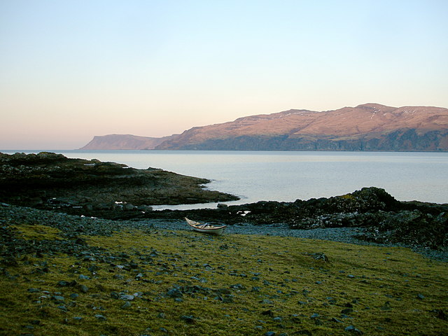
Rubha na Faoilinn is a prominent headland located in Argyllshire, Scotland. Situated on the west coast of the country, it juts out into the Atlantic Ocean, offering breathtaking views of the surrounding landscape. The name Rubha na Faoilinn translates to "Point of the Seagulls", which is fitting considering the abundance of these graceful birds that can be seen soaring above the headland.

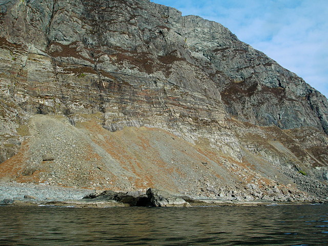
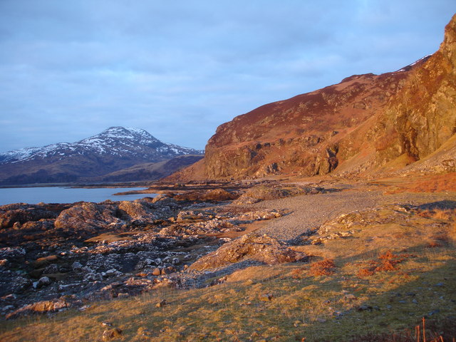
This coastal feature is characterized by its rugged cliffs and rocky terrain. The headland rises to an impressive height, providing visitors with panoramic vistas of the vast ocean and the nearby islands. The cliffs are adorned with vibrant green vegetation, adding a splash of color to the otherwise stark landscape. The sound of crashing waves against the rocks can be heard, creating a mesmerizing and soothing atmosphere.

Access to Rubha na Faoilinn is available through a well-maintained footpath that winds its way along the coastline. This path offers a leisurely and picturesque walk, allowing visitors to appreciate the natural beauty of the area. Along the route, there are occasional benches and lookout points where one can pause and take in the stunning scenery.

The headland is a popular spot for outdoor enthusiasts, including hikers, birdwatchers, and photographers. It is known for its diverse birdlife, including gannets, fulmars, and, of course, the seagulls after which it is named. Wildlife enthusiasts may also be lucky enough to spot seals lounging on the rocks or dolphins and porpoises swimming offshore.

Overall, Rubha na Faoilinn is a captivating coastal feature that offers a glimpse into the raw beauty of Scotland's western coast. Whether exploring its cliffs, enjoying its panoramic views, or observing the abundant wildlife, visitors are sure to be captivated by the natural wonders found at this headland.

If you have any feedback on the listing, please let us know in the comments section below.

Rubha na Faoilinn Images

Images are sourced within 2km of 56.321437/-5.8848594 or Grid Reference NM5921. Thanks to Geograph Open Source API. All images are credited.

Rubha na Faoilinn Rubha na Faoilinn is the headland at the southeast side of the entrance to Loch Buie, and is exposed to swell even on a very calm day such as the one seen here. The ridge behind the wave-cut platform rises to 301m at Cnoc a'Ghille, though the skyline seen in the picture is nearer and lower.
Rubha na Faoilinn
Rubha na Faoilinn is the headland at the southeast side of the entrance to Loch Buie, and is exposed to swell even on a very calm day such as the one seen here. The ridge behind the wave-cut platform rises to 301m at Cnoc a'Ghille, though the skyline seen in the picture is nearer and lower.
Between Rubha na Faoilinn and Lord Lovat's Bay The sea kayaker coming from Loch Buie passes Rubha na Faoilinn into the open Firth of Lorn and, heading east, starts a committing stretch of coast exposed to the swell and with few landing places for ten miles. This is the first bit of that coast, with the shore becoming increasingly rocky and running to cliffs which soon rise to 280m. This photo was taken on a trip in very fine stable weather under a high pressure area with very little swell and no wind, so conditions were very benign, but it is still a three hour paddle to reach the next beach with an escape route to the roads.
Between Rubha na Faoilinn and Lord Lovat's Bay
The sea kayaker coming from Loch Buie passes Rubha na Faoilinn into the open Firth of Lorn and, heading east, starts a committing stretch of coast exposed to the swell and with few landing places for ten miles. This is the first bit of that coast, with the shore becoming increasingly rocky and running to cliffs which soon rise to 280m. This photo was taken on a trip in very fine stable weather under a high pressure area with very little swell and no wind, so conditions were very benign, but it is still a three hour paddle to reach the next beach with an escape route to the roads.
Sunset boulder, Loch Buie In the middle of setting up my tent under a thinly overcast sky, I looked up to notice the sun just dipping below the cloud line, casting a sunset light all along the SE shore of Loch Buie, including cliffs and waterfalls below Na h-Airichean. Lighting like this rarely lasts long, so abandoning the tent erect, but not pegged down at all (it was a windless evening!) I grabbed the camera and started running around like a headless chicken... Ben Buie, across the loch in NM6027, was still not getting the sun, and the blue skylight on its snowy remnants made a fine contrast with the warmth of the light on my side of the water.
Sunset boulder, Loch Buie
In the middle of setting up my tent under a thinly overcast sky, I looked up to notice the sun just dipping below the cloud line, casting a sunset light all along the SE shore of Loch Buie, including cliffs and waterfalls below Na h-Airichean. Lighting like this rarely lasts long, so abandoning the tent erect, but not pegged down at all (it was a windless evening!) I grabbed the camera and started running around like a headless chicken... Ben Buie, across the loch in NM6027, was still not getting the sun, and the blue skylight on its snowy remnants made a fine contrast with the warmth of the light on my side of the water.
Sea kayak camp, south shore of Loch Buie Whilst there are better landings and easier escapes to civilisation further up Loch Buie, it's a long paddle from the mainland side of the Kerrera ferry, and in limited daylight, I chose the first place I could actually land and get the boat above the tide. It proved to be a good camping spot, with fresh water and sunlight for longer than the head of the loch in the evening - <a href="https://www.geograph.org.uk/photo/1749219">NM6122 : Sunset boulder, Loch Buie</a> but perhaps a bit shaded in the morning. This view was at 07:15, looking over my boat high on the beach, towards Malcolm's Point and the Carsaig arches across Loch Buie.
Sea kayak camp, south shore of Loch Buie
Whilst there are better landings and easier escapes to civilisation further up Loch Buie, it's a long paddle from the mainland side of the Kerrera ferry, and in limited daylight, I chose the first place I could actually land and get the boat above the tide. It proved to be a good camping spot, with fresh water and sunlight for longer than the head of the loch in the evening - NM6122 : Sunset boulder, Loch Buie but perhaps a bit shaded in the morning. This view was at 07:15, looking over my boat high on the beach, towards Malcolm's Point and the Carsaig arches across Loch Buie.
Sunset waterfall, Loch Buie In the middle of setting up my tent under a thinly overcast sky, I looked up to notice the sun just dipping below the cloud line, casting a sunset light all along the SE shore of Loch Buie, including cliffs and waterfalls below Na h-Airichean. Lighting like this rarely lasts long, so abandoning the tent erect, but not pegged down at all (it was a windless evening!) I grabbed both camera and GPS and started running around like a headless chicken...

The GPS showed the waterfall where the Allt nan Airichean stream drops over the cliffs of Aoineadh Fada to be just inside this gridsquare, so it took some casting about to get a viewpoint on the scree slope in the same square. The view was almost due east at ten to six, so my shadow in the view was unavoidable !
Sunset waterfall, Loch Buie
In the middle of setting up my tent under a thinly overcast sky, I looked up to notice the sun just dipping below the cloud line, casting a sunset light all along the SE shore of Loch Buie, including cliffs and waterfalls below Na h-Airichean. Lighting like this rarely lasts long, so abandoning the tent erect, but not pegged down at all (it was a windless evening!) I grabbed both camera and GPS and started running around like a headless chicken... The GPS showed the waterfall where the Allt nan Airichean stream drops over the cliffs of Aoineadh Fada to be just inside this gridsquare, so it took some casting about to get a viewpoint on the scree slope in the same square. The view was almost due east at ten to six, so my shadow in the view was unavoidable !
Allt nan Airichean waterfall at sunset A lot of running about was needed to get photos in the sunset, as the sun was only below the cloud and above the horizon for a short time and the GPS indicated that four gridsquares meet just to the right of the photographer. A shot was required of the waterfall from the same gridsquare <a href="https://www.geograph.org.uk/photo/1750999">NM6121 : Sunset waterfall, Loch Buie</a>, but the aesthetically most pleasing view was this one.

The lighting lasted all of five minutes, after which I was able to relax and return to my tent - erected but not pegged down in the rush to get the photographs whilst the sun was shining. Fortunately it was not a windy evening, or these could have been very expensive photos, followed by a very cold couple of nights !
Allt nan Airichean waterfall at sunset
A lot of running about was needed to get photos in the sunset, as the sun was only below the cloud and above the horizon for a short time and the GPS indicated that four gridsquares meet just to the right of the photographer. A shot was required of the waterfall from the same gridsquare NM6121 : Sunset waterfall, Loch Buie, but the aesthetically most pleasing view was this one. The lighting lasted all of five minutes, after which I was able to relax and return to my tent - erected but not pegged down in the rush to get the photographs whilst the sun was shining. Fortunately it was not a windy evening, or these could have been very expensive photos, followed by a very cold couple of nights !
Shore below Aoineadh Fada There was a bit more swell at the open end of Loch Buie than in the shelter further up, and this was keeping the bottom couple of feet of the rocky platform wet. There are no good landings this side of <a href="https://www.geograph.org.uk/photo/1750948">NM6021 : Sea kayak camp, south shore of Loch Buie</a>, although there is an extensive shingle storm beach above the rocks and access on foot from Lochbuie would be straightforward. The cliffs of Aoineadh Fada rise 30 to 50 metres along this section of coast, with various waterfalls and gullies.
Shore below Aoineadh Fada
There was a bit more swell at the open end of Loch Buie than in the shelter further up, and this was keeping the bottom couple of feet of the rocky platform wet. There are no good landings this side of NM6021 : Sea kayak camp, south shore of Loch Buie, although there is an extensive shingle storm beach above the rocks and access on foot from Lochbuie would be straightforward. The cliffs of Aoineadh Fada rise 30 to 50 metres along this section of coast, with various waterfalls and gullies.
Fear an Fheilidh Heading east from Loch Buie along the exposed and committing coast, the first section from Rubha na Faoilinn to Frank Lockwood's Island passes below high cliffs of Fear an Fheilidh and An Garradh, rising to 280m. The white foam is caused by the swell surging in and out of Lord Lovat's Bay - not a place that would appear to offer a landing place even on such a calm day as this. On the scree behind the foreground rock on the left, faint traces can be seen of a path, but this is only one of numerous goat trails aimed to reach the sparse vegetation at the foot of the cliff - this section of coast would be very rough going for walkers, offering a choice of steep up and down following the goats, or hopping over large angular boulders to try to keep at a constant height.
Fear an Fheilidh
Heading east from Loch Buie along the exposed and committing coast, the first section from Rubha na Faoilinn to Frank Lockwood's Island passes below high cliffs of Fear an Fheilidh and An Garradh, rising to 280m. The white foam is caused by the swell surging in and out of Lord Lovat's Bay - not a place that would appear to offer a landing place even on such a calm day as this. On the scree behind the foreground rock on the left, faint traces can be seen of a path, but this is only one of numerous goat trails aimed to reach the sparse vegetation at the foot of the cliff - this section of coast would be very rough going for walkers, offering a choice of steep up and down following the goats, or hopping over large angular boulders to try to keep at a constant height.
Banded sediments, An Garradh Along this section of coast, sedimentary rocks are exposed below a capping of Tertiary basalt lavas. The banded rocks in the lower half of the cliffs of An Garradh are Mesozoic sediments, dipping roughly northwards into the cliff. The upper part of the cliff is formed from basalt laid down as lava flows over an eroded surface.

None of this stretch of coast offers a landing for a sea kayaker, and progress on foot along the coast would be strenuous, either up and down on goat paths on the scree or over the angular boulders at the foot of the scree, or on the wave-cut platform cut by numerous fissures and lashed by spray... The environment suits the feral goats which live here very well, as there can be few disturbances, even in the calmest of weather as seen in this photograph.
Banded sediments, An Garradh
Along this section of coast, sedimentary rocks are exposed below a capping of Tertiary basalt lavas. The banded rocks in the lower half of the cliffs of An Garradh are Mesozoic sediments, dipping roughly northwards into the cliff. The upper part of the cliff is formed from basalt laid down as lava flows over an eroded surface. None of this stretch of coast offers a landing for a sea kayaker, and progress on foot along the coast would be strenuous, either up and down on goat paths on the scree or over the angular boulders at the foot of the scree, or on the wave-cut platform cut by numerous fissures and lashed by spray... The environment suits the feral goats which live here very well, as there can be few disturbances, even in the calmest of weather as seen in this photograph.
Loch Buie shore to Port Ceann da Aoineadh This sunset view looks half a kilometre along the shoreline of the southeast side of Loch Buie to the cliffs just beyond Port Ceann da Aoineadh, which has a wide shingle beach making for an easier landing spot than the one I'd chosen to use for my <a href="https://www.geograph.org.uk/photo/1750948">NM6021 : Sea kayak camp, south shore of Loch Buie</a> a hundred metres or so behind the photographer. This lighting only lasted about five minutes before the sun dipped below the horizon (<a href="https://www.geograph.org.uk/photo/1755281">NM4918 : Sunset over Mull south coast</a>). At the head of the Loch, Creach-Beinn is already looking cold in the blue skylight under the clouds.
Loch Buie shore to Port Ceann da Aoineadh
This sunset view looks half a kilometre along the shoreline of the southeast side of Loch Buie to the cliffs just beyond Port Ceann da Aoineadh, which has a wide shingle beach making for an easier landing spot than the one I'd chosen to use for my NM6021 : Sea kayak camp, south shore of Loch Buie a hundred metres or so behind the photographer. This lighting only lasted about five minutes before the sun dipped below the horizon (NM4918 : Sunset over Mull south coast). At the head of the Loch, Creach-Beinn is already looking cold in the blue skylight under the clouds.
Show me another place!

Rubha na Faoilinn is located at Grid Ref: NM5921 (Lat: 56.321437, Lng: -5.8848594)

Unitary Authority: Argyll and Bute

Police Authority: Argyll and West Dunbartonshire

What 3 Words

///workshop.animator.willing. Near Lochbuie, Argyll & Bute

Nearby Locations

Rubha na Faoilinn

Related Wikis

Loch Buie

Loch Buie (Scottish Gaelic: Locha Buidhe, meaning "yellow loch") is a sea loch on the south coast of the Isle of Mull, off the west coast of Scotland....

Moy Castle

Moy Castle is a ruined castle near Lochbuie on the Isle of Mull, Scotland. The site is now a scheduled monument. == History == The land upon which Moy...

Lochbuie, Mull

Lochbuie (Scottish Gaelic: Locha Buidhe, meaning "yellow loch") is a settlement on the Isle of Mull in Scotland about 22 kilometres (14 mi) west of Craignure...

Carsaig Bay

Carsaig Bay is a cove on the Ross of Mull in the south of the Isle of Mull, off the west coast of Scotland. It is situated 5 kilometres (3 miles) eastward...

Nearby Amenities

Located within 500m of 56.321437,-5.8848594
Source: PGS
Lat/Long: 56.3176792/-5.8830264
Source: PGS
Lat/Long: 56.3177937/-5.8835419
Source: PGS
Lat/Long: 56.3178589/-5.8837629
Source: PGS
Lat/Long: 56.3179249/-5.883838
Source: PGS
Lat/Long: 56.3180523/-5.8840032
Source: PGS
Lat/Long: 56.3182971/-5.8844399
Created By: dmgroom_coastlines
Source: PGS
Lat/Long: 56.318325/-5.884767
Created By: dmgroom_coastlines
Source: PGS
Lat/Long: 56.318447/-5.885006
Created By: dmgroom_coastlines
Source: PGS
Lat/Long: 56.31857/-5.885247
Created By: dmgroom_coastlines
Source: PGS
Lat/Long: 56.319332/-5.885534
Source: PGS
Lat/Long: 56.3196908/-5.8859712
Created By: dmgroom_coastlines
Source: PGS
Lat/Long: 56.320333/-5.886531
Created By: dmgroom_coastlines
Source: PGS
Lat/Long: 56.320439/-5.887462
Created By: dmgroom_coastlines
Source: PGS
Lat/Long: 56.320562/-5.887702
Created By: dmgroom_coastlines
Source: PGS
Lat/Long: 56.321063/-5.888201
Created By: dmgroom_coastlines
Source: PGS
Lat/Long: 56.321185/-5.88844
Source: PGS
Lat/Long: 56.3215023/-5.888865
Source: PGS
Lat/Long: 56.3216074/-5.8892016
Source: PGS
Lat/Long: 56.3217266/-5.8893326
Source: PGS
Lat/Long: 56.3218735/-5.8892484
Created By: dmgroom_coastlines
Source: PGS
Lat/Long: 56.322064/-5.889199
Source: PGS
Lat/Long: 56.3223975/-5.8887374
Created By: dmgroom_coastlines
Source: PGS
Lat/Long: 56.32273/-5.888096
Created By: dmgroom_coastlines
Source: PGS
Lat/Long: 56.323007/-5.887194
Created By: dmgroom_coastlines
Source: PGS
Lat/Long: 56.323274/-5.886754
Created By: dmgroom_coastlines
Source: PGS
Lat/Long: 56.32354/-5.886313
Created By: dmgroom_coastlines
Source: PGS
Lat/Long: 56.323551/-5.885852
Created By: dmgroom_coastlines
Source: PGS
Lat/Long: 56.323594/-5.884011
Created By: dmgroom_coastlines
Source: PGS
Lat/Long: 56.323914/-5.881269
Source: PGS
Lat/Long: 56.3244949/-5.8793866
The data included in this document is from www.openstreetmap.org. The data is made available under ODbL.

Have you been to Rubha na Faoilinn?

Leave your review of Rubha na Faoilinn below (or comments, questions and feedback).