Rubha Thòl

Coastal Feature, Headland, Point in Ross-shire

Scotland

Rubha Thòl

Dun Carloway Broch A Broch is an Iron Age, drystone structure found almost exclusively in Scotland and the Isles. Designed to impress and defend, they were probably the homes of tribal leaders and important members of the community. They are built with two concentric walls of stone, with a stairway or gallery within the walls to the upper floors. 

Dun Carloway (Dùn Chàrlabhaigh) broch is located above Loch an Dùin on a rocky knoll in a good defensive position. It is one of the best preserved in the Hebrides and some sections of the outer wall stand approximately 9 metres tall so they have survived almost intact. It dates back more than 2000 years; it is thought to have been constructed about 200 BC. Broch-building ceased around AD 100, but they may have continued in use. Evidence from excavations suggests Dun Carloway may have been used until about AD 1000. In the 17th century the broch is said to have been used as a stronghold by members of the Morison Clan when it was besieged by the Macaulays of Uig, with whom they were feuding. The implication is that the wall of the broch were relatively complete until this date.

The broch is a scheduled monument (SM90110 <span class="nowrap"><a title="https://portal.historicenvironment.scot/designation/SM90110" rel="nofollow ugc noopener" href="https://portal.historicenvironment.scot/designation/SM90110">Link</a><img style="margin-left:2px;" alt="External link" title="External link - shift click to open in new window" src="https://s1.geograph.org.uk/img/external.png" width="10" height="10"/></span> Historic Environment Scotland). More information can be found in the statement of significance <span class="nowrap"><a title="https://app-hes-pubs-prod-neu-01.azurewebsites.net/api/file/185e6bb3-1b4d-4c6d-8497-acaf009e3ef6" rel="nofollow ugc noopener" href="https://app-hes-pubs-prod-neu-01.azurewebsites.net/api/file/185e6bb3-1b4d-4c6d-8497-acaf009e3ef6">Link</a><img style="margin-left:2px;" alt="External link" title="External link - shift click to open in new window" src="https://s1.geograph.org.uk/img/external.png" width="10" height="10"/></span>  (pdf file on the HES website).
Dun Carloway Broch Credit: David Dixon

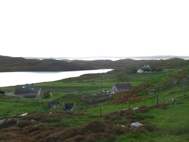
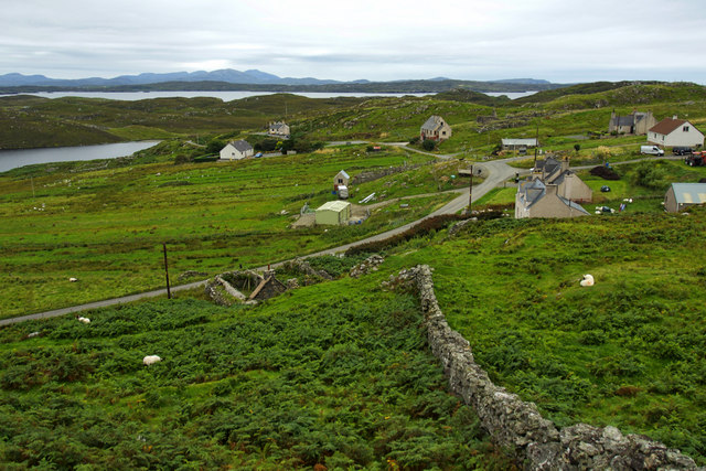
Rubha Thòl is a prominent headland located in Ross-shire, Scotland. This coastal feature is situated on the western coast of the Scottish Highlands, overlooking the North Atlantic Ocean. Offering breathtaking views, Rubha Thòl is known for its rugged cliffs, rocky terrain, and picturesque landscapes.

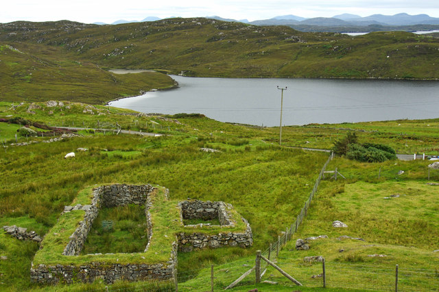
The headland is characterized by its distinctive shape, jutting out into the ocean, forming a prominent point that separates two beautiful bays. The headland is covered in lush green vegetation, with grassy slopes leading down to the cliffs. These cliffs, composed of weathered sandstone and shale, stand tall, providing a natural barrier against the relentless waves crashing against them.

The waters surrounding Rubha Thòl are teeming with marine life, making it an ideal spot for wildlife enthusiasts and birdwatchers. Seals, dolphins, and various species of seabirds can often be spotted in the vicinity. The headland also offers opportunities for coastal walks, providing visitors with an opportunity to explore the rugged coastline and appreciate the natural beauty of the area.

Rubha Thòl has historical significance as well, with remnants of ancient settlements and archaeological sites scattered across the headland. These remains offer a glimpse into the past, providing insights into the lives of those who once inhabited this coastal region.

Overall, Rubha Thòl is a captivating coastal feature, offering a unique combination of natural beauty, wildlife, and historical significance. It is a must-visit destination for those seeking to immerse themselves in the stunning landscapes of the Scottish Highlands.

If you have any feedback on the listing, please let us know in the comments section below.

Rubha Thòl Images

Images are sourced within 2km of 58.268098/-6.8153636 or Grid Reference NB1741. Thanks to Geograph Open Source API. All images are credited.

Dun Carloway Broch A Broch is an Iron Age, drystone structure found almost exclusively in Scotland and the Isles. Designed to impress and defend, they were probably the homes of tribal leaders and important members of the community. They are built with two concentric walls of stone, with a stairway or gallery within the walls to the upper floors. 

Dun Carloway (Dùn Chàrlabhaigh) broch is located above Loch an Dùin on a rocky knoll in a good defensive position. It is one of the best preserved in the Hebrides and some sections of the outer wall stand approximately 9 metres tall so they have survived almost intact. It dates back more than 2000 years; it is thought to have been constructed about 200 BC. Broch-building ceased around AD 100, but they may have continued in use. Evidence from excavations suggests Dun Carloway may have been used until about AD 1000. In the 17th century the broch is said to have been used as a stronghold by members of the Morison Clan when it was besieged by the Macaulays of Uig, with whom they were feuding. The implication is that the wall of the broch were relatively complete until this date.

The broch is a scheduled monument (SM90110 <span class="nowrap"><a title="https://portal.historicenvironment.scot/designation/SM90110" rel="nofollow ugc noopener" href="https://portal.historicenvironment.scot/designation/SM90110">Link</a><img style="margin-left:2px;" alt="External link" title="External link - shift click to open in new window" src="https://s1.geograph.org.uk/img/external.png" width="10" height="10"/></span> Historic Environment Scotland). More information can be found in the statement of significance <span class="nowrap"><a title="https://app-hes-pubs-prod-neu-01.azurewebsites.net/api/file/185e6bb3-1b4d-4c6d-8497-acaf009e3ef6" rel="nofollow ugc noopener" href="https://app-hes-pubs-prod-neu-01.azurewebsites.net/api/file/185e6bb3-1b4d-4c6d-8497-acaf009e3ef6">Link</a><img style="margin-left:2px;" alt="External link" title="External link - shift click to open in new window" src="https://s1.geograph.org.uk/img/external.png" width="10" height="10"/></span>  (pdf file on the HES website).
Dun Carloway Broch
A Broch is an Iron Age, drystone structure found almost exclusively in Scotland and the Isles. Designed to impress and defend, they were probably the homes of tribal leaders and important members of the community. They are built with two concentric walls of stone, with a stairway or gallery within the walls to the upper floors. Dun Carloway (Dùn Chàrlabhaigh) broch is located above Loch an Dùin on a rocky knoll in a good defensive position. It is one of the best preserved in the Hebrides and some sections of the outer wall stand approximately 9 metres tall so they have survived almost intact. It dates back more than 2000 years; it is thought to have been constructed about 200 BC. Broch-building ceased around AD 100, but they may have continued in use. Evidence from excavations suggests Dun Carloway may have been used until about AD 1000. In the 17th century the broch is said to have been used as a stronghold by members of the Morison Clan when it was besieged by the Macaulays of Uig, with whom they were feuding. The implication is that the wall of the broch were relatively complete until this date. The broch is a scheduled monument (SM90110 LinkExternal link Historic Environment Scotland). More information can be found in the statement of significance LinkExternal link (pdf file on the HES website).
Dun Carloway (Dùn Chàrlabhaigh) A Broch is an Iron Age, drystone structure found almost exclusively in Scotland and the Isles. Designed to impress and defend, they were probably the homes of tribal leaders and important members of the community. They are built with two concentric walls of stone, with a stairway or gallery within the walls to the upper floors. 

Dun Carloway (Dùn Chàrlabhaigh) broch is located above Loch an Dùin on a rocky knoll in a good defensive position. It is one of the best preserved in the Hebrides and some sections of the outer wall stand approximately 9 metres tall so they have survived almost intact. It dates back more than 2000 years; it is thought to have been constructed about 200 BC. Broch-building ceased around AD 100, but they may have continued in use. Evidence from excavations suggests Dun Carloway may have been used until about AD 1000. In the 17th century the broch is said to have been used as a stronghold by members of the Morison Clan when it was besieged by the Macaulays of Uig, with whom they were feuding. The implication is that the wall of the broch were relatively complete until this date.

The broch is a scheduled monument (SM90110 <span class="nowrap"><a title="https://portal.historicenvironment.scot/designation/SM90110" rel="nofollow ugc noopener" href="https://portal.historicenvironment.scot/designation/SM90110">Link</a><img style="margin-left:2px;" alt="External link" title="External link - shift click to open in new window" src="https://s1.geograph.org.uk/img/external.png" width="10" height="10"/></span> Historic Environment Scotland). More information can be found in the statement of significance <span class="nowrap"><a title="https://app-hes-pubs-prod-neu-01.azurewebsites.net/api/file/185e6bb3-1b4d-4c6d-8497-acaf009e3ef6" rel="nofollow ugc noopener" href="https://app-hes-pubs-prod-neu-01.azurewebsites.net/api/file/185e6bb3-1b4d-4c6d-8497-acaf009e3ef6">Link</a><img style="margin-left:2px;" alt="External link" title="External link - shift click to open in new window" src="https://s1.geograph.org.uk/img/external.png" width="10" height="10"/></span>  (pdf file on the HES website).
Dun Carloway (Dùn Chàrlabhaigh)
A Broch is an Iron Age, drystone structure found almost exclusively in Scotland and the Isles. Designed to impress and defend, they were probably the homes of tribal leaders and important members of the community. They are built with two concentric walls of stone, with a stairway or gallery within the walls to the upper floors. Dun Carloway (Dùn Chàrlabhaigh) broch is located above Loch an Dùin on a rocky knoll in a good defensive position. It is one of the best preserved in the Hebrides and some sections of the outer wall stand approximately 9 metres tall so they have survived almost intact. It dates back more than 2000 years; it is thought to have been constructed about 200 BC. Broch-building ceased around AD 100, but they may have continued in use. Evidence from excavations suggests Dun Carloway may have been used until about AD 1000. In the 17th century the broch is said to have been used as a stronghold by members of the Morison Clan when it was besieged by the Macaulays of Uig, with whom they were feuding. The implication is that the wall of the broch were relatively complete until this date. The broch is a scheduled monument (SM90110 LinkExternal link Historic Environment Scotland). More information can be found in the statement of significance LinkExternal link (pdf file on the HES website).
Dùn Chàrlabhaigh Broch A Broch is an Iron Age, drystone structure found almost exclusively in Scotland and the Isles. Designed to impress and defend, they were probably the homes of tribal leaders and important members of the community. They are built with two concentric walls of stone, with a stairway or gallery within the walls to the upper floors. 

Dun Carloway (Dùn Chàrlabhaigh) broch is located above Loch an Dùin on a rocky knoll in a good defensive position. It is one of the best preserved in the Hebrides and some sections of the outer wall stand approximately 9 metres tall so they have survived almost intact. It dates back more than 2000 years; it is thought to have been constructed about 200 BC. Broch-building ceased around AD 100, but they may have continued in use. Evidence from excavations suggests Dun Carloway may have been used until about AD 1000. In the 17th century the broch is said to have been used as a stronghold by members of the Morison Clan when it was besieged by the Macaulays of Uig, with whom they were feuding. The implication is that the wall of the broch were relatively complete until this date.

The broch is a scheduled monument (SM90110 <span class="nowrap"><a title="https://portal.historicenvironment.scot/designation/SM90110" rel="nofollow ugc noopener" href="https://portal.historicenvironment.scot/designation/SM90110">Link</a><img style="margin-left:2px;" alt="External link" title="External link - shift click to open in new window" src="https://s1.geograph.org.uk/img/external.png" width="10" height="10"/></span> Historic Environment Scotland). More information can be found in the statement of significance <span class="nowrap"><a title="https://app-hes-pubs-prod-neu-01.azurewebsites.net/api/file/185e6bb3-1b4d-4c6d-8497-acaf009e3ef6" rel="nofollow ugc noopener" href="https://app-hes-pubs-prod-neu-01.azurewebsites.net/api/file/185e6bb3-1b4d-4c6d-8497-acaf009e3ef6">Link</a><img style="margin-left:2px;" alt="External link" title="External link - shift click to open in new window" src="https://s1.geograph.org.uk/img/external.png" width="10" height="10"/></span>  (pdf file on the HES website).
Dùn Chàrlabhaigh Broch
A Broch is an Iron Age, drystone structure found almost exclusively in Scotland and the Isles. Designed to impress and defend, they were probably the homes of tribal leaders and important members of the community. They are built with two concentric walls of stone, with a stairway or gallery within the walls to the upper floors. Dun Carloway (Dùn Chàrlabhaigh) broch is located above Loch an Dùin on a rocky knoll in a good defensive position. It is one of the best preserved in the Hebrides and some sections of the outer wall stand approximately 9 metres tall so they have survived almost intact. It dates back more than 2000 years; it is thought to have been constructed about 200 BC. Broch-building ceased around AD 100, but they may have continued in use. Evidence from excavations suggests Dun Carloway may have been used until about AD 1000. In the 17th century the broch is said to have been used as a stronghold by members of the Morison Clan when it was besieged by the Macaulays of Uig, with whom they were feuding. The implication is that the wall of the broch were relatively complete until this date. The broch is a scheduled monument (SM90110 LinkExternal link Historic Environment Scotland). More information can be found in the statement of significance LinkExternal link (pdf file on the HES website).
Broch at Doune Carloway A Broch is an Iron Age, drystone structure found almost exclusively in Scotland and the Isles. Designed to impress and defend, they were probably the homes of tribal leaders and important members of the community. They are built with two concentric walls of stone, with a stairway or gallery within the walls to the upper floors. 

Dun Carloway (Dùn Chàrlabhaigh) broch is located above Loch an Dùin on a rocky knoll in a good defensive position. It is one of the best preserved in the Hebrides and some sections of the outer wall stand approximately 9 metres tall so they have survived almost intact. It dates back more than 2000 years; it is thought to have been constructed about 200 BC. Broch-building ceased around AD 100, but they may have continued in use. Evidence from excavations suggests Dun Carloway may have been used until about AD 1000. In the 17th century the broch is said to have been used as a stronghold by members of the Morison Clan when it was besieged by the Macaulays of Uig, with whom they were feuding. The implication is that the wall of the broch were relatively complete until this date.

The broch is a scheduled monument (SM90110 <span class="nowrap"><a title="https://portal.historicenvironment.scot/designation/SM90110" rel="nofollow ugc noopener" href="https://portal.historicenvironment.scot/designation/SM90110">Link</a><img style="margin-left:2px;" alt="External link" title="External link - shift click to open in new window" src="https://s1.geograph.org.uk/img/external.png" width="10" height="10"/></span> Historic Environment Scotland). More information can be found in the statement of significance <span class="nowrap"><a title="https://app-hes-pubs-prod-neu-01.azurewebsites.net/api/file/185e6bb3-1b4d-4c6d-8497-acaf009e3ef6" rel="nofollow ugc noopener" href="https://app-hes-pubs-prod-neu-01.azurewebsites.net/api/file/185e6bb3-1b4d-4c6d-8497-acaf009e3ef6">Link</a><img style="margin-left:2px;" alt="External link" title="External link - shift click to open in new window" src="https://s1.geograph.org.uk/img/external.png" width="10" height="10"/></span>  (pdf file on the HES website).
Broch at Doune Carloway
A Broch is an Iron Age, drystone structure found almost exclusively in Scotland and the Isles. Designed to impress and defend, they were probably the homes of tribal leaders and important members of the community. They are built with two concentric walls of stone, with a stairway or gallery within the walls to the upper floors. Dun Carloway (Dùn Chàrlabhaigh) broch is located above Loch an Dùin on a rocky knoll in a good defensive position. It is one of the best preserved in the Hebrides and some sections of the outer wall stand approximately 9 metres tall so they have survived almost intact. It dates back more than 2000 years; it is thought to have been constructed about 200 BC. Broch-building ceased around AD 100, but they may have continued in use. Evidence from excavations suggests Dun Carloway may have been used until about AD 1000. In the 17th century the broch is said to have been used as a stronghold by members of the Morison Clan when it was besieged by the Macaulays of Uig, with whom they were feuding. The implication is that the wall of the broch were relatively complete until this date. The broch is a scheduled monument (SM90110 LinkExternal link Historic Environment Scotland). More information can be found in the statement of significance LinkExternal link (pdf file on the HES website).
Dun Carloway A Broch is an Iron Age, drystone structure found almost exclusively in Scotland and the Isles. Designed to impress and defend, they were probably the homes of tribal leaders and important members of the community. They are built with two concentric walls of stone, with a stairway or gallery within the walls to the upper floors. 

Dun Carloway (Dùn Chàrlabhaigh) broch is located above Loch an Dùin on a rocky knoll in a good defensive position. It is one of the best preserved in the Hebrides and some sections of the outer wall stand approximately 9 metres tall so they have survived almost intact. It dates back more than 2000 years; it is thought to have been constructed about 200 BC. Broch-building ceased around AD 100, but they may have continued in use. Evidence from excavations suggests Dun Carloway may have been used until about AD 1000. In the 17th century the broch is said to have been used as a stronghold by members of the Morison Clan when it was besieged by the Macaulays of Uig, with whom they were feuding. The implication is that the wall of the broch were relatively complete until this date.

The broch is a scheduled monument (SM90110 <span class="nowrap"><a title="https://portal.historicenvironment.scot/designation/SM90110" rel="nofollow ugc noopener" href="https://portal.historicenvironment.scot/designation/SM90110">Link</a><img style="margin-left:2px;" alt="External link" title="External link - shift click to open in new window" src="https://s1.geograph.org.uk/img/external.png" width="10" height="10"/></span> Historic Environment Scotland). More information can be found in the statement of significance <span class="nowrap"><a title="https://app-hes-pubs-prod-neu-01.azurewebsites.net/api/file/185e6bb3-1b4d-4c6d-8497-acaf009e3ef6" rel="nofollow ugc noopener" href="https://app-hes-pubs-prod-neu-01.azurewebsites.net/api/file/185e6bb3-1b4d-4c6d-8497-acaf009e3ef6">Link</a><img style="margin-left:2px;" alt="External link" title="External link - shift click to open in new window" src="https://s1.geograph.org.uk/img/external.png" width="10" height="10"/></span>  (pdf file on the HES website).
Dun Carloway
A Broch is an Iron Age, drystone structure found almost exclusively in Scotland and the Isles. Designed to impress and defend, they were probably the homes of tribal leaders and important members of the community. They are built with two concentric walls of stone, with a stairway or gallery within the walls to the upper floors. Dun Carloway (Dùn Chàrlabhaigh) broch is located above Loch an Dùin on a rocky knoll in a good defensive position. It is one of the best preserved in the Hebrides and some sections of the outer wall stand approximately 9 metres tall so they have survived almost intact. It dates back more than 2000 years; it is thought to have been constructed about 200 BC. Broch-building ceased around AD 100, but they may have continued in use. Evidence from excavations suggests Dun Carloway may have been used until about AD 1000. In the 17th century the broch is said to have been used as a stronghold by members of the Morison Clan when it was besieged by the Macaulays of Uig, with whom they were feuding. The implication is that the wall of the broch were relatively complete until this date. The broch is a scheduled monument (SM90110 LinkExternal link Historic Environment Scotland). More information can be found in the statement of significance LinkExternal link (pdf file on the HES website).
Doune Carloway
Doune Carloway
Doune Carloway, view from the broch The village of Doune is named after its Iron Age broch (<a href="https://www.geograph.org.uk/photo/7630277">NB1941 : Dun Carloway Broch</a>). Doune Carloway was at one time a farm, along with Kirvick but in 1828 it was divided into crofts for tenants evicted from Hacklete, Bernera.
Doune Carloway, view from the broch
The village of Doune is named after its Iron Age broch (NB1941 : Dun Carloway Broch). Doune Carloway was at one time a farm, along with Kirvick but in 1828 it was divided into crofts for tenants evicted from Hacklete, Bernera.
Doune Carloway, Loch an Dùin and the coast View to the west from <a href="https://www.geograph.org.uk/photo/7630291">NB1941 : Broch at Doune Carloway</a> past  Loch an Dùin and the edge of the village, towards the coast.
Doune Carloway, Loch an Dùin and the coast
View to the west from NB1941 : Broch at Doune Carloway past Loch an Dùin and the edge of the village, towards the coast.
View from Dun Carloway Broch - Loch an Dùin Looking south from <a href="https://www.geograph.org.uk/photo/7630291">NB1941 : Broch at Doune Carloway</a>.
View from Dun Carloway Broch - Loch an Dùin
Looking south from NB1941 : Broch at Doune Carloway.
Dùn Chàrlabhaigh The broch at Carloway.
Dùn Chàrlabhaigh
The broch at Carloway.
Blackhouse base at Carloway Seen from the path that leads to the broch.
Blackhouse base at Carloway
Seen from the path that leads to the broch.
Welcome to Dùn Chàrlabhaigh Historic Scotland information panel about the broch.
Welcome to Dùn Chàrlabhaigh
Historic Scotland information panel about the broch.
Lazy beds below Cnoc Buaile Fang, Isle of Lewis
Broch at Doun Carloway
Dun Charlabhaigh
Dun Charlabhaigh
Dòun Chàrlabhaigh
Dòun Chàrlabhaigh
Ruins and Loch an Dùin
Carloway Broch, from the access path
Show me another place!

Rubha Thòl is located at Grid Ref: NB1741 (Lat: 58.268098, Lng: -6.8153636)

Unitary Authority: Na h-Eileanan an Iar

Police Authority: Highlands and Islands

What 3 Words

///shipyards.trail.headliner. Near Carloway, Na h-Eileanan Siar

Related Wikis

Dun Carloway

Dun Carloway (Scottish Gaelic: Dùn Chàrlabhaigh) is a broch situated in the district of Carloway, on the west coast of the Isle of Lewis, Scotland (grid...

Borrowston, Lewis

Borrowston (Scottish Gaelic: Borghastan), with a population of about 50, is a crofting township situated on the Isle of Lewis, on the Outer Hebrides of...

Cealasaigh

Cealasaigh or Kealasay is an islet in outer Loch Ròg, Lewis, Scotland that lies north of Traigh Mhór on Little Bernera and south of Campaigh. To the west...

Carloway

Carloway (Scottish Gaelic: Càrlabhagh [ˈkʰaːɾɫ̪ə.ɤː]) is a crofting township and a district on the west coast of the Isle of Lewis, in the Outer Hebrides...

Garenin

Garenin (Scottish Gaelic: Na Gearrannan) is a crofting township on the west coast of the Isle of Lewis in the Outer Hebrides of Scotland. Garenin is in...

Little Bernera

Little Bernera (Scottish Gaelic: Beàrnaraigh Beag) is a small island situated off the west coast of the Isle of Lewis in the Outer Hebrides.Little Bernera...

Tolsta Chaolais

Tolsta Chaolais (also Tolastadh Chaolais, Tolstadh a' Chaolais) is a village on the Isle of Lewis, Scotland. It consists of about forty houses, clustered...

Campaigh

Campaigh or Campay is a steep and rocky islet in outer Loch Ròg, Lewis, Scotland that lies north of Cealasaigh and Little Bernera. A huge natural arch...

Nearby Amenities

Located within 500m of 58.268098,-6.8153636
Rudhag
Natural: bay
Lat/Long: 58.2667376/-6.8143811
The data included in this document is from www.openstreetmap.org. The data is made available under ODbL.

Have you been to Rubha Thòl?

Leave your review of Rubha Thòl below (or comments, questions and feedback).