Freelands Plantation

Wood, Forest in Norfolk South Norfolk

England

Freelands Plantation

Boathouse Hill Cottages
Boathouse Hill Cottages Credit: Matthew Chadwick

Freelands Plantation, located in Norfolk, is a picturesque woodland area encompassing vast stretches of lush greenery and a diverse array of flora and fauna. Covering an area of approximately 250 acres, this plantation is a haven for nature enthusiasts and those seeking a serene escape from urban life.

The woodland is primarily composed of deciduous trees such as oak, beech, and maple, which create a dense canopy that provides shade and shelter to a variety of smaller plants and animals. The forest floor is carpeted with a rich undergrowth of ferns, wildflowers, and mosses, adding to the enchanting beauty of the landscape.

Freelands Plantation is home to numerous species of wildlife, including deer, rabbits, squirrels, and a variety of bird species such as woodpeckers, owls, and warblers. Birdwatching enthusiasts flock to this area to observe and document the diverse avian population.

Walking trails and well-maintained pathways wind through the plantation, allowing visitors to explore and immerse themselves in the natural beauty of the surroundings. These trails are often used by hikers, joggers, and dog walkers, offering a peaceful and scenic environment for exercise and relaxation.

The plantation also serves as an important conservation area, with efforts in place to protect and preserve the natural habitat. Environmental organizations collaborate with local authorities to maintain the ecological balance and promote sustainable practices within the plantation.

Freelands Plantation in Norfolk is a cherished natural treasure, attracting visitors from near and far with its stunning woodland landscapes, abundant wildlife, and tranquil atmosphere. It is truly a sanctuary where one can reconnect with nature and appreciate the wonders of the natural world.

If you have any feedback on the listing, please let us know in the comments section below.

Freelands Plantation Images

Images are sourced within 2km of 52.486474/1.5772983 or Grid Reference TM4293. Thanks to Geograph Open Source API. All images are credited.

Boathouse Hill Cottages
Stanchion for old railway bridge
Angles Way
Angles Way
Former railway bridge support On River Waveney. Railway formerly connecting Beccles with Haddiscoe and St Olaves to the north directly, across the marshes.
Former railway bridge support
On River Waveney. Railway formerly connecting Beccles with Haddiscoe and St Olaves to the north directly, across the marshes.
Beccles, River Waveney Circular Walk 3: 'Ukraine Desolate Street'
Beccles, River Waveney Circular Walk 4: Gated field
Beccles, River Waveney Circular Walk 5: Scene
Beccles, River Waveney Circular Walk 8: Farm track
Beccles, River Waveney Circular Walk 7: Track with trees on either side
Beccles, River Waveney Circular Walk 9: Bulrush 'Typha latifolia'
Beccles, River Waveney Circular Walk 10: Cut tree
Beccles, River Waveney Circular Walk 11: A storm heading our way
Beccles, River Waveney Circular Walk 12: A storm heading our way
Beccles, River Waveney Circular Walk 13: Tree felled by the wind
Beccles, River Waveney Circular Walk 14: Track
Beccles, River Waveney Circular Walk 15: Trees reflected in drainage ditch water
Beccles, River Waveney Circular Walk 16: Drainage ditch
Beccles, River Waveney Circular Walk 17: Footbridge over a drainage ditch
Show me another place!

Freelands Plantation is located at Grid Ref: TM4293 (Lat: 52.486474, Lng: 1.5772983)

Administrative County: Norfolk

District: South Norfolk

Police Authority: Norfolk

What 3 Words

///parsnips.possibly.edits. Near Beccles, Suffolk

Related Wikis

Stanley and Alder Carrs, Aldeby

Stanley and Alder Carrs, Aldeby is a 42.7-hectare (106-acre) biological Site of Special Scientific Interest east of Gillingham in Norfolk. It is part of...

Toft Monks

Toft Monks is a village and parish in Norfolk, England. It is located on the border of Norfolk and Suffolk about eleven miles southwest of Great Yarmouth...

Aldeby

Aldeby is a village and civil parish in the English county of Norfolk. It is bounded to the south by the River Waveney, on the other side of which is Suffolk...
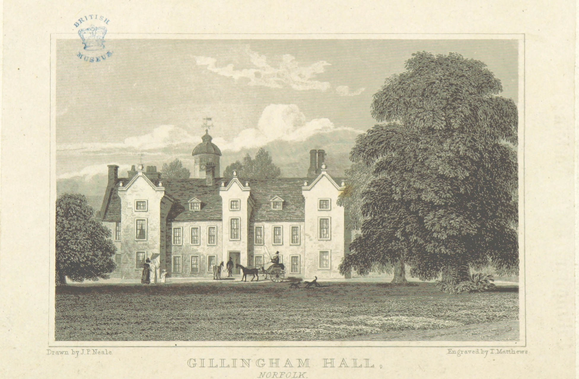
Gillingham Hall

Gillingham Hall is a Jacobean manor house in the village of Gillingham, Norfolk, England. It is a Grade II* Listed Building.The house has 10-bedrooms and...

Nearby Amenities

Located within 500m of 52.486474,1.5772983
Fixme: Does a Public Footpath head north from here?
Lat/Long: 52.4850145/1.5761334
Elms Road, adj
Naptan AtcoCode: 2900A076
Naptan Bearing: NE
Naptan BusStopType: CUS
Naptan CommonName: Elms Road
Naptan Indicator: adj
Naptan Landmark: Elms Road
Naptan Locality: Aldeby
Naptan NaptanCode: nfoadawm
Naptan Street: Beccles Road
Naptan Verified: no
Note: Street is 'Hollow Way Hill'
Source: naptan_import
Lat/Long: 52.4829642/1.5804447
Elms Road, opp
Naptan AtcoCode: 2900A077
Naptan Bearing: SW
Naptan BusStopType: CUS
Naptan CommonName: Elms Road
Naptan Indicator: opp
Naptan Locality: Aldeby
Naptan NaptanCode: nfoadawp
Naptan Street: Beccles Road
Naptan Verified: no
Note: Street is 'Hollow Way Hill'
Source: naptan_import
Lat/Long: 52.4828614/1.5799796
Barrier: stile
Foot: yes
Lat/Long: 52.484569/1.5740044
Grit Bin
Lat/Long: 52.4852728/1.572386
Give Way
Lat/Long: 52.4829223/1.5801765
Power: pole
Lat/Long: 52.4833764/1.5750656
Material: wood
Power: pole
Lat/Long: 52.482251/1.5757334
Location Transition: yes
Power: pole
Lat/Long: 52.4860454/1.571297
Power: pole
Lat/Long: 52.4849445/1.5706721
Power: pole
Lat/Long: 52.4857187/1.5711254
Power: pole
Lat/Long: 52.4853333/1.5708974
The data included in this document is from www.openstreetmap.org. The data is made available under ODbL.

Have you been to Freelands Plantation?

Leave your review of Freelands Plantation below (or comments, questions and feedback).