Kingstall Wood

Wood, Forest in Suffolk East Suffolk

England

Kingstall Wood

Footpath to Edwards Lane <span class="nowrap"><a title="https://en.wikipedia.org/wiki/Walpole,_Suffolk" rel="nofollow ugc noopener" href="https://en.wikipedia.org/wiki/Walpole,_Suffolk">Link</a><img style="margin-left:2px;" alt="External link" title="External link - shift click to open in new window" src="https://s1.geograph.org.uk/img/external.png" width="10" height="10"/></span>
Footpath to Edwards Lane Credit: Geographer

Kingstall Wood is a picturesque forest located in the county of Suffolk, England. Stretching over an area of approximately 200 acres, it is a popular destination for nature enthusiasts and outdoor lovers. The wood is situated near the village of Kingstall, which adds to its charm and accessibility.

Kingstall Wood is known for its diverse range of flora and fauna, making it a haven for wildlife. The forest is predominantly composed of native tree species, including oak, beech, and birch. These towering trees create a dense canopy that provides shelter and nesting grounds for various bird species, such as woodpeckers and owls.

Visitors to Kingstall Wood can enjoy a number of walking trails that wind through the forest, offering scenic views and peaceful surroundings. The area is well-maintained, with clearly marked paths that cater to different levels of fitness and mobility. Along these trails, one can discover hidden ponds, meandering streams, and vibrant wildflowers, adding to the natural beauty of the wood.

For those interested in history, Kingstall Wood holds significance as it was once part of a larger medieval hunting forest. The remnants of ancient boundaries and earthworks can still be seen, serving as a reminder of its rich past.

The wood is open to the public year-round, providing a tranquil escape from the hustle and bustle of everyday life. Whether it's for a leisurely stroll, birdwatching, or simply enjoying the serenity of nature, Kingstall Wood offers a delightful experience for all who visit.

If you have any feedback on the listing, please let us know in the comments section below.

Kingstall Wood Images

Images are sourced within 2km of 52.30462/1.5020953 or Grid Reference TM3873. Thanks to Geograph Open Source API. All images are credited.

Footpath to Edwards Lane <span class="nowrap"><a title="https://en.wikipedia.org/wiki/Walpole,_Suffolk" rel="nofollow ugc noopener" href="https://en.wikipedia.org/wiki/Walpole,_Suffolk">Link</a><img style="margin-left:2px;" alt="External link" title="External link - shift click to open in new window" src="https://s1.geograph.org.uk/img/external.png" width="10" height="10"/></span>
Footpath to Edwards Lane
Field near Waterloo Farm
Remains of a trackside building
Cut Mark Bramfield St Andrew's Church Cut Mark Bramfield St Andrew's Church, S buttress face, SE angle.
Cut Mark Bramfield St Andrew's Church
Cut Mark Bramfield St Andrew's Church, S buttress face, SE angle.
Field near Bright's Farm
Old Milepost by the A144, Bramfield Metal plate attached to stone post by the A144, in parish of Bramfield (Suffolk Coastal District), Bramfield, North end of village by the road. Garrett face iron casting, erected by the Ipswich to South Town, & Darsham to Bungay Turnpike Trust in the 19th century. 

Inscription reads:-
: BUNGAY 11 / HALESWORTH 2 : : BRAMFIELD / TO / LONDON / 98 : : IPSWICH 29 / SAXMUNDHAM 9 :
Maker:-
: J GARRETT / IRON FOUNDER / ST MARGARET'S / IPSWICH / 1818 : 

Milestone Society National ID: SU_BGIW11.
Old Milepost by the A144, Bramfield
Metal plate attached to stone post by the A144, in parish of Bramfield (Suffolk Coastal District), Bramfield, North end of village by the road. Garrett face iron casting, erected by the Ipswich to South Town, & Darsham to Bungay Turnpike Trust in the 19th century. Inscription reads:- : BUNGAY 11 / HALESWORTH 2 : : BRAMFIELD / TO / LONDON / 98 : : IPSWICH 29 / SAXMUNDHAM 9 : Maker:- : J GARRETT / IRON FOUNDER / ST MARGARET'S / IPSWICH / 1818 : Milestone Society National ID: SU_BGIW11.
Sibton Green & Sibton Green Village sign Road No.C212
Sibton Green & Sibton Green Village sign
Road No.C212
Sibton Green Village Sign Off Sibton Green
Sibton Green Village Sign
Off Sibton Green
Sibton Green Road No.C212
Sibton Green
Road No.C212
Footpath to Packway & Earlsway Farms Off Sibton Green
Sibton footpath No.7 leading to Walpole footpath No.16 & Walpole Bridleway No.15
Footpath to Packway & Earlsway Farms
Off Sibton Green Sibton footpath No.7 leading to Walpole footpath No.16 & Walpole Bridleway No.15
Sibton Green Wind Turbine Taken from Sibton Green
Sibton Green Wind Turbine
Taken from Sibton Green
Sibton Green Village Sign Off Sibton Green
(Close up)
Sibton Green Village Sign
Off Sibton Green (Close up)
Sibton Green At the junction with Hollow Lane (New Road)
Road No.C212
Sibton Green
At the junction with Hollow Lane (New Road) Road No.C212
Sibton Green At the junction with Hollow Lane (New Road)
Road No.C212
Sibton Green
At the junction with Hollow Lane (New Road) Road No.C212
North Green Farm, Sibton Green Off Sibton Green at the junction with New Road
North Green Farm, Sibton Green
Off Sibton Green at the junction with New Road
Sibton Green At the junction with Hollow Lane (New Road)
Road No.C212
Sibton Green
At the junction with Hollow Lane (New Road) Road No.C212
Sibton Green At the junction with Hollow Lane (New Road)
Road No.C212
Sibton Green
At the junction with Hollow Lane (New Road) Road No.C212
Sibton Green At the junction with Weavers Marsh Lane & Sibton Road near Green Farm
Road No.C212
Sibton Green
At the junction with Weavers Marsh Lane & Sibton Road near Green Farm Road No.C212
Show me another place!

Kingstall Wood is located at Grid Ref: TM3873 (Lat: 52.30462, Lng: 1.5020953)

Administrative County: Suffolk

District: East Suffolk

Police Authority: Suffolk

What 3 Words

///voltage.emulating.quarrel. Near Cookley, Suffolk

Nearby Locations

Kingstall Wood

Related Wikis

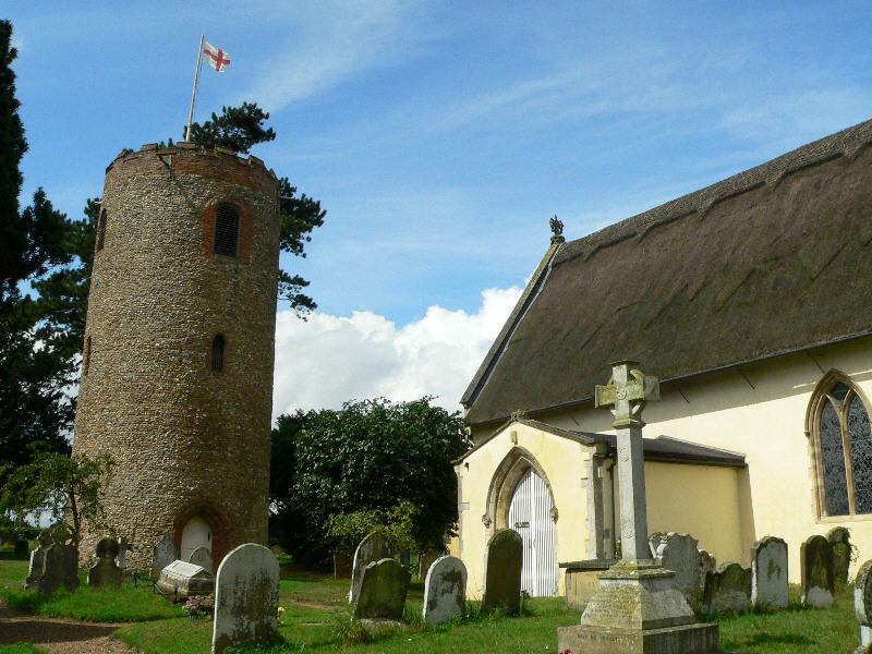
St Andrew's Church, Bramfield

St Andrew's Church is a 13th-century church in Bramfield, Suffolk. It has a separate 12th-century tower standing in the church grounds. It is one of 38...

Bramfield, Suffolk

Bramfield is a village and civil parish in the east of the English county of Suffolk, and in the East Suffolk district. It is 5 miles (8.0 km) south of...

Dew's Ponds

Dew's Ponds is a 6.7-hectare (17-acre) biological Site of Special Scientific Interest (SSSI) south of Halesworth in Suffolk. It is a Special Area of Conservation...

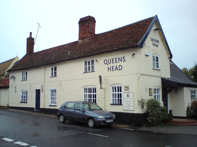
Queen's Head, Bramfield

The Queen's Head is a pub in Bramfield, Suffolk, England. The pub was formerly known as the "Skeltons". It is a Grade II listed building, which dates back...

Nearby Amenities

Located within 500m of 52.30462,1.5020953
The data included in this document is from www.openstreetmap.org. The data is made available under ODbL.

Have you been to Kingstall Wood?

Leave your review of Kingstall Wood below (or comments, questions and feedback).